Chapter III: The Upper-Level Trough Stage
The Upper-Level Trough Stage
The intensity of mid-latitude westerlies (i.e., the corresponding geostrophic wind in higher levels) strongly depends on the meridional pressure difference between approximately 35° and 55° north. A large pressure difference between both latitudes goes hand in hand with a strong westerly component of wind flow and is called a high index circulation. Similarly, in the case of a low index circulation, a weak westerly flow prevails and hence the wind flow's north-south component is relatively stronger.
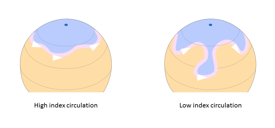
Figure 1: Rossby waves in high (left) and low index circulations (right). Blue represents the polar air mass, and orange the warmer air masses. The pink ribbon marks the position of the jet stream. © Fred the Oyster, CC-BY-SA.
Troughs and their associated upper-level lows emerge with the transition from a high index circulation to a low index one.
Most ULLs remain stuck in the first stage of development. They form within an upper-level trough and persist as long as the trough expands. As soon as the trough withdraws, the ULL vanishes.
Figure 2: Airmass RGB loop and geopotential at 500 hPa from 11 January 2021 at 12:00 UTC to 13 January 2021 at 00:00 UTC.
The above loop shows an upper-level low that forms within a pronounced upper-level trough which moves southeast along the Italian peninsula. This ULL remains within the cold air of an upper-level trough and never tears-off from the polar air mass. This is a very common phenomenon seen in upper-level troughs, especially when they take an elongated form as in this example. In some cases, up to three closed circulations at higher levels can be found inside the trough without a corresponding surface low.
What Causes Upper-Level Troughs to Develop?
As a starting point, we image a polar front that is oriented east to west in a straight line, and separates colder polar air from warmer tropical air. This front shows no or little signs of weather activity. The isolines of temperature and pressure are parallel to each other at any level above ground (see Figure 3).
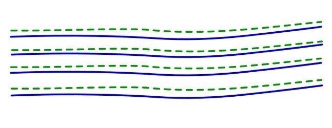
Figure 3: Initial condition of the polar front before trough formation. The temperature isolines (green dotted line) and the geopotential height (blue line) are parallel to each other at all atmospheric levels.
However, when considered in a vertical cross-section, warm air masses are thicker than cold ones. As a result of this, pressure surfaces are more strongly inclined at higher levels than close to the ground (see Figure 4). Consequently, geostrophic winds will increase with height and result in jet force winds below the tropopause.
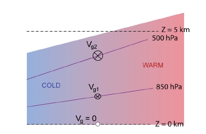
Figure 4: The inclination of isobars increases steadily with height at an air mass boundary such as the polar front. Vg is the geostrophic wind.
In reality, differential heating of the surface terrain permanently influences the polar front, as do orographic features such as mountain ranges, which deviate the westerly flow (see the training module on Lee Cyclogenesis).
When such a perturbation of the polar front occurs, such as through cold air protruding to the south or a warm air mass moving north, a shift between the thermal and geopotential wave can be observed (see Figure 5).
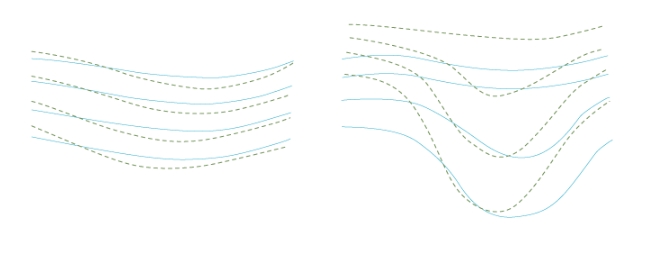
Figure 5: For an amplifying trough, the temperature wave (green dotted line) lags behind the geopotential wave (blue line). Both parameters are depicted at the 500 hPa pressure level.
During their formation, troughs do not exhibit a closed circulation. The trough axis is usually inclined northeast to southwest in the early phase (positive tilt) and northwest to southeast when dissipating (negative tilt).
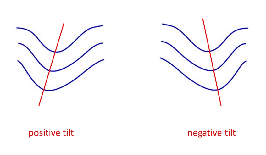
Figure 6: Schematic of troughs with positive and negative tilt (red line). Blue lines show the geopotential height at 500 hPa.
A vertical cross-section would show the area of lowest pressure inclined backwards in the early stage and moving into an upright position towards the end of the process's life cycle. This is especially true for troughs connected with a pressure minimum at the surface level, which is caused by upper-level dynamics at jet-level (see the effect of curvature).
In some cases, the upper-level dynamics involved in the creation of a trough are not strong enough to produce an effect at ground level (for the basics see the effect of mass conservation). This is especially true when upper-level divergence is weak due to missing acceleration and deceleration of the jet stream.