Synoptic Situation: Satellite Images, weather and basic numerical parameters
The cloud system under investigation is first observed far in the north and consists of two parts: cloudiness in the cold air north of 70 N and a cloud band between 65 and 70 N that extends across the Norwegian Sea to the Norwegian coast. During the following 12 hours in the lee of the Norwegian mountains high lee clouds develop while the cloud band diminishes more and more.
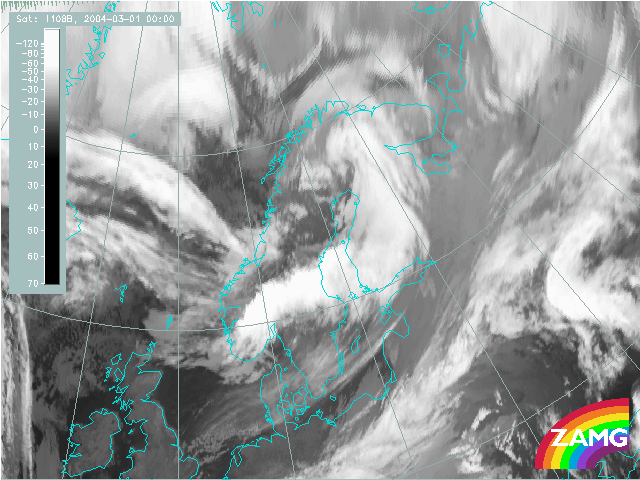
1 March 2004/00.00 UTC - Meteosat-8 IR10.8
|
In the same time period the cloudiness behind the frontal band forms more and more to a distinct comma which approaches N- Norway and moves across N-Sweden into Finland. During this time it has developed into a synoptic scale cloud spiral which in the end covers Finland, the Baltic Sea, the Baltic States and Poland. |
Meteosat-8 IR 10.8μm image: time sequence
In the next chapter the development of the cloud spiral in relevant satellite channels (IR MSG channel 10.8) are shown and described in a sequence of hourly to 3-hourly images.
Meteosat-8 WV 6.2μm image: time sequence
In the next chapter the development of the cloud spiral from the view of the WV images are shown and described in a sequence of hourly to 3-hourly images.
IR image and Geopotential height 1000 hPa: time sequence
In the following chapter the cloud configurations seen in satellite images are related to the basic field of surface pressure represented by geopotential height in 1000 hPa. 6-hourly sequences are shown.
IR image and Geopotential height 500 hPa: time sequence
In the following chapter the cloud configurations seen in satellite images are related to the basic field of the upper level height in 500 hPa. 6-hourly sequences are shown.
IR image and weather: time sequence
In the following set of images observations of snow, rain and thunderstorms are related to the cloud configurations seen in satellite images in 3-hourly sequences.
Summary of the investigations in this chapter
This case of development of a distinct synoptic-scale cloud spiral shows some basic deviations from the classical developments of an occlusion:
- The cloud spiral develops from a cloud feature, typically a comma feature in the cold air far in the North; Especially during this phase , the WV image can explain small scale phenomena like the development of a street of curls where dry probably stratospheric air is sinking above a rather unstructured cloud shield;
- The development of the cloud structure later shows two main areas: the intensification of the comma head into a distinct spiral and the cloud development at the comma tail into a broad synoptic scale cloud band;
- The WV image shows how the dry air is partly streaming over the cloud band.
- Surface and upper level low are quite intensive from the very early stages of comma development on; both lows deepen and become a very sharp structure within one day; the scale of the lows is rather meso-scale
- The upper level trough and later the upper level low is only in the very beginning far behind the surface low; it approaches the surface low very soon and within about one day a thick, intensive low system with a nearly vertical axis from the surface up into high levels develops.