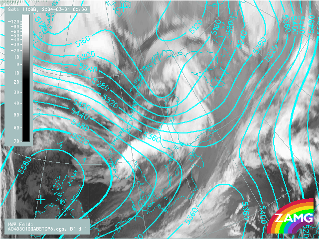
1st March 2004: 00UTC
As for the geopotential height at 1000 hPa, also here the main phenomenon at this point of time is the intensive upper level trough over N-Sweden and on the rear of the synoptic scale cloud spiral. The interesting feature for this case study however is found much more to the NW, an upper level trough in connection to the cold air cloudiness north of 70 degree. At this point of time this upper level trough is clearly behind the corresponding surface low.
1st March 2004: 06UTC
The upper level trough in the north is moving very fast and is now still behind the corresponding surface low but much closer than 6 hours before.
1st March 2004: 12UTC
A SE-ward shift of the secondary upper level trough shows the trough at the rear side of the comma feature as well as at the rear side of the surface low.
1st March 2004: 18UTC
At this point in time the comma feature is well developed. The upper level trough seems to become a very sharp minimum in the innermost part while it becomes more flat in the outer part of the isolines.
2nd March 2004: 00UTC
Within the large scale upper level trough extending from North Russia to Central Europe a very small scale secondary trough develops exactly above the comma head. This is a bit to the N, NW of the low in the surface layer 1000 hPa.
2nd March 2004: 06UTC
The small scale upper level trough becomes more pronounced and is still above the comma head a bit shifted to the N, NW of the surface low.
2nd March 2004: 12UTC
The development goes on and a closed upper level low center is formed. It is still a bit shifted to the NW of the the surface low.
2nd March 2004: 18UTC
The cut off process goes on and a larger closed upper level low develops.
3rd March 2004: 00UTC
Also during the last 6 hours the cut off process has continued. In the end phase of the case study presented here a meso- to synoptic scale low pressure center throughout the whole troposphere has developed and accompanies the cloud spiral.