1st March 2004: 00UTC
The image shows a W-E oriented cloud band from the S-part of Greenland along approximately 70 N extending eastward to the Norwegian coast. North of this cloud band along 10 W there is a big cloudmass which cannot be seen in its full content at this point of time. A NOAA image of about 1 - 2 hours later shows a rather low cloud which is not cyclonically curved.
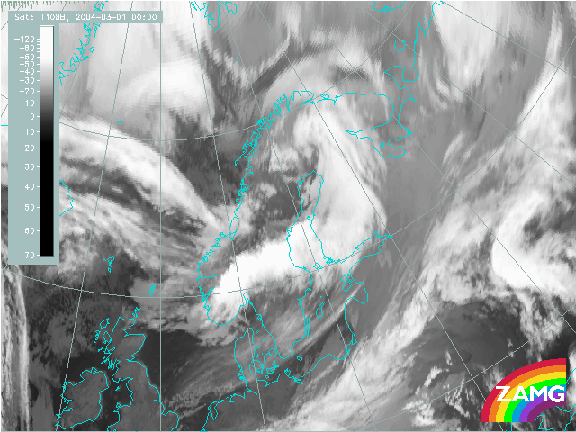
1st March 2004: 03UTC
The cloud configurations are very similar to 3 hours before only the eastward movement of the cloud shield north of the W-E oriented cloud band is very evident.
1st March 2004: 06UTC
Again the main features are very similar but there are two small scale features which have developed during the last three hours:
A small scale cloud dissolution in the W-E oriented cloud band at 70N05W
A small scale cyclonic curl immediately north of it. Especially this area of the curl will turn out to be the nucleus of the whole cyclonic development. A NOAA image which seems to correspond in time very well shows these two small scale features with the much better space resolution. The character of the whole cloud field resembles that of a thickness ridge cloudiness under the influence of large scale WA. This has to be proved by relevant numerical parameters.
1st March 2004: 07UTC
There is some further development in the area of the small scale curls. To the north of the first one a second curl, which is not so well formed, seems to develop.
1st March 2004: 08UTC
There is some further development in the area of the small scale curls. To the north of the first one a second curl, which is not so well formed, seems to develop.
1st March 2004: 09UTC
There is some further development in the area of the small scale curls. To the north of the first one a second curl, which is not so well formed, seems to develop.
1st March 2004: 10UTC
The main new element can be observed immediately east of the two curls around 72N � 9E. In this small area grey shades become brighter, indicative for growing clouds. This will be the area from which the comma structure develops.
1st March 2004: 11UTC
The increase of the cloud tops in the area just described goes on.
1st March 2004: 12UTC
At this point of time a distinct spiral structure develops in the area of cloud increase, which could be followed over the past two hours.
1st March 2004: 13UTC
During the next three hours a street of small scale curls at the western border of the cloud field has developed but the southernmost becomes more and more distinct and moves E, SE-ward. The southern curl of this chain of small scale curls increases and becomes very pronounced.
1st March 2004: 14UTC
During the next two hours a street of small scale curls at the western border of the cloud field has developed but the southernmost becomes more and more distinct and moves E, SE-ward. The southern curl of this chain of small scale curls increases and becomes very pronounced.
1st March 2004: 15UTC
The development of the southernmost cloud spiral goes on. It increases in size and becomes also more distinct.
1st March 2004: 18UTC
At this point of time the increase of the southern cloud spiral has reached the Norwegian coast and looses in the center its distinct spiral form. The more northern smaller curls of this chain of curl decrease.
1st March 2004: 21UTC
The cloud spiral is covering Norway and looses in the center its distinct spiral form.
2nd March 2004: 00UTC
At 00 UTC a well developed comma cloud spiral extends from N-Sweden across W-Finland back to Central Sweden. The Comma head over N-Sweden shows bright grey shades and also a lumpy appearance which indicates convective weather elements, while the comma tail over W-Finland has rather low (warm) cloud tops. There is still some connection to the rest of the cloud band to the South.
2nd March 2004: 01UTC
The comma system becomes an even more distinct spiral structure and in the comma head convective cloudiness intensifies. The comma tail still consists of lower cloud tops but shows now some enlargement of the cloud band.
2nd March 2004: 02UTC
Both processes described before go on quite intensively: the comma head becomes brighter and more comvective, the comma tail remains with lower cloud tops but the bandstructure intensifies and becomes broader.
2nd March 2004: 03UTC
The main phenomenon during the last hour is that the cloud spiral becomes more and more distinct.
2nd March 2004: 04UTC
Also during this last hour the main phenomenon is that the cloud spiral becomes more and more distinct. The size of the comma tail increases.
2nd March 2004: 05UTC
During the last hour the vertical and horizontal increase of cloud cells at the leading side of the comma head is the main phenomenon. The comma tail still increases in width partly through the mergence with other lower cloud fields in front of the comma, partly through development and organisation of cloudiness at the comma tail itself.
2nd March 2004: 06UTC
The comma feature has increased intensively during the last 6 hours and is now a meso- to synoptic scale cloud spiral with a broad cloud band consisting of rather warm tops and a very pronounced cloud spiral with bright (cold) convective cells. The widening the comma tail by mergance with other cloud fields implements the impression as if a mergance between the comma and an (probably old) air mass boundary has taken place. It will be interesting to prove this hypothesis with help of relevant numerical parameters.
2nd March 2004: 09UTC
The cloud spiral becomes more and more distinct . During the last time period also the cloud tops in the frontal band became brighter which means that the cloud tops are growing.
2nd March 2004: 12UTC
The cloud spiral is now situated over Finland and the Baltic States. It shows some double structure in the band area - it looks even like a split front - which might be an indication of the mergence of a comma with an air mass boundary. WV images and numerical parameters should give more insight into this process.
2nd March 2004: 15UTC
The frontal cloud system is now of synoptic scale but shows first signs of de-organisation and/or dissolution of cloudiness.
2nd March 2004: 18UTC
The process described before is going on. But the most striking feature is that the frontal cloud band still grows; during this part of time more to the SW.
2nd March 2004: 21UTC
The system moves eastward, the cloud band is now over White Russia while the Baltic States are crossed by different small scale features from the inner part of the cloud spiral.
3rd March 2004: 00UTC
The end stage in this case studies shows a synoptic scale cloud spiral. But it can be followed quite long futher.