12 March 1996 - Forecast For Enhanced Cumulus
|
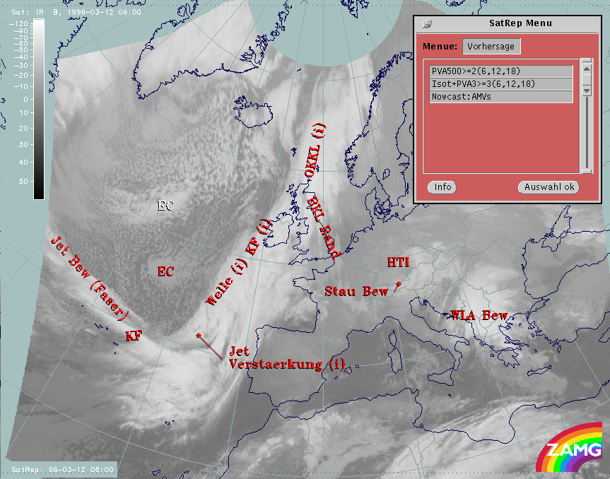
12 March 1996/06.00 UTC - Meteosat IR image; SatRep overlay: names of conceptual models, SatRep menu: key parameters for EC forecast
|
|
|
Concerning the forecast of the conceptual model "EC" in the SatRep Menu a button "Vorhersage = forecast" has to be clicked on, then the relevant menu appears. As can be seen in the right upper corner, two kinds of forecasts and forecast times are presented:
The very short range forecast VSRF (06.00 - 18.00 UTC, 12 hours)
For the very short range forecast, six-hourly forecasts from ECMWF are used. Those parameters which are key parameters of a conceptual model are prepared as overlays on the satellite image in three different colours representing the three points of time 06.00, 12.00 and 18.00 UTC:
- yellow: 06.00 UTC
- green: 12.00 UTC
- blue: 18.00 UTC
In the case of the conceptual model "EC", the PVA at 500 hPa exceeding the threshold of 2 units, as well as the combination of isotachs and PVA at 300 hPa exceeding a threshold of 3 units, are taken into account.
The PVA at 500 hPa is more indicative of situations representing an approaching trough and curvature vorticity, while at 300 hPa the PVA is more indicative of a propagating jet streak and shear vorticity.
Nowcasting (0-2 hours)
For this forecast time, atmospheric motion vectors (AMVs) are used which extrapolate the cloud systems for the next two hours. These nowcasts are renewed half-hourly or hourly and are not discussed here.
|
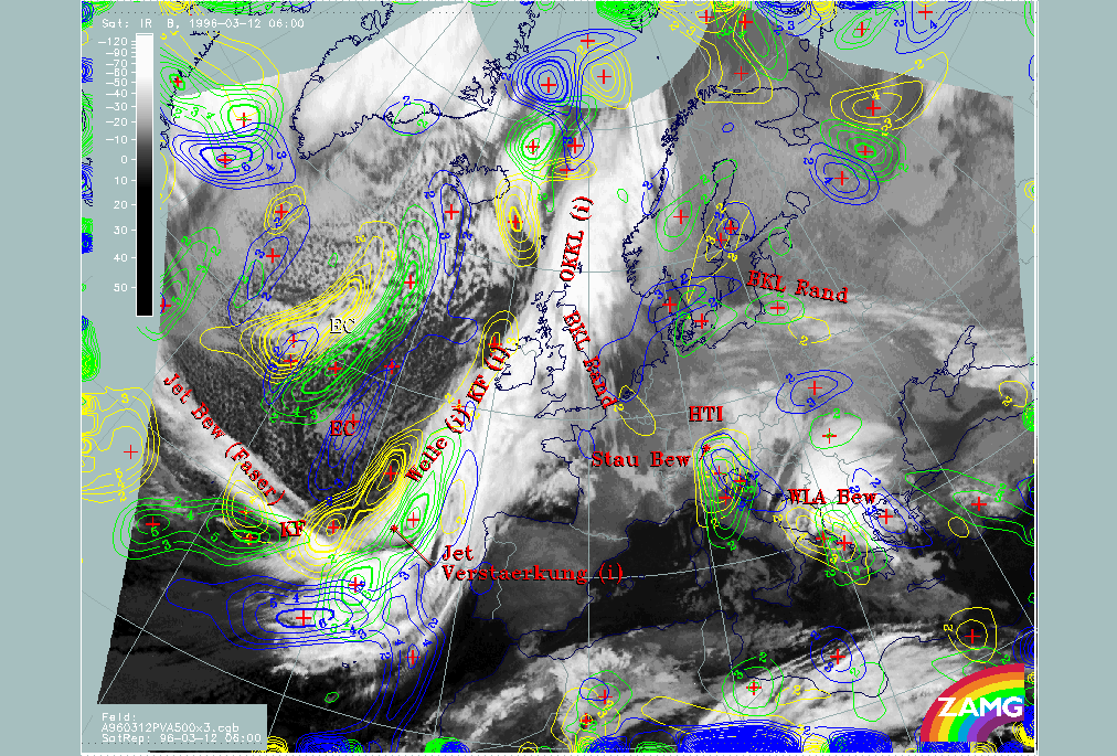
12 March 1996/06.00 UTC - Meteosat IR image; yellow: positive vorticity advection (PVA) 500 hPa 06.00 UTC, green: positive vorticity
advection (PVA) 500 hPa 12.00 UTC, blue: positive vorticity advection (PVA) 500 hPa 18.00 UTC; SatRep overlay: names of conceptual
models
|
|
|
There is a distinct displacement of the elongated PVA lobe at 500 hPa to the south-west, but on the other hand also a continuing elongation of the lobe can be observed; consequently it is not so easy to forecast the maximum of EC cloudiness in relation to the forecast EC lobe. In the 06.00 UTC image the EC is more connected with the southern maximum of PVA, therefore this propagation will be of most interest. For 18.00 UTC the elongated lobe is split into two maxima: one in the south, which should be the relevant one for the forecast of the EC in the 06.00 UTC image, and another one in the north close to Iceland.
|
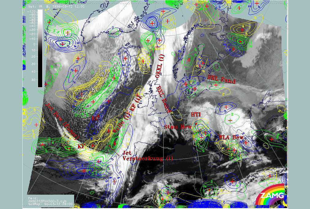
12 March 1996/12.00 UTC - Meteosat IR image; yellow: positive vorticity advection (PVA) 500 hPa 06.00 UTC, green: positive vorticity
advection (PVA) 500 hPa 12.00 UTC, blue: positive vorticity advection (PVA) 500 hPa 18.00 UTC; SatRep overlay: names of conceptual
models
|
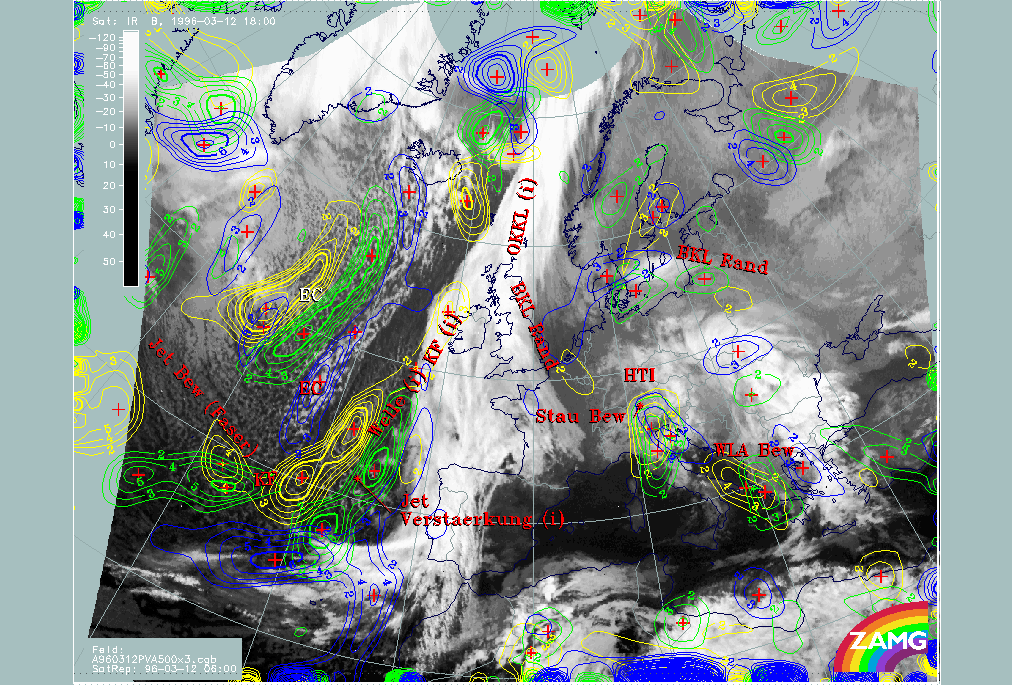
12 March 1996/18.00 UTC - Meteosat IR image; yellow: positive vorticity advection (PVA) 500 hPa 06.00 UTC, green: positive vorticity
advection (PVA) 500 hPa 12.00 UTC, blue: positive vorticity advection (PVA) 500 hPa 18.00 UTC; SatRep overlay: names of conceptual
models
|
|
|
The images of 12.00 and 18.00 UTC overlaid by the PVA maxima forecast show a perfect correspondence between the PVA field and the cloudiness. A decrease of cloudiness between 12.00 and 18.00 UTC can be recognized.
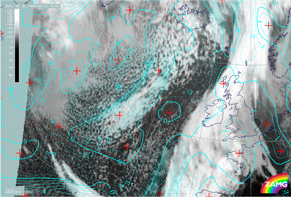
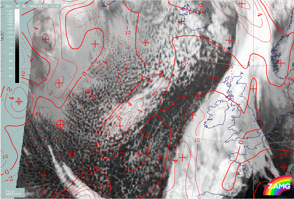
As shown for 06.00 UTC (compare Enhanced Cumulus ) the second, warmer EC cloud could only be explained with help of the complete field of VA at 500 as well as at 300 hPa; consequently they are superimposed also on the 12.00 UTC image. Both levels still contain this secondary relative maximum, but weakened in comparison to 06.00 UTC. The rest of the cloudiness of this second EC can be found in the region of the secondary PVA maxima. By 18.00 UTC the phenomenon has disappeared.
|
12 March 1996/12.00 UTC - Meteosat IR image; cyan: positive vorticity advection (PVA) 500 hPa
|
12 March 1996/12.00 UTC - Meteosat IR image; red: positive vorticity advection (PVA) 300 hPa
|
|
|
So this case study is a good example for three characteristics:
- There is excellent correspondence between EC cloudiness and PVA maxima, indicating the importance of the PVA field as a key parameter for the physical processes being described by this conceptual model;
- There is an excellent forecast of the PVA maxima;
- There is some indication about the possibility of a forecast of EC dissolution from the intensity difference between the two EC areas as well as from the intensity decrease in the forecast. But this latter point is more difficult to use because there are no thresholds of PVA weakening that could be used for a decision about a probable weakening of such a phenomenon.