18 - 19 February 1996 - Cold Front
|
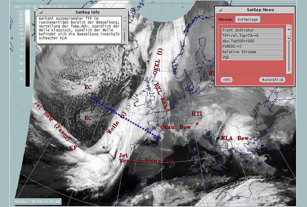
12 March 1996/06.00 UTC - Meteosat IR image; SatRep overlay: names of conceptual models, SatRep menu: key parameters for Cold Front,
position of vertical cross section indicated
|
|
|
For the diagnosis of the physical state of the Cold Front, a couple of key parameters and useful key parameter combinations are available which were chosen with respect to the conceptual model (for more information compare Conceptual Models: Cold Front ).
| Front Indicator | This is a line indicating the maximum of the thermal front parameter (TFP) 500/850 hPa (*10-1Km-1) |
|---|---|
| TFP + rel.Top + TA>=0 | This is a combination of the thermal front parameter (TFP) greater than 3 units, the equivalent thickness (rel.Top) 500/850 hPa (K) and warm advection (TA>=0) (K 12h-1); this combination of key parameters is especially indicative of the thermal characteristics of a Cold Front |
| TFP + Scher300=0 | This is a combination of the thermal front parameter (TFP) 500/850 hPa greater than 3 units and the zero line of shear vorticity at the 300 hPa level (Scher300=0); this combination of key parameters is indicative of the relation between front and jet stream |
| Abs.Top500 + 1000 | This is the combination of height contours at 1000 and 500 hPa (gpm); this combination of key parameters is indicative of the stream and pressure distribution near the surface and in the middle of the troposphere |
| PVA500>=2 | This parameter shows maxima of positive vorticity advection (PVA) at 500 hPa exceeding 2 units (*10-9sec-2); this key parameter indicates areas with increased possibility for more severe weather events because of increased vertical motion (compare Conceptual Models: Wave and Conceptual Models: Front Intensification by Jet Crossing ) |
| Relative Stroeme (relative streams) | This parameter shows relative streams on isentropic surfaces; relative streams are indicative of the different air masses involved in the process and of areas with sinking or rising motion; they can be used to explain cloud configurations requiring special explanation |
| VQS | Gives the location of available vertical cross sections (VQS) |
|
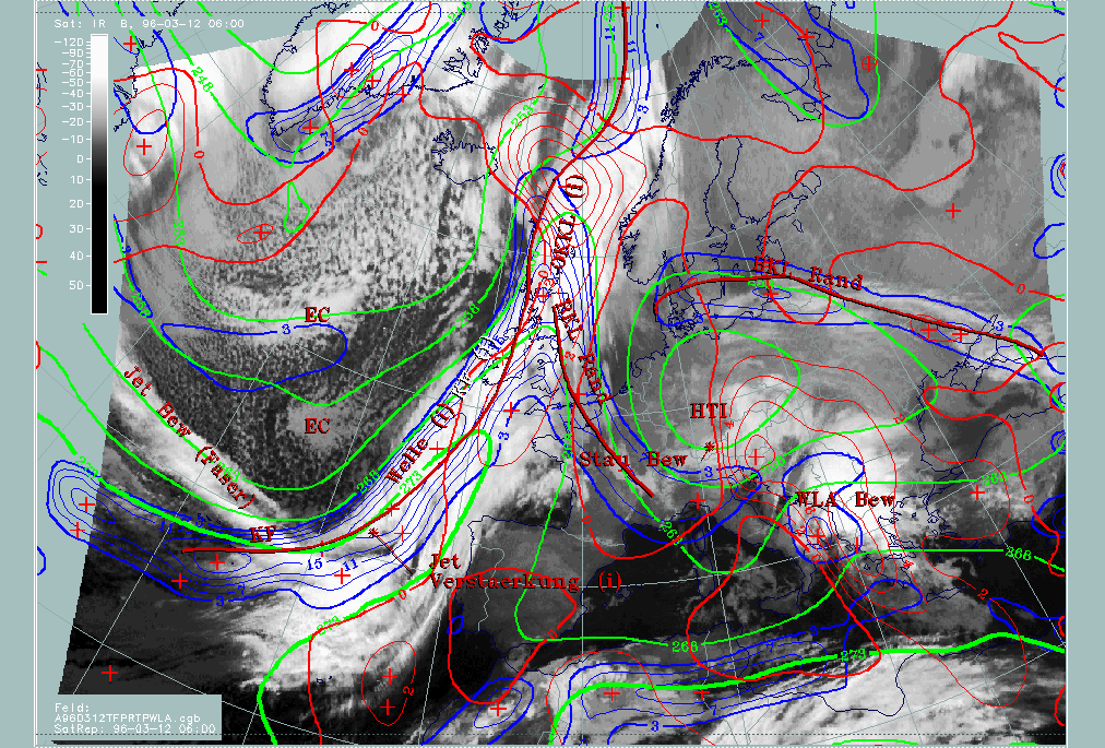
12 March 1996/06.00 UTC - Meteosat IR image; red thick: front indicator, blue: thermal front parameter (TFP) 500/850 hPa, green:
equivalent thickness 500/850 hPa, red: temperature advection - WA 1000 hPa, SatRep overlay: names of conceptual models
|
|
|
The TFP (thick red line) is ahead of a zone of high thickness gradients and close to the rear side of the cloud band, except for the Wave area where the typical cloud bulge exists. Over the Atlantic south of the Wave, the cloud band is under the influence of CA with the zero line of temperature advection close to the leading edge of the cloud band; north of the wave over Scotland the zero line accompanies the rear edge of the cloud band which therefore undergoes WA. So, concerning temperature advection, there are two different stages in the Cold Front separated by a Wave area. The southern part could also be diagnosed as a Cold Front in CA.
|
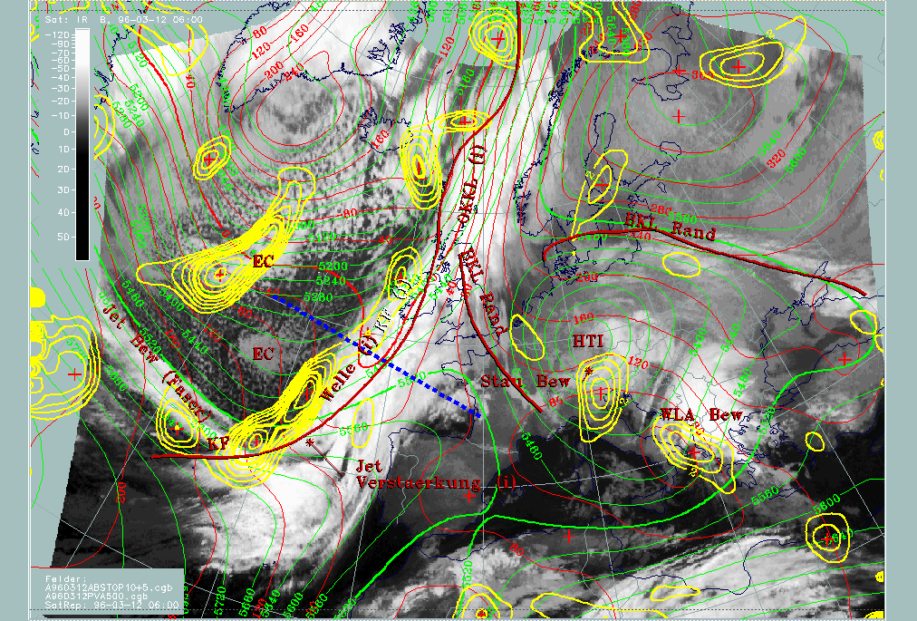
12 March 1996/06.00 UTC - Meteosat IR image; red thick: front indicator, red: height contours 1000 hPa, green: height contours 500 hPa,
yellow: positive vorticity advection (PVA) 500 hPa, position of vertical cross section indicated
|
|
|
Height levels at 1000 hPa (red) and 500 hPa (green) show a well-developed frontal situation with a pronounced small scale surface trough indicating the surface frontline. A broader upper level trough with two superimposed small scale troughs is situated at the rear side of the frontal cloud band. Of the latter, the eastern one can be localized immediately behind the Cold Front cloud band, the western one in the area of Enhanced Cumuli ("EC").
Yellow isolines enclose maxima of PVA at 500 hPa and show the high values close to the rear edge, especially in connection with the southern part of the cloud band. This situation will be discussed in detail in the special investigation (compare Diagnosis for 12 March 06.00 UTC ). Another dominant area is connected with the EC over the Atlantic and will be discussed as a separate conceptual model (compare Enhanced cumulus ).
Another important tool for a deeper diagnosis of the Cold Front structure is vertical cross sections. In the first satellite image in this part the vertical cross section has been superimposed as a section line. It is in the region of the Wave bulge.
|
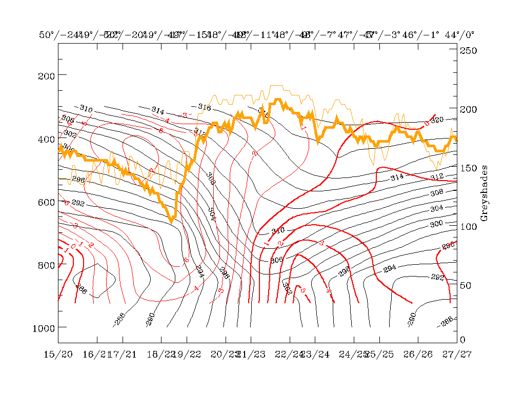
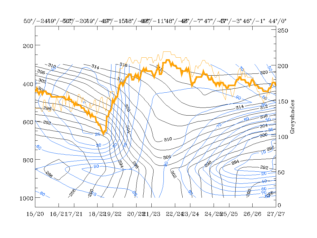
12 March 1996/06.00 UTC - Vertical cross section; black: isentropes (ThetaE), red thick: temperature advection - WA, red thin:
temperature advection - CA, orange thin: IR pixel values, orange thick: WV pixel values
|
12 March 1996/06.00 UTC - Vertical cross section; black: isentropes (ThetaE), blue: relative humidity, orange thin: IR pixel values,
orange thick: WV pixel values
|
|
|
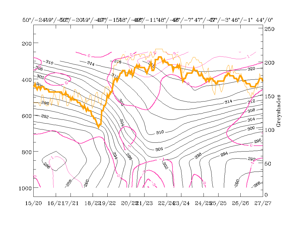
The isentropes (black lines in the first three panels) show a pronounced zone of high gradients typical for frontal situations. However, because of the location of the cross section line in the area of a Wave bulge, the configuration is a bit more complex and has to be explained in more detail. There is a broad zone of high gradients on the western (left) boundary of the cross section between approximately 650 and 300 hPa which is inclined downwards to the ground surface. The 302K isentropic surface reaches the latter at gridpoint 21/23 at about 49N/11W, a point which is approximately in the middle of the cloud band in the main part of the cloud bulge of the Wave. A second branch within this broad zone of high gradients is bound by the 304 - 310K isentropes and does not reach the ground surface. Instead, it forms a trough with an eastern branch inclined upward again. This is a synoptic situation typical for a Warm Front having no distinct surface front.
This configuration seems to be the consequence of the Wave area existing there and is confirmed by the other parameters to a certain extent. Humidity, for instance, contains high values of more than 90% reaching up to 500 hPa immediately ahead of the surface Cold Front and within and east of the trough in the isentropes and the Wave area. In contrast to this there is a steep gradient of humidity at about 49N/15W which coincides quite well with the western edge of the cloud band. This configuration has some similarities to the Kata Front type (compare Conceptual Models: Cold Front - Meteorological physical background ) where humidity and consequently cloudiness is ahead of the frontal surface, as opposed to the Ana Front type where it is inclined backwards on top of the frontal surface.
Looking at the vertical distribution of temperature advection, one can note a rather untypical situation, especially for the existence of a Wave: warm advection can only be found in front of the surface layer of the Cold Front and the Wave up to about 700 - 650 hPa, while above, there is pronounced cold advection. This would lead to the conclusion that Wave development is going on only in the lowest part of the troposphere and two different regimes are existing in two different layers, one on top of the other. Usually, such a vertical distribution with air becoming warmer in the lower layers but colder in the layers above is indicative of an unstable atmosphere. The character of cloudiness in the satellite images confirms this conclusion and, although not provable because of the location over the sea, convective weather events can be expected there.
|
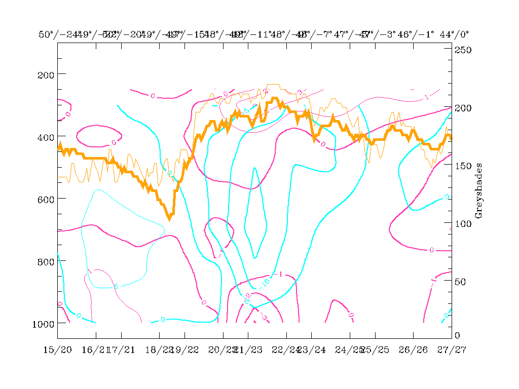
12 March 1996/06.00 UTC - Vertical cross section; black: isentropes (ThetaE), magenta thin: divergence, magenta thick: convergence,
orange thin: IR pixel values, orange thick: WV pixel values
|
12 March 1996/06.00 UTC - Vertical cross section; black: isentropes (ThetaE), magenta thin: divergence, magenta thick: convergence, cyan
thick: vertical motion (omega) - upward motion, cyan thin: vertical motion (omega) - downward motion, orange thin: IR pixel values,
orange thick: WV pixel values
|
|
|
The latter conclusion is also supported by two further parameters: divergence and vertical motion. There is a zone of convergence connected with the Cold Front surface with a primary maximum from the surface up to about 850 hPa and a secondary maximum around 700 hPa. As convergence and vertical motion are connected to each other via the Richardson equation, it is not surprising that maxima of upward motion exist on top of the maxima of convergence. This leads to a very typical distribution of the zone of convergence within the frontal zone, and a zone of upward motion on top of the frontal zone connected with cloudiness (compare, Conceptual Models: Cold Front - Typical appearance in vertical cross sections ). Nevertheless, in this case the intensity of vertical motion, especially in the Wave area, is extremely high, in accordance with the appearance of cloudiness there.