18 - 19 February 1996 - Intensification Of Cold Front Through Jet Streak Crossing
|
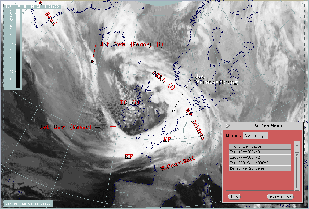
18 February 1996/06.00 UTC - Meteosat IR image; SatRep overlay: names of conceptual models; SatRep menu: key parameters for Jet
Intensification
|
|
|
This part of the cloud band lies over the North Sea and differs in its appearance from the rest of the Cold Front band; while the latter is relatively homogeneous, the former has much more structure in the form of cells. Unfortunately, weather activity cannot be proved because of its position over the sea.
Such areas very often are the result of the interaction of frontal circulation and cross circulation in the exit region of a jet streak which approaches and finally crosses the front (compare Conceptual Models: Front Intensification by Jet Crossing - Meteorological physical background ). Therefore the following key parameters and their combinations are regarded as relevant:
| Front Indicator | This is a line indicating the maximum of the thermal front parameter (TFP) 500/850 hPa (*10-1Km-1) |
|---|---|
| Isot + PVA300>=3 | This is a combination of isotachs greater than 30 units (m sec-1 and positive vorticity advection (PVA) at 300 hPa exceeding 3 units (*10-5) sec-2 |
| Isot + PVA300>=2 | This is a combination of isotachs greater than 30 units (m sec-1 and positive vorticity advection (PVA) at 500 hPa exceeding 2 units (*10-9) sec-2); both parameter combinations locate the exit region and the PVA maximum in relation to the frontal cloud band |
| Isot300 + Scher300=0 | This parameter combination shows the isotachs greater than 30 units (m sec-1) and the zero line of shear vorticity which marks the jet axis at 300 hPa; one can get information about the existence and strength of jet streaks and the course of the jet axis |
| Relative Stroeme (relative streams) | This parameter shows relative streams on isentropic surfaces; relative streams are indicative of the different air masses involved in the process and of areas of sinking or rising motion; they can be used to explain cloud configurations requiring special explanation |
|
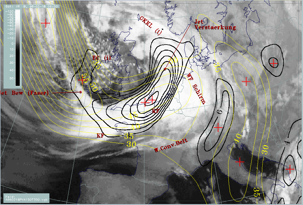
18 February 1996/06.00 UTC - Meteosat WV image; red: front indicator, yellow: isotach 300 hPa, black: positive vorticity advection
(PVA) 300 hPa, SatRep overlay: names of conceptual models
|
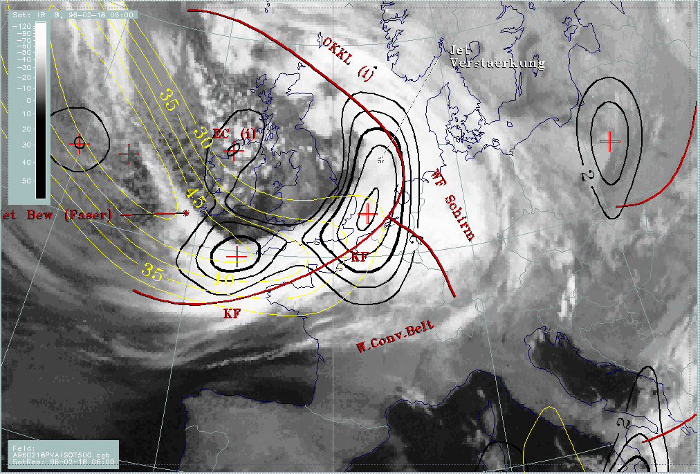
18 February 1996/06.00 UTC - Meteosat WV image; red: front indicator, yellow: isotach 500 hPa, black: positive vorticity advection
(PVA) 500 hPa, SatRep overlay: names of conceptual models
|
|
|
The two images show at 500 as well as at 300 hPa two pronounced jet streaks; the more extended one reaches from the North Atlantic southward to the Cold Front cloud band that it crosses close to Cornwall. A smaller one is more pronounced at 300 hPa and is relatively parallel to the cloud band in the English Channel, crossing the band near the occlusion point over the Netherlands (compare Conceptual Models: Cold Front ).
With the main western jet streak, a separate strong PVA maximum is connected only at 500 hPa and can be found west of Cornwall superimposed on the frontal cloud band. But this maximum appears exactly within the jet axis and not in the left exit region. This configuration, as well as the lower height level, is typical for situations where curvature vorticity as a consequence of a pronounced trough is strong.
Another strong PVA maximum can be found over south-east England in both levels. The PVA maximum is also situated within the jet axis and indicates therefore pronounced cyclonic curvature. But there is a secondary maximum of PVA at both levels exactly over the North Sea and the cellular structured cloud part. Concluding from the relation of all parameters, this PVA maximum should be in the left exit region and therefore rather the consequence of shear vorticity. Unfortunately, its effect on weather events cannot be evaluated because of the lack of observational data over the sea.