Table of Contents
- I. Introduction and Conceptual Models for 18 February 1996 06.00 UTC
- II. Conceptual Models - Forecast for 18 February 1996 12.00 UTC and 18.00 UTC
- III. "Special Investigation": Formation of new Cold Front from Occlusion
Introduction and short case description
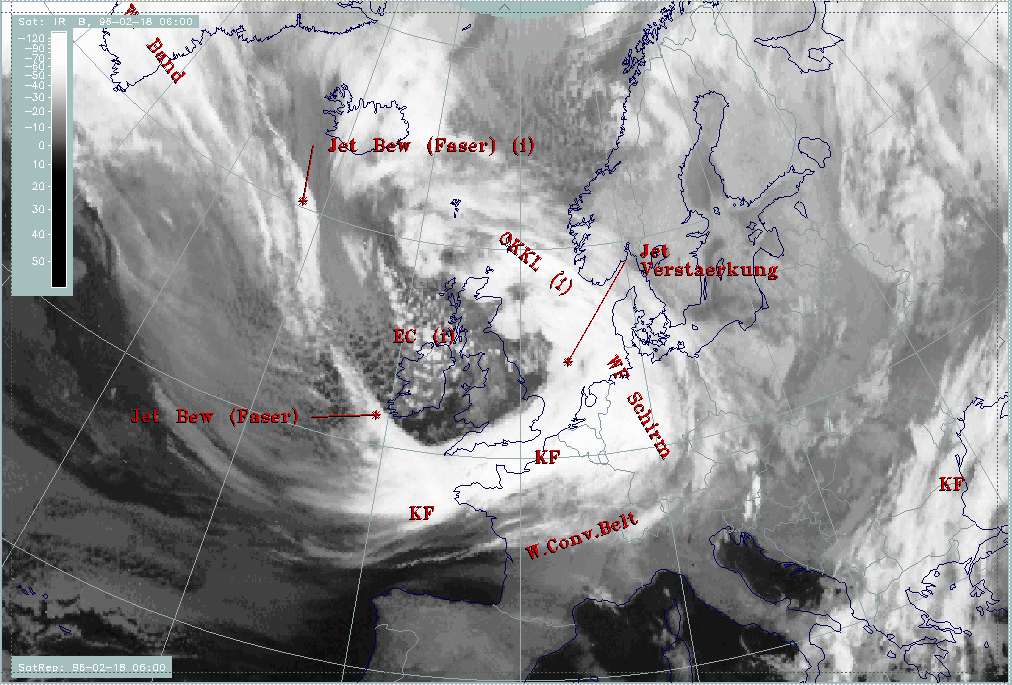
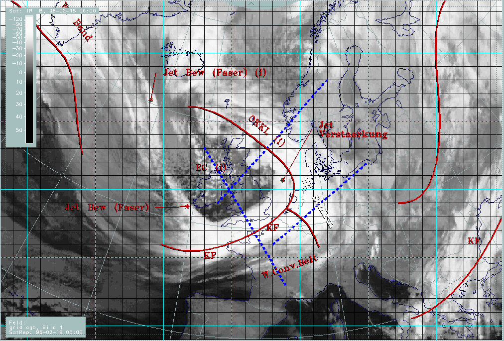
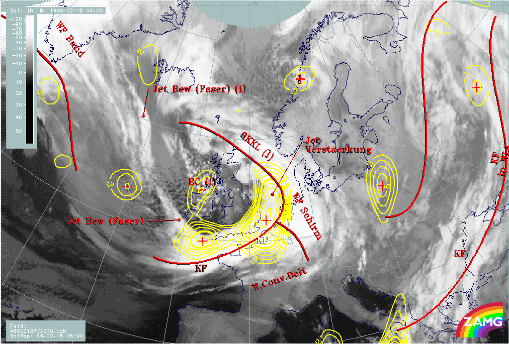
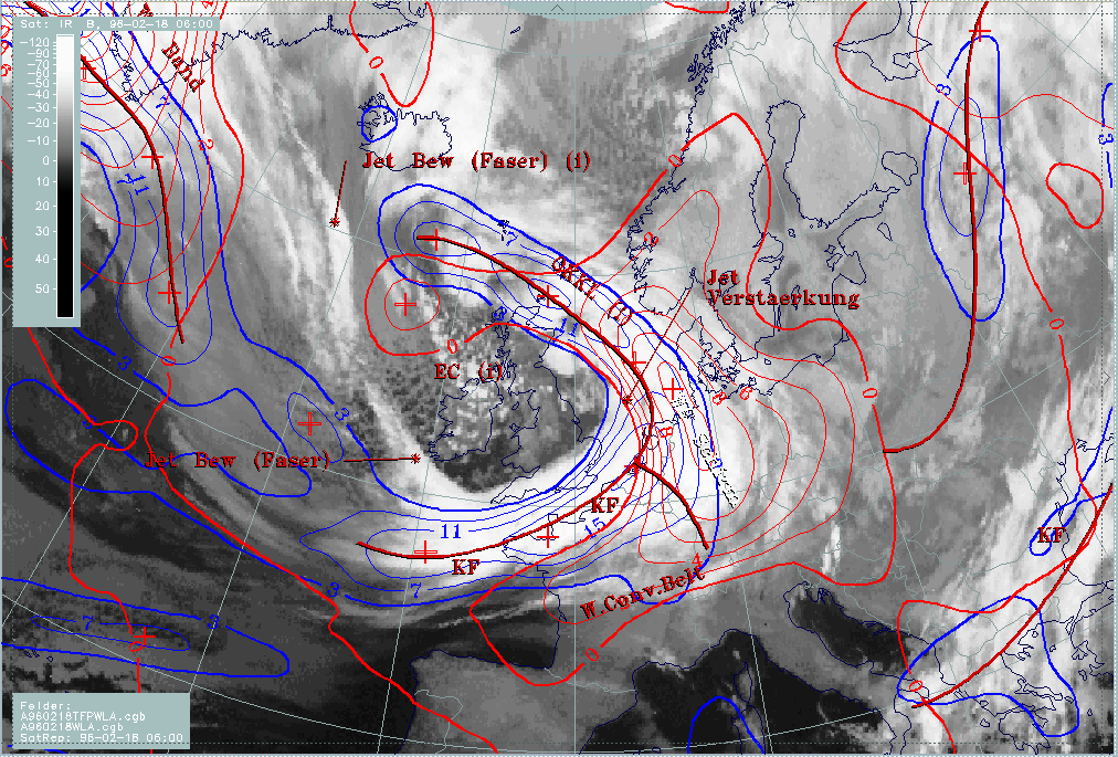
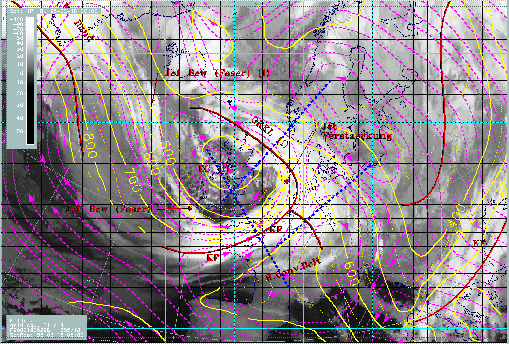
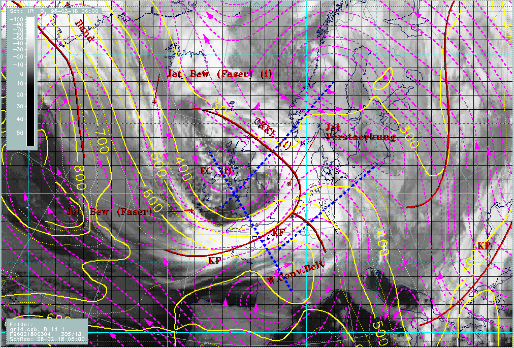
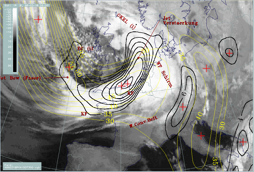
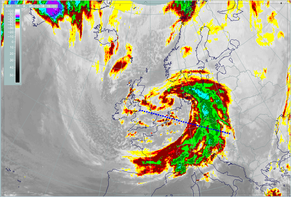
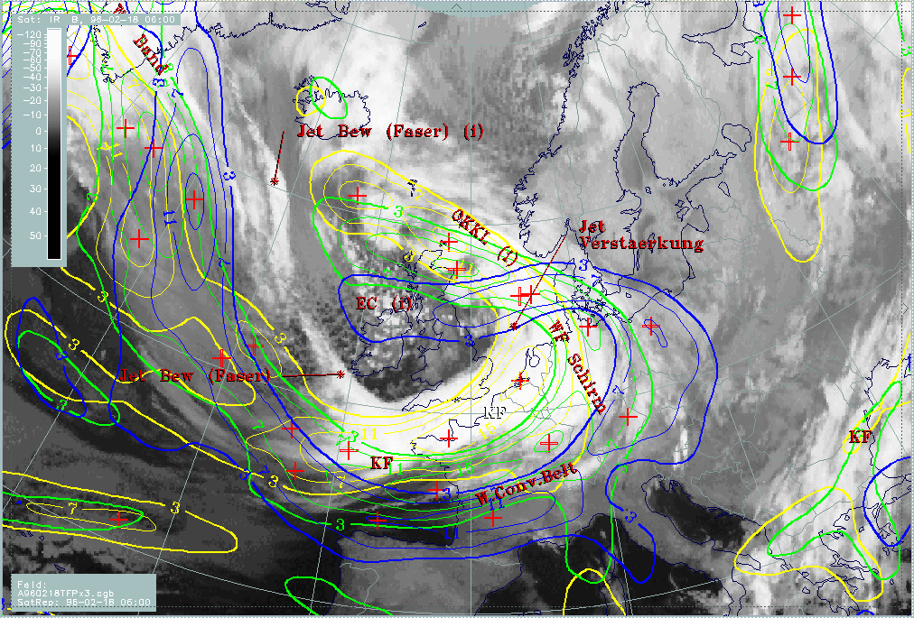
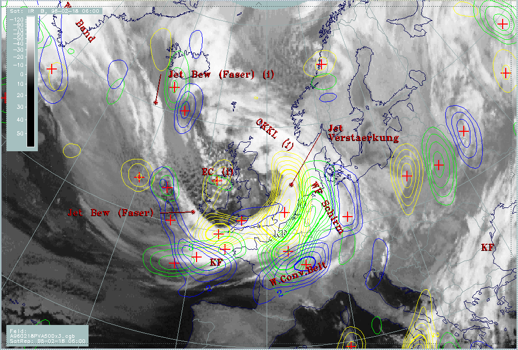
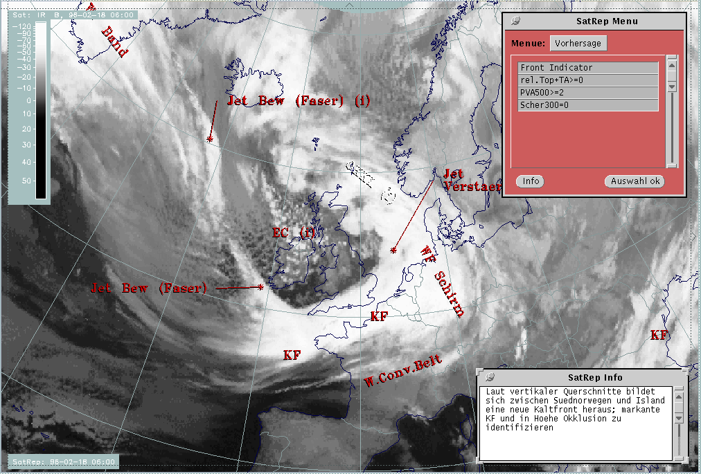
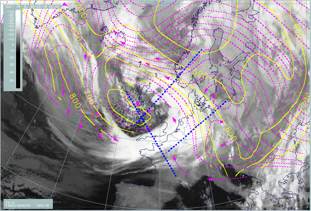
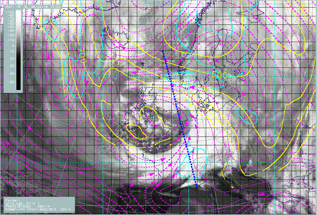
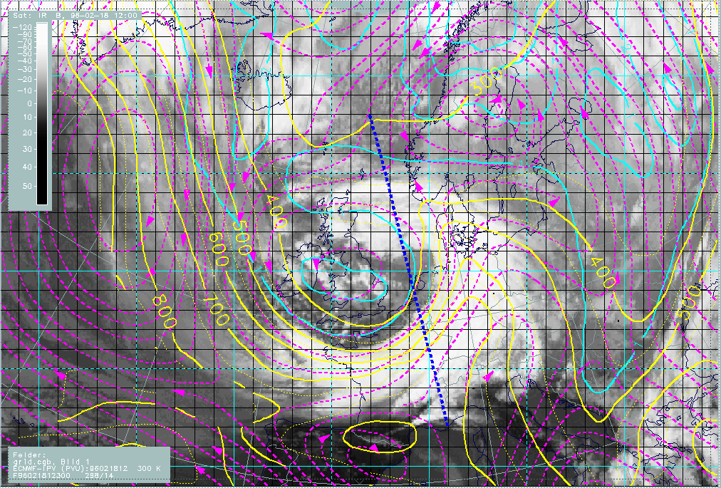
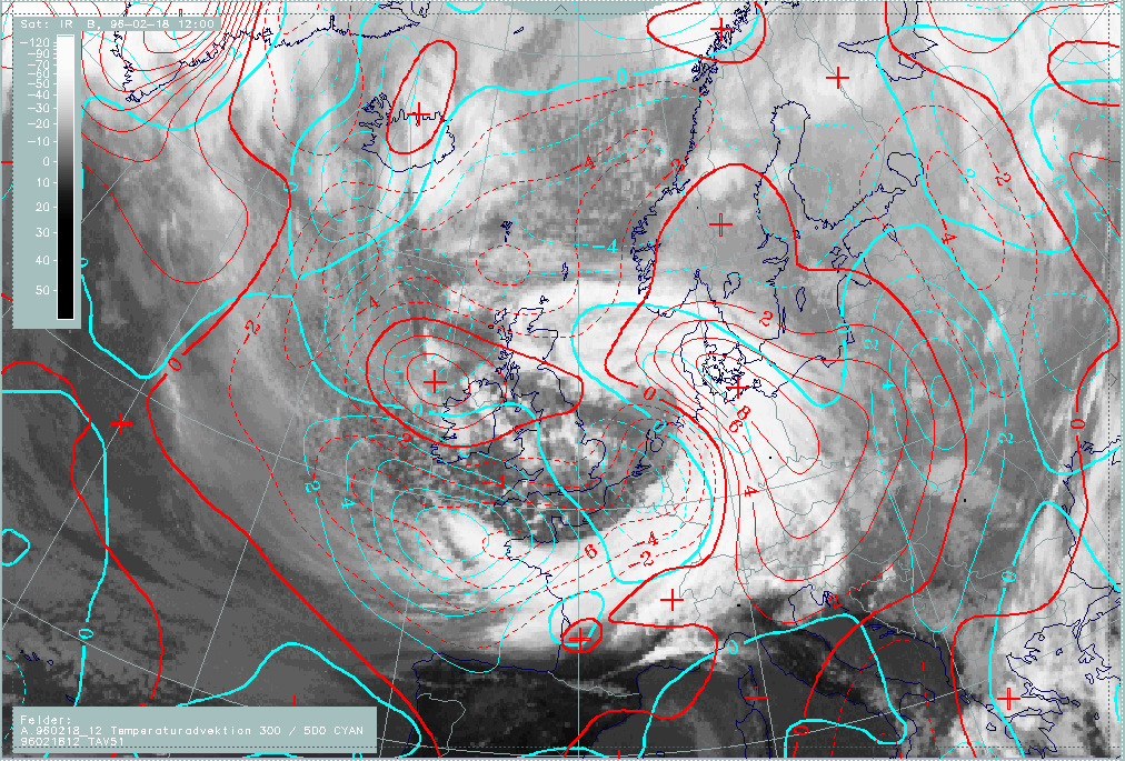
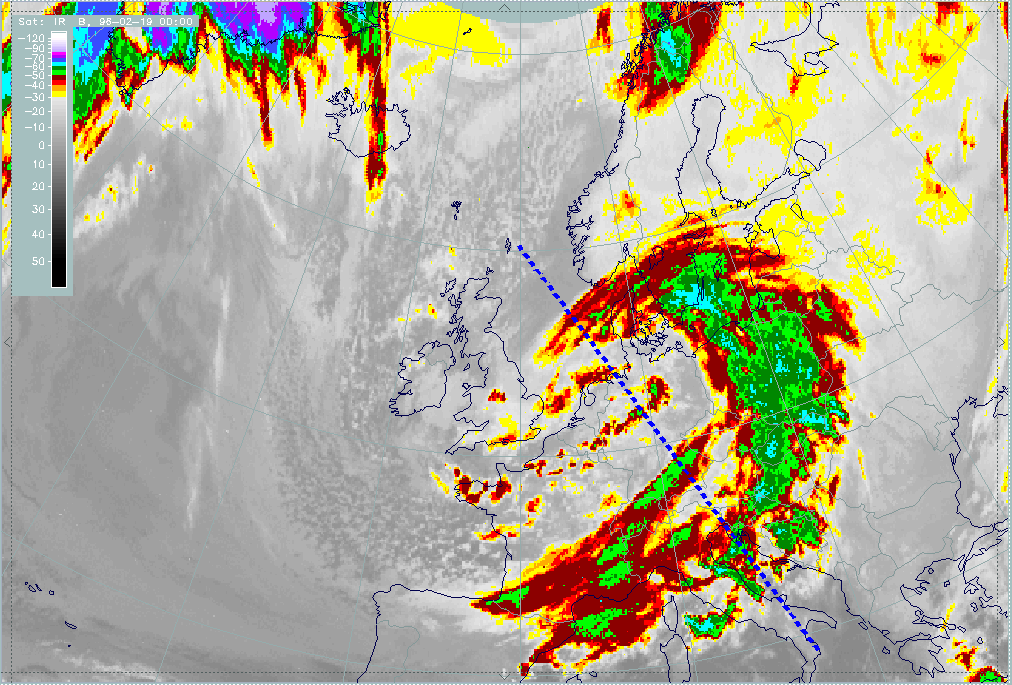
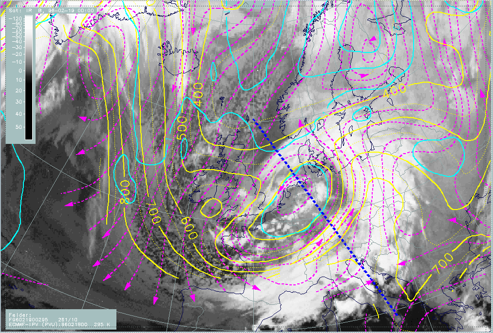
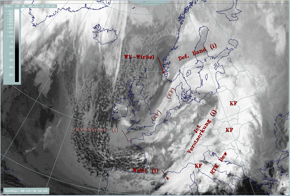
The cloud band of a frontal system stretches from the English Channel and adjacent countries across Belgium, the Netherlands and Germany into the North Sea. The cloudiness is widely accompanied by precipitation in the form of snow in the eastern parts (cyan crosses), in the form of rain west of it (green crosses).
Cloud fibres stretching from Greenland across the Atlantic (approximately 58N/20W) reach the frontal cloud band west of Cornwall (50N/06W). An angle is formed between the frontal cloudiness and the fibres which is typical for the crossing of frontal cloudiness by a jet stream/streak with the fibres indicating the jet axis (compare Cloud fibre at jet axis ).
Cellular cloudiness west of England and over Ireland indicates cold air with an EC or EC-like intensified area embedded (approximately 55N/09W).
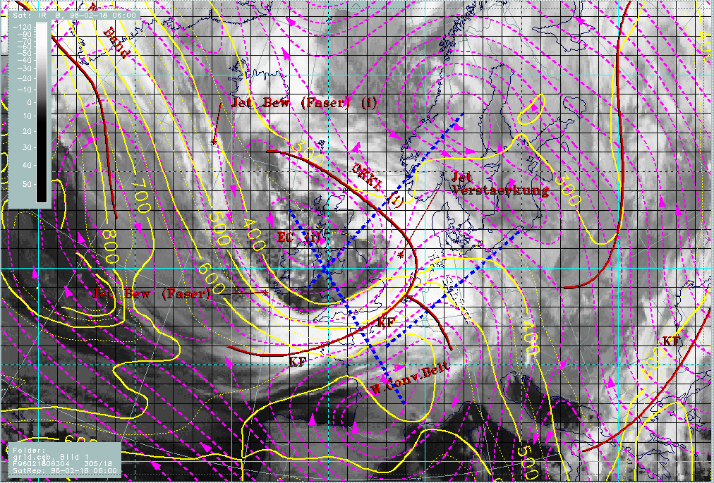
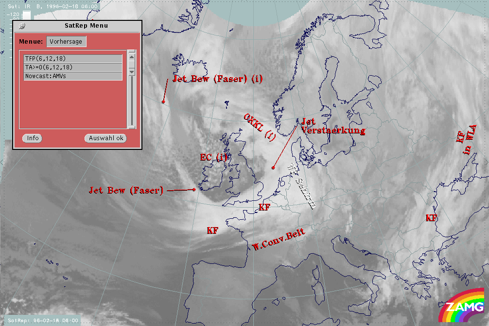
The next image shows the names of the conceptual models diagnosed within the SatRep (Satellite Report) and superimposed as a first level of SatRep on the satellite image:
- KF: Cold Front
- WF Schirm: Warm Front Shield
- OKKL: Occlusion
- Jet Verstaerkung: Jet intensification i.e. intensification of frontal cloudiness by jet streak crossing
- Jet Bew (Faser): Jet cloudiness (fibre) i.e. Cloud Fibres related to jet axis
|
18 February 1996/06.00 UTC - Meteosat IR image; SatRep overlay: names of conceptual models
|
|
|
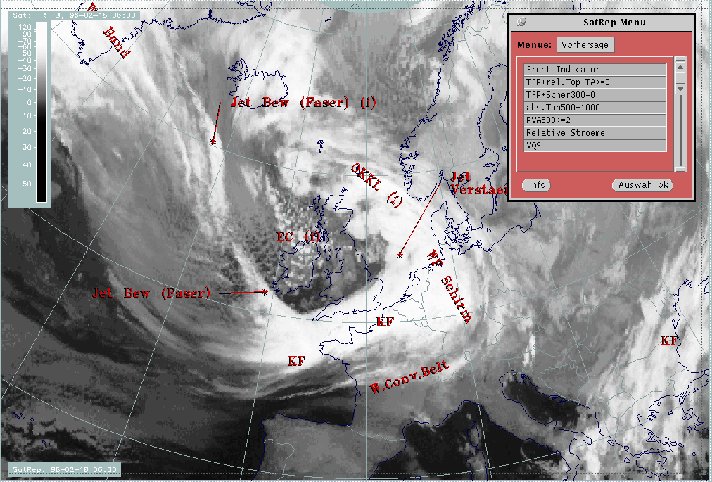
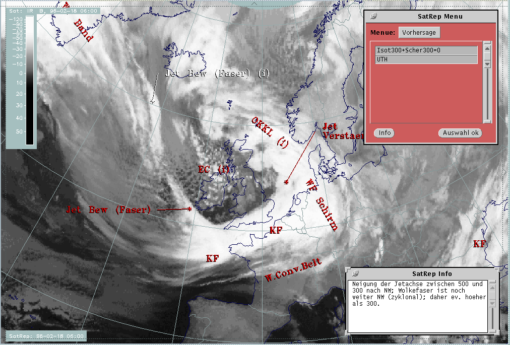
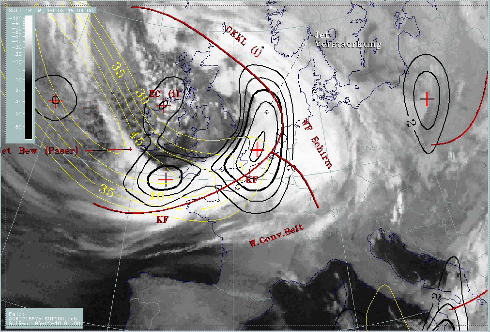
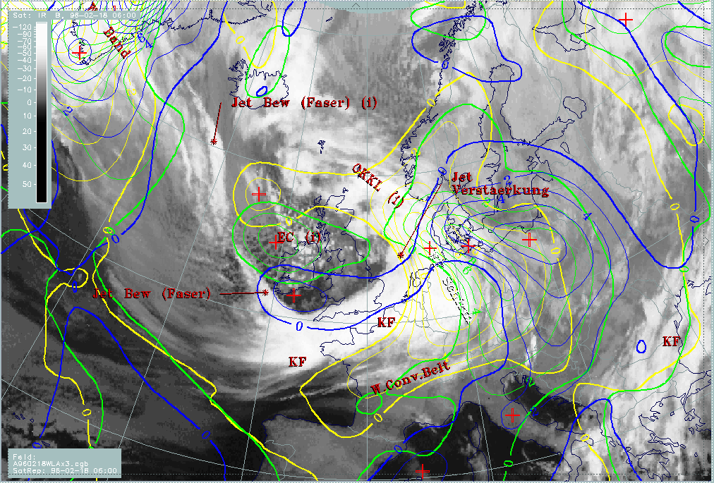
The second and third level of the SatRep show detailed information about the key parameters of the conceptual models as well as about the forecast.
18 - 19 February 1996 - Cold Front
|
18 February 1996/06.00 UTC - Meteosat IR image; SatRep overlay: names of conceptual models; SatRep menu: key parameters for Cold Front
|
|
|
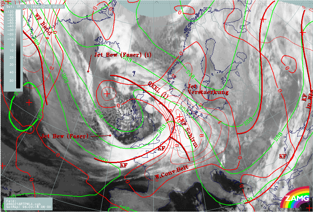
For the diagnosis of the physical state of the Cold Front, a couple of key parameters and useful key parameter combinations are available which were chosen with respect to the conceptual model (for more information compare Conceptual Models: Cold Front ).
| Front Indicator | This is a line indicating the maximum of the thermal front parameter (TFP) 500/850 hPa (*10-1Km-1) |
|---|---|
| TFP + rel.Top + TA>>=0 | This is a combination of the thermal front parameter (TFP) greater than 3 units, the equivalent thickness (rel.Top) 500/850 hPa (K) and warm advection (TA>=0) (K 12h-1); this combination of key parameters is especially indicative of the thermal characteristic of a Cold Front |
| TFP + Scher300=0 | This is a combination of the thermal front parameter (TFP) 500/850 hPa greater then 3 units and the zero line of shear vorticity at the 300 hPa level (Scher300=0); this combination of key parameters is indicative of the relation between front and jet stream |
| Abs.Top500 + 1000 | This is the combination of height contours at 1000 and 500 hPa (gpm); this combination of key parameters is indicative of the flow and pressure distribution near the surface and in the middle of the troposphere |
| PVA500>=2 | This parameter shows maxima of positive vorticity advection (PVA) at 500 hPa exceeding 2 units (*10-9sec-2); this key parameter indicates areas with increased possibility for more severe weather events because of increased vertical motion (compare Conceptual Models: Wave and Conceptual Models: Front Intensification by Jet Crossing ) |
| Relative Stroeme (relative streams) | This parameter shows relative streams on isentropic surfaces; relative streams are indicative of the different air masses involved in the process and of areas with sinking or rising motion; they can be used to explain cloud configurations requiring special explanation |
| VQS | Gives the location of available vertical cross sections (VQS) |
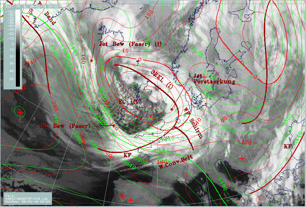
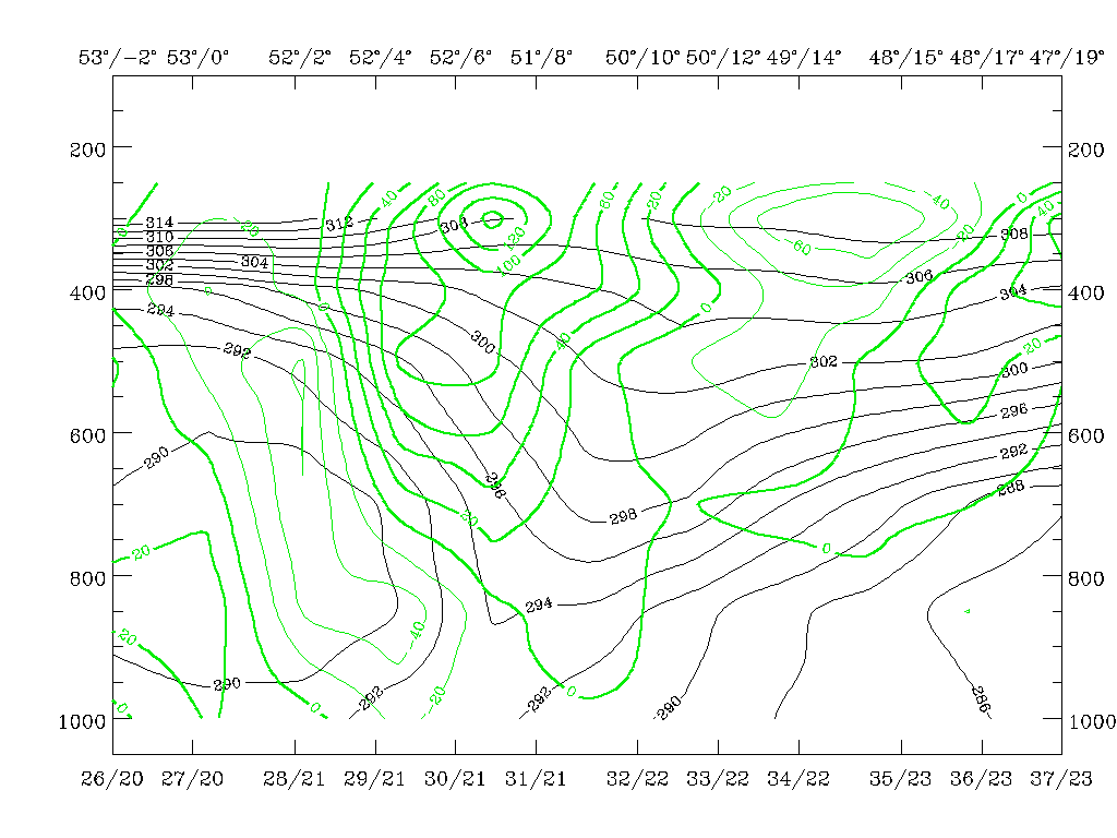
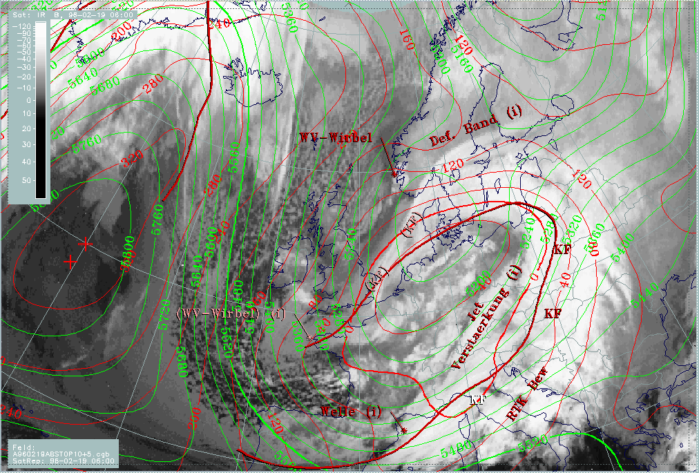
The Cold Front cloud band under consideration reaches from the Atlantic (approximately 38N/10W) across the English Channel into the North Sea approximately up to the Dutch coast. Cloudiness is rather homogeneous with only slightly lower tops at the rear side of the front.
|
18 February 1996/06.00 UTC - Meteosat IR image; red thick: front indicator, red: height contours 1000 hPa, green: height contours 500
hPa
|
|
|
To get an overview, the height contours at 1000 as well as at 500 hPa are interpreted. There is an already well-developed low with a vertical axis between surface and upper troposphere. This is an atypical situation, because in most cases a much earlier stage of development is investigated with a surface low and an upper level trough upstream. Therefore it could be expected that frontal systems connected with such a well-developed low are also in a well-developed stage, or may even be already in dissolution. As the investigations will show the contrary is the case; in particular the cold front represents a very clear example of an Ana Front type.
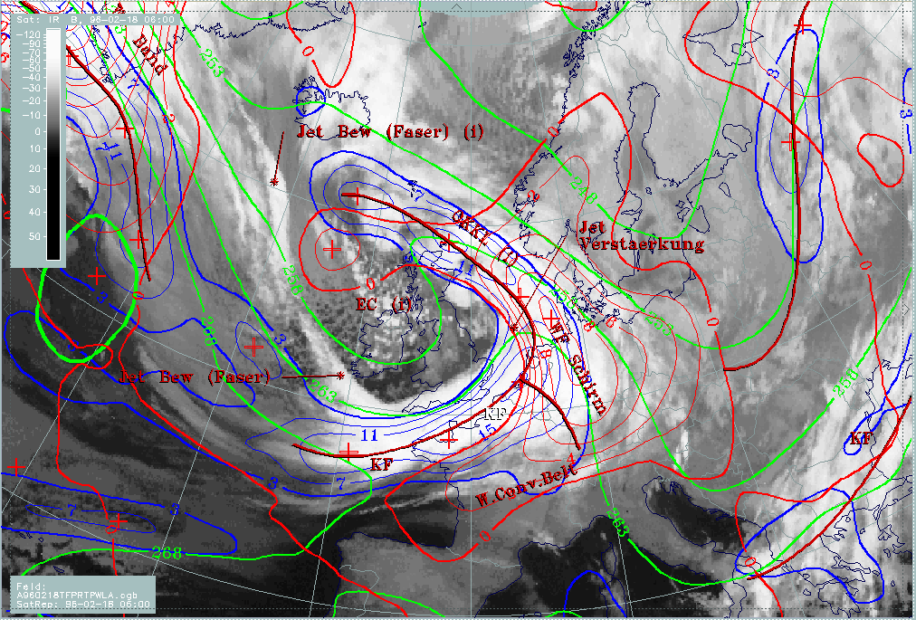
|
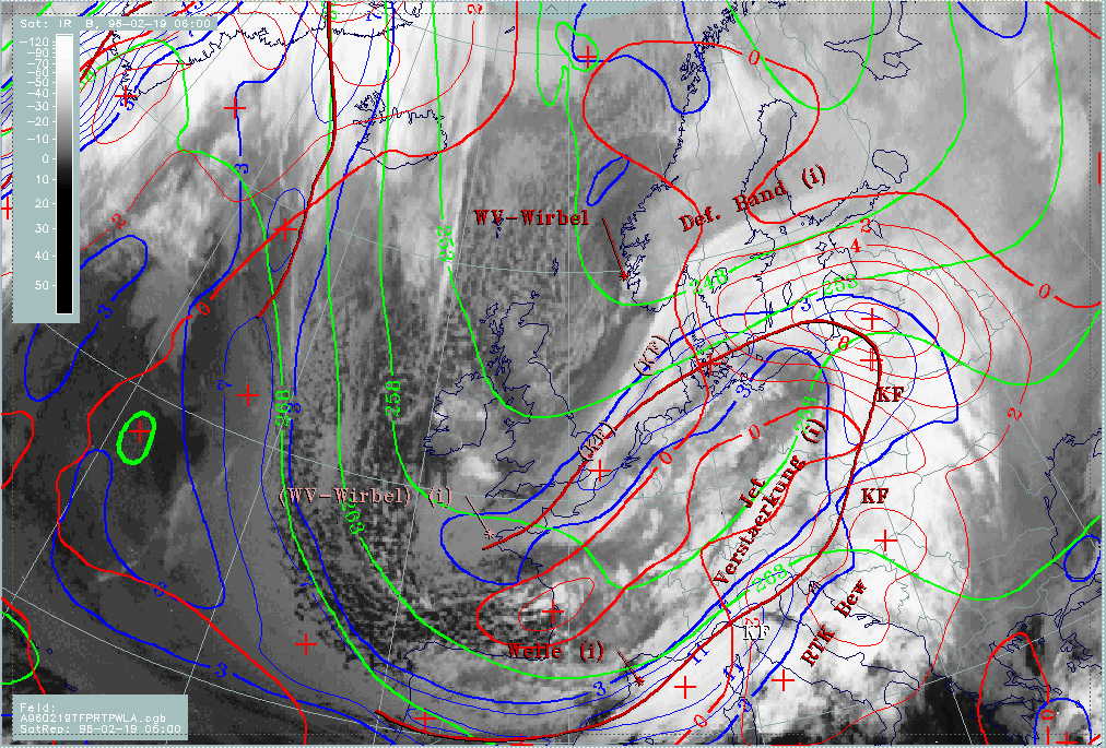
18 February 1996/06.00 UTC - Meteosat IR image; blue: thermal front parameter (TFP) 500/850 hPa, red thick: front indicator, green:
equivalent thickness 500/850 hPa, red: temperature advection - WA 500/1000 hPa
|
|
|
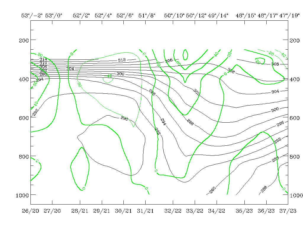
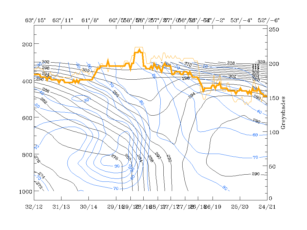
As a next very important step, the thermal frontal conditions should be investigated. The maximum line of the TFP indicated by the solid red line of the front indicator shows the position of the Cold Front, according to the definition that a surface Cold Front can be found where the temperature begins to sink. In the thickness field the zones of high gradients ("crowding zones" of isolines) are a typical characteristic for frontal conditions, representing the quick transition from warm (thick) to cold air (thin layer) at a weather front. Temperature advection (TA) changes its sign in the area of the front, for instance from warm advection (WA) in front of the cloud band to cold advection (CA) behind it. So the zero line of TA should be close to or within the cloud band.
In this case the solid line from the Atlantic across Brittany to the Belgian and Dutch coast, representing the front parameter and indicating the maximum of the TFP (blue lines), is close to the leading edge of the frontal cloud band; consequently the zone with high gradients in the thickness lines (green) can be found within and behind the frontal cloud band. Also the zero line of TA (thick red line) accompanies the leading edge of the frontal cloud band, at least over the land areas, leaving the main cold front cloudiness within CA.
The described appearance of key parameters and their relation to the cloud band is typical for an Ana Cold Front (compare Conceptual Models: Cold Front - Meteorological physical background ) where, because of a back bent Warm Conveyor Belt, the main cloudiness and precipitation events can be found behind the surface Cold Front. This conclusion can be supported by vertical cross sections as well as relative streams.
|
18 February 1996/06.00 UTC - Meteosat IR image; ECMWF grid superimposed, position of vertical cross section indicated
|
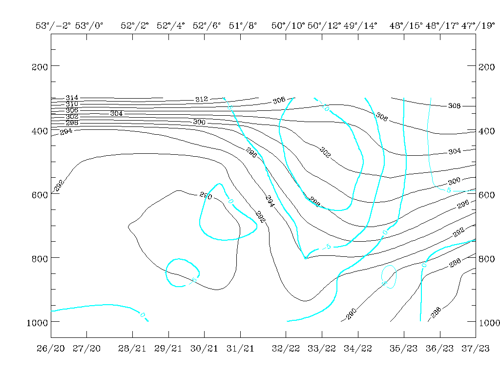
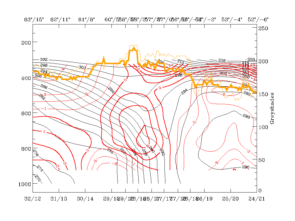
18 February 1996/06.00 UTC - Vertical cross section; black: isentropes (ThetaE), blue: relative humidity, orange thin: IR pixel values,
orange thick: WV pixel values
|
|
|
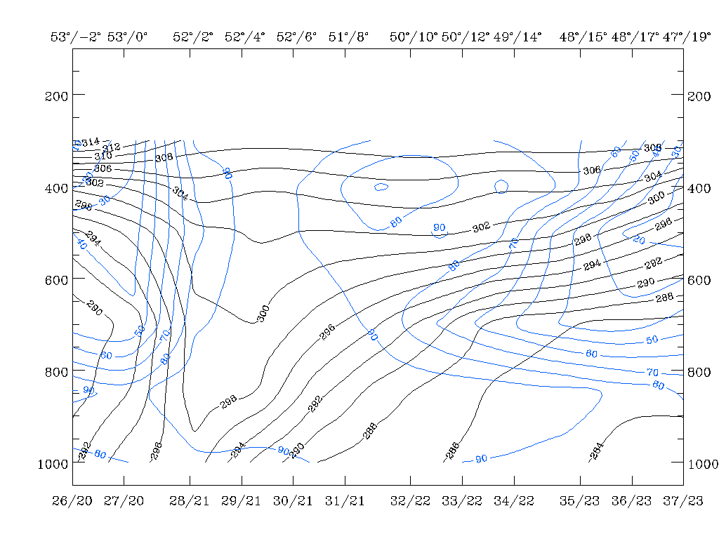
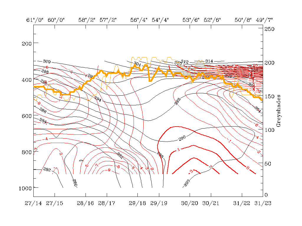
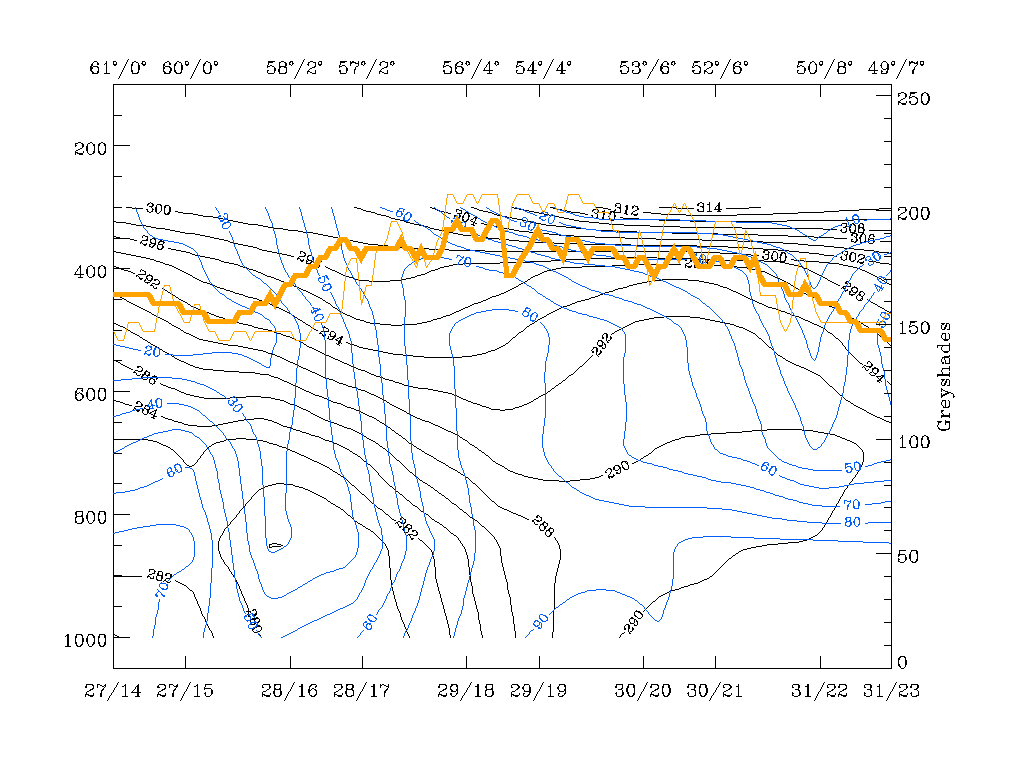
The black lines represent the equivalent potential temperature. The frontal surface is indicated by the crowding zone of isentropes which are inclined downward from approximately 450 - 400 hPa at 52N/03W to the surface at approximately 47N/00E. The orange lines represent the IR (thin) and WV (thick) pixel values, and it is clearly shown that the highest values are behind the surface front. The relative humidity (green) isolines give still more insight because it can be seen that the maxima of humidity are on top of the crowding zone reaching from the ground with values of 90% up to about 300 hPa with values of 50%. Very dry air (less than 10%) protruding downward can already be seen within the highest region of the frontal crowding zone. This is the explanation for the slightly lower cloud tops at the rear side of the Cold Front cloud band already mentioned with the cloud description.
|
18 February 1996/06.00 UTC - Vertical cross section; black: isentropes (ThetaE), red thick: temperature advection - WA, red thin:
temperature advection - CA, orange thin: IR pixel values, orange thick: WV pixel values
|
|
|
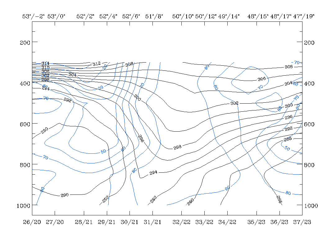
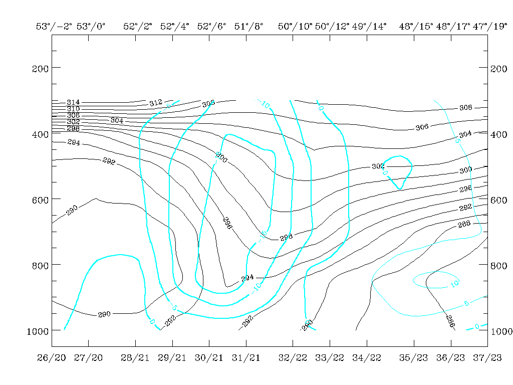
Temperature advection confirms that there is pronounced CA within the frontal crowding zone with the maximal values below it; in this special case CA also partly takes place in front of the frontal zone, especially in middle layers; WA in front of the frontal zone can only be found in the lowest and highest layers. This is not unusual for Ana Fronts but a rather strong example.
Two isentropic surfaces are selected for computation of relative streams: the lower surface is the Theta = 298K surface which is on top of the main frontal crowding zone and reaches from 400 hPa nearly down to the surface; the second is the Theta = 304K surface which represents the layer between 400 and 600 hPa and is a weak upper level front. On both surfaces relative streams are computed with a system velocity of 305° and 18 m/s. System velocities are determined with the help of cross correlation methods.
|
18 February 1996/06.00 UTC - Meteosat IR image; magenta: relative streams 298K - system velocity 305° 18m/s, yellow: isobars, ECMWF
grid superimposed, position of vertical cross section indicated
|
18 February 1996/06.00 UTC - Meteosat IR image; magenta: relative streams 305K - system velocity 305° 18m/s, yellow: isobars, ECMWF
grid superimposed, position of vertical cross section indicated
|

|
|
Both surfaces show the three main relative streams involved in frontal processes:
- The Warm Conveyor Belt, a relative stream from the region in front of the Cold Front; it originates in the Mediterranean and streams across Spain to west Europe and into the North Sea;
- A relative stream from behind the Cold Front but originating from more humid regions mostly in the north-west; it can be followed from south of Greenland across the Atlantic into the English Channel where it correlates with the cloud band;
- A relative stream from behind the Cold Front but originating from very dry areas mostly in the north and north-east which is often called dry intrusion; in this case it is involved in an already closed circulation over and north-west of the British Isles.
A main difference between the two levels in the region of the Cold Front can be seen in the transition area between the Warm Conveyor Belt and the wet relative stream from behind the Cold Front. In the lower level (298K) relative streams of the Warm Conveyor Belt cross the frontal line (which is approximately north-east of Normandy) and remain on the rear side. There the air rises from about 800 hPa up to about 600 hPa. In the higher level the Warm Conveyor Belt remains in front of and above the surface line. Comparing again with the vertical cross section, this is the humid air that reaches up to 600 hPa, with values of 60% - 90%.
The rest of the Cold Front cloud band is, in both levels, under the influence of the humid relative stream from behind the Cold Front with rising motion from 700 up to 400 hPa. The cloud edge of the Cold Front band is at both levels identical with the transition between the humid and the dry relative stream from the rear side of the Cold Front band. Comparing with the vertical cross section the humid relative stream can be identified with the maximum of more than 50% relative humidity on top of the 304K surface which is around 49N/00E, while the very low values north-west of it (around 52N/02W) indicate the dry intrusion. The whole situation is very typical for an ana front (compare Conceptual Models: Cold Front - Meteorological physical background ).
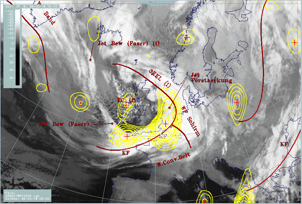
After the evaluation of the thermal characteristics of the Cold Front and of the air masses involved, parameters are discussed which can give some indications about the strength of the connected weather and cloudiness. Maxima of vorticity advection (PVA) superimposed on frontal cloudiness influence weather activity by contributing to upward motion. There are two points of view:
- PVA maxima indicating the approach and/or deepening of troughs; in these cases curvature vorticity is the dominant parameter and the 500 hPa level is a typical height to look at.
- PVA maxima indicating the approach of a jet streak; in these cases shear vorticity is the dominant parameter and the 300 hPa level is a typical height to look at.
|
18 February 1996/06.00 UTC - Meteosat IR image; red thick: front indicator, yellow: positive vorticity advection (PVA) 500 hPa
|
18 February 1996/06.00 UTC - Meteosat WV image; red thick: front indicator, blue: thermal front parameter (TFP) 500/850 hPa, yellow:
shear vorticity 300 hPa
|
|
|
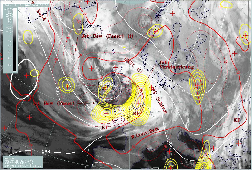
The PVA maximum at 500 hPa (yellow lines) is very pronounced, which means an active frontal system. At 300 hPa the zero line of shear vorticity (yellow) cuts the TFP (blue lines) approximately over the Netherlands giving room for two conclusions:
- According to classical definitions this could be the area of the transition from Cold Front to Occlusion (the Occlusion point).
- A PVA maximum at 300 hPa can be expected superimposed on the frontal cloudiness on the left side of the zero line; this leads to a different conceptual model: Intensification of frontal cloudiness by jet streak crossing (sub-menu) and will be investigated there.
18 - 19 February 1996 - Warm Front
|
18 February 1996/06.00 UTC - Meteosat IR image; SatRep overlay: names of conceptual models; SatRep menu: key parameters for Warm Front
|
|
|
For the diagnosis of the physical state of the Warm Front, a couple of key parameters and useful key parameter combinations are available which were chosen with respect to the conceptual model (for more information compare manual, Conceptual Models: Warm Front Band - Meteorological physical background or Conceptual Models: Warm Front Shield - Meteorological physical background ).
| Front Indicator | This is a line indicating the maximum of the thermal front parameter (TFP) 500/850 hPa (*10-1Km-1). |
|---|---|
| TFP + WLA | This is a combination of the thermal front parameter (TFP) 500/850 hPa greater than 3 units and warm advection (WA) 500/1000 hPa (K 12h-1); this combination of key parameters is especially indicative of the thermal characteristics of a Warm Front. |
| TA>=0 | This parameter shows maxima of warm advection; although already contained in TFP + WA, sometimes the necessity arises to look at this field separately. |
| Relative Stroeme | This parameter shows relative streams on isentropic surfaces; relative streams are indicative of the different air masses involved in the process and of areas of sinking or rising motion; they can be used to explain cloud configurations not normally encountered. |
| VQS | Gives the location of available vertical cross sections (VQS) |
The IR satellite image shows a cloud shield over the Netherlands and western Germany without any significant structure; the WV image contains a notable Dark Stripe at the leading eastern cloud edge. This dry air appears typically at that position and marks the cyclonic side of the jet axis accompanying the Warm Front cloud edge (compare Cloud fibre at jet axis ).
|
18 February 1996/06.00 UTC - Meteosat WV image; SatRep overlay: names of conceptual models
|
18 February 1996/06.00 UTC - Meteosat IR image; blue: thermal front parameter (TFP) 500/850 hPa, red thick: front indicator, red:
temperature advection - WA 1000 hPa
|
|
|
The key parameter combination of TFP (blue) and WA (red) is typical for a Warm Front accompanied by a cloud shield. As is very often the case with Warm Fronts, the maximum of the TFP which identifies the frontal line cannot be identified by closed isolines but only by a trough-like feature. A warm advection maximum is in front of the TFP and the front indicator (thick red line), being the main reason for the development of the Warm Front cloudiness. In this case WA extends across the frontal line into the area of the warm sector. This is typical for a Warm Front accompanied by a cloud shield, in contrast to a Warm Front accompanied by a cloud band (compare Conceptual Models: Warm Front Band or Conceptual Models: Warm Front Shield ).
Explanations for these typical structures can be found by looking at vertical cross sections and relative streams, especially the "Warm Conveyor Belt".
|
18 February 1996/06.00 UTC - Meteosat IR image; ECMWF grid superimposed, position of vertical cross section indicated
|
|

|
The vertical cross section relevant for the warm front extends from France (approximately 48N/01E) across Belgium and Germany to the coastline of Poland (approximately 54N/18E).
|
18 February 1996/06.00 UTC - Vertical cross section; black: isentropes (ThetaE), blue: relative humidity, orange thin: IR pixel values,
orange thick: WV pixel values
|
18 February 1996/06.00 UTC - Vertical cross section; black: isentropes (ThetaE), red thick: temperature advection - WA, red thin:
temperature advection - CA, orange thin: IR pixel values, orange thick: WV pixel values
|
|
|
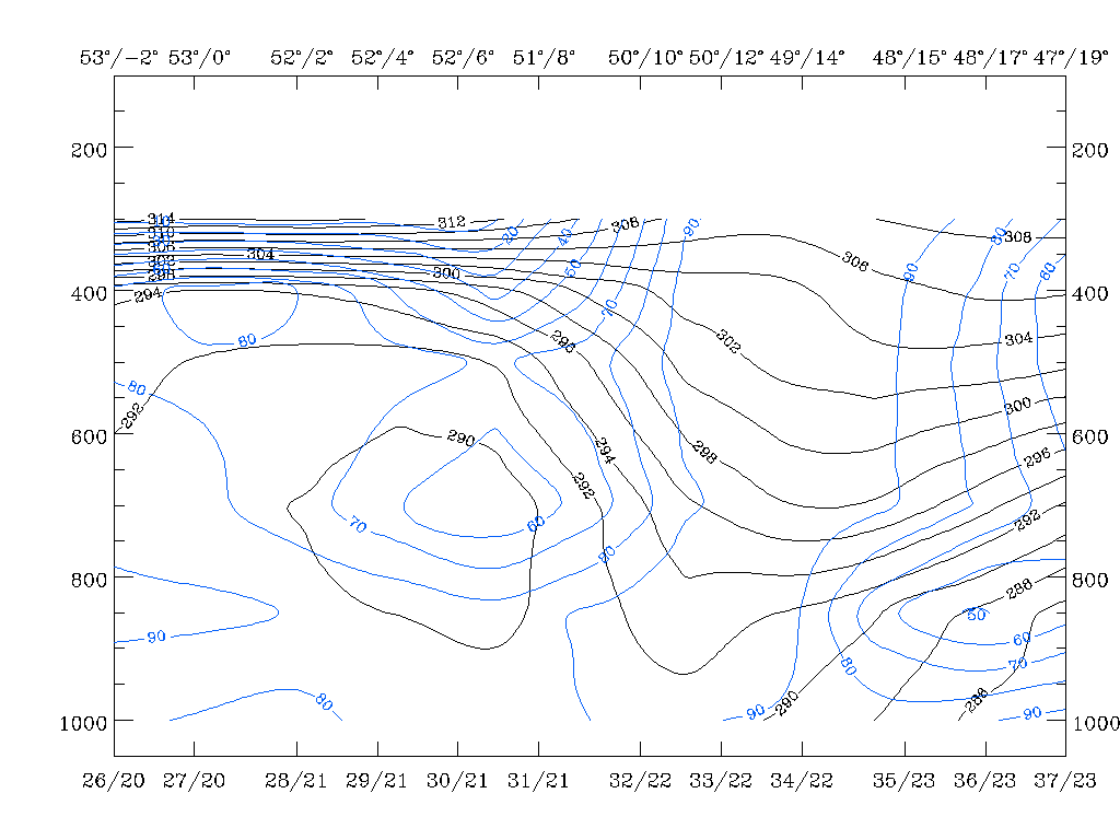
The black lines in the two cross sections represent equivalent potential temperatures and show a broad crowding zone and a zone of high gradients of isentropes. Such a zone indicates a frontal surface in showing the quick change of temperature (the temperature discontinuity) taking place at fronts. In this case the zone of highest gradients rises from the surface at about 50N/08E up to a layer of 500 - 400 hPa at approximately 54N/18E.
The relative humidity shows high values of 90% (up to about 700 hPa) and 70% (up to about 450 hPa) on top of this frontal surface. This characterizes the humid air gliding upwards while dry air is sinking below the frontal surface from heights around 400 hPa, where it is only 10% down to about 700 hPa where it is about 50%. Temperature advection consists of a broad zone of pronounced WA with maximal values within the frontal zone.
Both parameter fields show a transition zone between 600 and 400 hPa close to the southern end of the vertical cross section (48N/01E) where humidity decreases to 30% and WA to 0. Above this layer, between 400 and 300 hPa, a second area of WA with very humid air involved is indicated. This is an upper level Warm Front zone separated from the main warm front. Comparing with the satellite image, the accompanying cloudiness can be found within the warm sector where a second WA maximum has already been discussed. Satellite signals in the vertical cross section (orange lines) show a broad area of cold pixels reaching from the area just discussed north-eastward over the surface front. Only some distance away from the surface front (north-eastward direction) cloud top temperatures decrease. The sharp decrease at about 52N/11E is connected with the Dark Stripe in the WV image already discussed.
For investigations of relative streams the same isentropic surfaces are chosen as for the Cold Front: 298K and 304K. The 298K surface is close to the top of the frontal zone, the 304K surface already above.
|
18 February 1996/06.00 UTC - Meteosat IR image; magenta: relative streams 298K - system velocity 305° 18m/s, yellow: isobars, red:
front indicator, ECMWF grid superimposed, position of vertical cross section indicated
|
18 February 1996/06.00 UTC - Meteosat IR image; magenta: relative streams 305K - system velocity 305° 18m/s, yellow: isobars, red:
front indicator, ECMWF grid superimposed, position of vertical cross section indicated
|
|
|
As mentioned also in the Cold Front discussion (compare Cold Front ) three main relative streams can be identified, but only the Warm Conveyor Belt originating in the Mediterranean and streaming across Spain and France north-eastward is involved in the process of the Warm Front. On both surfaces a rising branch of the Warm Conveyor Belt from the south-west crosses the Warm Front line in north-easterly directions: on the lower 298K surface the air mass rises from about 700 hPa in the warm sector to 750 hPa at the surface front and further up to 580 hPa; on the higher surface rising takes place from about 600 hPa within the warm sector and up to 550 hPa at the surface front. Behind the surface front the Warm Conveyor Belt turns southwards, accompanied by with a transition from rising to sinking and a dissolution of cloudiness. This can clearly be observed in the Warm Front cloud shield of this case study.
The Warm Front situation in this case study fulfils the conceptual model considerations very well.
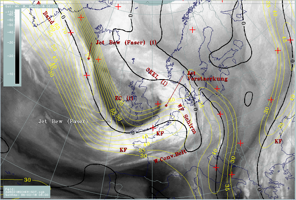
18 - 19 February 1996 - Cloud Fibre At Jet Axis
|
18 February 1996/06.00 UTC - Meteosat IR image; SatRep overlay: names of conceptual models; SatRep menu: key parameters for Jet
Cloudiness
|
18 February 1996/06.00 UTC - Meteosat WV image; yellow: isotachs 300 hPa, black: shear vorticity 300 hPa
|
|
|
There are two fibrous structures diagnosed in the IR image as the conceptual model "Jet Cloudiness (Fibre)" (compare Conceptual Models: Jet Cloudiness (Fibre) ): one over the Atlantic west of Iceland and a second one over the Atlantic south-west of Ireland crossing the Cold Front cloud band at a very pronounced angle. Comparing with the WV image these fibres are respectively at the eastern and northern boundary of a broad stripe of humid air with an adjacent narrow Black Stripe. This is a typical situation for a jet stream with the sharp boundary in the WV image and the fibres in the IR image close to the jet axis.
Consequently the key parameters from the conceptual model are contained in the following combination:
| Isot300 + Scher300=0 | This parameter combination shows the isotachs at 300 hPa greater than 30 units (m sec-1) and the zero line of shear vorticity at 300 hPa which marks the jet axis; one can get information about the existence and strength of jet streaks and the course of the jet axis |
|---|
However, although the 300 hPa level should be very close to the jet level, differences may occur. Therefore the bright boundary in the WV image need not automatically coincide with the zero line of shear vorticity at 300 hPa; on the contrary there can be significant differences as can be noticed by comparing the zero lines of shear vorticity at 500 and 300 hPa. Such a situation exists also in this case study; the humid air reaches to the anticyclonic side of the zero line (black line) of shear vorticity.
Cloud fibres which form within a rising conveyor belt should appear, according to the conceptual model, immediately at the jet axis but reaching into the anticyclonic side; consequently a comparison between the location of the fibre and the zero lines of shear vorticity at different levels can give some information about the height level of the real jet core. In this example it should be higher than 300 hPa over the Atlantic, but very close to 300 hPa at the point where it crosses the Cold Front cloud band.
18 - 19 February 1996 - Intensification Of Cold Front Through Jet Streak Crossing
|
18 February 1996/06.00 UTC - Meteosat IR image; SatRep overlay: names of conceptual models; SatRep menu: key parameters for Jet
Intensification
|
|
|
This part of the cloud band lies over the North Sea and differs in its appearance from the rest of the Cold Front band; while the latter is relatively homogeneous, the former has much more structure in the form of cells. Unfortunately, weather activity cannot be proved because of its position over the sea.
Such areas very often are the result of the interaction of frontal circulation and cross circulation in the exit region of a jet streak which approaches and finally crosses the front (compare Conceptual Models: Front Intensification by Jet Crossing - Meteorological physical background ). Therefore the following key parameters and their combinations are regarded as relevant:
| Front Indicator | This is a line indicating the maximum of the thermal front parameter (TFP) 500/850 hPa (*10-1Km-1) |
|---|---|
| Isot + PVA300>=3 | This is a combination of isotachs greater than 30 units (m sec-1 and positive vorticity advection (PVA) at 300 hPa exceeding 3 units (*10-5) sec-2 |
| Isot + PVA300>=2 | This is a combination of isotachs greater than 30 units (m sec-1 and positive vorticity advection (PVA) at 500 hPa exceeding 2 units (*10-9) sec-2); both parameter combinations locate the exit region and the PVA maximum in relation to the frontal cloud band |
| Isot300 + Scher300=0 | This parameter combination shows the isotachs greater than 30 units (m sec-1) and the zero line of shear vorticity which marks the jet axis at 300 hPa; one can get information about the existence and strength of jet streaks and the course of the jet axis |
| Relative Stroeme (relative streams) | This parameter shows relative streams on isentropic surfaces; relative streams are indicative of the different air masses involved in the process and of areas of sinking or rising motion; they can be used to explain cloud configurations requiring special explanation |
|
18 February 1996/06.00 UTC - Meteosat WV image; red: front indicator, yellow: isotach 300 hPa, black: positive vorticity advection
(PVA) 300 hPa, SatRep overlay: names of conceptual models
|
18 February 1996/06.00 UTC - Meteosat WV image; red: front indicator, yellow: isotach 500 hPa, black: positive vorticity advection
(PVA) 500 hPa, SatRep overlay: names of conceptual models
|
|
|
The two images show at 500 as well as at 300 hPa two pronounced jet streaks; the more extended one reaches from the North Atlantic southward to the Cold Front cloud band that it crosses close to Cornwall. A smaller one is more pronounced at 300 hPa and is relatively parallel to the cloud band in the English Channel, crossing the band near the occlusion point over the Netherlands (compare Conceptual Models: Cold Front ).
With the main western jet streak, a separate strong PVA maximum is connected only at 500 hPa and can be found west of Cornwall superimposed on the frontal cloud band. But this maximum appears exactly within the jet axis and not in the left exit region. This configuration, as well as the lower height level, is typical for situations where curvature vorticity as a consequence of a pronounced trough is strong.
Another strong PVA maximum can be found over south-east England in both levels. The PVA maximum is also situated within the jet axis and indicates therefore pronounced cyclonic curvature. But there is a secondary maximum of PVA at both levels exactly over the North Sea and the cellular structured cloud part. Concluding from the relation of all parameters, this PVA maximum should be in the left exit region and therefore rather the consequence of shear vorticity. Unfortunately, its effect on weather events cannot be evaluated because of the lack of observational data over the sea.
18 - 19 February 1996 - Enhanced Cumulus
Within the cellular cold air cloudiness behind the cold front, there is an area over Northern Ireland reaching north-westwards where the tops of cells are colder. This is typical Enhanced Cumuli cloudiness (EC) (compare Conceptual Models: Enhanced Cumulus ). The characteristic key parameters and key parameter combinations are:
| Rel.Top. + TA=<0 | This combination gives an overview at the larger scale situation; typically ECs can be found within the thickness troughs on the rear of the Cold Front mostly within cold advection CA 500/1000 hPa |
|---|---|
| PVA500>=2 | Positive vorticity advection (PVA) at 500 hPa exceeding a threshold of 2 units (*10-9 sec-2); well developed cases show up with pronounced PVA maxima which can also be followed prognostically |
| Isot + PVA300>=3 | This is a combination of isotachs greater than 30 units (m sec-1) and positive vorticity advection (PVA) at 300 hPa exceeding 3 units (*10-9 sec-2); this combination indicates a special situation where ECs can develop, namely in the left exit region of jet streaks |
|
18 February 1996/06.00 UTC - Meteosat IR image; white: equivalent thickness 500/850 hPa, red thick: front indicator, red: temperature
advection - CA 1000 hPa, yellow: positive vorticity advection (PVA) 500 hPa, SatRep overlay: names of conceptual models
|
|
|
All key parameters show in this case a typical behaviour for the development of EC cloudiness. It is situated in the centre of a small-scale thickness trough (white isolines), in the maximum of cold advection (CA) (red dashed lines) and it coincides with a separate PVA maximum (yellow) at 500 hPa. A comparison with the jet streak situation (compare Intensification of cold front through jet streak crossing ) confirms that in addition to curvature, the EC is also under the influence of a left exit region of the Atlantic jet streak.
18 - 19 February 1996 - Forecast For The Cold Front For 18 February 12.00 UTC And 18.00 UTC
|
18 February 1996/06.00 UTC - Meteosat IR image; SatRep overlay: names of conceptual models; SatRep menu: key parameters for Cold Front
forecast
|
|
|
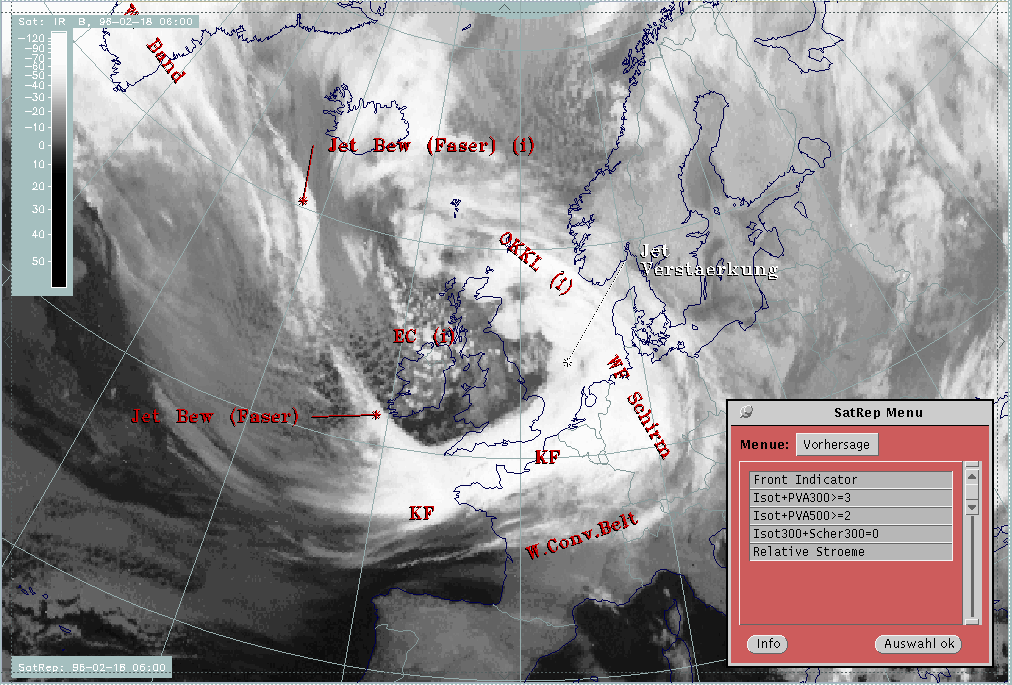
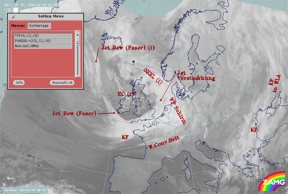
Concerning the forecast of the conceptual model "Cold Front" in the SatRep Menu, a button "Vorhersage" (= forecast) has to be clicked on and the relevant menu appears. As can be seen in the right upper corner, two kinds of forecasts and forecast intervals are presented:
The very short range forecast VSRF (06.00 - 18.00 UTC, 12 hours)
For the very short range forecast, six-hourly forecasts from ECMWF are used, and those parameters which are key parameters of a conceptual model are prepared as overlays on the satellite image in three different colours, representing the three points of time 06.00, 12.00 and 18.00 UTC:
- yellow: 06.00 UTC
- green: 12.00 UTC
- blue: 18.00 UTC
Nowcasting (0-2 hours)
For this forecast interval atmospheric motion vectors (AMVs) are used which extrapolate the cloud systems for the next two hours. These nowcasts are renewed half-hourly or hourly and are not discussed here.
|
18 February 1996/06.00 UTC - Meteosat IR image; yellow: thermal front parameter (TFP) 500/850 hPa 06.00 UTC, green: thermal front
parameter (TFP) 500/850 hPa 12.00 UTC, blue: thermal front parameter (TFP) 500/850 hPa 18.00 UTC
|
|

|
For the frontal characteristics see cold front diagnosis for 06 UTC (compare Cold Front ).
The thermal front parameter indicating location of the Cold Front is propagating very fast from the west European coast to central France and west Germany at 12.00 UTC, and south France, Switzerland and Austria at 18.00 UTC.
Estimates about intensity changes of the cloudiness using the isoline distribution of the TFP can only be made very roughly. For this, the parameter of PVA at 500 hPa is much more appropriate.
|
18 February 1996/06.00 UTC - Meteosat IR image; yellow: positive vorticity advection (PVA) 500/850 hPa 06.00 UTC, green: positive
vorticity advection (PVA) 500/850 hPa 12.00 UTC, blue: positive vorticity advection (PVA) 500/850 hPa 18.00 UTC
|
|

|
As can be seen in this case, the main strong PVA maximum over the North Sea close to the Belgian coast is elongated and split into two maxima. The more northern one propagates into Germany while the second one moves quickly south-eastwards into France and Switzerland. Both maxima remain strong until 12.00 UTC and weaken from then on until 18.00 UTC.
Another forecast help is to inspect the vertical cross sections computed from ECMWF forecast fields. Besides providing information about propagation, this method has the advantage of gaining insight into the changes in the vertical structure of the frontal surface.
|
18 February 1996/06.00 UTC - Meteosat IR enhanced image; position of vertical cross section indicated
|
18 February 1996/06.00 UTC - Vertical cross section; black: isentropes (ThetaE), blue: relative humidity, orange thin: IR pixel values,
orange thick: WV pixel values
|

|
|
|
|
|
18 February 1996/12.00 UTC - Vertical cross section; black: isentropes (ThetaE), blue: relative humidity, orange thin: IR pixel values,
orange thick: WV pixel values
|
18 February 1996/18.00 UTC - Vertical cross section; black: isentropes (ThetaE), blue: relative humidity, orange thin: IR pixel values,
orange thick: WV pixel values
|
The line of the vertical cross section indicated in the satellite image cuts through the Cold Front, the warm sector and the southern parts of the Warm Front. The vertical cross sections of ThetaE (black lines) show the two frontal zones as inclined zones of high gradients. They clearly move eastward from 06.00 to 18.00 UTC merging somewhat. At 12.00 UTC ECMWF gridpoint 31/22 separates the two fronts at the ground level; at 18.00 UTC it is the gridpoint 33/22. The blue lines represent relative humidity and show an intensive wet zone on top of the two frontal zones and, consequently, also between them. Dry air can be seen only on top of the Cold Front zone but does not protrude downward to any great effect in this period.
All other parameters, especially PVA and vertical motion (Omega), indicate a continuously high intensity of the eastward-moving cold front for 12.00 and 18.00 UTC. The PVA field contains at 300 hPa a pronounced maximum which is superimposed on the frontal zone as well as on the cloudiness connected to it and moves eastward. Vertical motion shows a very intensive zone of upward motion (negative values of Omega) on top of the Cold Front surface; during an increasing inclination of the crowding zone of isentropes representing the Cold Front until 18.00 UTC, the maximum of vertical motion inclines in the same way.
|
18 February 1996/06.00 UTC - Vertical cross section; black: isentropes (ThetaE), green thick: vorticity advection - PVA, green thin:
vorticity advection - NVA, orange thin: IR pixel values, orange thick: WV pixel values
|
18 February 1996/12.00 UTC - Vertical cross section; black: isentropes (ThetaE), green thick: vorticity advection - PVA, green thin:
vorticity advection - NVA, orange thin: IR pixel values, orange thick: WV pixel values
|
|
|
|
|
|
18 February 1996/18.00 UTC - Vertical cross section; black: isentropes (ThetaE), green thick: vorticity advection - PVA, green thin:
vorticity advection - NVA, orange thin: IR pixel values, orange thick: WV pixel values
|
|
|
18 February 1996/06.00 UTC - Vertical cross section; black: isentropes (ThetaE), cyan thick: vertical motion (omega) - upward motion,
cyan thin: vertical motion (omega) - downward motion, orange thin: IR pixel values, orange thick: WV pixel values
|
18 February 1996/12.00 UTC - Vertical cross section; black: isentropes (ThetaE), cyan thick: vertical motion (omega) - upward motion,
cyan thin: vertical motion (omega) - downward motion, orange thin: IR pixel values, orange thick: WV pixel values
|

|
|

|
|
|
18 February 1996/18.00 UTC - Vertical cross section; black: isentropes (ThetaE), cyan thick: vertical motion (omega) - upward motion,
cyan thin: vertical motion (omega) - downward motion, orange thin: IR pixel values, orange thick: WV pixel values
|
A comparison of the images for 06, 12 and 18 UTC supports the conclusion that there is pronounced frontal activity of the Cold Front throughout this period of time. One additional and interesting fact can be derived from an inspection of the images: the rearward boundary of the Cold Front band which has lower cloud tops (yellow-red-brown) in comparison to the leading parts (green-blue) becomes larger until 18.00 UTC. This may be an indication of a transition from an Ana to a Kata Front type. ECMWF forecast parameters used with the vertical cross section, such as humidity or isotachs do not show this change clearly.
|
18 February 1996/06.00 UTC - Meteosat IR enhanced image; position of vertical cross section indicated
|
18 February 1996/12.00 UTC - Meteosat IR enhanced image; position of vertical cross section indicated
|
|

|
|
|
|
18 February 1996/18.00 UTC - Meteosat IR enhanced image; position of vertical cross section indicated
|
18 - 19 February 1996 - Forecast For The Warm Front For 18 February 12.00 UTC And 18.00 UTC
|
18 February 1996/06.00 UTC - Meteosat IR image; SatRep overlay: names of conceptual models; SatRep menu: key parameters for Warm Front
forecast
|
|
|
Concerning the forecast of the conceptual model "Warm Front" in the SatRep Menu a button "Vorhersage" (= forecast) has to be clicked on and the relevant menu appears. As can be seen in the right upper corner, two kinds of forecasts and forecast intervals are presented:
The very short range forecast VSRF (06.00 - 18.00 UTC, 12 hours)
For the very short range forecast, six-hourly forecasts from ECMWF are used, and those parameters which are key parameters of a conceptual model are prepared as overlays on the satellite image in three different colours, representing the three points of time 06.00, 12.00 and 18.00 UTC:
- yellow: 06.00 UTC
- green: 12.00 UTC
- blue: 18.00 UTC
Nowcasting (0-2 hours)
For this forecast interval, atmospheric motion vectors (AMVs) are used which extrapolate the cloud systems for the next two hours. These nowcasts are renewed half-hourly or hourly and are not discussed here.
|
18 February 1996/06.00 UTC - Meteosat IR image; yellow: thermal front parameter (TFP) 500/850 hPa 06.00 UTC, green: thermal front
parameter (TFP) 500/850 hPa 12.00 UTC, blue: thermal front parameter (TFP) 500/850 hPa 18.00 UTC
|
|

|
For the frontal characteristics see warm front diagnosis for 06.00 UTC (compare Warm Front ).
As has been mentioned in the diagnosis, the TFP field shows a trough-like feature for the maximum of the TFP where the warm front should be indicated. This feature can be followed until 18.00 UTC. At 06.00 UTC (yellow) it can be found over the Netherlands, Belgium and west Germany, at 12.00 UTC (green) over west Germany and Switzerland and at 18.00 UTC over south Germany, Austria and Croatia.
|
18 February 1996/06.00 UTC - Meteosat IR image; yellow: temperature advection - WA 1000 hPa 06.00 UTC, green: temperature advection -
WA 1000 hPa 12.00 UTC, blue: temperature advection - WA 1000 hPa 18.00 UTC
|
|
|
The second parameter relevant for warm fronts is WA. Maximal WA propagates to the north-east.
TFP as well as WA do not give indications for intensity changes, but the vertical cross sections can help with this question.
|
18 February 1996/06.00 UTC - Vertical cross section; black: isentropes (ThetaE), cyan thick: vertical motion (omega) - upward motion,
cyan thin: vertical motion (omega) - downward motion, orange thin: IR pixel values, orange thick: WV pixel values
|
18 February 1996/12.00 UTC - Vertical cross section; black: isentropes (ThetaE), cyan thick: vertical motion (omega) - upward motion,
cyan thin: vertical motion (omega) - downward motion, orange thin: IR pixel values, orange thick: WV pixel values
|
|

|
|
|
|
18 February 1996/18.00 UTC - Vertical cross section; black: isentropes (ThetaE), cyan thick: vertical motion (omega) - upward motion,
cyan thin: vertical motion (omega) - downward motion, orange thin: IR pixel values, orange thick: WV pixel values
|
Vertical motion on top of the frontal surface clearly shows a decrease in intensity. While at 06.00 UTC upward motion can be noticed on top of the Warm Front surface between the gridpoints 28/21 and 32/22, at 12 UTC only the lowest part of the Warm Front surface is under upward motionwhile the higher parts already undergo sinking. At 18.00 UTC sinking prevails on almost the whole Warm Front surface.
The satellite images of these three points of time confirm this decrease by showing dissolution of Warm Front cloudiness.
|
18 February 1996/06.00 UTC - Meteosat IR image;yellow: thermal front parameter (TFP) 500/850 hPa 06.00 UTC, green: thermal front
parameter (TFP) 500/850 hPa 12.00 UTC, blue: thermal front parameter (TFP) 500/850 hPa 18.00 UTC
|
18 February 1996/06.00 UTC - Meteosat IR enhanced image; position of vertical cross section indicated
|
|

|
|

|
|
18 February 1996/12.00 UTC - Meteosat IR enhanced image; position of vertical cross section indicated
|
18 February 1996/18.00 UTC - Meteosat IR enhanced image; position of vertical cross section indicated
|
18 - 19 February 1996 - Forecast For The Enhanced Cumulus For 18 February 12.00 UTC And 18.00 UTC
|
18 February 1996/06.00 UTC - Meteosat IR image; SatRep overlay: names of conceptual models; yellow: positive vorticity advection (PVA)
500 hPa 06.00 UTC, green: positive vorticity advection (PVA) 500 hPa 12.00 UTC, blue: positive vorticity advection (PVA) 500 hPa 18.00
UTC
|
|
|
The discussion here is not a complete forecast procedure for Enhanced Cumuli (ECs); for this compare case study 12 March 1996 (see Case Study: 12 March 1996, Enhanced Cumulus ). Here only the key parameter of PVA 500 hPa is inspected for the 12 hours forecast. The EC over Ireland is accompanied by a distinct PVA maximum at 06.00 UTC (yellow) which cannot be followed further. There is only a very small PVA area nearly at the same place for 12.00 UTC (green), and no distinct centre for 18.00 UTC at all.
Comparing with the images, this is not verified completely because there is an area of enhanced cells which propagates from Ireland at 06.00 UTC to central England at 12.00 and the Netherlands at 18.00 UTC.
|
18 February 1996/06.00 UTC - Meteosat IR enhanced image; position of vertical cross section indicated
|
18 February 1996/12.00 UTC - Meteosat IR enhanced image; position of vertical cross section indicated
|

|

|

|
|
|
18 February 1996/18.00 UTC - Meteosat IR enhanced image; position of vertical cross section indicated
|
18 - 19 February 1996 - Diagnosis For 18 February 1996/06.00 UTC
|
18 February 1996/06.00 UTC - Meteosat IR image; red thick: front indicator, SatRep overlay: names of conceptual models; SatRep menu:
key parameters for Occlusion
|
|
|
For the diagnosis of the physical state of the Occlusion, a couple of key parameters and useful key parameter combinations are available which were chosen with respect to the conceptual model (for more information compare Conceptual Models: Occlusion: Warm Conveyor Belt Type ).
| Front Indicator | This is a line indicating the maximum of the thermal front parameter (TFP) 500/850 hPa (*10-1Km-1) |
|---|---|
| rel.Top + TA>=0 | This is a combination of the equivalent thickness 500/850 hPa (rel.Top) and warm advection (TA>=0) 500/1000 hPa; this combination of key parameters is especially indicative of the thermal qualities of an Occlusion |
| PVA500>=2 | This parameter shows maxima of positive vorticity advection (PVA) at 500 hPa exceeding 2 units (*10-9sec-2); this key parameter indicates areas with increased possibility for more severe weather events because of increased vertical motion (compare Front Intensification by Jet Crossing ) |
| Scher300=0 | The zero line of shear vorticity (Scher300=0) is a key parameter indicative of the relation between front and jet stream; in this connection the basic rule that the jet stream crosses the cloud band with its axis close to the Occlusion point is included. |
|
18 February 1996/06.00 UTC - Meteosat IR image; red thick: front indicator, green: equivalent thickness 500/850 hPa, red: temperature
advection - WA 1000 hPa, SatRep overlay: names of conceptual models
|
18 February 1996/06.00 UTC - Meteosat IR image; red thick: front indicator, yellow: positive vorticity advection (PVA) 500 hPa, SatRep
overlay: names of conceptual models
|
|
|
The parameter distribution indicates a typical situation for an Occlusion band, namely a pronounced ridge in the thickness field (white) extending from the Netherlands coast into the North Sea, and an area of WA (red) within this ridge and superimposed on the cloud band. As mentioned in connection with the Warm Front (compare Conceptual Model: Warm Front Band , Conceptual Model: Warm Front Shield and Conceptual Model: Detached Warm Front ) and Occlusion (compare Conceptual Model: Occlusion: Warm Conveyor Belt Type ) during this stage of development the maximum of WA is not in the area of the Warm Front Band but shifted to the Occlusion band and close to the Occlusion point.
There is another very typical configuration fulfilled in the key parameters: the zero line of shear vorticity at 300 hPa representing the jet axis (black line) crosses the cloud band exactly at the Occlusion point indicated by the front indicator (thick red line).
As can be seen in the second image, this point as well as the southern part of the Occlusion band are under the influence of PVA.
Looking at these typical diagnoses there should be no doubt about the physical state of an Occlusion in the region under discussion. However, there are some indications that contradict this classical model. The cloud spiral in the satellite image is not as distinct as is usually the case with Occlusion bands, and there are some dissolution effects in the northern part over the North Sea. But the main difference appears in the vertical cross section.
|
18 February 1996/06.00 UTC - Meteosat IR image; SatRep overlay: names of conceptual models, position of vertical cross section indicated
|
18 February 1996/06.00 UTC - Vertical cross section; black: isentropes (ThetaE), blue: relative humidity, orange thin: IR pixel values,
orange thick: WV pixel values
|

|
|
|
|
|
18 February 1996/06.00 UTC - Vertical cross section; black: isentropes (ThetaE), red thin: temperature advection - CA, red thick:
temperature advection - WA, orange thin: IR pixel values, orange thick: WV pixel values
|
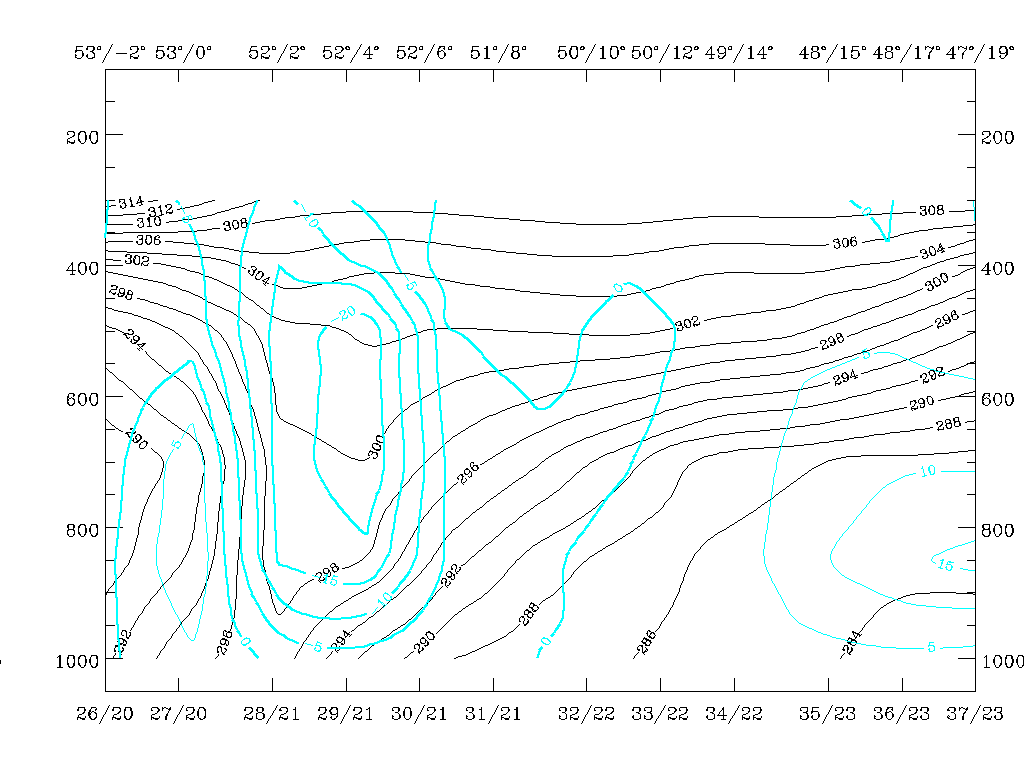
The vertical cross section extends from Sweden across the Occlusion band over the North Sea to central England. The typical appearance of an Occlusion band in the vertical cross section can be seen in the manual (compare Conceptual Model: Occlusion: Warm Conveyor Belt Type - Typical appearance in vertical cross section ). Equivalent potential temperature forms a pronounced trough with a Warm Front - like zone at the leading and a Cold Front - like zone at the rearward edge of the cloud band. In the centre of this trough high humidity and a maximum of WA indicate cloudiness as well as the Occlusion process.
In this case equivalent potential temperature shows a completely different structure. The main feature is a pronounced thick zone typical for a Cold Front, inclined from about 400 hPa over Sweden down to gridpoint 27/17, which is close to the rear end of the cloud band immediately east of the Scottish coast. A trough-like configuration in the isentropes only exists higher than approximately 600 hPa, and may indicate an Occlusion there.
Wet air is in front and on top of the frontal zone with very high values in high levels above 600 hPa; there is very dry air (less than 30%) within and below the frontal zone and an even drier maximum of less than 20% just approaching on top of the frontal zone from north-east. WV and IR pixel values are very similar with a jump from typically cloud-free to cloudy values near 61°N/08°E, and a rather broad band extends south-westwards over the trough feature in the isentropes. The vertical distribution of temperature advection shows the typical appearance of an Occlusion band with a maximum of WA centred around the trough in the isentropes, typical for an Occlusion but with maximal values of WA below it. The whole frontal zone north-eastward from the gridpoint 29/15 is under CA, an area which is already outside the main part of the cloud band.
Summarizing these different features, one can conclude on the basis of a couple of key parameters, that an Occlusion cloud band exists but is undergoing transformation to a new Cold Front. This process will be evaluated in more detail.
Two characteristic isentropic surfaces are selected: ThetaE = 290K, a surface which is within the frontal zone of the Cold Front close to its top and appears only in this cloud system, and ThetaE = 300K. This surface is relatively high in relation to this cloud system, but the connection to the main Warm and Cold Front cloud bands is more evident.
|
18 February 1996/06.00 UTC - Meteosat IR image; red thick: front indicator, magenta: relative streams 290K - system velocity 305°
18m/s, yellow: isobars, SatRep overlay: names of conceptual models, position of vertical cross section indicated
|
18 February 1996/06.00 UTC - Meteosat IR image; red thick: front indicator, magenta: relative streams 300K - system velocity 305°
18m/s, yellow: isobars, SatRep overlay: names of conceptual models, position of vertical cross section indicated
|
|
|
On the 290K surface in the area of the cloud band, the layer from the ground up to about 600 hPa is considered. Relative streams are oriented normally to the vertical cross section and flow through it at about 700 hPa with a rising component, while further north-westward the relative streamlines keep approximately the same height. Comparing with the other parameters in the vertical cross section, this is the point where maximal WA exists, but where also already the transition between wet and dry air masses takes place. From the point of view of conceptual models this relative air stream should be characteristic for the Cold Conveyor Belt (compare Conceptual Models: Occlusion: Warm Conveyor Belt Type - Meteorological physical background ) which does not contribute much to the cloudiness.
Another relative stream merges with the Cold Conveyor Belt from more north-eastern directions exactly in the region of the cross section. This stream is sinking from about 500 hPa down to 650 hPa where it meets the relative stream from the south which has been discussed above. Comparing again with the vertical cross section, this relative stream from east and north-east transports much drier air.
The higher 300K isentropic surface describes a layer between 400 and 350 hPa in the area of the vertical cross section. In this layer a relative stream from the humid side on the back of the Cold Front crosses (compare Cold Front and Conceptual Models: Cold Front - Meteorological physical background ) the vertical cross section, rising strongly over the North Sea but only moderately in the more northern part of the Occlusion. Describing the qualities of air masses at this height of the vertical cross section clearly shows that this is the region of highest humidity, connected with the brightest peak in the IR and WV imagery. So this relative stream is responsible for the formation of the high level cloudiness.
Similarly to the lower 290K surface, a sinking relative stream from north-eastern directions forms a limiting stream line for the north-eastern edge of the cloud band.
|
18 February 1996/06.00 UTC - Meteosat IR image; red thick: front indicator, magenta: relative streams 300K - system velocity 305°
18m/s, yellow: isobars, cyan: potential vorticity 300K, SatRep overlay: names of conceptual models, position of vertical cross section
indicated
|
|
|
In addition to the contents of the image just discussed, the blue lines indicate isentropic potential vorticity (IPV) on this surface. According to theory, IPV values lower than 1 unit are indicative of tropospheric air, values higher than 2 IPV units of dry stratospheric air, while between 1 and 2 IPV units a transition area is expected. In this situation it can be concluded that very dry stratospheric air is transported by relative streams from the Norwegian coast under sinking motion in a south-eastward direction towards the Occlusion cloud band.
This may be a typical situation for the start of a transformation from Occlusion to Cold Front cloud band. For a further development see Forecast for "Special Investigation": 18 February 12.00 to 19 February 06.00 UTC .
18 - 19 February 1996 - Forecast For "special Investigation": 18 February 12.00 UTC To 19.00 February 06.00 UTC
|
18 February 1996/18.00 UTC - Meteosat IR enhanced image; position of vertical cross section indicated
|
18 February 1996/06.00 UTC - Meteosat IR enhanced image; position of vertical cross section indicated
|

|

|
Two changes can be noticed: The cloud band of the Occlusion under discussion has moved southward as a whole without showing any notable changes in cloudiness, and the orientation of the vertical cross section is aligned more north-south crossing also the main Cold Front cloudiness.
|
18 February 1996/12.00 UTC - Vertical cross section; black: isentropes (ThetaE), red thin: temperature advection - CA, red thick:
temperature advection - WA, orange thin: IR pixel values, orange thick: WV pixel values
|
18 February 1996/12.00 UTC - Vertical cross section; black: isentropes (ThetaE), blue: relative humidity, orange thin: IR pixel values,
orange thick: WV pixel values
|
|
|
The isentropes clearly show two Cold Front zones with the distinct northern one inclined downward from about 400 hPa to the surface, reaching it close to 56N/04E which is on the southward edge of the cloud spiral. The appearance is very typical for a Cold Front with high humidity and WA on top of the frontal crowding zone of isentropes, and very dry air within the zone of high gradients. There is an area of less than 20% within the frontal zone around 500 hPa with a tongue of drier values reaching down to about 650 hPa. Compared to the relevant 06.00 UTC cross section (compare Diagnosis for 18 February 06.00 UTC ) considerable sinking of this dry air has taken place within these six hours. Compared to the TA for 12 UTC this dry air coincides with an area of CA.
The same two surfaces as for 06.00 UTC are selected for this point of time: 290K immediately on top of the frontal crowding zone, and 300K which is in the upper part of the troposphere.
|
18 February 1996/12.00 UTC - Meteosat IR image; magenta: relative streams 290K - system velocity 298° 14 m/s, yellow: isobars,
cyan: potential vorticity 290K, ECMWF grid superimposed, position of vertical cross section indicated
|
18 February 1996/12.00 UTC - Meteosat IR image; magenta: relative streams 300K - system velocity 298° 14 m/s, yellow: isobars,
cyan: potential vorticity 300K, ECMWF grid superimposed, position of vertical cross section indicated
|
|
|
The relative streams and their orientation to each other are very similar to 06.00 UTC: in 290K a relative stream from the south-east crosses the vertical cross section with weak rising east of it but changing to sinking west of it. A stream from north and north-east approaches this relative stream along the northern boundary of the cloud band. PV shows dry stratospheric air which is transported with sinking motion towards the cloud band. Looking at the vertical cross section on top of the 290K isentrope it can be noticed that the 500 hPa level coincides exactly with a minimum of less than 20% in the humidity field and is very close to the minimum in the CA field.
Also at the high 300K level the main configuration of relative streams is similar to 06.00 UTC, with a humid stream from the back of the Cold Front and a very dry stream from northern directions forming a limiting stream line to the cloud band. In addition to the 06.00 UTC situation, a saddle point now appears in this relative stream over south-west Norway. The branch crossing the vertical cross section is from regions with very high PV values (blue) in the north bending westwards along the northern edge of the cloud spiral.
|
18 February 1996/12.00 UTC - Meteosat IR image; red: temperature advection 1000 hPa, cyan: temperature advection 500 hPa
|
|
|
The CA mentioned several times in the interpretation of the vertical cross section can also be followed in relation to the satellite image. Red lines are temperature advection in the layer 500/1000 hPa, cyan lines in the layer 300/500 hPa. Both layers show the advection of cold air north of the cloud spiral.
In comparison to the situation at 06.00 UTC, the advection of dry and cold air on the northern side of the Occlusion band has intensified, but no notable changes have taken place between these two times.
18 February 18.00 UTC
|
18 February 1996/06.00 UTC - Meteosat IR enhanced image; position of vertical cross section indicated
|
18 February 1996/12.00 UTC - Meteosat IR enhanced image; position of vertical cross section indicated
|
|
|
In the satellite image an important change compared to 12.00 UTC has happened now. There is a clear cyclonic curvature of the cloud band under consideration towards the northern area which is the area of the advection of dry and cold air. This is now a typical appearance of a Cold Front.
|
18 February 1996/18.00 UTC - Vertical cross section; black: isentropes (ThetaE), red thin: temperature advection - CA, red thick:
temperature advection - WA, orange thin: IR pixel values, orange thick: WV pixel values
|
18 February 1996/18.00 UTC - Vertical cross section; black: isentropes (ThetaE), blue: relative humidity, orange thin: IR pixel values,
orange thick: WV pixel values
|
|
|
The frontal zone formed by the isentropes is much more flat now, being inclined from around 500 hPa down to the surface at about 55N/04E, which is very close to the southern edge of the cloud band. Dry and cold air has not only moved downwards but also in a southward direction along the cross section line, which means that the air masses on top of as well as somewhat further away from the frontal zone are now involved in the physical processes.
|
18 February 1996/18.00 UTC - Meteosat IR image; magenta: relative streams 290K - system velocity 291° 12 m/s, yellow: isobars,
cyan: potential vorticity 290K, position of vertical cross section indicated
|
18 February 1996/18.00 UTC - Meteosat IR image; magenta: relative streams 295K - system velocity 291° 12 m/s, yellow: isobars,
cyan: potential vorticity 295K, position of vertical cross section indicated
|
|
|
The relative streams in the two isentropic surfaces 290K and 295K (300K is already too high for this stage of development) are very similar. There is a main wet stream from south-east to south-west which is rising in the eastern part of the cloud band and a dry stream from the north with a limiting stream line between the two streams close to the northern boundary of the cloud band. This northern dry stream originates from areas higher than 400 hPa with PV values indicative of stratospheric air which has (as will be shown at the end of this chapter) protruded southward.
Compared with a classical Cold Front (compare Conceptual Models: Cold Front - Meteorological physical background ) there is a very similar situation now with two different humid and converging streams, but in the case of a classical Cold Front, both streams would originate from western not eastern directions, unlike the case here where an Occlusion band is transformed into a new Cold Front.
|
18 February 1996/18.00 UTC - Meteosat IR image; red: temperature advection 1000 hPa, cyan: temperature advection 500 hPa
|
|
|
Maxima of CA over Scotland for 500/1000 hPa and west of Norway for 300/500 hPa indicate the propagating cold air. Without knowing the history of this case such a distribution of relative streams could not be expected.
19 February 00.00 UTC
At 19 February 1996/00.00 UTC the process continues and the relevant parameter distribution can be followed easily from the discussions up to now.
|
19 February 1996/00.00 UTC - Meteosat IR enhanced image; position of vertical cross section indicated
|
|
|
|
|
19 February 1996/00.00 UTC - Vertical cross section; black: isentropes (ThetaE), red thin: temperature advection - CA, red thick:
temperature advection - WA, orange thin: IR pixel values, orange thick: WV pixel values
|
19 February 1996/00.00 UTC - Vertical cross section; black: isentropes (ThetaE), blue: relative humidity, orange thin: IR pixel values,
orange thick: WV pixel values
|
|
|
|
|
|
19 February 1996/00.00 UTC - Meteosat IR image; magenta: relative streams 290K - system velocity 261° 10 m/s, yellow: isobars,
cyan: potential vorticity 290K, position of vertical cross section indicated
|
19 February 1996/00.00 UTC - Meteosat IR image; magenta: relative streams 295K - system velocity 261° 10 m/s, yellow: isobars,
cyan: potential vorticity 295K, position of vertical cross section indicated
|
The fields of CA in the two layers still show increasing CA with maxima over central and north England.
|
19 February 1996/00.00 UTC - Meteosat IR image; red: temperature advection 1000 hPa, cyan: temperature advection 500 hPa
|
|
|
Evolution from 18 February 06.00 UTC to 19 February 06.00 UTC
In this process of the change of an Occlusion cloud band into a Cold Front the propagation of PV values typical for stratospheric air and CA was essential. The next two images summarize this movement from 18 February 12.00 UTC until 19 February 06.00 UTC. Different colours represent different points of time: yellow: 18/12.00 UTC, green: 18/18.00 UTC, blue: 19/00.00 UTC and magenta: 19/06.00 UTC. The isoline with a PV value of one unit which separates tropospheric from stratospheric air moves from south Norway south-westwards to Scotland and central England.
CA maxima show up as dashed lines in the same colours as just mentioned. Attention has to be drawn to the area of the British Isles. A CA maximum moves from north of Scotland (small yellow circle) to south England and the English Channel, widening and increasing.
|
19 February 1996/06.00 UTC - Meteosat IR image; yellow: potential vorticity 18/12.00 UTC, green: potential vorticity 18/18.00 UTC, blue:
potential vorticity 19/00.00 UTC, magenta: potential vorticity 19/06.00 UTC
|
19 February 1996/06.00 UTC - Meteosat IR image; yellow: temperature advection - CA 18/12.00 UTC, green: temperature advection - CA
18/18.00 UTC, blue: temperature advection - CA 19/00.00 UTC, magenta: temperature advection - CA 19/06.00 UTC
|
|
|
Diagnosis for 19 February 06.00 UTC
|
19 February 1996/06.00 UTC - Meteosat IR image; SatRep overlay: names of conceptual models
|
|
|
According to the SatRep manual up to now where cloud systems are diagnosed as conceptual models with typical key parameters from numerical model output, the cloud band between south Sweden and the coast of the Netherlands would have been analysed as a Cold Front predominantly because of its appearance in the satellite image. This is indicated by the rose colour and the brackets in connection with the name "KF" (Cold Front), in comparison to the red colour which is used if a conceptual model is fulfilled in all the different key parameter fields. This is not the case for this study because there are a lot of deviations from the classical Cold Front situation which are a consequence of the different evolution of this system. The next two images show that the new Cold Front is on the rear side of a dominant low pressure system, which is a sign for the transformation of an Occlusion into a Cold Front. An additional insight into the structure of the troposphere can be derived from the combination of thickness, thermal front parameter and temperature advection. There are two cold air troughs: one behind the main Cold Front over central Europe and a second, newly developed one behind the transformed Cold Front over the North Sea and the British Isles. The cyclonic curvature of the TFP and of the zero line of temperature advection along the west European coast are another indication for the process discussed in this special investigation.
|
19 February 1996/06.00 UTC - Meteosat IR image; red thick: front indicator, red: height contours 1000 hPa, green: height contours 500
hPa, SatRep overlay: names of conceptual models
|
19 February 1996/06.00 UTC - Meteosat IR image; red thick: front indicator, blue: thermal front parameter (TFP), green: equivalent
thickness 500/850 hPa, red: temperature advection - WA 1000 hPa, SatRep overlay: names of conceptual models
|
|
|