Vertical Cross Sections and Profiles
Vertical Cross Sections for a fog event call for specific parameter investigations and the best possible vertical and horizontal resolution. In synoptic scale deep tropospheric systems the vertical cross sections may extend throughout the troposphere (up too 200 hPa), but for a radiation fog event the major interest is within the lowest kilometre of the atmosphere. In addition, the usual set of dynamical parameters, such as Vorticity Advection, Potential Vorticity or Temperature Advection, gives no further insight into the fog itself. However, they should always be checked as their absence is indeed a signal of potentially favourable conditions for fog events.For these reasons, in the following Vertical Cross Sections we will focus more into the lowest half of the atmosphere: top level of VCS is at 500 hPa. Also we use the best possible resolution of ECMWF operational model currently available (90 vertical levels, 15 levels within the lowest 150 hPa of the atmospehere). The VCS is drawn across southern England. Also respective vertical profiles for individual parameters are shown for Heathrow.
VCS across SE part of Britain and Vertical Profiles at Heathrow 19 Dec 2005/00 UTC - 23 Aug 2005/12 UTC
|
Isentropes Temperature Cloud Cover Relative Humidity |
Summary
The Vertical Cross Sections show that typical conditions for wintertime radiation fog event were prevailing. Temperature inversion was developing and intensifying throughout the episode, reaching its peak on 22 December, when the inversion strength was approximately 15 degrees. According to the model profiles the inversion was quite surface-based and allowed little vertical mixing.
Vertical Cross Sections also give some indication of why the fog layer lifted on 23rd December: the likely reason for breaking of the strong inversion and stagnant fog situation was the fact that a cloud layer from south was advected over the SE England (and hence also over the Heathrow airport). This radically changed the radiation balance of the fog layer beneath by reducing the long-wave radiation from fog top into the space. This in turn increased the thickness of boundary layer, and mixing was reinforced. This can be seen also in the METAR observations; as the mixed layer starts to develop, wind catches up again, and lifts the fog into mist. The METAR messages for 23 December do confim that another cloud layer on top of the fog was existing, see listing of original METAR messages below.
METAR EGLL 230450Z 35003KT 0800 R27L/0800 R27R/0650 FG OVC001 01/01 Q1042
METAR COR EGLL 230450Z 35003KT 0800 R27L/0800 R27R/0650 FG OVC001 01/01 Q1042
METAR COR EGLL 230520Z 35004KT 0500 R27L/1100 R27R/0900 FG OVC001 01/01 Q1042
METAR COR EGLL 230550Z 34004KT 300V030 0800 R27L/P1500 R27R/P1500 FG BKN001
METAR EGLL 230620Z 34004KT 4000 BR SCT002 BKN017 01/01 Q1042
METAR COR EGLL 230620Z 34004KT 4000 BR SCT002 BKN017 01/01 Q1042 NOSIG
METAR COR EGLL 230650Z 34005KT 5000 FEW003 OVC017 01/01 Q1042 NOSIG
METAR EGLL 230720Z 36004KT 320V030 4400 BR FEW003 OVC017 02/01 Q1042
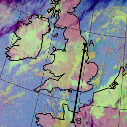
Satellite images support this assumption: the loop below (night-time RGB) shows a satellite loop between 22 December/18 UTC and 23 December/06 UTC. Clearly a low cloud layer can be seen moving from south-east over to SE England, onto a very shallow fog layer (hardly visible in satellite images). The use of satellite imagery together with VCS/profile data again gives a better understanding of what is going on within the boundary layer, and gives some tools to evaluate the likelihood for the dispersion of fog.