Chapter II: Synoptic overview
Table of Contents
- Chapter II: Synoptic overview
- Synoptic overview
Synoptic overview
Figure 2.1: Several surface and upper level weather charts from 17 to 19 September 2010.
From 17 to 19 September, weather in Slovenia and Croatia was under the influence of a strong and deep cyclone located over Scandinavia. The cyclone was more or less stationary for the first two days, but on the third day it moved slowly to the northeast. A cold front connected to the low was moving from central Europe towards the Alpine region. In the night from 17th to 18th September a cold front is moving over the Alps, Slovenia and Croatia. After the passage of the cold front a deep trough in the upper air was approaching from the west. On the 18th at around 00 UTC a cyclone started to develop near Genoa, causing an easterly flow in the lower levels with warm advection, while in the upper air slightly colder air was advected in a southwesterly flow.
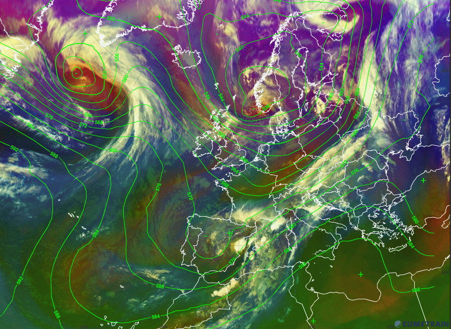
Figure 2.2: Meteosat 9 Airmass RGB overlayed with geopotential height 500 hPa, 18 Sep 00 UTC
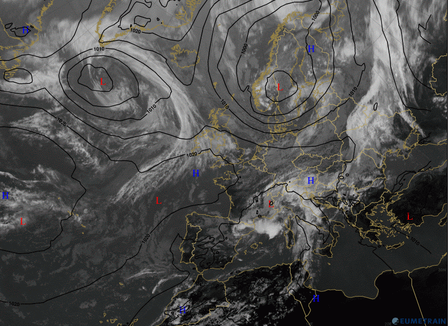
Figure 2.3: Meteosat 9 IR image overlayed with MSLP, 18 Sep 12 UTC
The cyclone from the Gulf of Genoa slowly moved further to the northeast, crossing Slovenia and northwestern Croatia in the night from 18th to 19th September and during the 19th. In the upper layers, the deep trough connected to the cyclone in northwestern Europe was also moving over Slovenia, Croatia and neighbouring countries. On the 19th around midday the upper trough passed the area.
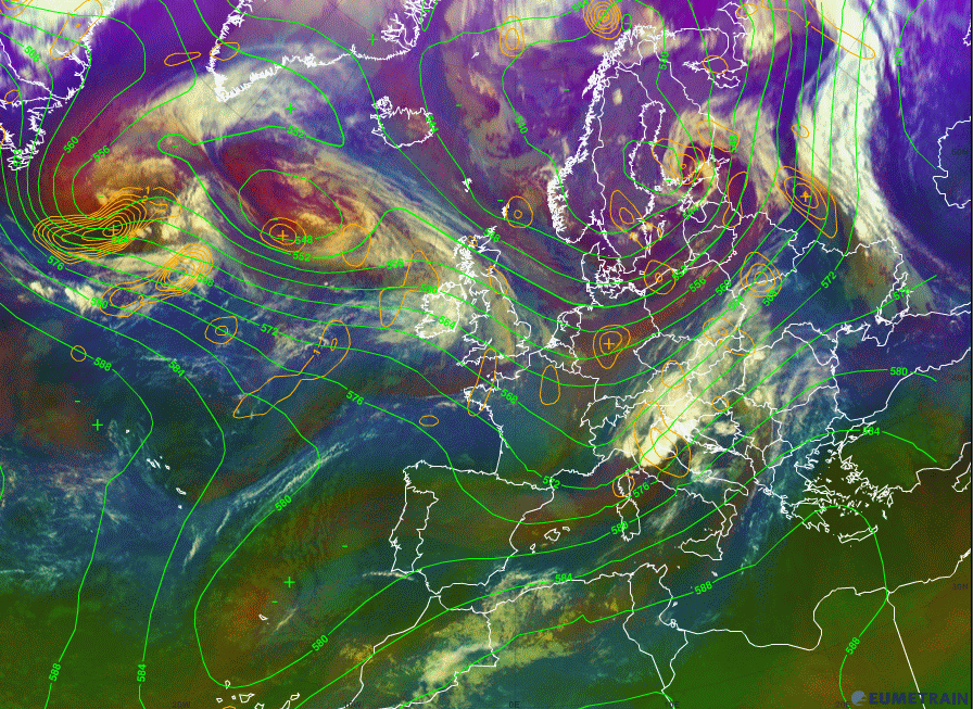
Figure 2.4: Meteosat 9 Airmass RGB overlayed with 500 hPa height and PVA at 500 hPa, 19 Sep 00 UTC
From this synoptic analysis one can conclude that the first wave of rainfall was connected to the crossing of the cold front in a strong southwesterly flow. The second wave was connected to the cyclone with the strong upper trough that was passingover Slovenia and Croatia on 19 September.
The deep trough with a cut off low over southern Portugal is spreading along the western coast of Europe. From the western Mediterranean towards central Europe there is a strong southwesterly stream in the upper levels. Cold air is penetrating from the north within the trough, as seen from the bluish colours in the airmass image.
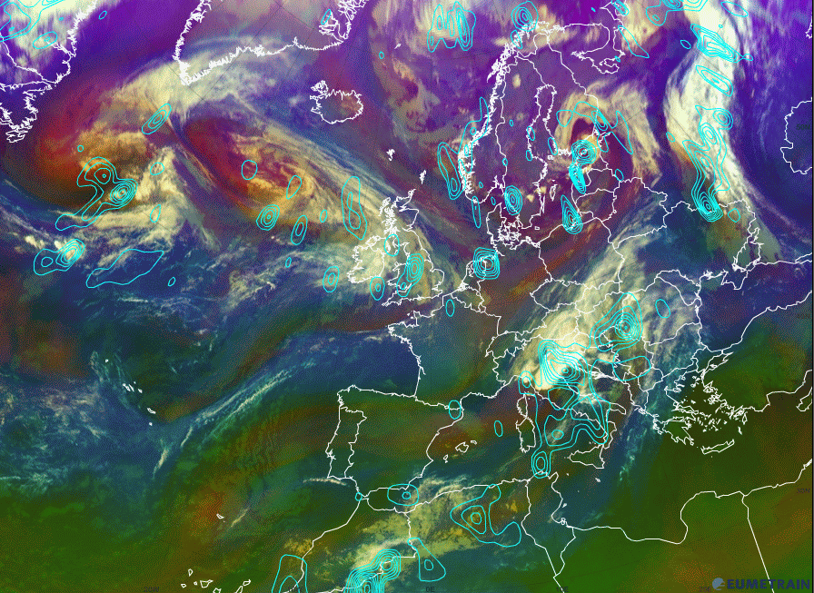
Figure 2.5: Meteosat 9 Airmass RGB overlayed with Omega at 700 hPa, 19 Sep 00 UTC
For some time this trough with the strong southwesterly flow is stationary, bringing moist and unstable air to the Alps and Slovenia and the western parts of Croatia. There is still no deep convection going on and most precipitation is orographically induced.
The first signs of strong convection can be seen on 18 September at 00 UTC. As the trough is moving to the east a low is forming in the Gulf of Genoa, and at that time very strong convection is present in the Alpine, Slovenian, North Adriatic and Gorski kotar regions (from 18 September 18 UTC to 19 September 12 UTC).
In the mean time (18 September 06 UTC) a frontal wave was forming over Austria, Slovakia, the Czech Republic and Poland. At the end of 19 September the trough has already passed Slovenia and Croatia and the weather is calming down. The rivers in Croatia are still growing because the major water wave is coming from the Alps and Slovenia.