Synoptic Situation and Satellite Overview
A frontal cloud band is moving from south Scandinavia over central Europe towards south-east Europe. It can be followed in the loop of Meteosat-8 IR images (10.8 micron channel). The frontal cloudiness was accompanied by precipitation, especially in the region enhanced by the influence of the jet streak. Convective clouds that appear behind the cloud band indicate the advection of cold air. The incoming jet is well depicted by the fibrous clouds that usually develop along the jet axis in the region of maximum wind. It is interesting to notice how at one point the intensification divides into two parts. This will later be explained in more detail.
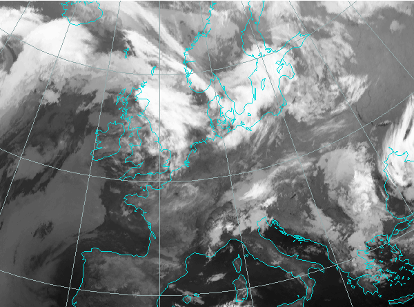
15 May 2004, 00 UTC
|
|
Following the chapters enable you to look at the stages of the development as seen in satellite images and basic meteorological fields:
Satellite overview
The movement of frontal cloud band from nortwest to southeast Europe and the episodes of the intensification can be seen in the relevant satellite channels in 3 hourly steps:
IR Imagery (Meteosat-8: 10.8 micron channel)
WV Imagery (Meteosat-8: 6.2 micron channel)
RGB Combination of channels 0.6 - 1.6 - 10.8 micron (Meteosat-8; channels 1-3-9)
Some basic explanation about RGB combinations of satellite images and their advantages can be found in MSG Interpretation Guide.
Basic synoptic parameters
Cloud configurations in satellite images combined with the basic field of surface pressure represented by geopotential height in 1000 hPa are shown here in 6-hourly sequence:
IR images and Geopotential height at 1000 hPa
Situation in the upper levels is shown by 500 hPa height in 6-hourly sequence.
IR images and Geopotential height at 500 hPa
Summary of the investigations in this chapter
In this case a frequent occurrence of Jet Intensification can be seen. Such development is usually accompanied by intensive precipitation and cold advection behind the front. The satellite images give opportunity to follow the processes on the larger scale.
In both IR and WV images, the cloud fibre (an indication of the jet axis) is crossing the cloud band of the cold front almost perpendicularly. The dark stripe in the WV images shows the intrusion of the dry upper level air (probably stratospheric) into the lower layers. On the other hand, in connection with the overrunning dry air the convective development take places and can be seen as a brighter area in the WV images.
The upper level ridge is all the time situated over the surface high, and the upper lever trough has the same location as the surface low, esspecialy during the 16th of May.
The conclusion, after looking through the satellite images and basic synoptic fields is that the intensification of the frontal cloud band occurred on the leading side of the upper-level ridge in a very strong northwesterly flow. Already from the 500 hPa field it is clear that strong northwesterly jet has played a major role in this development. The connection between the jet and the cloud enhancement is analysed in the Derived Meteorological Parameters chapter.