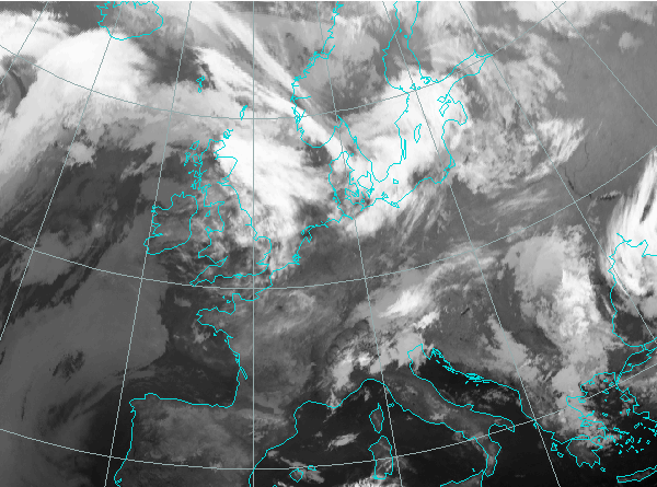
West and Central Europe is under the influence of an anticyclone. A shallow low can be seen in the Baltic sea and the cloud band is associated with the occlusion. The location of the jetstreak is indicated by the cloudfibres which are located from Island towards South Scandinavia. The most intensive clouds within the frontal cloud band in the IR image are found to the left of the fibrous clouds indicating jet axis. Here is the situation in sufrace pressure chart:

The situation is similar to the one 3 hours before. The frontal zone moved ia a southeasterly direction.
The cloud band is moving further south. From the brightness information it appears that a new intensification is taking place southwest from the first one. Jet coming from the north-west is much better seen in the WV images.
Over North Germany and Poland an area of frontal intensification can now clearly be identified as a huge cloud bulge. It is located to the left of the jet axis, according to the fibrous clouds that indicate the axis. Intensification of the frontal cloud band in that area is coincides with intensive precipitation.
The system is moving to the south-east and shows further intensification. Rain and showers are reported in the whole area of the intensification as seen in the synop reports:

Wind reports indicate that also the surface wind is much stronger in the area of front intensification. Mean wind speed up to 27 knots was reported in the area, as seen in the image below:

More convective development is now seen over Germany, Poland and Czech Republic. Notice how the intensification seems to split in two parts, which will even better be seen in the following images.
The cloudiness with much lower tops can be seen behind the main frontal zone. Again in the WV images, bright white area indicating convective development can be seen, whereas dark region behind it is an indication of dry air coming from upper levels. At this point the jet crosses the frontal cloud band almost perpendicularly, which is indicated by the shape of the clouds in the region of the intensification. The area to the left of the jet seems to be separating from the main intensified cloud bulge. This can be confirmed by looking at the isotachs field:

The precipitation reports again show that the strongest precipitation is found in the intensification area.

The system is moving further to the south-east. Now the separation of the two enhanced cloud structures is clearly seen.
Again the intensification of frontal clouds over Austria with showers reported. The area of intensification stands out from its surroundings because the cloud tops are much colder.

The west Europe is still under the influence of the anticyclone. The front is moving southwards on the front side of the ridge (anticyclone). Low clouds, darker on the satellite image over Russia indicate the stationary occlusion front.
Further propagation of the system can be followed. Notice a small "eye"; round, darker area to the north of the intensified clouds. This can be much better located in the WV images. This feature shows the intrusion of dry air from upper levels and is usually an indication for the beginning of cyclogenesis process.
As indicated by the WV eye, 3 hours later a Comma cloud feature starts to form over Hungary.
Behind the intensified frontal cloud band there is now a region of convective development indicating the advection of the cold air behind the front. A small cloud spiral can still be seen.
Cellular cloudiness behind the cold front indicates cold air. The front moves further to southeast and the intensification is still present.
Cold advection over Croatia, Slovenia and Austria can be seen by the cellular cloudiness.
The system is moving further to the south-east with precipitation over Bosnia and Hercegovina (snow at high mountains) and far more to the east.

At this point a Comma cloud structure has formed over the southern Adriatic.
The cold front is dissipating. The synoptic situation can be seen on the surface pressure chart.

The cold front is moving to south-east and slowly dissipating. Comma cloud, seen in the IR image over south Italy, is not indicated in the surface pressure, but there is a rather deep trough in 500 hPa height field.