Authors
Meteorological and Hydrological Service of Croatia - DHMZDunja Placko Vrsnak
Natasa Strelec Mahovic
Dunja Drvar
Introduction
This case study presents an interesting case of frontal intensification caused by jet crosing. The intensification of the frontal cloudiness takes place when a jet streak approaches the frontal cloud band. In the satellite images elongated cloud fibres often indicate the location of jet axis, whereas the intensification area is well recognizable through much brighter grey-shades within the frontal cloud band. The areas of intensification are usually chracterized by more intensive precipitation, often in shower form, sometimes accompanied by lightning.
In the image below cloud fibres can be seen north-west of Norway and the cloud bulge over Baltic Sea and south Sweden is already a well-defined frontal intensification on the left-hand side of the jet axis.
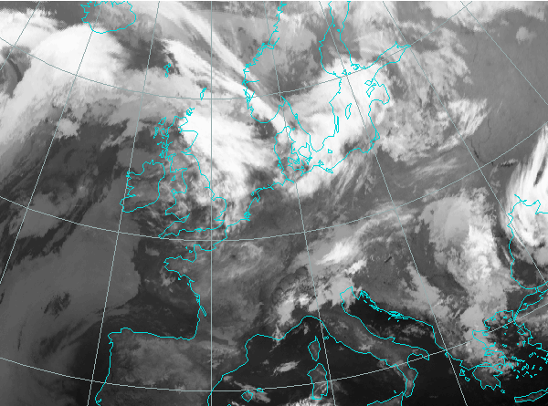
15 May 2004, 00 UTC- Meteosat-8; IR 10.8 μm channel
The process is usually well depicted in the relevant parameter fields which show the background of the development. The intensified cloud growth is found just to the left of where the jet stream (depicted by yellow isotachs) crosses the frontal cloud band. In that area there is positive vorticity advection (PVA) maximum (red) at the left exit region of the jet streak. The connection between the PVA maxima and the cloud development is described in Physical Background chapter.
The described parameter distribution can be seen in the image below.
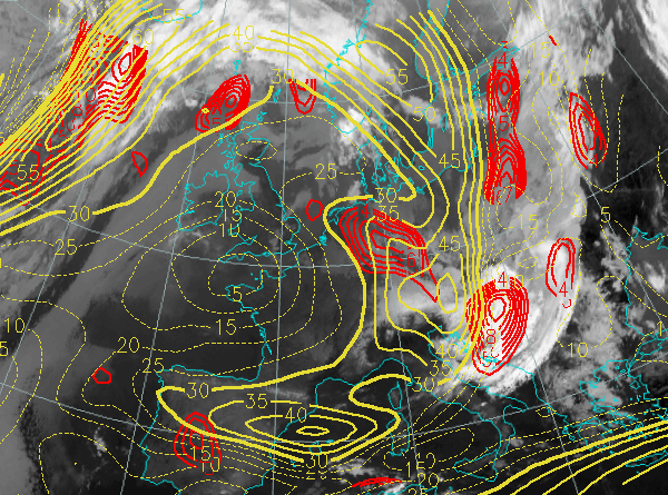
16 May 2004, 06 UTC- Meteosat-8; IR 10.8 μm channel; overlayed with isotachs and positive vorticity advection at 300 hPa.
In the following chapters the process of frontal intensification caused by jet crossing will be looked at through satellite images and relevant parameter fields and the explanation of physical processes behind the development will be given.