Vertical Motion and Divergence
In addition to the parameters on isentropic surfaces the conceptual model "Front Decay" shows up very well in some parameters on isobaric surfaces. These partly rather basic parameters are available in forecast fields, and therefore be used operationally. The case study is in very good agreement with the basic findings.
Vertical Motion and Divergence
|
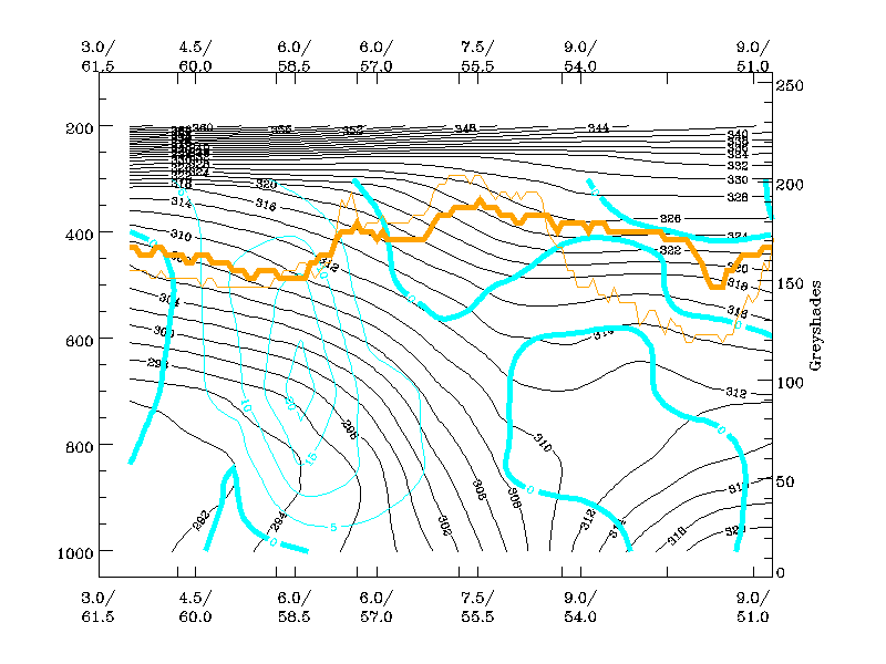
02 June 2000/18.00 UTC - Vertical cross section; black: isentropes (ThetaE), cyan thick: vertical motion (omega) - upward motion, cyan
thin: vertical motion (omega) - downward motion, orange thin: IR pixel values, orange thick: WV pixel values
|
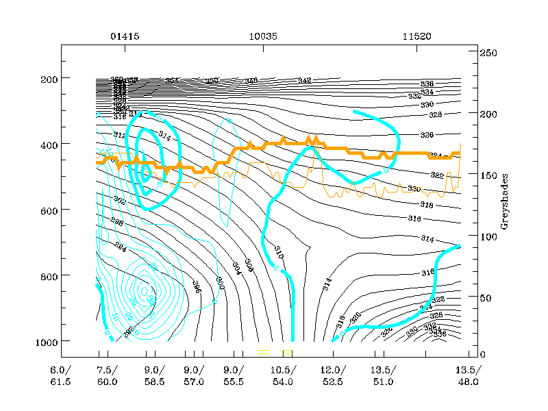
03 June 2000/00.00 UTC - Vertical cross section; black: isentropes (ThetaE), cyan thick: vertical motion (omega) - upward motion, cyan
thin: vertical motion (omega) - downward motion, orange thin: IR pixel values, orange thick: WV pixel values
|
|
|
|
|
|
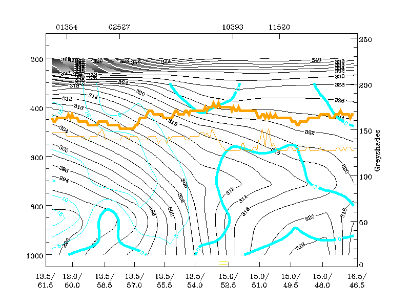
03 June 2000/06.00 UTC - Vertical cross section; black: isentropes (ThetaE), cyan thick: vertical motion (omega) - upward motion, cyan
thin: vertical motion (omega) - downward motion, orange thin: IR pixel values, orange thick: WV pixel values
|
|
At 02/18.00 UTC the field of vertical motion indicates positive values within the frontal gradient zone implying descent. This is in contrast
with a classical Cold Front (see
Conceptual Models: Cold Front
). At 00.00 UTC, the descent becomes very strong to the rear of the frontal gradient zone at low levels, and has a secondary maximum above the
front. The appearance of this field of vertical motion is in general agreement with observations of the behaviour of relative streams in the
previous chapter.
By 06.00 UTC, there is a broad zone of downward motion at all levels within the frontal zone, supporting the observed complete dissipation of
the cloud band, as seen within the satellite loops.
|
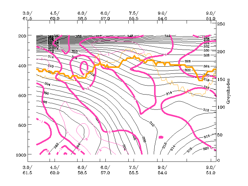
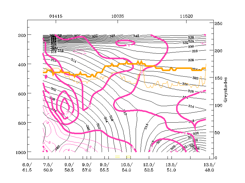
02 June 2000/18.00 UTC - Vertical cross section; black: isentropes (ThetaE), magenta thin: divergence, magenta thick: convergence,
orange thin: IR pixel values, orange thick: WV pixel values
|
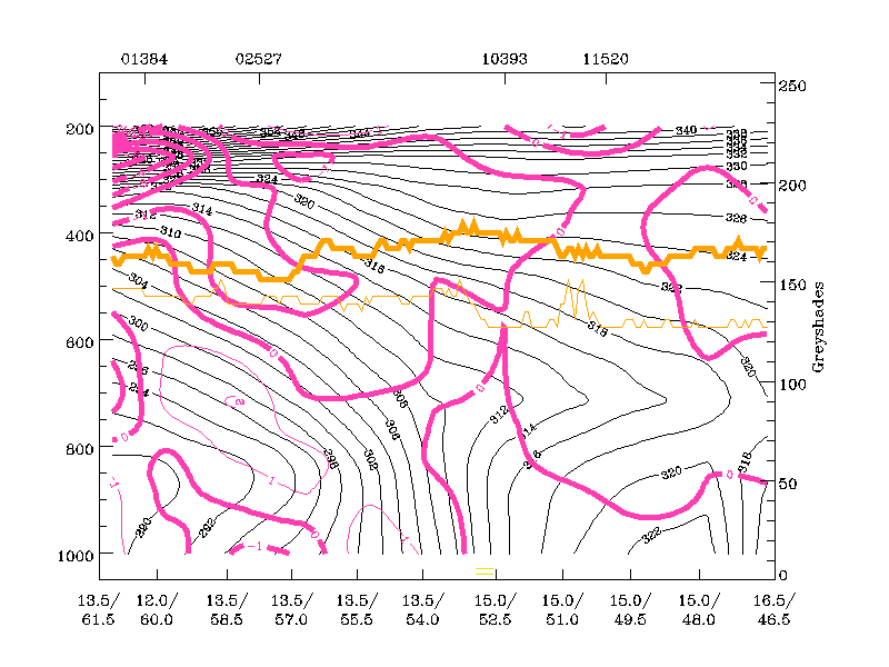
03 June 2000/00.00 UTC - Vertical cross section; black: isentropes (ThetaE), magenta thin: divergence, magenta thick: convergence,
orange thin: IR pixel values, orange thick: WV pixel values
|
|
|
|
|
|
03 June 2000/06.00 UTC - Vertical cross section; black: isentropes (ThetaE), magenta thin: divergence, magenta thick: convergence,
orange thin: IR pixel values, orange thick: WV pixel values
|
|
The above sequence of vertical cross sections shows the distribution of divergence and convergence over 12 hours and, in particular, a pronounced zone of divergence below and within the frontal surface. In contrast, convergence above the frontal zone does not imply a classic Cold Front, however, there is a relationship with previously mentioned paramteter fields.