Synoptic Situation : satellite overview, radar images and basic numerical parameters
The surface synoptic chart for 26th May 2006 at 00 UTC shows a shallow low with the frontal system approaching Turkey from the north-west. The approach of the front can be monitored in a sequence of METEOSAT 8 colour enhanced IR 10.8 images at 30 minute intervals. During the time period, several processes can be followed. First of all, the convection ahead of the frontal cloud band appeared. Its most distinct feature is the strong convective system which developed in the evening of the 25th May north-west of the Ankara area and died out during the night. Towards the midday of 26th, the second convective system within the frontal band evolved, reaching its mature stage in the late afternoon. In the meantime, a distinct line of prefrontal convergence can be noticed. The third feature of this study, a separate system over the eastern Turkey, is a combination of the daytime convection and the convection caused by an upper level low.
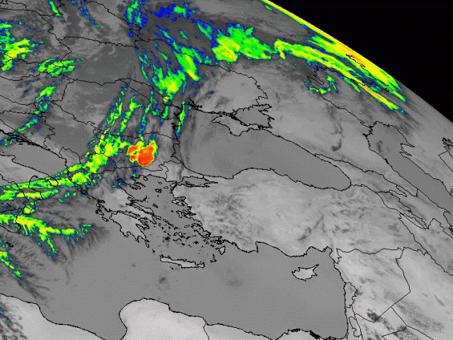
25 May 2006, 1200 UTC - Meteosat 8 Enhanced IR10.8 image
|
|
Satellite overview
Meteosat 8 IR 10.8 µm : time sequence
In this chapter a sequence of Meteosat 8 infrared 10.8 µm images at 1 hour intervals is shown.
Meteosat 8 enhanced IR 10.8 µm : selected time sequence
This chapter shows the same images as the previous one, only in this sequence images are colour enhanced. This enhancement enables us to study the most important cloud features and the temperature of the cloud tops in more detail.
Meteosat 8 WV 6.2 µm : time sequence
This chapter gives an idea of the upper air humidity and dynamics using Meteosat 8 WV 6.2 µm channel.
Meteosat 8 composite RGB - Day Microphysical Summer : selected time sequence
Day time convection can be easily detected by using RGB composites, especially "Day Microphysical Summer". It is
a composite of visible channel
0.8 µm, solar component of infrared 3.9 µm channel and the infrared 10.8 µm channel. This composite helps to identify
the cloud structure and
the dynamics of processes.
More details about RGB composites and their interpretation can be found in the “MSG Interpretation guide”.
Meteosat 8 composite RGB - Severe Convection : selected time sequence
In this chapter the convective development is studied using the so-called "Severe Convection RGB". On red, green and blue, the brightness temperature differences (BTD) of two water vapour channels 6.2 µm and 7.3 µm, two infrared channels 3.9 µm and 10.8 µm and two visible channels 1.6 µm and 0.6 µm are pictured, respectively. This composite is suitable for the detection of convection and is able to discriminate between young and mature convective cells.
Radar images
Radar images - radar reflectivity in dBz : time sequence
Severe convective development over central Turkey during 26th May is shown by radar images. Hail is often observed in association with severe development, but it can not be detected using satellite imagery. Weather radar appears as a valuable tool for the real-time detection of hail.
EUMeTrain would like to thank Firat Bestepe from Turkish State Meteorological Service for his help and providing us these images.
Relevant radiosoundings In this chapter a vertical profile of the atmosphere is analysed by the data from radiosonde measurements.
Basic synoptic parameters
Meteosat 8 IR 10.8 µm and Geopotential Height 1000 hPa
Cloud configurations in satellite images combined with the basic field of surface pressure represented by geopotential height at 1000 hPa are shown here at 6-hourly intervals.Meteosat 8 IR 10.8 µm and Geopotential Height 300 hPa
In this chapter the cloud configurations seen in IR10.8 µm satellite images are related to the basic field of upper level height at 300 hPa, in 6-hourly sequences are shown.
Summary
The set of satellite images showed a series of severe convective developments
close to and over Turkey during the 25th and 26th May. While cold front was
approaching Turkey from the north-west, several processes could be followed. The
preface to the case was the severe convective development within a cold front
over Bulgaria and Greece during the afternoon and evening of May 25th. The
series continued with strong night-time convection induced by the orography
ahead of the cold front near the Ankara region. The culmination of this case
study was the severe convective development which took place over Turkey within
the cold front during the 26th May. At the same time convection caused by the
upper level low over Eastern Turkey was observed.
The set of WV6.2 µm images showed that most of the convective cells
developed at the boundaries of the WV dark stripes. The set of RGB composites
showed the structure and the life cycle of the convective cells. Different
colours enable distinction between water and ice as well as between large and
small cloud particles and give the information about the development stage of a
particular cell.
Severe convective development over Turkey was also depicted by the set of
radar images. The high reflectivity was often accompanied with hail reports, but
unfortunately the data was not disposable. The
vertical structure of the atmosphere was shown by radiosonde data and discussed
with help of stability indices which showed mainly
unstable stratification of the atmosphere.
The field of the basic synoptic parameters showed the approach
and passage of the cold front followed by the upper
level trough. The upper level low ahead, which played
an important role in the convective development over Eastern Turkey, could be
observed in the field of geopotential height at 300 hPa.
In the next chapter the development will be studied using derived parameters.