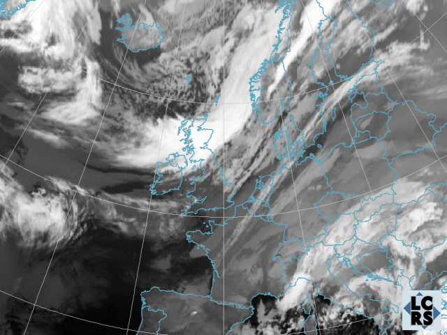
In the first IR image we see a broad cold front band stretching from Great Britain to Norway. Behind this cold front, cold air masses with cellular cloudiness can be noticed.
The cold front band moves south-eastwards. In the cold area behind the front the cloudiness increases and shows enhanced cumuli at this time.
A comma-like cloud structure in the cold air develops out of the enhanced cumuli northeast of Scotland. The comma-like structure is clearly separated from the cold front by a darker zone. Some mid-level cloudiness with warmer cloud tops can be observed here. This area is called the shallow moist zone. because of moist air in the lower layers of the troposphere and dry air above due to subsidence. Due to potentially unstable stratification of the troposphere convection is to be expected in this area.
Comma cloudiness in the North Sea is getting more distinct. This situation marks the Initial Stage of the instant occlusion process, also referred as the Pre-Mergin Stage. In the shallow moist zone behind the cold front increased cloud development takes place.
Another zone of cloudiness at the back side of the cold front with lower cloud tops develops, characterizing an induced wave. The comma-like system moves closer to the cold front. The cloud tops of the comma are darker than the cloud tops of the cold front. This is caused by the influence of upper dry air situated on the cyclonic side of the jet. The lowest cloud tops are found in the area close to the cold front.
The instant occlusion reaches the merging stage of the development. However, comma cloud and cold front are still separated by a shallow moist zone.
The cold front shows a wave bulge on its backside. The comma structure keeps growing and is characterized by cellular appearance indicating upward motion in this area.
South of the comma a split front character can be noticed probably induced by the influence of upper dry air at the cyclonic side of the jet.
Over the North Sea a hint to a wave development can be recognised (bulge shape at the frontal clouds'rear edge). The comma keeps growing and takes on an enhanced cyclonic form. It moves eastwards approaching the cold front.
At 21 UTC the comma seems to merge with the cold front but is still separated by a narrow darker zone.
The IR image on 25 Nov at 00 UTC shows the typical appearance of an occlusion cloud spiral. The comma has merged completely with the cold front. This time step can be referred to as the Mature Stage of the development. Over East Europe a high pressure system blocked the cyclone and upper wind speed decreases. Therefore the centre of the low will be nearly stationary for appoximately 24 hours over the Netherlands and NW Germany. This cloud configuration in connection with cold air masses leads to enhanced snow fall in these areas.
The life-cycle of the cloud spiral can be observed. The surface low centre did not move significantly during the last 3 hours.
The surface low centre remained almost stationary during the last 3 hours. High extending and compact clouds can be seen over many parts of the Netherlands and Western Germany .
No significant changes during the last 3 hours occured.
The cloud spiral is more clearly to be seen in this image. The position of the surface low remained almost the same.
The surface low moved slightly to the West. However, the general situation did not change significantly. Parts of the Netherlands and West Germany were influenced by compact clouds.
The surface low continued moving slowly to the West.
During the last 3 hours the surface low and the compact clouds moved slowly to the South. Dissolution of cloudiness of the northern parts of the Netherlands indicates the ending of this severe weather situation.
Cloud dissolution and the weakening of the spiral mark the end of this weather situation. WV images and Airmass RGB in the next chapters will demonstrate the role of the jet and upper air processes.