The Norwegian Cyclone Model versus the Shapiro-Keyser Cyclone Model
From the satellite perspective, both cyclone types look very similar. At first glance and from the evolution of the cloud pattern during the life cycle, no major differences can be observed. However, many Shapiro-Keyser cyclones show a rapid deepening of the surface low during their development phase and can therefore be characterized as having Rapid Cyclogenesis. Another difference is that Norwegian cyclones often form in low-index situations while Shapiro-Keyser cyclones form in high-index situations. The differences between the cyclone types can be best observed when we make use of NWP fields to analyze the ongoing physical processes.
Let us start with a side-by-side comparison of the two cyclone models over their life cycle.
| Norwegian cyclone model | Shapiro-Keyser cyclone model |
|---|---|
|
History: The classical Norwegian Cyclone Model was developed at the beginning of the last century using a coastal network of observation sites. From these ground measurements, a model describing the formation of a low-pressure system, as well as the interaction of warm and cold air masses, was developed. The early theory showed weaknesses in explaining the very early stages of cyclogenesis as the triggering mechanisms from the upper troposphere, and the dynamics therein, were not yet known. The model was significantly extended, mainly during the second world war as upper-air measurements from planes and radiosondes became available and the jet streams were discovered. |
History: The Shapiro-Keyser cyclone model was developed in the late 1980s, benefitting from data made available by meteorological satellites and numerical model simulations. This conceptual model was named after the authors of the study that first presented it (M. A. Shapiro and D. Keyser, 1990). The authors discovered that, for some types of cyclogenesis, the meteorological data seemed not to conform to the classical Norwegian cyclone model, in which the occlusion process results from a merging of the cold and the warm front. Instead, they observed a cold frontal fracture at the place where the cold front should smoothly turn into the warm front. |
Initial stage:
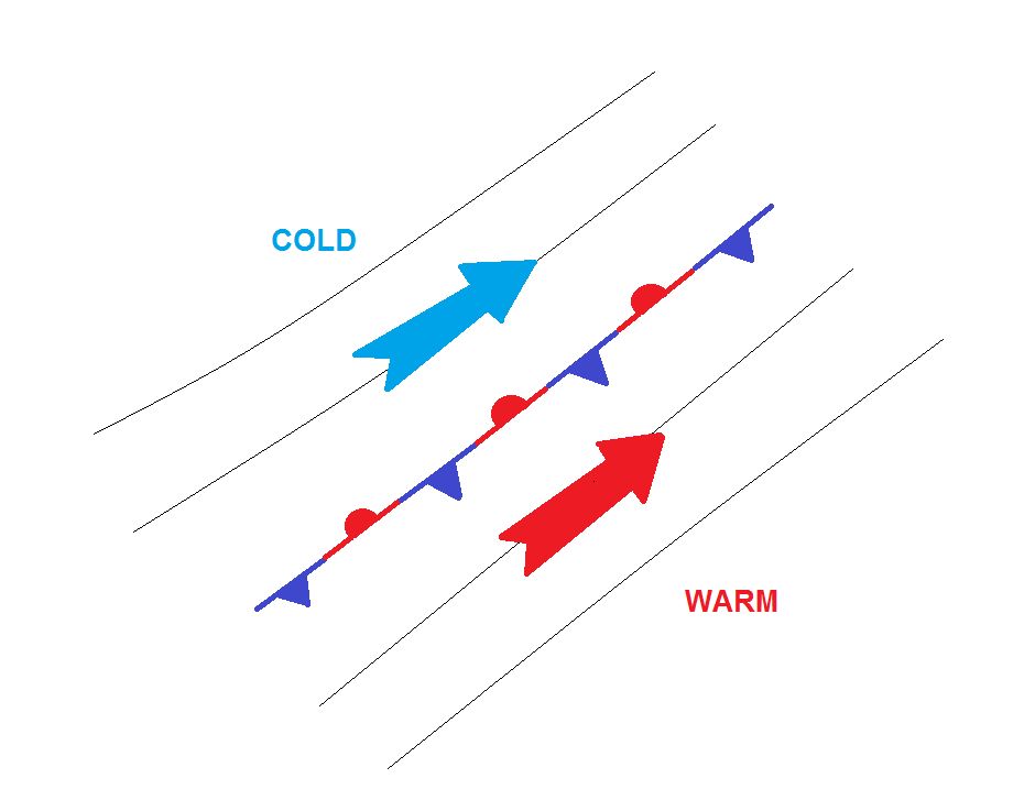
A pre-existing baroclinic boundary or slowly moving front separating colder from warmer air masses is a precondition for the development of a mid-latitude cyclone. On both sides, the air is moving parallel to the front; there is no temperature advection. A perturbation occurs at the intersection of the two air masses, causing a wave pattern to develop.
Developing wave:
A surface low pressure starts building and a cyclonic circulation around the low starts to advect cold air to the south and warm air to the north (in the northern hemisphere). The so far stationary front organizes into a cold and a warm front.
|
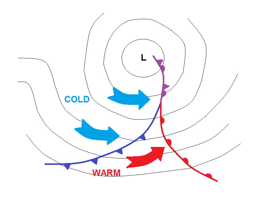
Intensification stage: Norwegian cyclone
As the pressure drops at the low center, the warm and cold front become better organized. The increase of the pressure gradient leads to stronger winds, which increase warm and cold advection. |
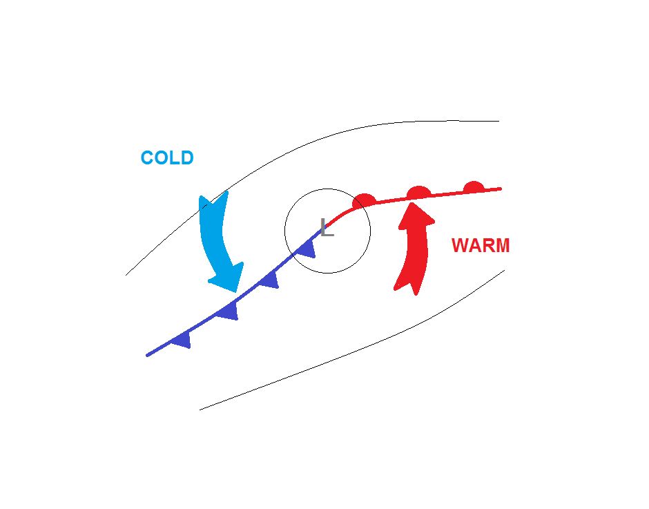
Intensification stage: Shapiro-Keyser cyclone
After the wave has formed, warm air continues to protrude northward and starts filling the center of the deepening low. Cold air continues moving rapidly towards the southeast and the cold front detaches from the warm front (cold frontal fracture). In reality, the cold and warm front are still connected by an inactive air mass boundary that is usually not drawn on synoptic charts (grey line). |
|
Maturity stage: Norwegian cyclone
The surface low reaches its minimum pressure and the axis of the low becomes vertical, i.e., the lowest pressure regions in the upper levels are now directly above the surface low. The faster moving cold front starts to catch up the warm front, like a closing zip, forming an occlusion. The denser cold air behind the cold front moves faster than the warmer air ahead of it. Most of the kinetic energy of the warm front is dissipated by it being lifted on top of the cold air. The less dense warm air has only a minor impact on the denser cold air, whereas the denser cold air has a strong impact on the warm air in the warm sector, which is rapidly displaced and lifted above the cold air. This is the main reason why cold fronts generally move much faster than warm fronts and catch them up. As the cold front catches up the warm front, the warm air between the two fronts (known as the warm sector) is lifted to higher levels, often producing large amounts of rain. |
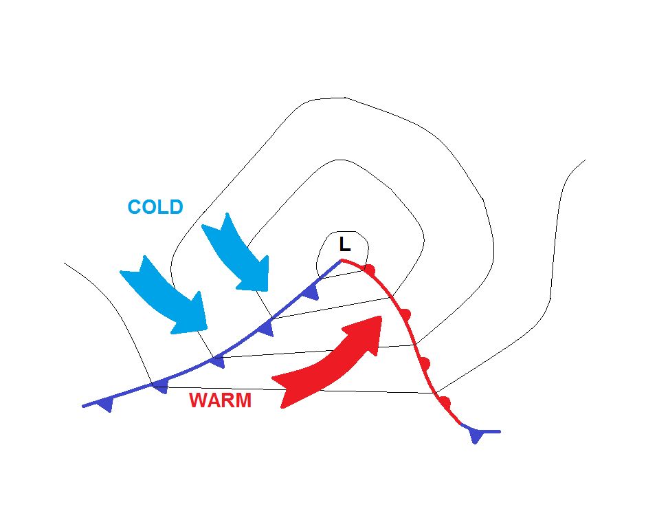
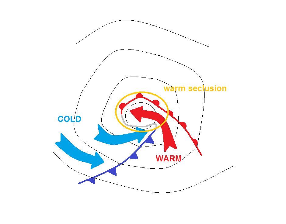
Maturity stage: Shapiro-Keyser cyclone
Unlike the Norwegian cyclone type, no occlusion forms during the maturity stage of the Shapiro-Keyser cyclone. Instead, an air mass boundary delimits the warm core from the cold air in the northeast, showing many similarities to a warm front. In fact, where we would expect the occlusion on the synoptic chart, a bent-back warm front is drawn. During maturity stage, cold air from behind the cold front starts wrapping around the warm core of the cyclone and forms a warm seclusion. The cold front successively approaches the warm front, forming the classical T-bone pattern often observed with Shapiro-Keyser cyclones. |
|
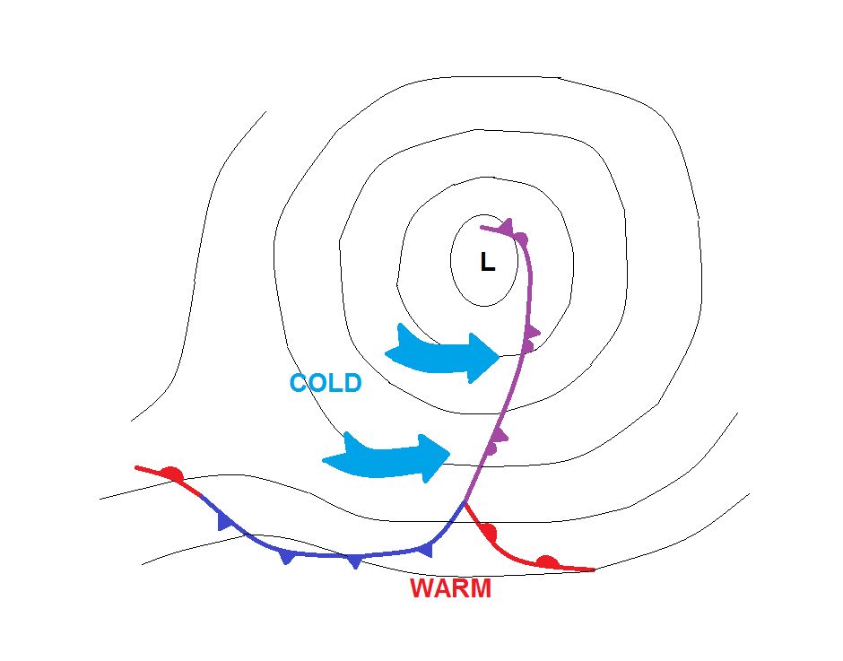
Dissipating stage: Norwegian cyclone
The low-pressure system starts to fill and the center pressure increases. In this classic example, warm air from the warm sector is lifted to higher levels and wraps around the low center (see the conveyor belt theory). This leads to a decrease in the temperature gradient and to a temperature adjustment between the cold and warm air masses. Note that the surface low has constantly remained within the cold air mass: hence, we speak of a cold core cyclone. In some cases, the upper-level trough starts to tear off and the dissipating cyclone moves southward. Due to friction, the surface low fills rapidly and a cold region remains at higher atmospheric levels. This so-called “cut-off process” can lead to the formation of an upper-level low. |
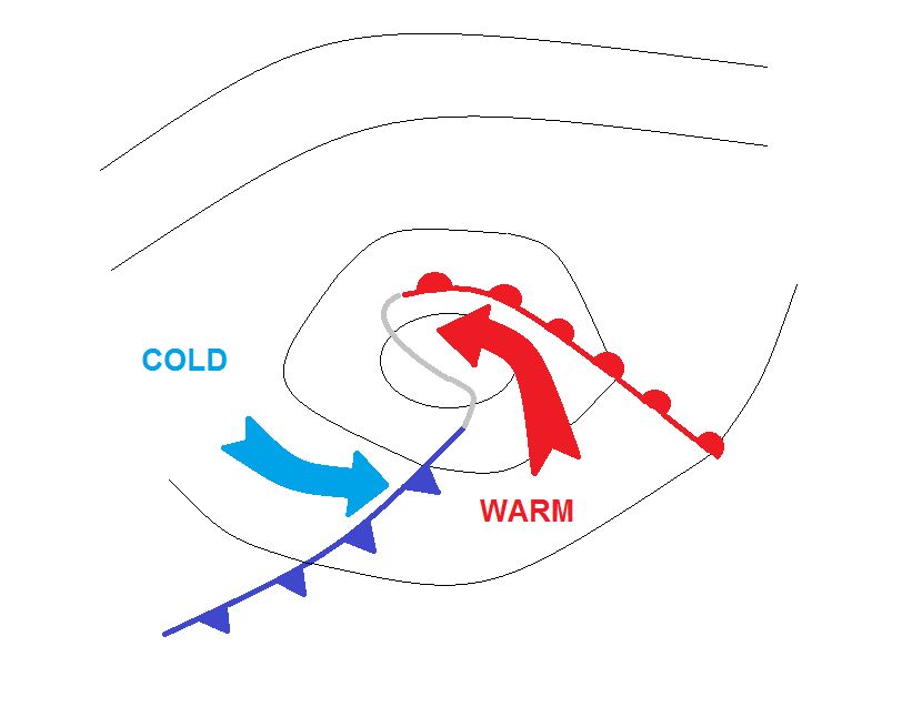
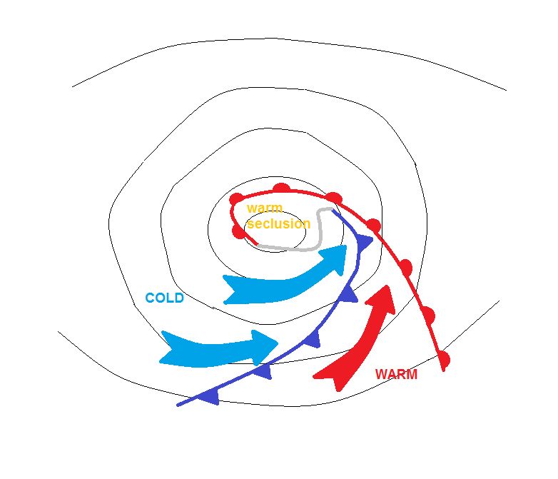
Dissipating stage: Shapiro-Keyser cyclone
The dissipating stage of the Shapiro-Keyser cyclone looks very similar to the final stage of the Norwegian cyclone in satellite imagery. The warm seclusion decouples from the warm sector while cold air from behind the cold front wraps around the warm core of the cyclone. When cold air wraps around the warm core, the final situation is similar to the Norwegian cyclone type, in that the cold front merges with the warm front and forms an occlusion. |
|
Final remarks: While the Norwegian cyclones have a cold core with an occlusion cloud band, Shapiro-Keyser cyclones have a warm core with cold air wrapping around. |
Final remarks: Shapiro-Keyser cyclones are most frequently observed over the oceans. They often show a strong development and a rapid deepening of the surface low, for which reason they often fulfil the criterion of Rapid Cyclogenesis. |
Quiz:
Question 1:
Which of the following development stages are very similar for Norwegian and Shapiro-Keyser cyclones? Choose all that apply.
Question 2:
What are the main differences between the Norwegian and the Shapiro-Keyser cyclone model? Choose all that apply.