Table of Contents
- Introduction and Conceptual Models for 29 July 1997/06.00 UTC
- Overview of satellite features and conceptual models
- Frontal diagnosis
- Diagnosis of the western cloud feature - Conceptual model "Front Intensification by Jet Crossing"
- Diagnosis of the eastern cloud feature - Conceptual models "Convergence Cloudiness" and "Cumulonimbus (Cb) and Mesoscale Convective System (MCS)"
- Diagnosis for 06.00 UTC with help of vertical cross sections
- Very Short Range Forecast (VSRF) till 18.00 UTC
- Conceptual Models - Diagnosis for 29 July 1997/12.00 UTC
- Conceptual Models - Diagnosis for 29 July 1997/18.00 UTC
29 July 1997 - Overview Of Satellite Features And Conceptual Models
|
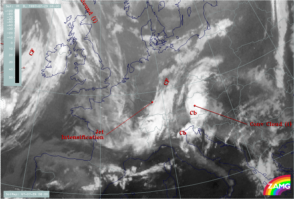
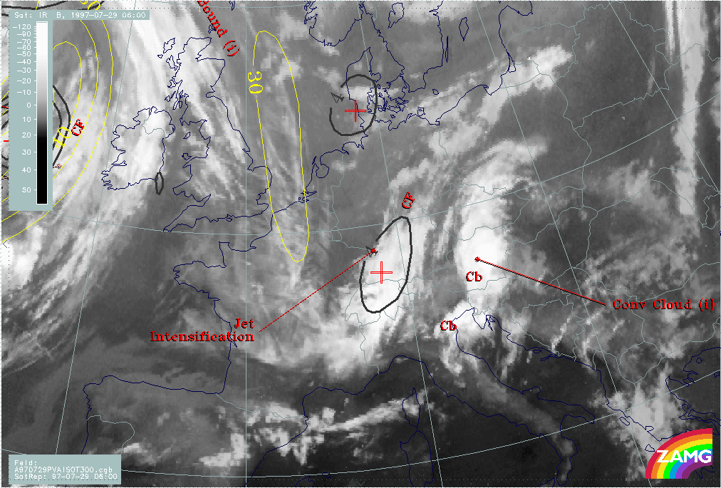
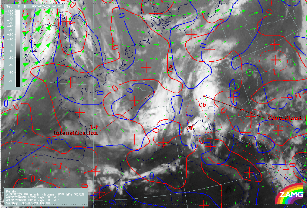
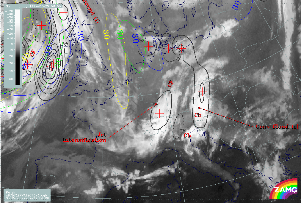
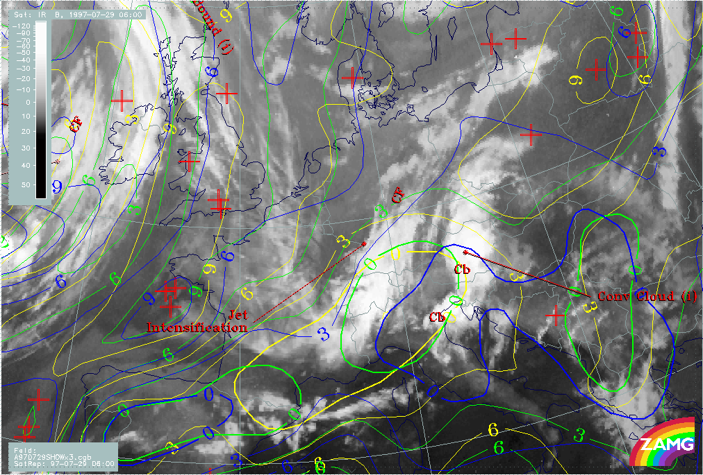
29 July 1997/06.00 UTC - Meteosat IR image; SatRep overlay: names of conceptual models
|
|
|
The image above shows the initial situation on 29 July at 06.00 UTC: the following cloud systems can be diagnosed in the Central and Western European areas:
- A band-like cloud system extending from the west Alps across Switzerland to south Germany (compare Diagnosis of the western cloud feature - Conceptual model "Front Intensification by Jet Crossing" ); the part over Germany can be identified as an area of cloud intensification in the left exit region of a jet streak (in short form "Jet Intensification") (compare Conceptual Models: Front Intensification by Jet Crossing )
- A band-like cloud system extending from the north Adriatic Sea across Slovenia and east Austria to the Czech Republic and south Poland (compare Diagnosis of the eastern cloud feature - Conceptual models "Convergence Cloudiness" and "Cumulonimbus (Cb) and Mesoscale Convective System (MCS)" ); it can be identified as "Convergence Cloudiness" (compare Conceptual Models: Convergence Cloudiness ) with two areas of thunderstorms (Cb) embedded
- A Cold Front "CF" (compare Conceptual Models: Cold Front ) over the Atlantic approaching the British Isles
- Fibrous cloudiness extending from the North Sea into France; this feature is indicative of cloudiness on the anticyclonic side of the jet axis and supports the initial diagnosis (compare Conceptual Models: Jet Cloudiness (Fibre) )
29 July 1997 - Frontal Diagnosis
|
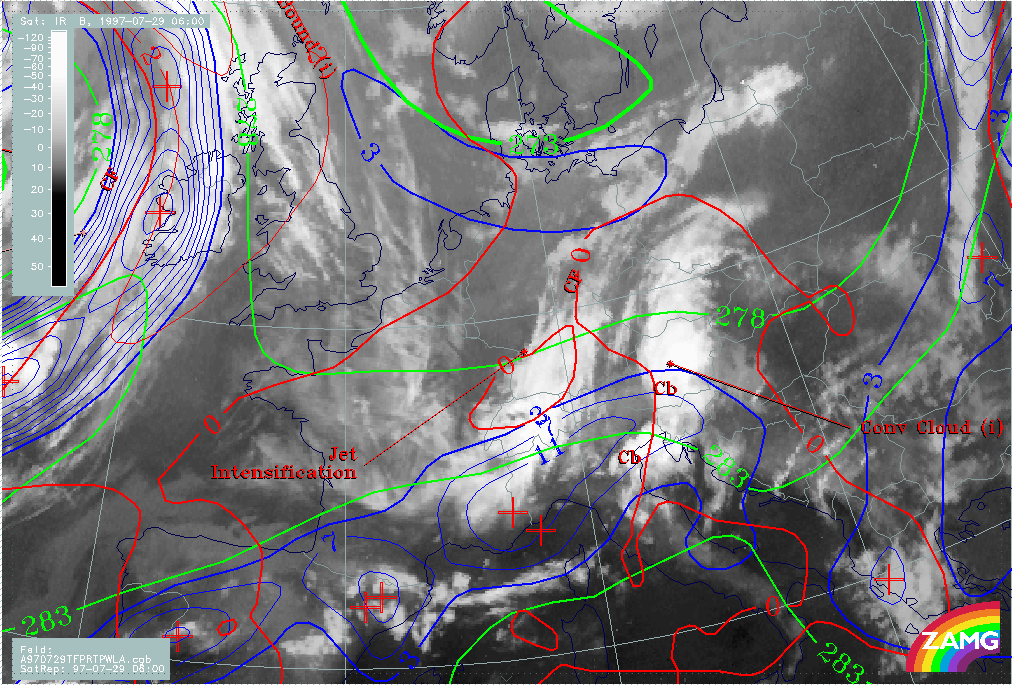
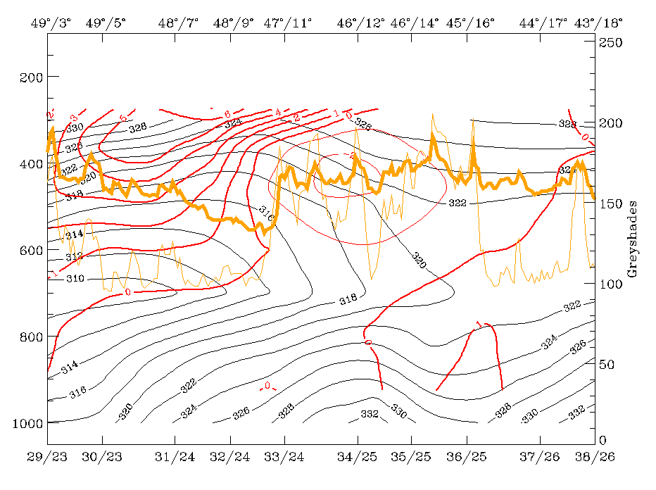
29 July 1997/06.00 UTC - Meteosat IR image; blue: thermal front parameter (TFP) 500/850 hPa, green: equivalent thickness 500/850 hPa,
red: temparature advection - WA 1000 hPa; SatRep overlay: names of conceptual models
|
|
|
The image above shows a combination of numerical parameters typical for front identification:
- Equivalent thickness 500/850 hPa
- Temperature advection (TA) especially warm advection (WA) 500/1000 hPa
- Thermal front parameter (TFP) 500/850 hPa
While these parameters support the frontal character of the cloud band on the western boundary of the image, the two cloud bands in the centre with a north-south orientation are not at all frontal cloud bands. A rather weak thickness gradient crosses the cloud band perpendicularly, WA and CA are rather weak and without any distinct relation to either of the two cloud systems, and the TFP extends in a more west-east direction from the Pyrenees across north Italy to Slovenia and south Austria.
This is a typical situation where the TFP characterises an air mass boundary immediately south of the Alpine mountain ranges separating the warm air mass in the Mediterranean from the colder one north of the Alps. The two north-south oriented cloud bands are to a large extent on the northern side of the air mass boundary and have a different physical background.
|
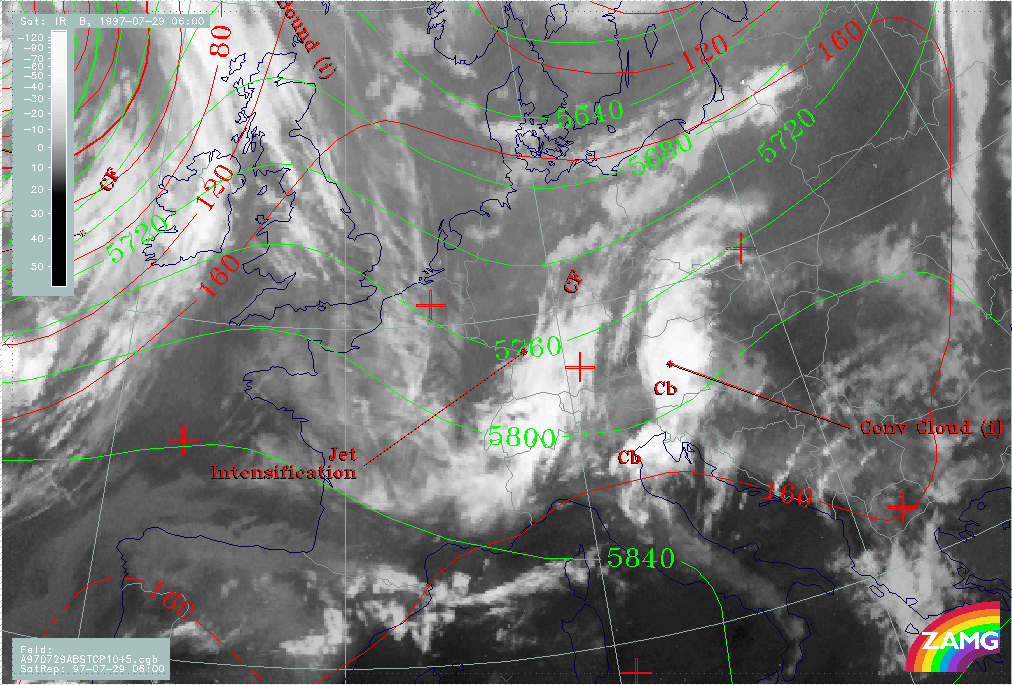
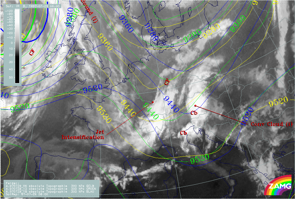
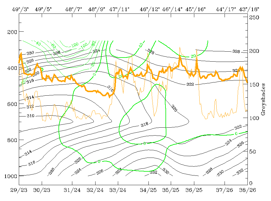
29 July 1997/06.00 UTC - Meteosat IR image; red: height contours 1000 hPa, green: height contours 500 hPa; SatRep overlay: names of
conceptual models
|
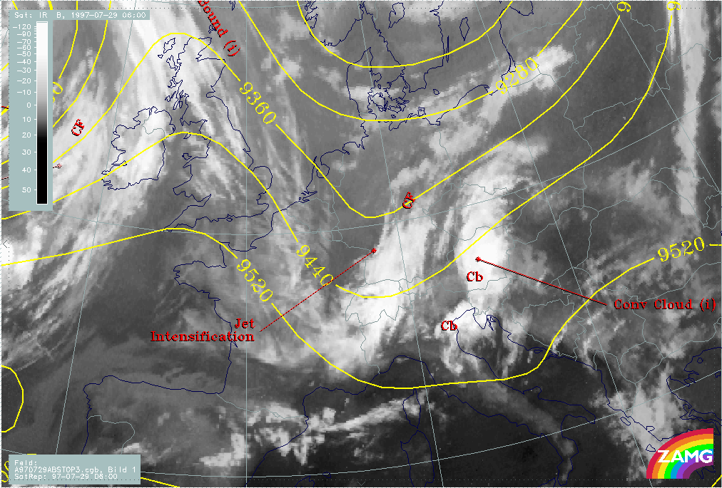
29 July 1997/06.00 UTC - Meteosat IR image; yellow: height contours 300 hPa; SatRep overlay: names of conceptual models
|
|
|
The images above show the height contours close to the surface (1000 hPa, red), at 500 hPa (green) and at 300 hPa (yellow). While there is an extended but unstructured high pressure zone at 1000 hPa, the upper levels do show a pronounced trough which becomes even more distinct on the higher surfaces and is clearly related to the rear side of the western of the two cloud bands.
This relationship indicates also that what occurs in the upper levels has an important influence on cloud systems.
29 July 1997 - Diagnosis Of The Western Cloud Feature - Conceptual Model "Front Intensification By Jet Crossing"
|
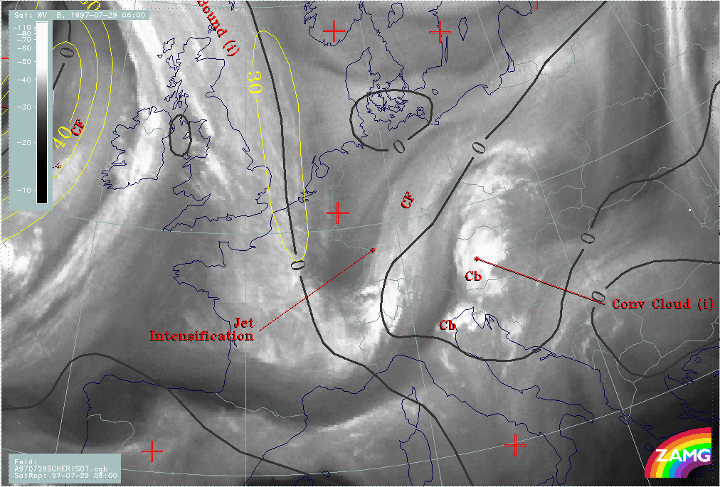
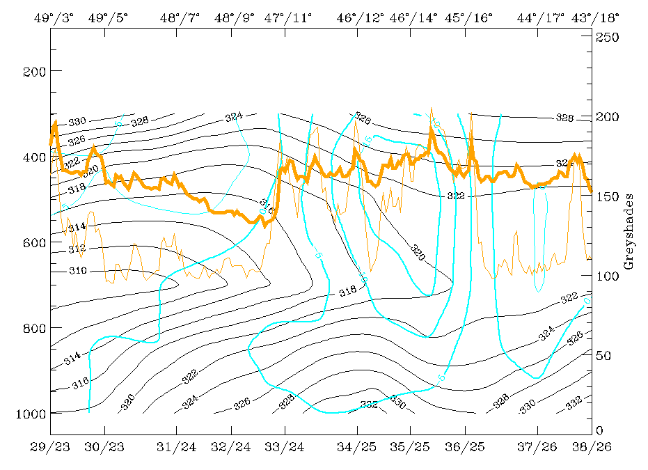
29 July 1997/06.00 UTC - Meteosat WV image; yellow: isotachs 300 hPa, black: shear vorticity 300 hPa; SatRep overlay: names of
conceptual models
|
|
|
The image above contains some jet streak features superimposed on the WV image. The black line is the zeroline of shear vorticity at 300 hPa and represents the jet axis, the yellow lines are isotachs at 300 hPa. From the WV image a first guess about the jet axis can be found with help of the fibres extending from the North Sea into France, and also with help of the darker areas on the cyclonic side of the jet axis representing sinking dry air. Of special interest is the darkest area centred over east France (around 48N/07E) which represents dry air on the rear side of the western cloud band. The numerical model is in relatively good agreement with the cloud features concerning the jet axis (some small misplacements between cloud fibre and zeroline can be noticed but are of minor importance).
|
29 July 1997/06.00 UTC - Meteosat IR image; black: positive vorticity advection (PVA) 300 hPa, yellow: isotachs 300 hPa; SatRep
overlay: names of conceptual models
|
29 July 1997/06.00 UTC - Meteosat IR image; yellow: isotachs 300 hPa, blue: shear vorticity 300 hPa, brown: curvature vorticity 300
hPa; SatRep overlay: names of conceptual models
|
|
|
|
|
|
29 July 1997/06.00 UTC - Meteosat IR image; blue: shear vorticity 500 hPa, dark red: curvature vorticity 500 hPa; SatRep overlay: names
of conceptual models
|
|
The top left image adds information about the relation between jet streak, its left exit region and the cloudiness with help of the isotachs (yellow) and the PVA maximum (black) at 300 hPa. Although the isotach maximum of 30 m/s is rather weak, there is a maximum of PVA in the left exit region in exact agreement with the intensified cloud area over Switzerland and south Germany. In the top right image the contributions of the jet streak and the upper level trough can be evaluated with help of shear (blue) and curvature (brown) vorticity. Clearly both effects are important: there is a maximum of shear as well as of curvature vorticity connected with the PVA maximum. From the bottom left image, which gives similar information for 500 hPa, it can clearly be seen that at this level only the propagating trough contributes to the PVA maximum and the cloudiness. Therefore at the higher level of 300 hPa the propagating jet streak enhances PVA and cloudiness.
From these considerations the western cloud feature can be diagnosed as cloudiness produced and maintained by processes in the upper levels: a propagating upper level trough existing in a thick layer and a jet streak with a left exit region only in the higher layers.
29 July 1997 - Diagnosis Of The Eastern Cloud Feature - Conceptual Models "Convergence Cloudiness" And "Cumulonimbus (Cb) And Mesoscale Convective System (MCS)"
|
29 July 1997/06.00 UTC - Meteosat WV image; red: divergence 850 hPa, blue: divergence 700 hPa; green: wind vectors 850 hPa; SatRep
overlay: names of conceptual models
|
|
|
In the image above, divergence fields at 850 hPa (red) and 700 hPa (blue) as well as wind vectors at 850 hPa (cyan) are superimposed. The dashed lines indicate convergence in both levels, which means that the biggest part of the cloud band exists in an area where there is a rather thick layer of convergence leading to upward motion. It has to be remembered that this convergence area is not connected with frontal characteristics there. The wind vectors showing a pronounced confluent stream hint at the reasons for convergence in this area.
A much more convenient tool for the detection of non-frontal Convergence Cloudiness are vertical cross sections which are described in the next chapter (compare Diagnosis for 06.00 UTC with help of vertical cross sections ).
|
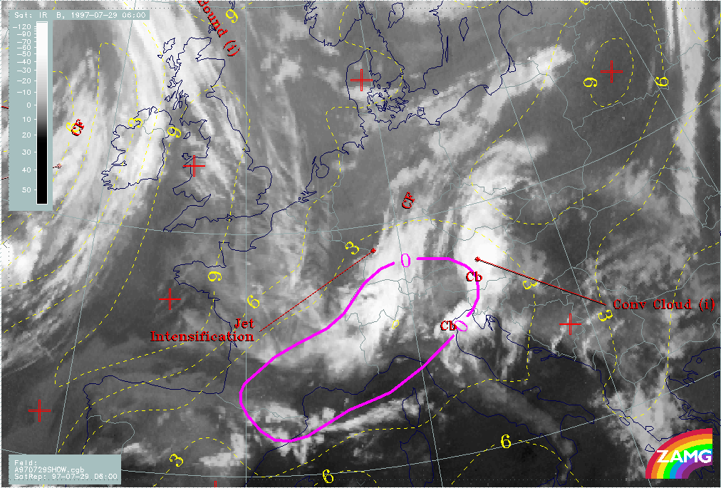
29 July 1997/06.00 UTC - Meteosat WV image; yellow: Showalter index 500/850 hPa, magenta: zero line of Showalter index 500/850 hPa;
SatRep overlay: names of conceptual models
|
|
|
Additional information about the embedded convective cloud cells (Cb) with the help of a stability parameter, the Showalter index, can be found in the image above. Showalter indices below 3 units represent areas with high probability of thunderstorm development; below 0 severe thunderstorms are very likely. There is a big area where these conditions are fulfilled extending from north Spain to east Austria, Slovenia and Croatia. It is a typical situation that the Showalter index describes areas of high thunderstorm probability very well but only on a larger rather than a local scale. Where the thunderstorm complexes actually develop within these large scale areas is dependent on additional local scale conditions.
29 July 1997 - Diagnosis For 06.00 UTC With Help Of Vertical Cross Sections
|
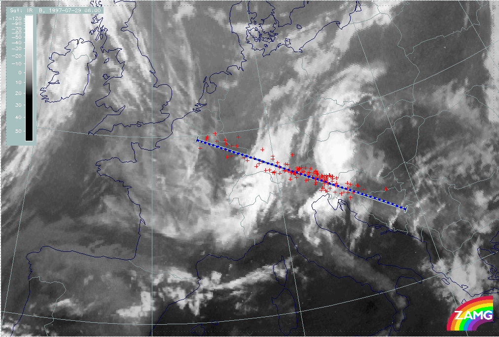
29 July 1997/06.00 UTC - Meteosat IR image; red: weather observation stations; position of vertical cross section indicated
|
|
|
Vertical cross sections are an additional, different look into the physical-meteorological state of the troposphere which sometimes enhances or even detects special situations. The image above shows the course of the chosen vertical cross section from France across both cloud systems discussed before, i.e. across the area of Jet Intensification (compare Conceptual Models: Front Intensification by Jet Crossing ) in the western, and the area of convergence and Cb activity in the eastern cloud system. The red crosses represent weather stations within a pre-selected distance from the cross section line which are projected vertically on this line for a better representation of the situation at the surface. The grid in cyan and black is related to grid-points of the numerical model of ECMWF used for these purposes.
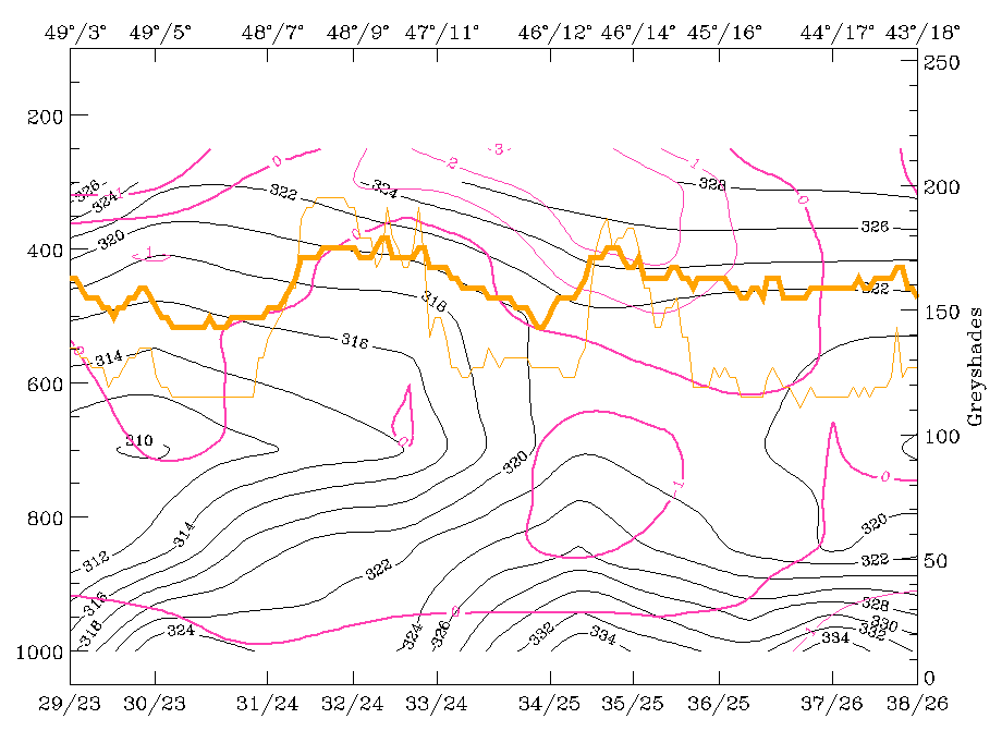
|
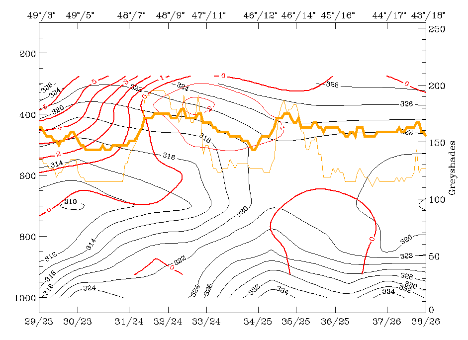
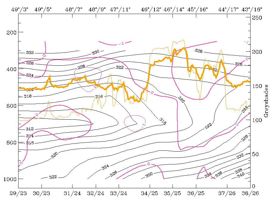
29 July 1997/06.00 UTC - Vertical cross section; black: isentropes (ThetaE), red thin: temperature advection - CA, red thick:
temperature advection - WA, orange thin: IR pixel values, orange thick: WV pixel values
|
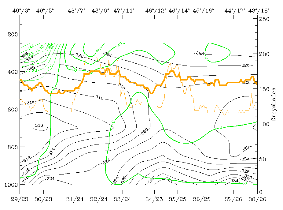
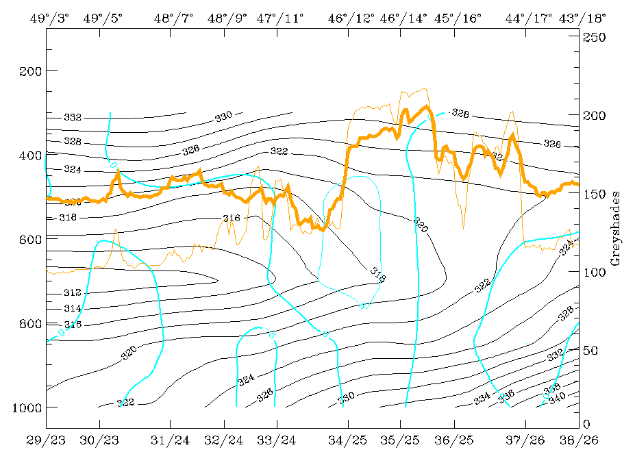
29 July 1997/06.00 UTC - Vertical cross section; black: isentropes (ThetaE), magenta thin: divergence, magenta thick: convergence,
orange thin: IR pixel values, orange thick: WV pixel values
|
|
|
|
|
|
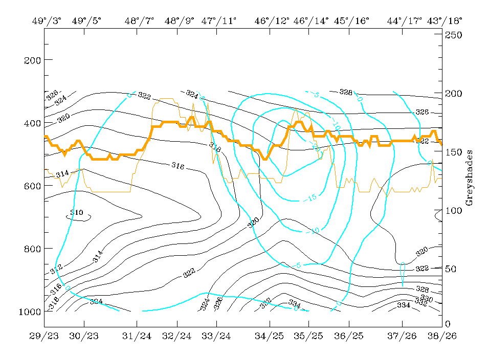
29 July 1997/06.00 UTC - Vertical cross section; black: isentropes (ThetaE), green thick: vorticity advection - PVA, green thin:
vorticity advection - NVA, orange thin: IR pixel values, orange thick: WV pixel values
|
29 July 1997/06.00 UTC - Vertical cross section; cyan thick: vertical motion (omega) - upward motion, cyan thin: vertical motion
(omega) - downward motion, magenta thin: divergence, magenta thick: convergence, orange thin: IR pixel values, orange thick: WV pixel
values pixel values
|
The images above show the vertical distribution of relevant parameters for both cloud systems which show up as broad maxima of the orange lines: the western one around gridpoint 32/24, the eastern one around gridpoint 35/25. The most important facts are summarised as follows:
- There is no notable temperature advection in the top left image, especially in the eastern system, but two interesting facts can be
recognised:
- In the eastern system where there are thunderstorm events there is (weak) WA below and CA above, which is a typical configuration for instability
- The western system is under CA between 500 and 300 hPa, which fits well to the upper level trough situation described before.
- Both cloud systems are accompanied by configurations of isentropes which are typical for a very unstable troposphere; although isentropes do not reveal any normal frontal characteristics, there is a suggestion of a weak upper level Cold Front inclined downward from 300 to 400 hPa between the two cloud systems.
- Both cloud systems are also accompanied by convergence in a thick layer (right image top). In particular the eastern cloudiness, the Convergence Cloudiness (compare Conceptual Models: Convergence Cloudiness ), shows appreciable convergence between 900 and 500 hPa.
- A maximum of PVA at 300 hPa (left image bottom) is superimposed on the western cloud system and represents the PVA in the left exit region of the jet streak discussed in more detail previously (compare Diagnosis of the eastern cloud feature - Conceptual models "Convergence Cloudiness" and "Cumulonimbus (Cb) and Mesoscale Convective System (MCS)" and Conceptual Models: Front Intensification by Jet Crossing ).
- Although the whole area is an area of upward motion (right image bottom: negative values of omega) the main rising happens at this point of time with the eastern system in connection within the convergence there.
29 July 1997 - Very Short Range Forecast (VSRF) Till 18.00 UTC
|
29 July 1997/06.00 UTC - Meteosat IR image; yellow: thermal front parameter (TFP) 500/850 hPa 06.00 UTC, green: thermal front parameter
(TFP) 500/850 hPa 12.00 UTC, blue: thermal front parameter (TFP) 500/850 hPa 18.00 UTC
|
|
|
The propagation of the TFP (image above) from 06.00 UTC (yellow) to 12.00 UTC (green) and finally to 18.00 UTC (blue) shows the quick eastward displacement towards England of the Cold Front on the west side of the image.
The TFP south of the Alps, indicating merely an air mass boundary, remains constant with changes only in the eastern part between 12.00 UTC (green) and 18.00 UTC (blue).
|
29 July 1997/06.00 UTC - Meteosat IR image; yellow: isotachs 300 hPa 06.00 UTC, green: isotachs 300 hPa 12.00 UTC, blue: isotachs 300
hPa 18.00 UTC, black solid: positive vorticity advection (PVA) 300 hPa 06.00 UTC, black dashed: positive vorticity advection (PVA) 300
hPa 12.00 UTC, black solid: positive vorticity advection (PVA) 300 hPa 18.00 UTC
|
29 July 1997/06.00 UTC -Meteosat IR image; yellow: positive vorticity advection (PVA) 300 hPa 06.00 UTC, green: positive vorticity
advection (PVA) 300 hPa 12.00 UTC, blue: positive vorticity advection (PVA) 300 hPa 18.00 UTC
|
|
|
|
|
|
29 July 1997/06.00 UTC - Meteosat IR image; yellow: height contours 300 hPa 06.00 UTC, green: height contours 300 hPa 12.00 UTC, blue:
height contours 300 hPa 18.00 UTC
|
|
Completely different results can be inferred from the displacement of upper level features:
- The top left image shows the propagation of the PVA maximum at 300 hPa with a south-eastward displacement across west Austria to east Austria and Slovenia. The black lines enclose an area of more than 4 units.
- Looking at the complete PVA field (right image top) the intensity of the maximum shows up quite clearly.
- As not only the jet streak was responsible for development and intensification of the cloud system, the propagation of the upper level trough is also followed (left image bottom) showing a displacement of the trough from Germany - France at 06.00 UTC across Germany - W. Austria at 12.00 UTC to a position from Poland across east Austria and Slovenia to middle Italy. From this, a propagation of the conditions accompanying the western cloud system into the region of the eastern cloud system can be concluded.
|
29 July 1997/06.00 UTC - Meteosat IR image; yellow: divergence 850 hPa 06.00 UTC, green: divergence 850 hPa 12.00 UTC, blue: divergence
850 hPa 18.00 UTC
|
|
|
For the forecast of the eastern cloud system convergence at 850 hPa can be taken into account (image above). There is no notable change between 06.00 and 12.00 UTC, with further convergence in the area of east Austria and Slovenia but a small eastward shift as well as a decrease in intensity between 12.00 and 18.00 UTC.
From both evaluations a mergence of the two cloud systems can be forecast or, in other words, the superposition of the upper level trough and jet features on the eastern convergence zone is likely.
|
29 July 1997/06.00 UTC - Meteosat IR image; yellow: Showalter index 500/850 hPa 06.00 UTC, green: Showalter index 500/850 hPa 12.00
UTC, blue: Showalter index 500/850 hPa 18.00 UTC
|
|
|
The image above gives hints for the VSRF of lability with help of the Showalter index. Extended areas with high probability of thunderstorm development remain constant during the whole period; the most important result is that the area with Showalter <0 can be found more to the east for 18.00 UTC enclosing an area from south Austria across Slovenia and Croatia to Italy.
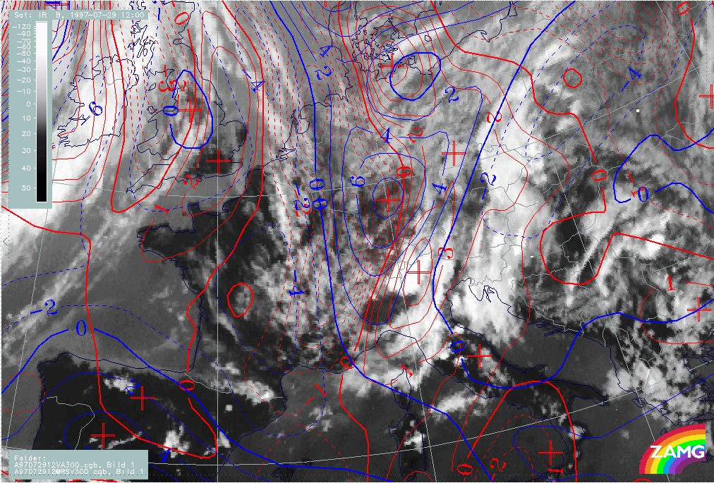
29 July 1997 - Satellite Features And Frontal Diagnosis For 12.00 UTC
|
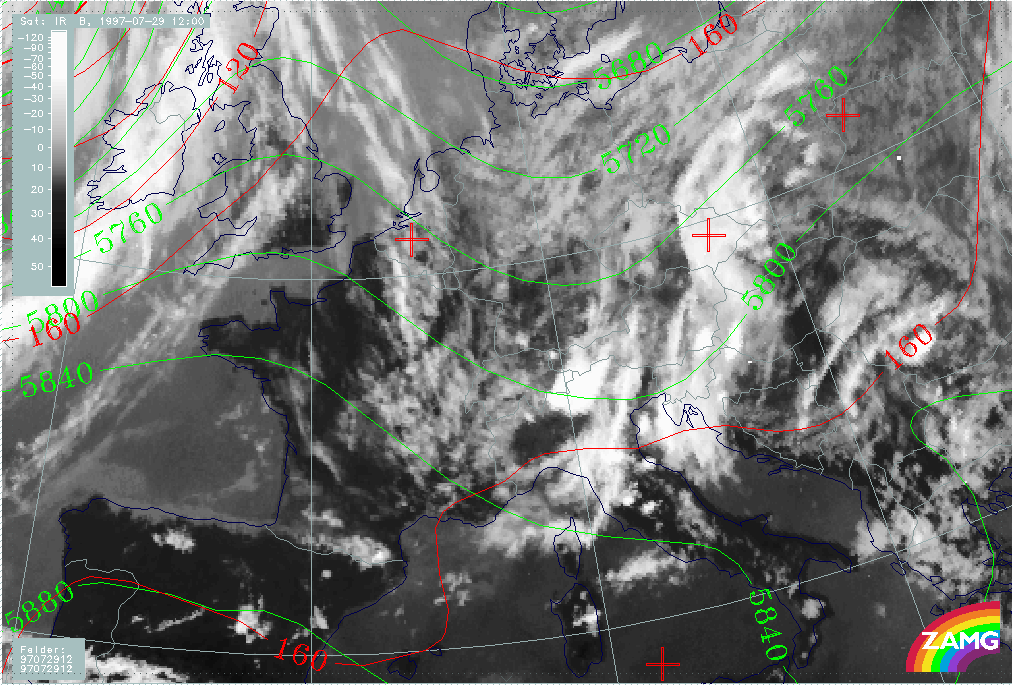
29 July 1997/12.00 UTC - Meteosat IR image; red: height contours 1000 hPa, green: height contours 500 hPa
|
|
|
The expected mergence of the two cloud systems can already be observed at 12.00 UTC. The image above shows the eastern cloud system nearly at the same location as at 06.00 UTC extending from the north Adriatic Sea across east Austria to Poland (compare Frontal Diagnosis ). The western system can now be located over west Austria and north Italy much closer to the eastern system. A thick convective cell has already developed over the Alps (centred around 46N/10E). Smaller cloud cells can be observed in the whole area especially over middle Italy.
As before there is a big area of high pressure at the surface (red lines) without any distinct gradients but a pronounced upper level trough (height contours at 300 hPa - yellow) connected with the western system.
|
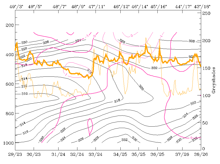
29 July 1997/12.00 UTC - Meteosat IR image; blue: thermal front parameter (TFP) 500/850 hPa, green: equivalent thickness 500/850 hPa,
red: temparature advection - WA 1000 hPa
|
|
|
Also same as before are the frontal characteristics (image above); there is no frontal character in the area under consideration but only an air mass boundary (compare Frontal Diagnosis ). An active front can be diagnosed for the cloud band at the western boundary of the image over the British Isles.
29 July 1997 - The Western Cloud System
|
29 July 1997/12.00 UTC - Meteosat IR image; red: vorticity advection 300 hPa
|
29 July 1997/12.00 UTC -Meteosat IR image; red: vorticity advection 300 hPa, blue: shear vorticity 300 hPa
|
|
|
As can be seen in the left image a distinct PVA maximum at 300 hPa coincides very well with the area of the western cloud system while there is only weak PVA for the eastern system. This PVA maximum is still connected with a maximum of shear vorticity (right image) representing a jet streak. The axis of this streak can also be diagnosed with help of the cloud fibres over the North Sea which are parallel and in good agreement with the zeroline of shear vorticity.
29 July 1997 - The Eastern Cloud System
|
29 July 1997/12.00 UTC - Meteosat IR image; red: divergence 850 hPa, blue: divergence 700 hPa, green: wind vectors 850 hPa
|
|
|
The eastern, relatively stationary cloud system is still accompanied by convergence in a thick layer (divergence at 850 hPa - red, divergence at 700 hPa - blue) and there is still the confluence of the wind vectors in the low layer (compare Diagnosis of the eastern cloud feature - Conceptual models "Convergence Cloudiness" and "Cumulonimbus (Cb) and Mesoscale Convective System (MCS)" ).
29 July 1997 - Instability 12.00 UTC
|
29 July 1997/12.00 UTC - Meteosat IR image; Showalter index 500/850 hPa, magenta: zero line of Showalter index 500/850 hPa
|
|
|
According to the image above, the area with the highest probability for thunderstorm development can be located over the Alps and Italy. This is exactly where a big thunderstorm complex has developed. But the area with Showalter indices below 3 units, which means high thunderstorm probability, is much more extended. Therefore for a diagnosis and prognosis of thunderstorm complexes, additional conditions and methods have to be investigated. There will be a separate chapter showing the thunderstorm development from 12.00 UTC onward.
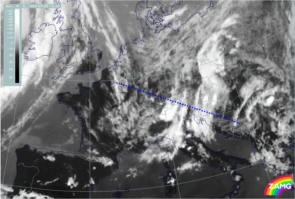
29 July 1997 - Diagnosis For 12.00 UTC With Help Of Vertical Cross Sections
|
29 July 1997/12.00 UTC - Meteosat IR image; position of vertical cross section indicated
|
|
|
|
|
29 July 1997/12.00 UTC - Vertical cross section; black: isentropes (ThetaE), red thin: temperature advection - CA, red thick:
temperature advection - WA, orange thin: IR pixel values, orange thick: WV pixel values
|
29 July 1997/12.00 UTC - Vertical cross section; black: isentropes (ThetaE), green thick: vorticity advection - PVA, green thin:
vorticity advection - NVA, orange thin: IR pixel values, orange thick: WV pixel values
|
|
|
|
|
|
29 July 1997/12.00 UTC - Vertical cross section; black: isentropes (ThetaE), magenta thin: divergence, magenta thick: convergence,
orange thin: IR pixel values, orange thick: WV pixel values
|
29 July 1997/12.00 UTC - Vertical cross section; cyan thick: vertical motion (omega) - upward motion, cyan thin: vertical motion
(omega) - downward motion, magenta thin: divergence, magenta thick: convergence, orange thin: IR pixel values, orange thick: WV pixel
values pixel values
|
The cross section line extends perpendicularly through both cloud systems; but as the top left image shows, the two cloud systems represented by the orange lines are much closer together now: the peaks connected with the western cloud system are located between gridpoints 33/24 - 34/25, those connected with the eastern system between approximately 34/25 and 36/25 (compare Diagnosis for 06.00 UTC with help of vertical cross sections ).
Several features are similar to or even more pronounced than at 06.00 UTC: isentropes do not show any notable frontal zone; the only exception might be a very weak upper level Cold Front extending from the western to the eastern system between 300 and 400 hPa. There is some indication for a Cold Front from the cold advection connected with the western system which has now already reached the western parts of the eastern system. This has to be evaluated together with the WA below leading to even more pronounced lability in this area at 12.00 UTC. This is supported by several thunderstorm reports there and also (as described later in the chapter on thunderstorm development) by the appreciable development of thunderstorms from this point of time on. The top right image indicates the approach of the western system, also indicated by the PVA which has its maximum at 300 hPa, and is now much closer to the eastern system than before.
The bottom left image shows still a thick layer with non-frontal convergence for both cloud systems, which is also a good indication for an unstable situation.
All these parameters contribute to vertical motion which can be seen in the bottom right image as a very intensive and distinct feature showing upward motion for both systems, but with a maximum in the area of their mergence.
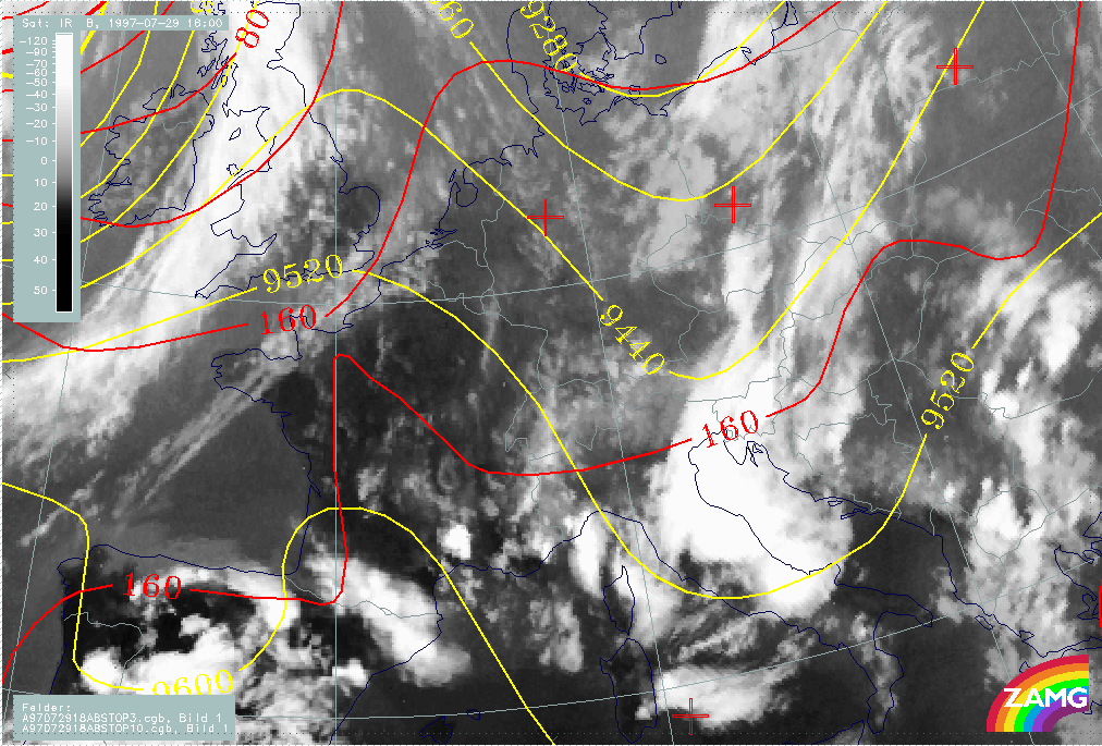
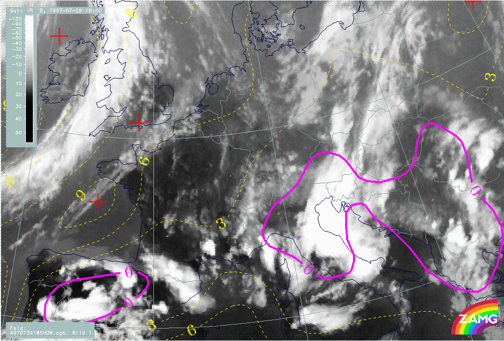
29 July 1997 - Satellite Features And Frontal Diagnosis For 18.00 UTC
|
29 July 1997/18.00 UTC - Meteosat IR image; red: height contours 1000 hPa, yellow: height contours 300 hPa
|
|
|
The image above shows the situation for 18 UTC. At this point of time only one main cloud system can be observed extending from south-east Austria across Slovenia and the Adriatic Sea to Italy, consisting of huge thunderstorm complexes. The development of the MCSs will be shown in a separate chapter. The cloud band with much lower tops and only small convective cells at the eastern boundary over Croatia, Hungary and Slovakia can be evaluated as the remnants of the convergence band.
The surface level still shows an area of very weak gradients but in the upper levels there is a pronounced trough which has approached during the last 12 hours from Germany and has been superimposed on the convergence band originally situated there. This is one reason for the development of the strong thunderstorms.
|
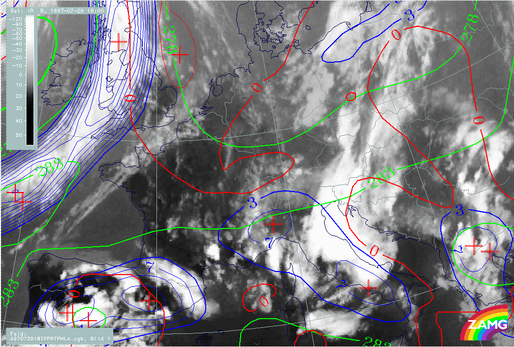
29 July 1997/18.00 UTC - Meteosat IR image; blue: thermal front parameter (TFP) 500/850 hPa, green: equivalent thickness 500/850 hPa,
red: temparature advection - WA 1000 hPa
|
|
|
As can be seen from the image above, there is no notable change in the frontal characteristics; the area under consideration is still an east-west oriented air mass boundary. The new TFP branch over Italy is a consequence of the intensive cloudiness there. As before, well-developed frontal characteristics can be observed only at the cloud band over the Atlantic and England; however the relation to temperature advection has changed there and the biggest part of this cloud band is now under CA.
29 July 1997 - Upper Level Features
|
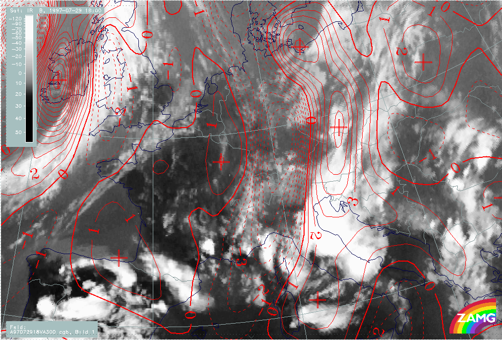
29 July 1997/18.00 UTC - Meteosat IR image; red: vorticity advection 300 hPa
|
|
|
Another reason for the strong thunderstorm development can be found in a zone of strong PVA at 300 hPa accompanying the cloud system. Although the maximum of PVA has moved more to the north there are still high cyclonic values in the area south of the Alps.
|
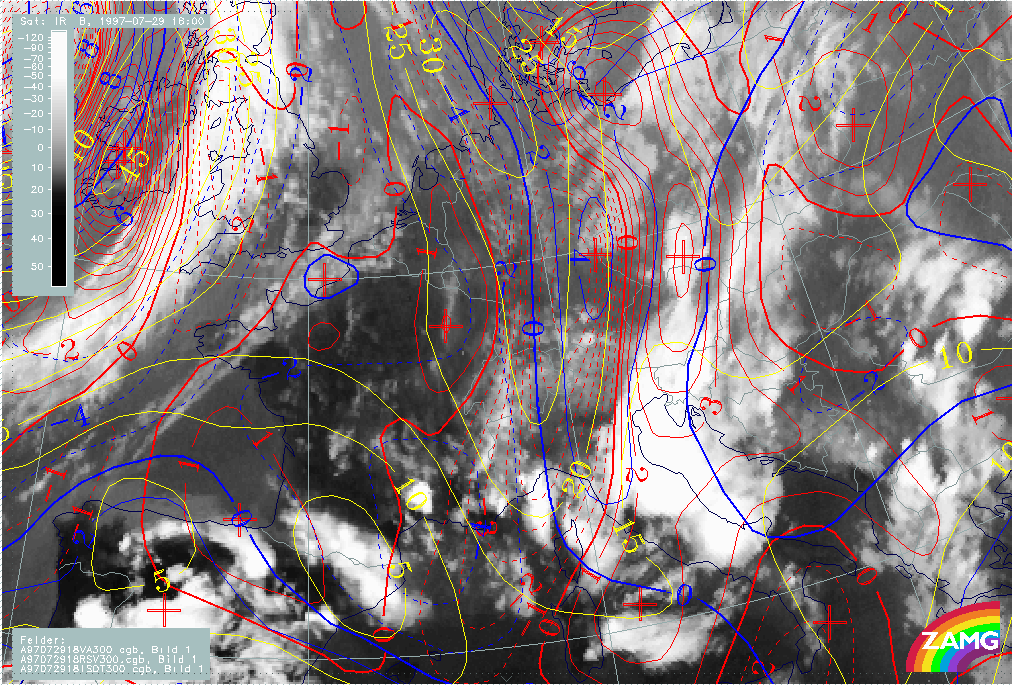
29 July 1997/18.00 UTC - Meteosat IR image; red: vorticity advection 300 hPa, blue: shear vorticity 300 hPa, yellow: isotachs 300 hPa
|
|
|
The image above shows that there is still a jet streak existing which contributes intensified shear vorticity to the PVA maximum. The influence of jet and shear is more dominant in the northern part, which might be the reason for the increased values more to the north. In the southern area, where there is convective cloudiness, the trough with its curvature has more influence.
29 July 1997 - Instability 18.00 UTC
|
29 July 1997/18.00 UTC - Meteosat IR image; yellow: Showalter index 500/850 hPa, magenta: zero line of Showalter index 500/850 hPa
|
|
|
The Showalter index has negative values in the convective area, but the same considerations still apply concerning the discrepancy between the big scale of the area of high thunderstorm probability and the local scale of the real thunderstorm developments.
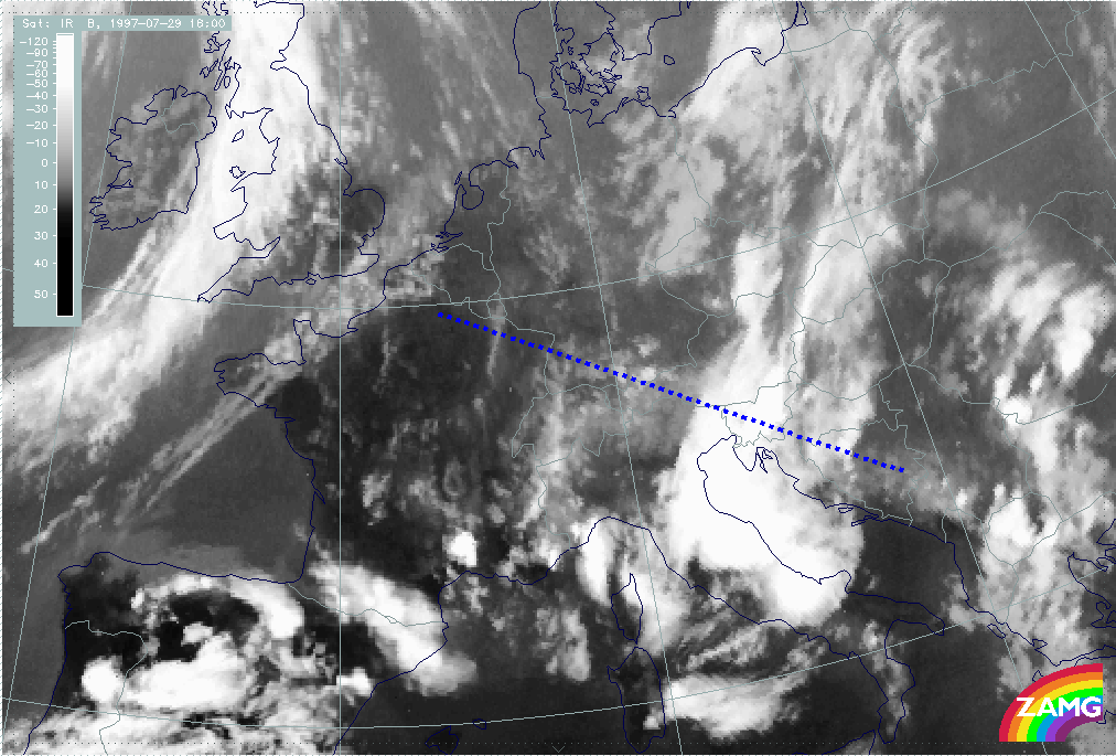
29 July 1997 - Diagnosis For 18.00 UTC With Help Of Vertical Cross Sections
|
29 July 1997/18.00 UTC - Meteosat IR image; position of vertical cross section indicated
|
|
|
|
|
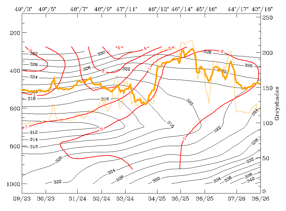
29 July 1997/18.00 UTC - Vertical cross section; black: isentropes (ThetaE), red thin: temperature advection - CA, red thick:
temperature advection - WA, orange thin: IR pixel values, orange thick: WV pixel values
|
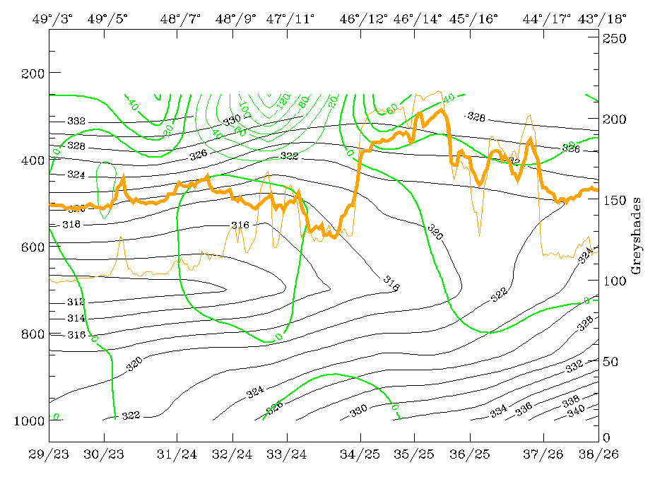
29 July 1997/18.00 UTC - Vertical cross section; black: isentropes (ThetaE), green thick: vorticity advection - PVA, green thin:
vorticity advection - NVA, orange thin: IR pixel values, orange thick: WV pixel values
|
|
|
|
|
|
29 July 1997/18.00 UTC - Vertical cross section; black: isentropes (ThetaE), magenta thin: divergence, magenta thick: convergence,
orange thin: IR pixel values, orange thick: WV pixel values
|
29 July 1997/18.00 UTC - Vertical cross section; cyan thick: vertical motion (omega) - upward motion, cyan thin: vertical motion
(omega) - downward motion, magenta thin: divergence, magenta thick: convergence, orange thin: IR pixel values, orange thick: WV pixel
values pixel values
|
In the vertical cross section for 18.00 UTC there is now only one peak area for IR and WV where the two cloud systems have merged (gridpoints 34/25 - 35/25) (compare Diagnosis for 06.00 UTC with help of vertical cross sections and Diagnosis for 12.00 UTC with help of vertical cross sections ). Distribution of isentropes still shows an intensive unstable air mass from the surface up to at least 600 hPa but the vertical distribution of temperature advection (top left image)is less pronounced now. PVA (top right image) is clearly related to the cloud system now, indicating the approach and mergence of the upper level feature which has taken place during the last 12 hours. Numerous thunderstorms appear in the area of PVA.
The vertical distribution of convergence (bottom left image) and vertical motion (bottom right image), which were very important qualities in the discussion till now, confirm (as does temperature advection) that a change in the state of the troposphere is taking place, although there are still many thunderstorms. Convergence has a more diffuse appearance in the cloud area now and a transition to sinking motion has taken place.
In the following chapter dealing with the thunderstorm developments the breakdown of the convective situation from this time on can be observed.
29 July 1997 - Summary
This case study shows a non-frontal situation where a distinct upper level feature, namely an upper level trough and jet streak producing PVA and cloudiness, crosses a completely different feature of a convergence band with some instability embedded. This mergence leads to a highly unstable troposphere and the development of intensive thunderstorms.
The model was very well able to diagnose and forecast the situation as a whole. But as expected, it was not able to forecast the location of single thunderstorm developments. For this purpose only methods used for nowcasting are appropriate tools at the present time.