Table of Contents
- I. Frontal Diagnosis - 19 February 1997/00.00 UTC
- II. Frontal Diagnosis - 19 February 1997/06.00 UTC
- III. Diagnosis of Rapid Cyclogenesis and Upper Level Trough Feature - 19 February 1997/00.00 UTC
- IV. Diagnosis of Rapid Cyclogenesis and Upper Level Trough Feature - 19 February 1997/06.00 UTC
- V. Very Short Range Forecast
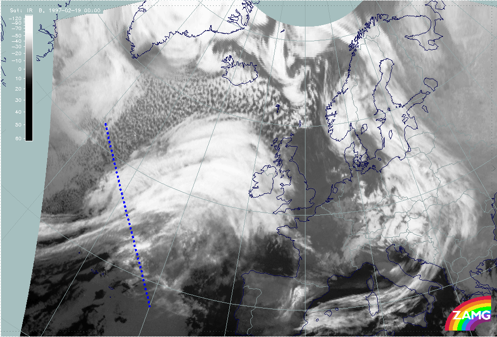
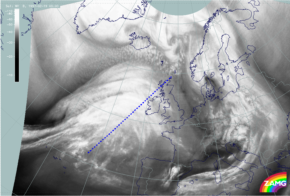
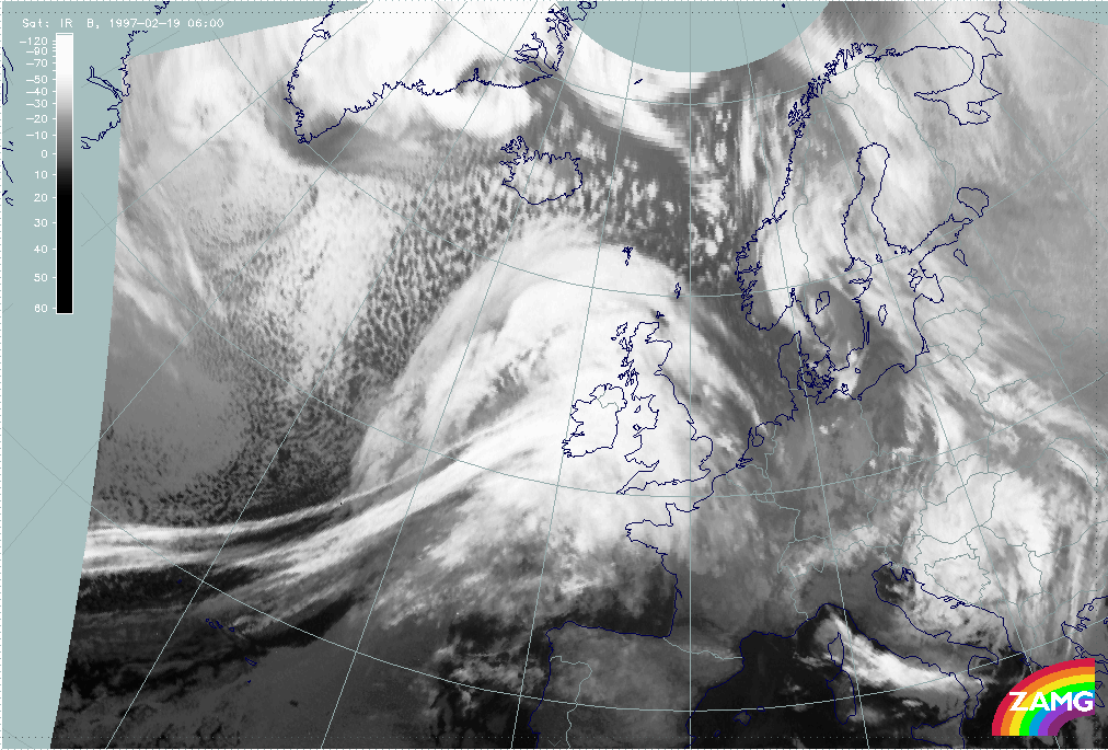
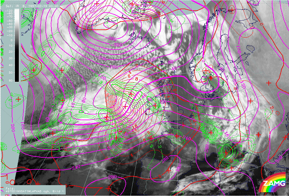
19 February 1997 - Overview Of Satellite Imagery For 00.00 UTC
|
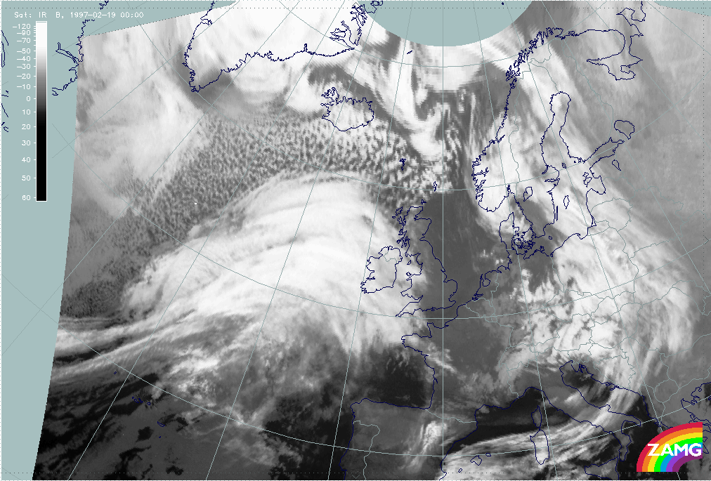
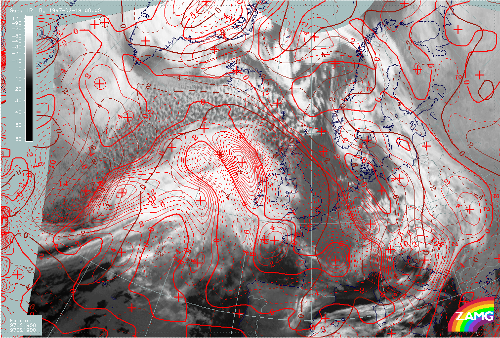
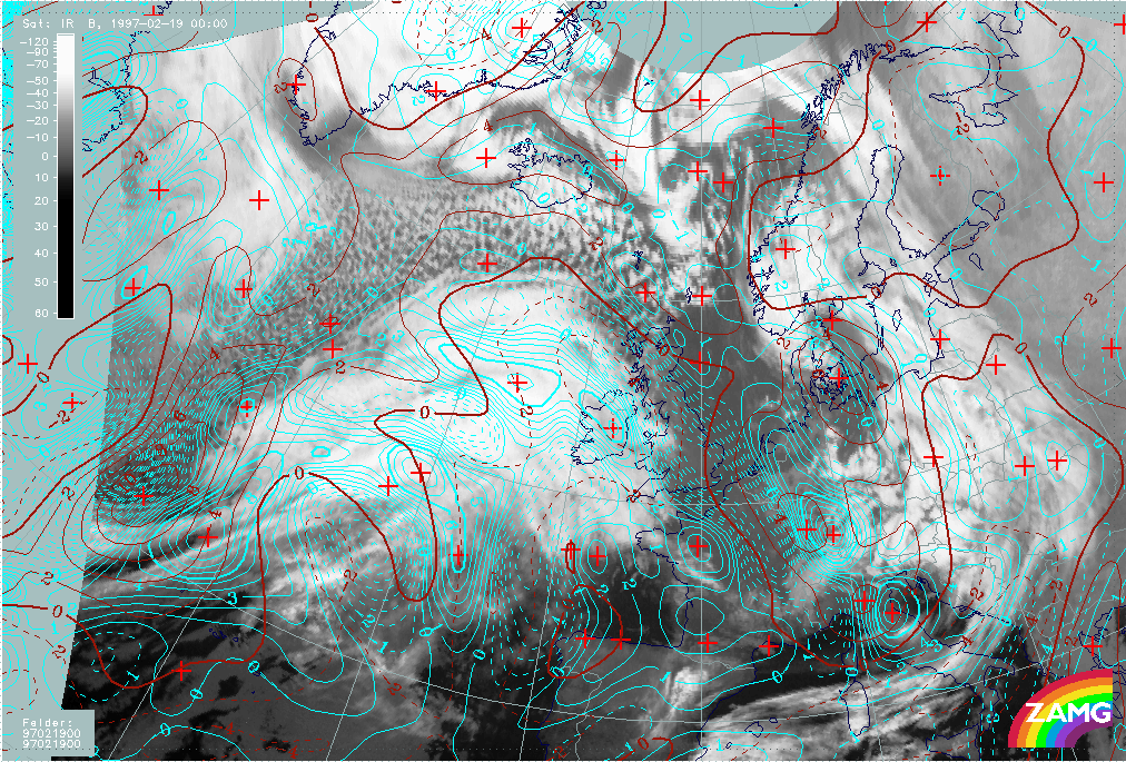
19 February 1997/00.00 UTC - Meteosat IR image
|
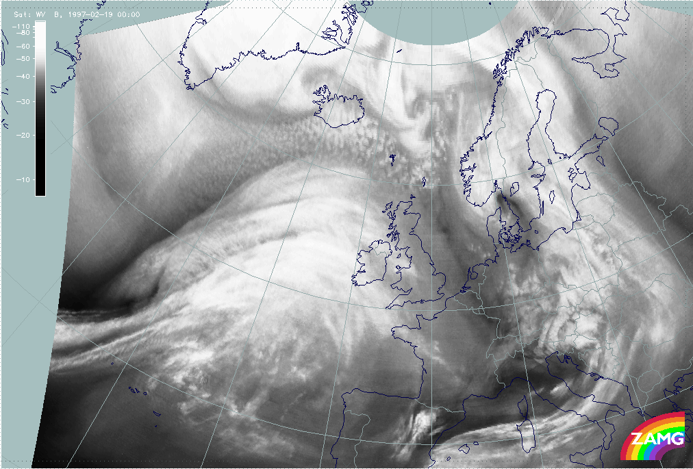
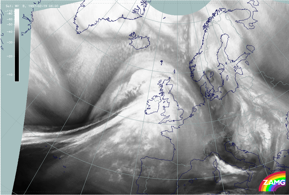
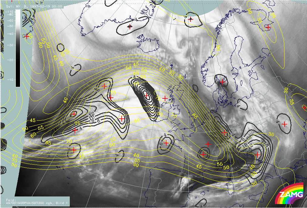
19 February 1997/00.00 UTC - Meteosat WV image
|
|
|
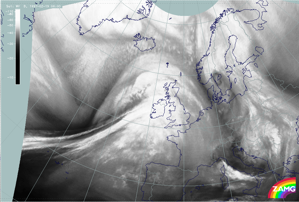
The images above show those cloud systems over the Atlantic which are involved in this case study. There is a pronounced frontal system with a rather small but structured Cold Front cloud band extending from the western edge of the panel (approximately 40N/36W) to the north-east (compare Conceptual Models: Cold Front and Conceptual Models: Cold Front in Cold Advection ) and a huge cloud shield typical for a Warm Front shield extending from the Atlantic (east of 20W) across Ireland and south-west England (compare Conceptual Models: Warm Front Shield ). In the WV image the wet air in the Warm Front Shield and the warm sector is even more impressive, as well as the Dark Stripe at the rear of the Cold Front cloud band representing very dry air. In both images vertical cross section lines are superimposed to indicate for both systems: Cold and Warm Front.
Besides the frontal cloud features an impressive cloud head can be recognized to the north, north-west of the line 44N/30W - 55N/15W. This cloud head suggests a Rapid Cyclogenesis but contains two substructures which deviate from the classical appearance of such a conceptual model. This will be discussed in detail in a separate chapter below (compare Diagnosis of Rapid Cyclogenesis and Upper Level Trough Feature - 19 February 1997/00.00 UTC).
The front diagnosis will be done by a combination of satellite images and relevant parameters on isobaric surfaces (compare Key parameters on isobaric surfaces for 00.00 UTC ) as well as by a combination of satellite signals with other synoptic data in the form of vertical cross sections (compare Use of vertical cross sections for 00.00 UTC ).
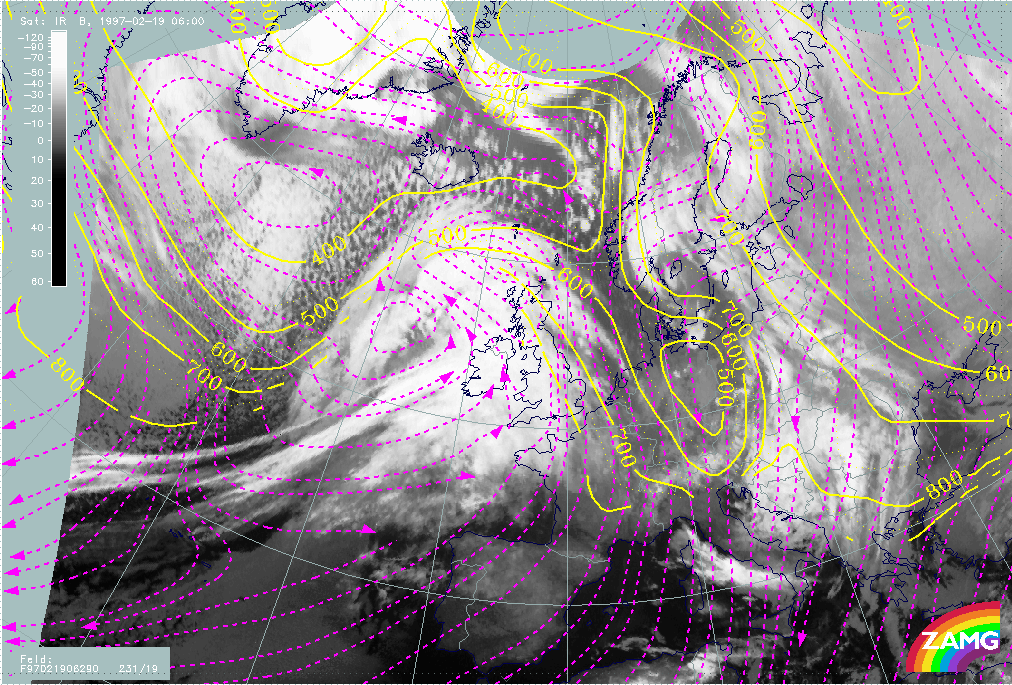
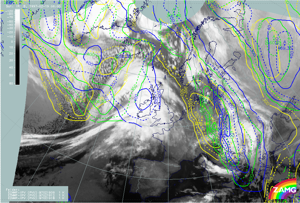
19 February 1997 - Key Parameters On Isobaric Surfaces For 00.00 Utc
|
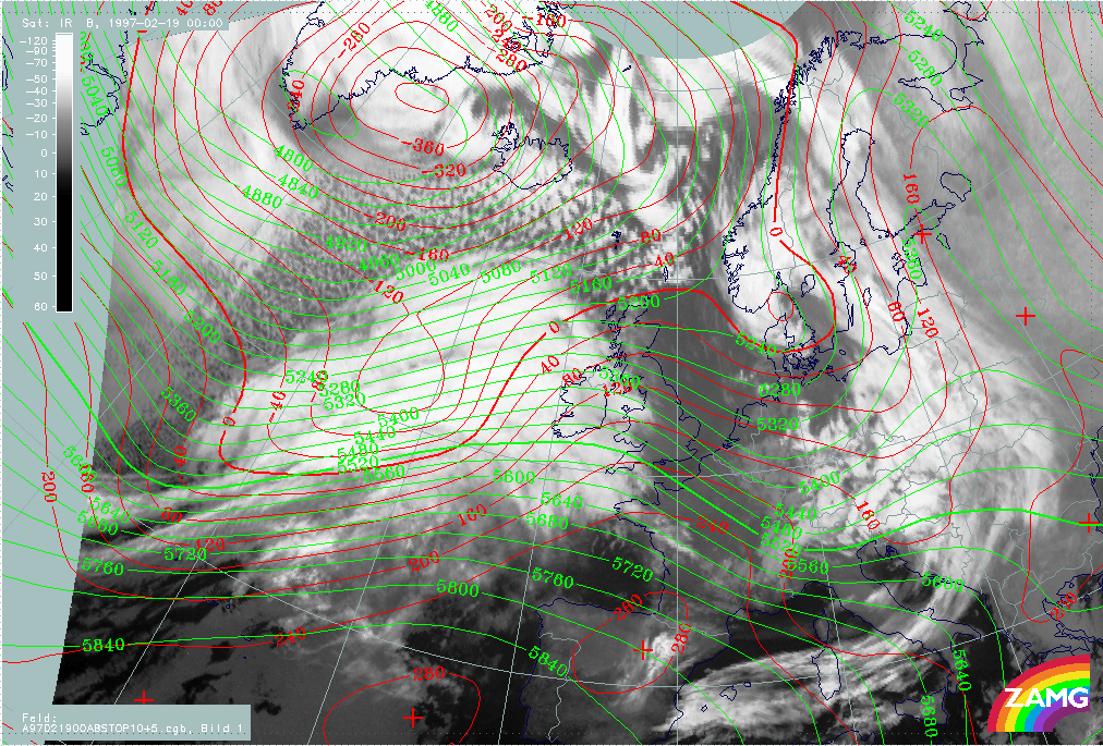
19 February 1997/00.00 UTC - Meteosat IR image; red: height contours 1000 hPa, green: height contours 500 hPa
|
|
|
Surface (1000 hPa) and upper level height (500 hPa) show the most intensive trough features at the rear of the frontal cloud systems but also connected to the cloud head, as for instance a distinct surface low which appears in the centre of the cloud head area. The surface trough extends along the rearward Cold Front edge in south-western directions and an upper level trough line appears at the westernmost rear of the whole cloud system. Trough, west, south-west stream and ridge fit quite well to the Cold and Warm Front cloud configurations.
|
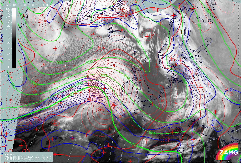
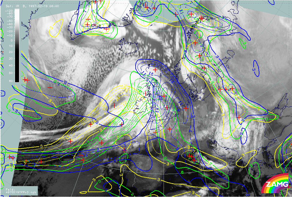
19 February 1997/00.00 UTC - Meteosat IR image; blue: thermal front parameter (TFP) 500/850 hPa, green: equivalent thickness 500/850
hPa, red dashed: temparature advection - CA 1000 hPa, red solid: temparature advection - WA 1000 hPa
|
|
|
The image above combines three key parameters typical for frontal conditions: the equivalent thickness, the thermal front parameter (TFP) and temperature advection (TA). An almost classical situation can be diagnosed with the TFP close to the leading edge of the frontal cloud bands, the zone of high thickness gradients within (for the Warm Front) and partly within (for the Cold Front) the cloud bands, and huge maxima of warm advection (WA) and cold advection (CA) accompanying the Warm and Cold Front respectively.
Such a distribution is indicative of an Ana Front type of Cold Front, a fact which can best be checked with help of vertical cross sections (compare Use of vertical cross sections for 00.00 UTC ).
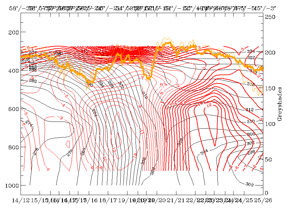
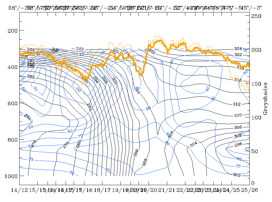
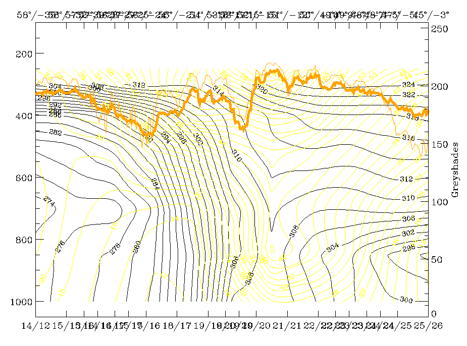
19 February 1997 - Use Of Vertical Cross Sections For 00.00 UTC
|
19 February 1997/00.00 UTC - Meteosat IR image; position of vertical cross section indicated
|
|
|
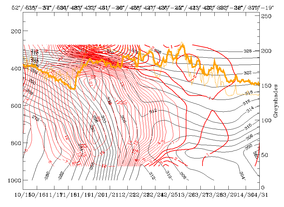
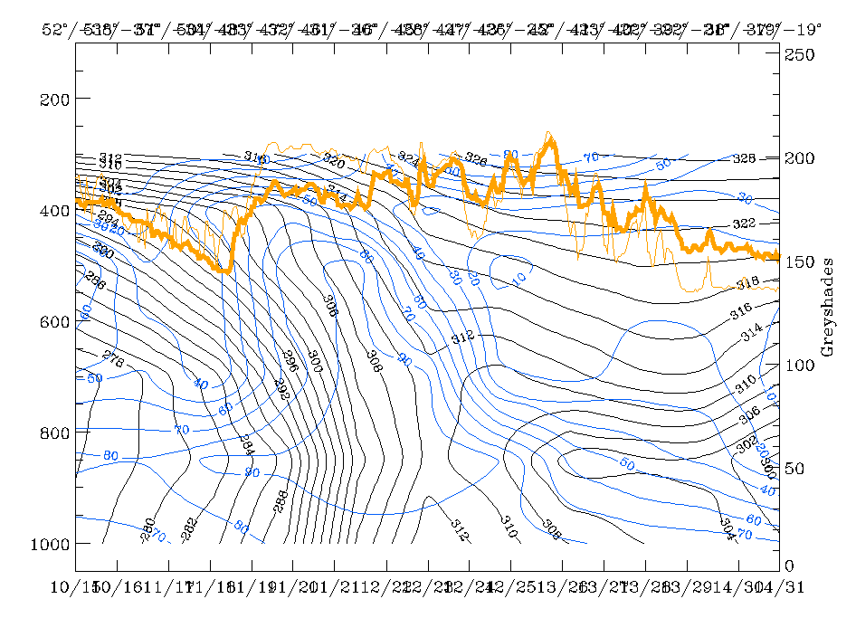
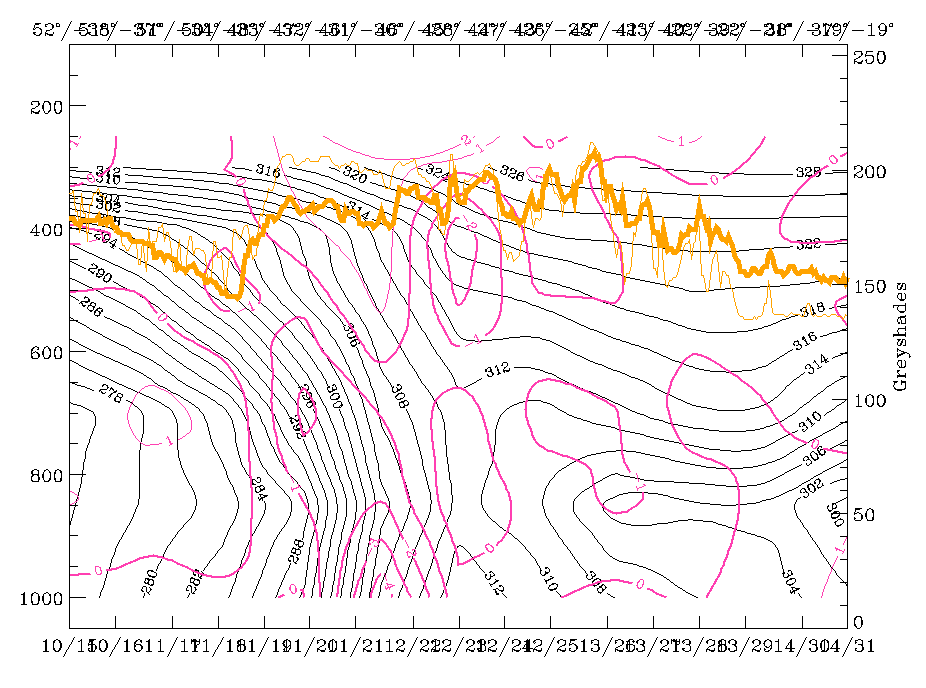
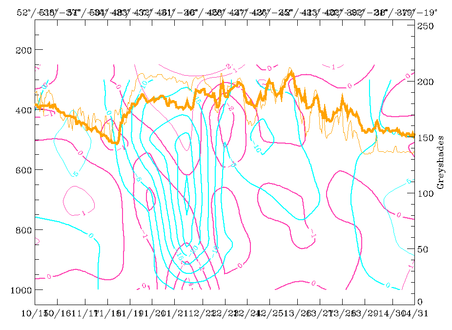
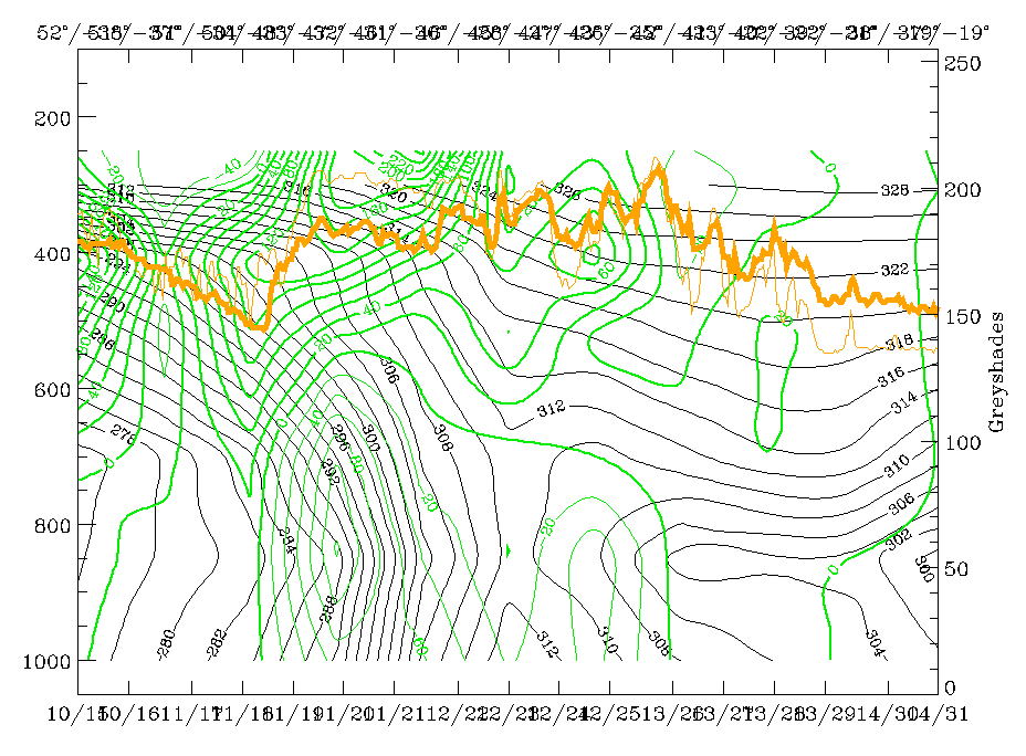
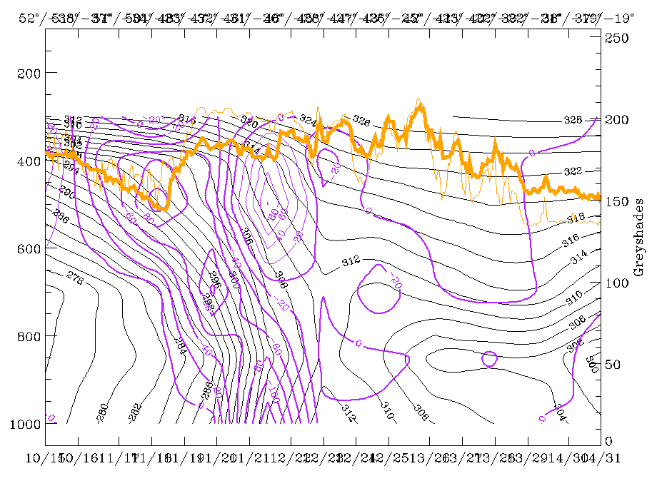
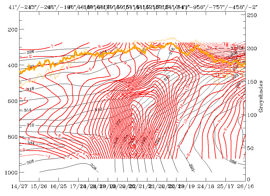
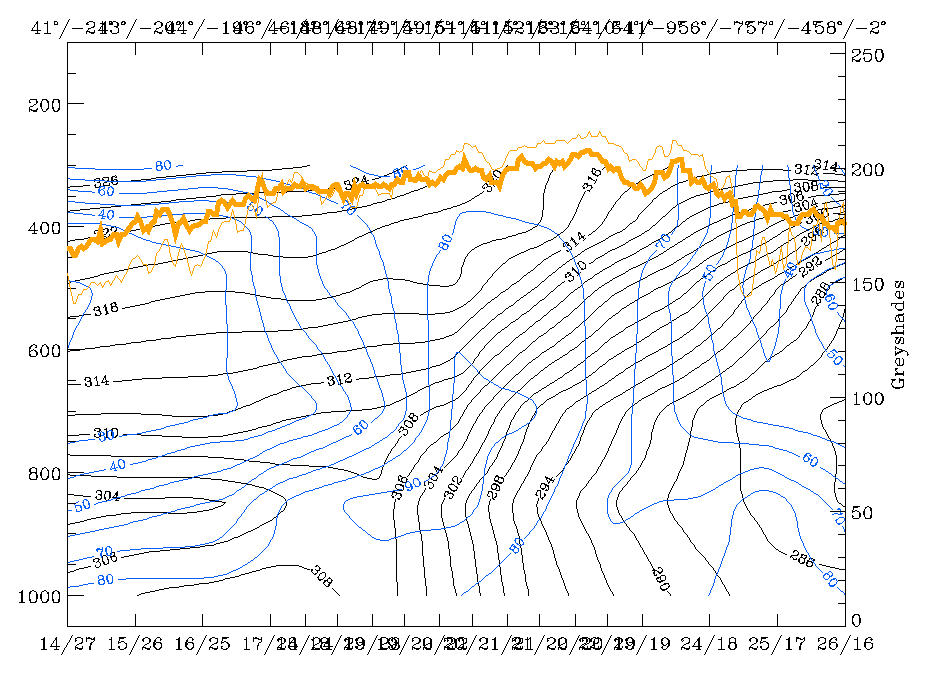
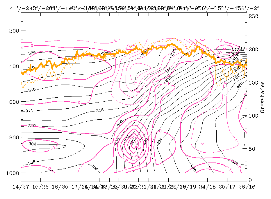
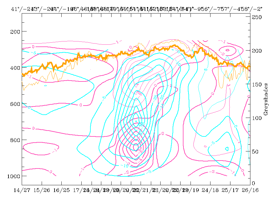
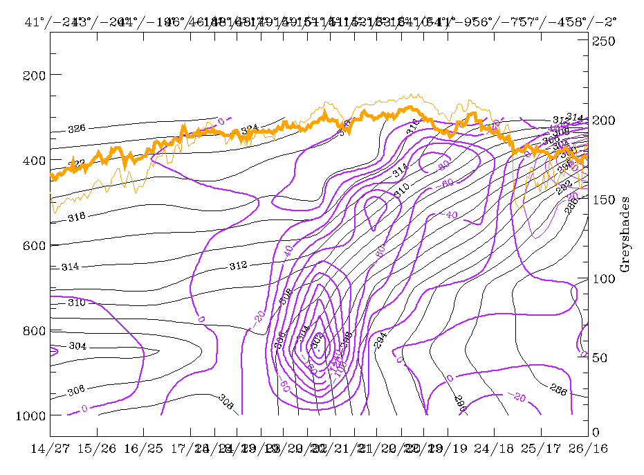
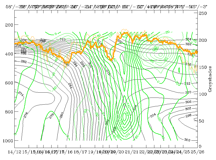
The cross section line indicative for the cold front is superimposed on the IR image. The block of parameters below reproduces the state of a well developed Cold Front of the Ana type.
|
19 February 1997/00.00 UTC - Vertical cross section; black: isentropes (ThetaE), red thin: temperature advection - CA, red thick:
temperature advection - WA, orange thin: IR pixel values, orange thick: WV pixel values
|
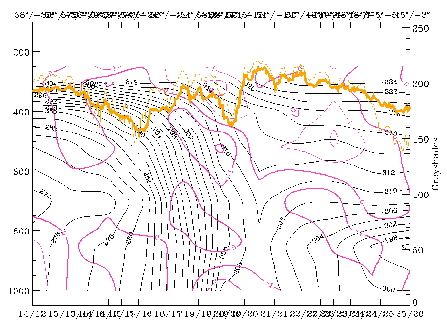
19 February 1997/00.00 UTC - Vertical cross section; black: isentropes (ThetaE), blue: relative humidity, orange thin: IR pixel values,
orange thick: WV pixel values
|
|
|
|
|
|
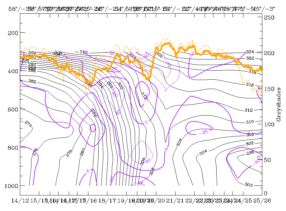
19 February 1997/00.00 UTC - Vertical cross section; black: isentropes (ThetaE), magenta thin: divergence, magenta thick: convergence,
orange thin: IR pixel values, orange thick: WV pixel values
|
19 February 1997/00.00 UTC - Vertical cross section; cyan thick: vertical motion (omega) - upward motion, cyan thin: vertical motion
(omega) - downward motion, magenta thin: divergence, magenta thick: convergence, orange thin: IR pixel values, orange thick: WV pixel
values pixel values
|
There is a zone of high gradients of isentropes steeply inclined downward from approximately 400 - 500 hPa behind the cloud systems to the surface at approximately 46N/30W showing some double structure in the upper levels; a zone of high humidity accompanied by high pixel values is bent backward (right image top). Temperature advection (left image top) clearly shows that there is CA already in front of the frontal zone, which is quite common for Ana Cold Fronts. The left and right images at the bottom contain a well-developed frontal circulation cell consisting of a convergence zone accompanying the high gradients of the isentropic frontal surface, a divergence zone immediately above this frontal surface and intensive upward motion on top of the convergence and frontal zones.
|
19 February 1997/00.00 UTC - Vertical cross section; black: isentropes (ThetaE), green thick: vorticity advection - PVA, green thin:
vorticity advection - NVA, orange thin: IR pixel values, orange thick: WV pixel values
|
19 February 1997/00.00 UTC - Vertical cross section; black: isentropes (ThetaE), lilac: Q-Vector (normal component), orange thin: IR
pixel values, orange thick: WV pixel values
|
|
|
Also positive vorticity advection (PVA) plays an important role in the area of the frontal surface (left image). High values of PVA in upper levels showing increase of PVA with height accompany the whole frontal surface. Finally a frontogenetic parameter (the normal component of the Q-vector) supports this impression of a well-developed strong cold front by a zone of isolines indicating frontogenesis (right image).
|
19 February 1997/00.00 UTC - Meteosat WV image; position of vertical cross section indicated
|
|
|
The vertical cross section line representing the Warm Front is superimposed on the WV image.
|
19 February 1997/00.00 UTC - Vertical cross section; black: isentropes (ThetaE), red thin: temperature advection - CA, red thick:
temperature advection - WA, orange thin: IR pixel values, orange thick: WV pixel values
|
19 February 1997/00.00 UTC - Vertical cross section; black: isentropes (ThetaE), blue: relative humidity, orange thin: IR pixel values,
orange thick: WV pixel values
|
|
|
|
|
|
19 February 1997/00.00 UTC - Vertical cross section; black: isentropes (ThetaE), magenta thin: divergence, magenta thick: convergence,
orange thin: IR pixel values, orange thick: WV pixel values
|
19 February 1997/00.00 UTC - Vertical cross section; cyan thick: vertical motion (omega) - upward motion, cyan thin: vertical motion
(omega) - downward motion, magenta thin: divergence, magenta thick: convergence, orange thin: IR pixel values, orange thick: WV pixel
values
|
Also the Warm Front shows a very distinct appearance and structure in the vertical cross section. There is a distinct broad zone of high gradients of isentropes with a Warm Front inclination and a distinct surface front; humidity (right image top) consists of high values within and on top of the frontal zone, and low values below it. There is very pronounced WA (left image top) and (as for the Cold Front) a well-developed frontal circulation cell (left and right image bottom) with convergence within the high gradient of the frontal surface, and intensive upward motion as well as divergence on top of it.
|
19 February 1997/00.00 UTC - Vertical cross section; black: isentropes (ThetaE), lilac: Q-Vector (normal component), orange thin: IR
pixel values, orange thick: WV pixel values
|
|
|
From the normal component of the Q-vector (right image top) frontogenesis can be supposed especially within the lower layers of the frontal surface.
Summarizing these diagnoses one can say that both Cold Front and Warm Front represent well-developed conceptual models (compare Conceptual Models: Cold Front and Conceptual Models: Warm Front Shield ) with rather classical distributions of the relevant key parameters. The next sub-chapter deals with the frontal situation six hours later (compare Frontal Diagnosis - 19 February 1997/06.00 UTC).
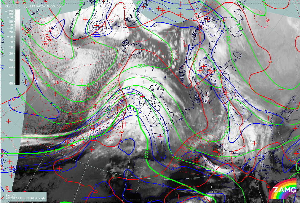
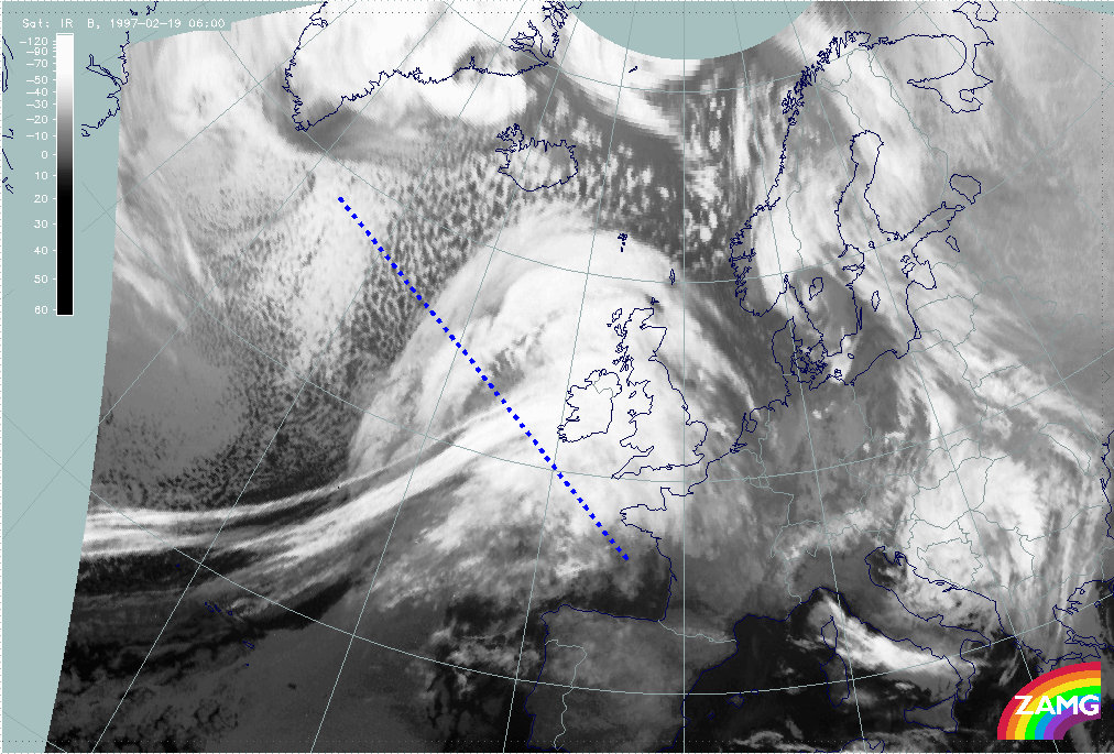
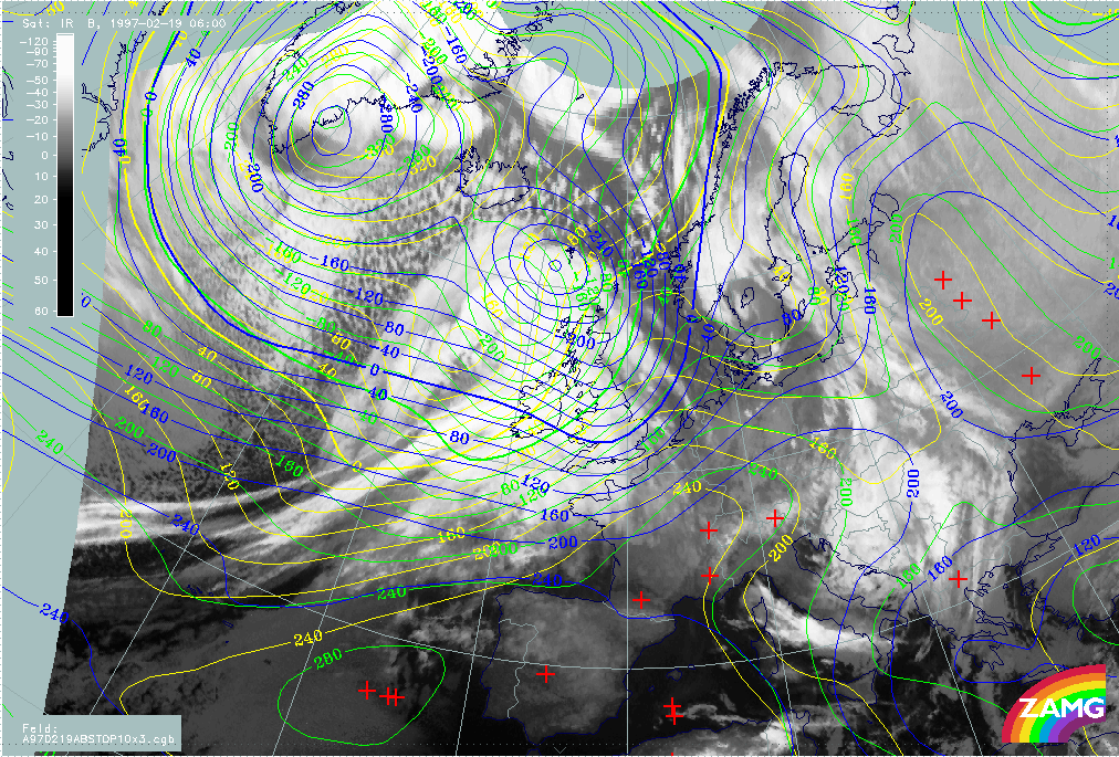
19 February 1997 - Overview Of Satellite Imagery For 06.00 UTC
|
19 February 1997/06.00 UTC - Meteosat IR image
|
19 February 1997/06.00 UTC - Meteosat WV image
|
|
|
The Cold Front cloud band and the Warm Front cloud shield are still easily recognizable (left image). The cold front is accompanied by some narrow fibres which are typical for the jet axis. The whole cloud system has moved eastward with the cloud shield of the Warm Front now being superimposed on the British Isles. As before, the structures in the WV image (right image) are even more distinct with a broad humid shield in the area of the Warm Front and a characteristic Black Stripe at the rear of the Cold Front band.
This black stripe separates the frontal cloud features from the cloud head to the north very distinctly. In contrast to the frontal features which have maintained their appearance during the last six hours, the cloud head has undergone many more changes. This will be discussed later in a separate chapter about Rapid Cyclogenesis and upper level features (compare Diagnosis of Rapid Cyclogenesis and Upper Level Trough Feature - 19 February 1997/00.00 UTC and Diagnosis of Rapid Cyclogenesis and Upper Level Trough Feature - 19 February 1997/06.00 UTC).
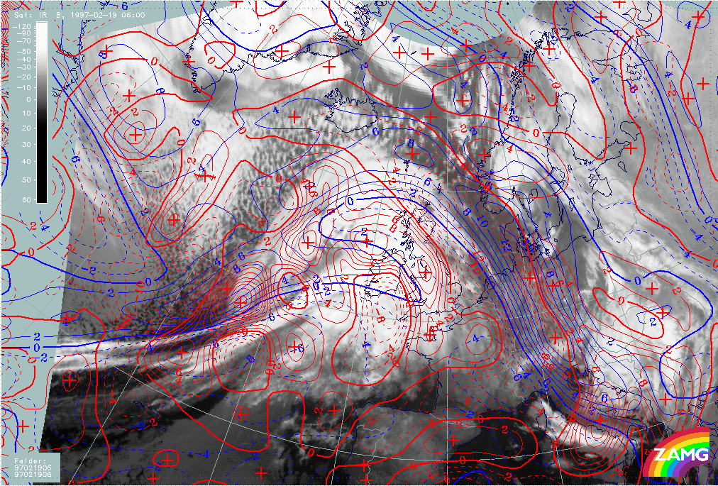
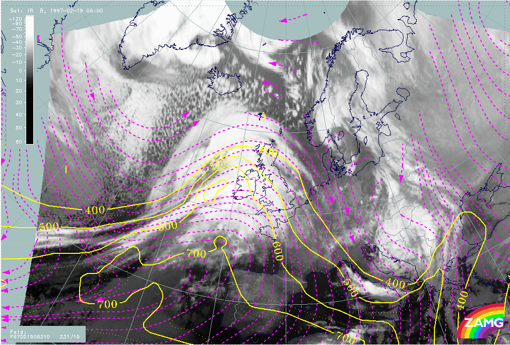
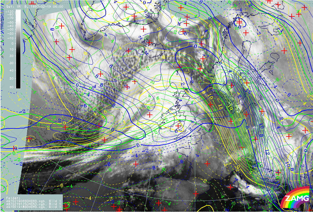
19 February 1997 - Key Parameters On Isobaric Surfaces For 06.00 UTC
|
19 February 1997/06.00 UTC - Meteosat IR image; blue: thermal front parameter (TFP) 500/850 hPa, green: equivalent thickness 500/850
hPa, red: temparature advection - WA 1000 hPa
|
19 February 1997/06.00 UTC - Meteosat IR image; blue: thermal front parameter (TFP) 500/850 hPa, green: equivalent thickness 500/850
hPa, red: temparature advection - CA 1000 hPa
|
|
|
The typical key parameters on isobaric surfaces: equivalent thickness, TFP and temperature advection (TA) are still very well-developed. The TFP is situated at the leading edge of the Cold Front cloud band and within the shield of the Warm Front; a zone of high thickness gradients accompanying the cloud bands is especially distinct in the warm front area. The amplitude of the thickness wave has increased, resulting in a pronounced ridge in the Warm Front and warm sector area, and a pronounced trough in the cold air area behind. Still very pronounced also is the WA maximum which covers the whole Warm Front Shield and a part of the cloud head (left image); intensive CA is connected with the Cold Front (right image).
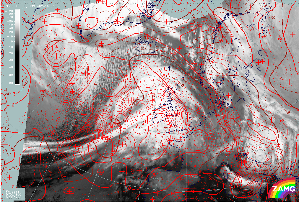
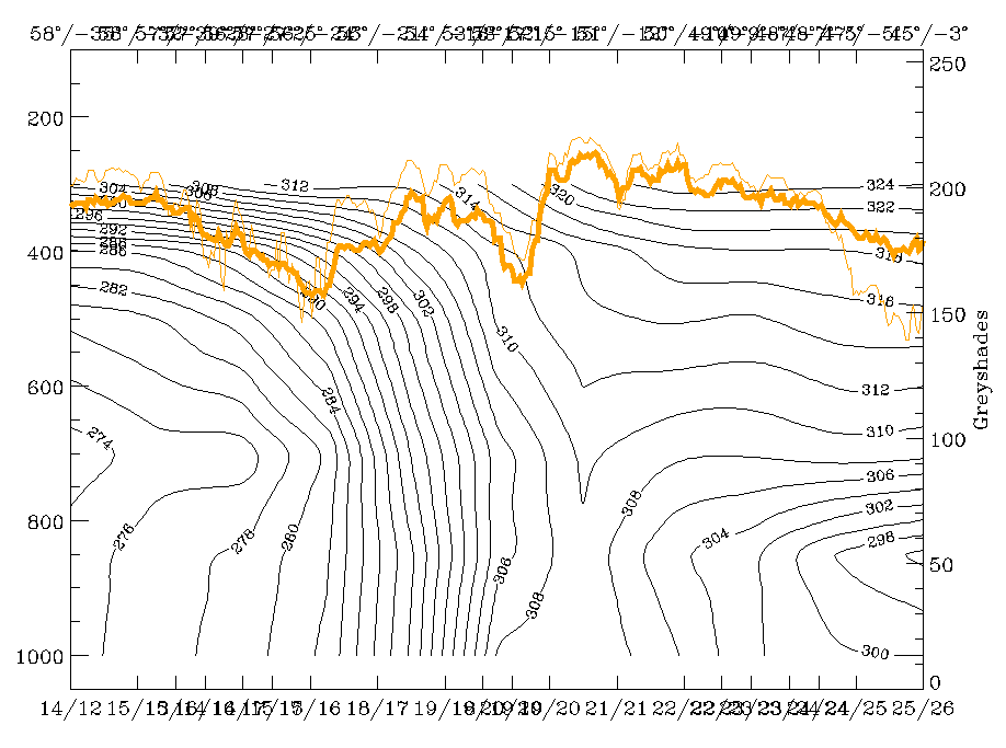
19 February 1997 - Use Of Vertical Cross Sections For 06.00 UTC
|
19 February 1997/06.00 UTC - Meteosat IR image; position of vertical cross section indicated
|
|

|
As the systems are really good examples for classical frontal systems another vertical cross section will be investigated for the Cold Front. The vertical cross section line is superimposed on the IR image above; the relevant cross sections can be found in the images below.
|
19 February 1997/06.00 UTC - Vertical cross section; black: isentropes (ThetaE), red thin: temperature advection - CA, red thick:
temperature advection - WA, orange thin: IR pixel values, orange thick: WV pixel values
|
19 February 1997/06.00 UTC - Vertical cross section; black: isentropes (ThetaE), blue: relative humidity, orange thin: IR pixel values,
orange thick: WV pixel values
|
|
|
|
|
|
19 February 1997/06.00 UTC - Vertical cross section; black: isentropes (ThetaE), yellow: isotachs, orange thin: IR pixel values, orange
thick: WV pixel values
|
19 February 1997/06.00 UTC - Vertical cross section; black: isentropes (ThetaE), green thick: vorticity advection - PVA, green thin:
vorticity advection - NVA, orange thin: IR pixel values, orange thick: WV pixel values
|
There is still a very steep downward inclined frontal zone in the isentropes with a distinct surface front at 52N/12W which is between the Cold Front band and the cloud head (left and right image top).
The IR signals show two peaks:
- The one within the frontal zone at the rear of the surface front represents the cloud head;
- The other, even higher one in front of the frontal and surface front represents the Cold Front cloudiness.
Consequently in this area of the Cold Front no Ana Front character can be noticed any longer. Temperature advection (left image top) still shows intensive CA already in front of the Cold Front but reveals also the possibility of a secondary upper level Cold Front, a fact which is also supported by the inclination of the isentropes there. This could indicate that the higher cloudiness of the Cold Front is bound to an upper level front while a distinct frontal surface, together with a pronounced surface front, develops with the cloud head to the north.
|
19 February 1997/06.00 UTC - Vertical cross section; black: isentropes (ThetaE), magenta thin: divergence, magenta thick: convergence,
orange thin: IR pixel values, orange thick: WV pixel values
|
19 February 1997/06.00 UTC - Vertical cross section; black: isentropes (ThetaE), lilac: Q-Vector (normal component), orange thin: IR
pixel values, orange thick: WV pixel values
|
|
|
Convergence and frontogenesis shown in images (left and right image) are much weaker now.
19 February 1997 - Overview Of Satellite Image For Rapid Cyclogenesis 00.00 UTC
|
19 February 1997/00.00 UTC - Meteosat IR image
|
19 February 1997/00.00 UTC - Meteosat WV image
|

|

|
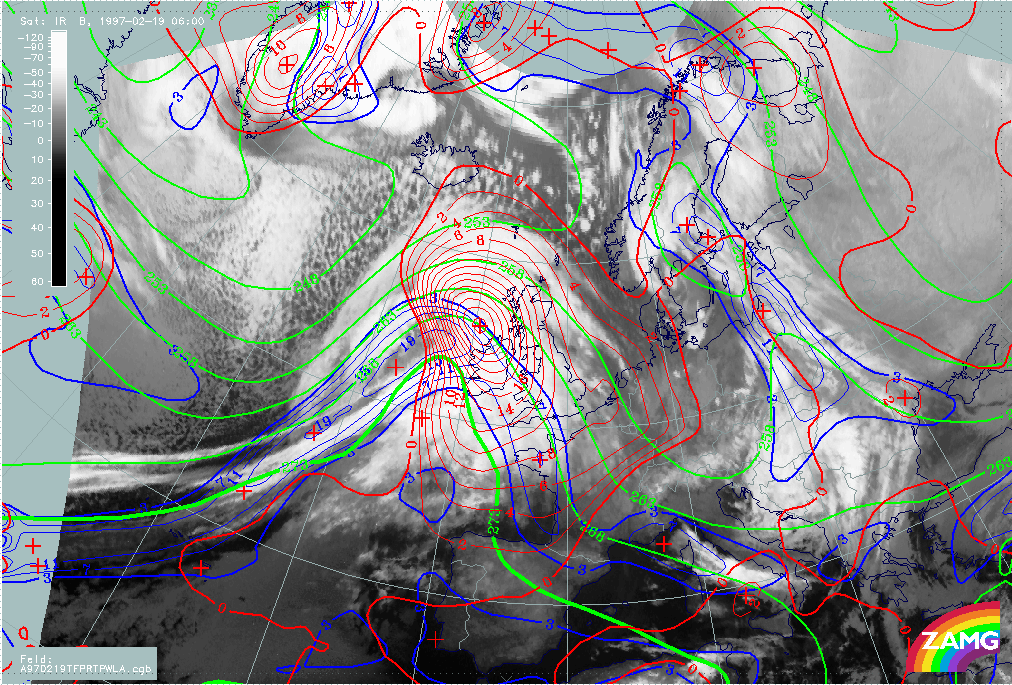
Already during the frontal diagnosis the cloud configurations to the north-north-west of the frontal cloud band (north-north-west of the line 44N/30W - 55N/15W) have been mentioned and called cloud head. This expression indicates already the first guess about the existence of the conceptual model of a Rapid Cyclogenesis (compare Conceptual Models: Rapid Cyclogenesis ). However, cloudiness deviates in many instances from the typical configurations described for a Rapid Cyclogenesis. The images above show a cloud system which is clearly separated from the frontal cloudiness and has over a wide area lower cloud tops; thus it can be interpreted as the typical cloud shield which protrudes from below the frontal cloudiness. But in this case the cloud head area is by far too extended and shows two separate cloud bulges. It is not clear from the imagery which of the two bulges (if any) belongs to a Rapid Cyclogenesis. This uncertainty is increased by an even more distinct double structure in the WV imagery (right image).
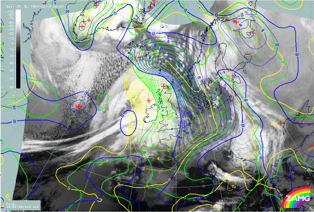
19 February 1997 - Key Parameters On Isobaric Surfaces For Rapid Cyclogenesis 00.00 UTC
As satellite imagery cannot support and localise a conceptual model Rapid Cyclogenesis alone, the other relevant key parameters of the conceptual model have to be inspected: numerical parameters on isobaric surfaces. Three parameter combinations are relevant for such a physical situation:
- The typical Wave parameters like surface low, WA maximum and PVA maximum at 500 hPa: in the case of Rapid Cyclogenesis all parameters indicating a Wave development should also be well developed;
- The jet situation at 300 hPa: in the case of Rapid Cyclogenesis, a jet streak with sinking dry air at the cyclonic side and a PVA maximum in the left exit region over the cloud head area can be expected;
- The vertical distribution of potential vorticity (PV) shows very dry, sometimes even stratospheric air, down to heights of 400 - 500 hPa; the most convenient key parameter for this is the height of PV = 2 units a threshold which is regarded as the transition from tropospheric to stratospheric air.
|
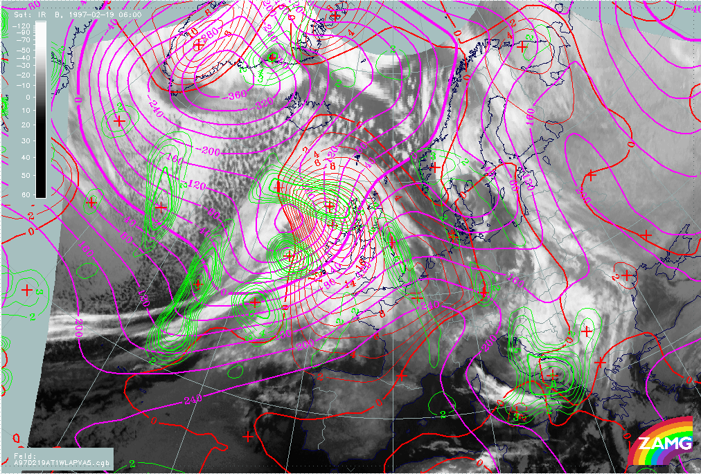
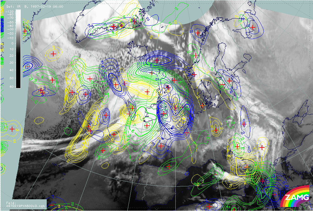
19 February 1997/00.00 UTC - Meteosat IR image; magenta: height contours 1000 hPa, green: positive vorticity advection (PVA) 500 hPa,
red: temparature advection - WA 1000 hPa
|
|
|
The image above includes the group of wave parameters. A pronounced surface low (1000 hPa) as well as a WA maximum accompany the north-eastern of the two cloud bulges and thus support a Wave development there. In contrast, the PVA maximum at 500 hPa belonging to this area is rather weak and its relation to the Wave is somewhat unclear. There is a second much better developed PVA maximum at the rear of the south-western cloud bulge. This latter cloud structure has some features of a Comma but is connected with the frontal cloudiness instead of being separated within the cold air. So up to now this case shows several similarities with the conceptual models Wave (compare Conceptual Models: Wave ), Rapid Cyclogenesis (compare Conceptual Models: Rapid Cyclogenesis ) and Comma (compare Conceptual Models: Comma ) in this region.
|
19 February 1997/00.00 UTC - Meteosat IR image; green: positive vorticity advection (PVA) 300 hPa, yellow: isotachs 300 hPa
|
|
|
The image above adds the jet streak information which at first glance unfortunately complicates the situation instead of resolving it. There are three jet streaks:
- An intensive one at the leading edge of the Warm Front cloud shield over the British Isles; it is not involved in the Rapid Cyclogenesis process;
- A smaller one in the area of the north-eastern cloud bulge which is not clearly related to the cloudiness but might be responsible for the substructure in the WV imagery;
- A distinct one at the rearward edge of the Cold Front immediately south of the Comma - like feature; this jet streak might be connected with the Rapid Cyclogenesis, too.
The PVA maxima do not have any distinct connection to a left exit region of any of these jet streaks. Therefore a more detailed analysis of these PVA maxima has to be done. Such a situation appears from time to time and one tool for getting a better overview of the synoptic situation is the separate use of shear and curvature vorticity.
Hints for difficult PVA field interpretation
|
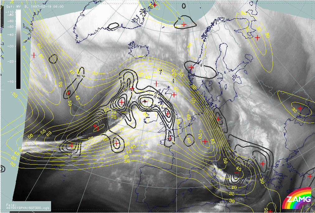
19 February 1997/00.00 UTC - Meteosat IR image; red: vorticity advection 300 hPa, brown: curvature vorticity 300 hPa
|
|
|
The image above shows the PVA field at 300 hPa together with curvature vorticity at this level. With this combination the two north-south oriented PVA lobes parallel to the Warm Front and within the warm sector can be sorted out. They exist in wide areas of anticyclonic vorticity and represent regions where it becomes less anticyclonic. Up to now no distinct synoptic meaning and reflectance is known with those situations. The most pronounced cyclonic phenomenon is the curvature maximum at the rear of the south-western cloud bulge. This fits nicely to the conceptual models of upper level features like Commas with a maximum of curvature vorticity causing a spiral structure and a PVA maximum which is maintaining and/or intensifying cloudiness.
|
19 February 1997/00.00 UTC - Meteosat IR image; red: vorticity advection 300 hPa, blue: shear vorticity 300 hPa
|
|
|
The image shows the connection between PVA and shear vorticity at 300 hPa. There are two maxima of shear vorticity close to the rearward edges of the two cloud bulges. The northern one does not seem to have a distinct connection to the Rapid Cyclogenesis which is supposed to be connected with the north-eastern cloud bulge; the south-western shear vorticity maximum is very close to the curvature maximum there (compare the first image on this page) but has a much bigger south-west - north-east orientation. Consequently the north-easternmost part of the relevant PVA lobe seems to best correspond to the area of Rapid Cyclogenesis.
|
19 February 1997/00.00 UTC - Meteosat IR image; red: vorticity advection 500 hPa, blue: shear vorticity 500 hPa
|
19 February 1997/00.00 UTC - Meteosat IR image; red: vorticity advection 500 hPa, brown: curvature vorticity 500 hPa
|
|
|
The images above leave the jet level and show shear and curvature vorticity at 500 hPa. The results are the same as for 300 hPa but are even more distinct.
Summarizing the outcome of satellite images and numerical model parameters, till now a conceptual model Rapid Cyclogenesis in the north-eastern cloud bulge and a conceptual model Comma (-like) in the south-western cloud bulge can be supported. Shear and curvature vorticity (although close together) show different orientation and therefore the PVA maxima related to them influence the different cloud areas.
19 February 1997 - Overview Of Satellite Image For Rapid Cyclogenesis 06.00 UTC
|
19 February 1997/06.00 UTC - Meteosat IR image
|
19 February 1997/06.00 UTC - Meteosat WV image
|

|
|
The images already discussed in the chapter on frontal diagnosis (compare Overview of satellite imagery for 06.00 UTC ) shows several changes in the area of the cloud bulges north-north-west of the frontal cloud bands. With satellite imagery alone and without knowledge of the genesis, a Rapid Cyclogenesis can still be supposed but its location is still not quite clear. Relaying on the information already derived for 00.00 UTC and on the Black Stripe in the WV image of 06.00 UTC, a Rapid Cyclogenesis can be presumed more in the centre of the huge cloud shield as well as a Comma feature in the south-western part of it.
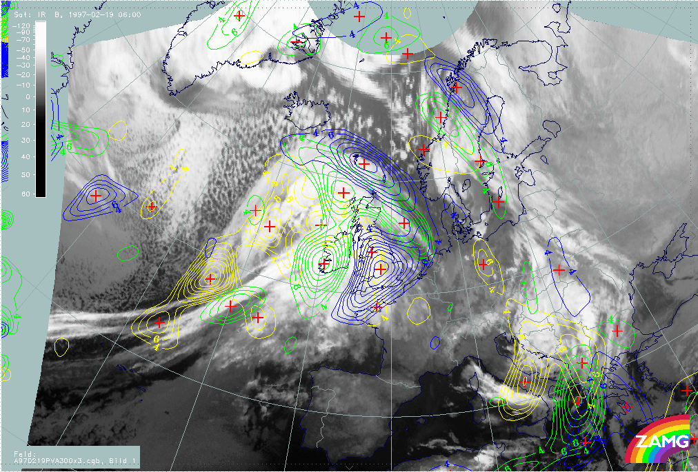
19 February 1997 - Key Parameters On Isobaric Surfaces For Rapid Cyclogenesis 06.00 UTC
|
19 February 1997/06.00 UTC - Meteosat IR image; magenta: height contours 1000 hPa, green: positive vorticity advection (PVA) 500 hPa,
red: temparature advection - WA 1000 hPa
|
19 February 1997/06.00 UTC - Meteosat IR image; black: positive vorticity advection (PVA) 300 hPa, yellow: isotachs 300 hPa
|
|
|
The same relevant parameter combinations as before are presented in the left and right images above (compare Key parameters on isobaric surfaces for Rapid Cyclogenesis 00.00 UTC ). The deepening of the surface low is very distinct as well as the WA maximum; both give hints for the localisation of the Rapid Cyclogenesis. For a better relation between cloudiness and PVA maxima, clarification is expected from curvature and shear vorticity.
The jet streak diagnosis in the right image is much easier now using the knowledge gained before. The dominant jet streak is at the rear side of the Cold Front with a south-west - north-east orientation, and the PVA maximum in its left exit region corresponds to the intensified cloud patches. However there is a second jet streak north of Scotland close to a substructure in the cloud shield there. It is common experience that such secondary jet streaks may develop in connection with a Rapid Cyclogenesis.
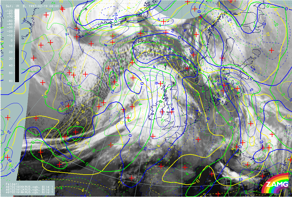
Hints for difficult PVA field interpretation
|
19 February 1997/06.00 UTC - Meteosat IR image; red: vorticity advection 300 hPa, blue: shear vorticity 300 hPa
|
19 February 1997/06.00 UTC - Meteosat IR image; red: vorticity advection 300 hPa, brown: curvature vorticity 300 hPa
|
|
|
The images above differentiate between shear and curvature vorticity at 300 hPa. The comparison still shows that both vorticity maxima are close together but have a different orientation, hence the PVA maximum related to the curvature maximum influences the Comma feature, while the PVA maximum related to the shear maximum appears together with the Rapid Cyclogenesis.
Summarizing, this case study showed that it was possible to detect and separate two conceptual models - a Rapid Cyclogenesis development and a comma-like cold air feature - by means of a synopsis of all key parameters relevant for the conceptual models mentioned.
One set of key parameters which has not yet been mentioned are relative streams on isentropic surfaces (compare Relative streams and conveyor belts for Rapid Cyclogenesis 06.00 UTC ).
19 February 1997 - Relative Streams And Conveyor Belts For Rapid Cyclogenesis 06.00 UTC
|
19 February 1997/06.00 UTC - Meteosat IR image; position of vertical cross section indicated
|
19 February 1997/06.00 UTC - Vertical cross section; black: isentropes (ThetaE), orange thin: IR pixel values, orange thick: WV pixel
values
|
|
|
The right image shows again the vertical cross section which is perpendicular to the cloud shield of the Rapid Cyclogenesis and to the Cold Front band (compare left image). In the ideal case there are typical relative streams connected with a Rapid Cyclogenesis, with a different appearance on low and high isentropic surfaces. In this case the 290K surface represents a low surface close to the bottom of the frontal zone, while 310K is a high surface on the top of the frontal zone.
|
19 February 1997/06.00 UTC - Meteosat IR image; magenta: relative streams 290K - system velocity 231° 19 m/s, yellow: isobars
|
19 February 1997/06.00 UTC - Meteosat IR image; magenta: relative streams 310K - system velocity 231° 19 m/s, yellow: isobars
|
|
|
Relative streams on both surfaces can be seen in the left (290K) and right image (310K); indeed, they contain a lot of the typical features of an ideal case. On the low surface a splitting of a rising relative stream from south-south-east accompanies the cloud head of the Rapid Cyclogenesis, on the high surface a sinking relative stream from behind transports dry air across the cloud shield of the Comma to the area of the Rapid Cyclogenesis.
Summarizing, one can say that even in cases where a complicated structure with several conceptual models superimposed exists, an evaluation and estimation of all relevant key parameters helps to localize and separate the single conceptual models. This is the basis for a useful Very Short Range Forecast (compare Very Short Range Forecast).
19 February 1997 - Very Short Range Forecast For The Frontal System
|
19 February 1997/06.00 UTC - Meteosat IR image; yellow: thermal front parameter (TFP) 500/850 hPa 06.00 UTC, green: thermal front
parameter (TFP) 500/850 hPa 12.00 UTC, blue: thermal front parameter (TFP) 500/850 hPa 18.00 UTC
|
19 February 1997/06.00 UTC - Meteosat IR image; yellow: temperature advection - WA 1000 hPa 06.00 UTC, green: temperature advection -
WA 1000 hPa 12.00 UTC, blue: temperature advection - WA 1000 hPa 18.00 UTC
|
|
|
The images show the path of frontal parameters like TFP (left image) and WA (right image) during the next 12 hours from 06.00 UTC to 18.00 UTC. There is a fast eastward propagation of the TFP across Ireland to England; in the same time interval the warm sector becomes more and more narrow and a spiral structure develops north of Ireland. The WA maximum related to the Warm Front moves in accordance to the TFP and reaches the North Sea and west Europe at 18.00 UTC.
19 February 1997 - Very Short Range Forecast For The Rapid Cyclogenesis And The Comma Feature
|
19 February 1997/06.00 UTC - Meteosat IR image; yellow: height contours 1000 hPa 06.00 UTC, green: height contours 1000 hPa 12.00 UTC,
blue: height contours 1000 hPa 18.00 UTC
|
|
|
The main parameter for predicting the path of the Rapid Cyclogenesis is the surface (or 1000 hPa) field. Two phenomena are of interest: the surface minimum in connection with the Rapid Cyclogenesis and the surface trough at the rear side of the Cold Front in connection with the Comma.
The surface minimum, which is already well developed at 06.00 UTC (yellow in the image), shows a distinct north-eastward displacement as well as a further deepening during the next 12 hours, which is another sign for the intensity of the ongoing Rapid Cyclogenesis.
The surface trough also propagates quickly eastward and reaches England at 18.00 UTC. This is also in accordance with the displacement of the TFP and gives some indication for the Comma feature.
|
19 February 1997/06.00 UTC - Meteosat IR image; yellow: shear vorticity 300 hPa 06.00 UTC, green: shear vorticity 300 hPa 12.00 UTC,
blue: shear vorticity 300 hPa 18.00 UTC
|
19 February 1997/06.00 UTC - Meteosat IR image; yellow: positive vorticity advection (PVA) 300 hPa 06.00 UTC, green: positive vorticity
advection (PVA) 300 hPa 12.00 UTC, blue: positive vorticity advection (PVA) 300 hPa 18.00 UTC
|
|
|
During the process of diagnosis of both features the separation of curvature and shear vorticity played an important role in the identification of the conceptual models. Therefore the same parameters have to be looked at in the VSRF. The images above contain the relevant fields of shear vorticity (left image) and PVA at 300 hPa (right image). With the knowledge of the diagnosis the relevant maxima can be sorted out and traced forward. The PVA maximum passes Ireland to the north-east and reaches a location north of Scotland at 18.00 UTC (blue lines) with intensification.
|
19 February 1997/06.00 UTC - Meteosat IR image; yellow: curvature vorticity 300 hPa 06.00 UTC, green: curvature vorticity 300 hPa 12.00
UTC, blue: curvature vorticity 300 hPa 18.00 UTC
|
19 February 1997/06.00 UTC - Meteosat IR image; yellow: positive vorticity advection (PVA) 500 hPa 06.00 UTC, green: positive vorticity
advection (PVA) 500 hPa 12.00 UTC, blue: positive vorticity advection (PVA) 500 hPa 18.00 UTC
|
|
|
|
|
|
19 February 1997/06.00 UTC - Meteosat IR image; yellow: height of PV = 2 units 06.00 UTC, green: height of PV = 2 units 12.00 UTC,
blue: height of PV = 2 units 18.00 UTC
|
|
For the Comma - like feature curvature vorticity and PVA at 500 hPa are the relevant parameters which are shown in the top left and right images. The curvature maximum (left image) shows a quick displacement to a location over Ireland and west England at 18.00 UTC. The configuration of the isolines of the curvature vorticity maximum becomes double structured which is best visible at 12.00 UTC (green lines). The isolines of the related PVA maximum become double structured, too, and reach south Ireland at 12.00 UTC and west England at 18.00 UTC. Another informative parameter for this conceptual model is the height of potential vorticity PV = 2 units (left image bottom). Although there are different opinions in literature it is commonly held that this threshold separates tropospheric from stratospheric air; therefore this parameter can also be interpreted as the height to which dry stratospheric air has sunk. In this case dry stratospheric air has reached 440 hPa at the rear of the Comma at 06.00 UTC (yellow) and can be followed to north-west Ireland at 18 UTC.
So summarizing, the single conceptual models represented by typical cloud systems in the satellite images can be forecast with help of other key parameters (mostly numerical parameters) of these conceptual models quite well.
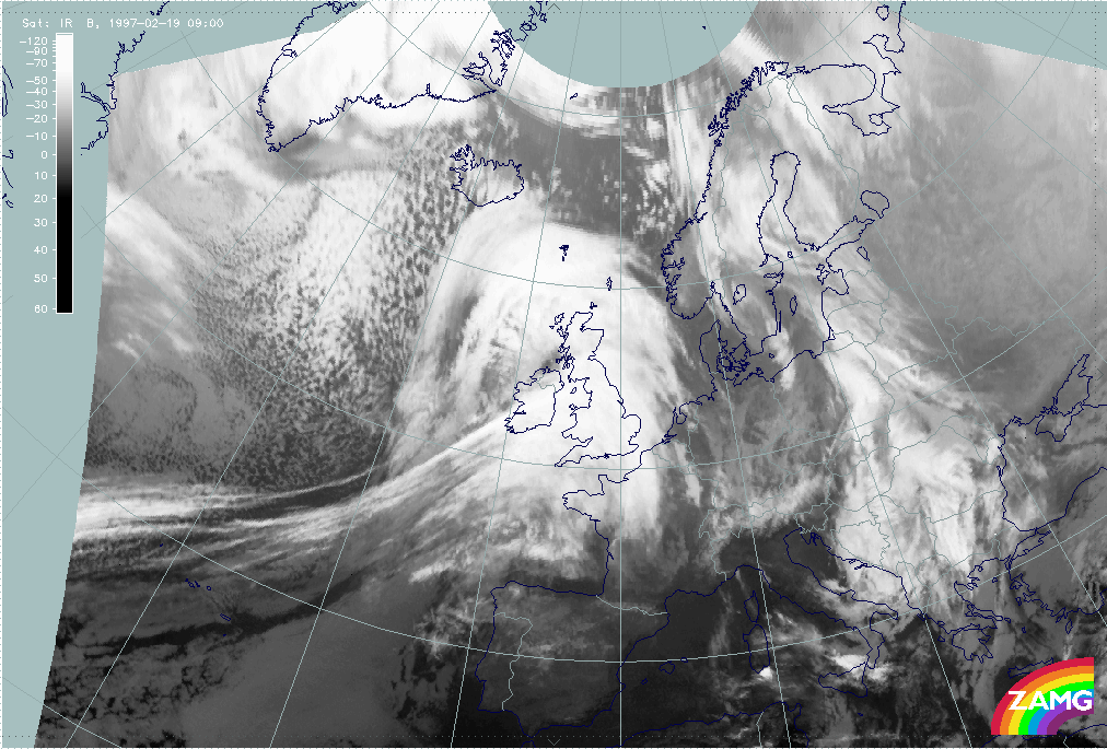
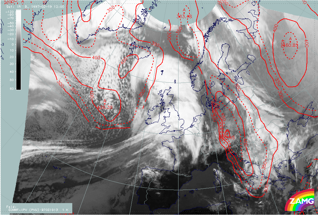
19 February 1997 - Verification Of Very Short Range Forecast
|
19 February 1997/09.00 UTC - Meteosat IR image
|
19 February 1997/12.00 UTC - Meteosat IR image; red: height of PV = 2 units
|
|
|
|
|
|
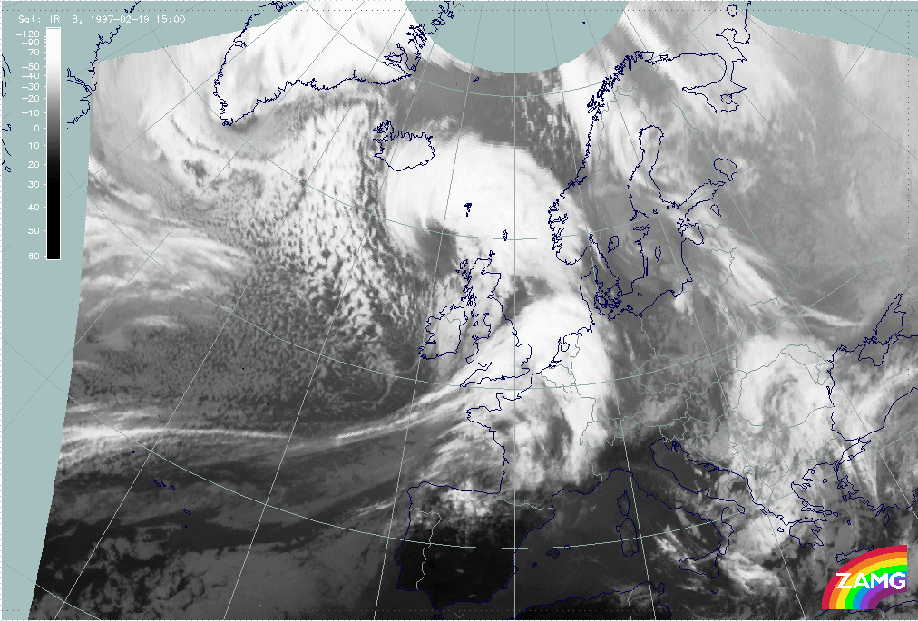
19 February 1997/15.00 UTC - Meteosat IR image
|
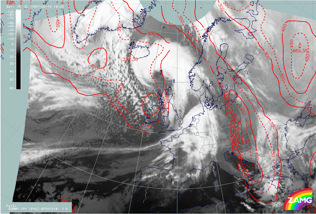
19 February 1997/18.00 UTC - Meteosat IR image; red: height of PV = 2 units
|
The three-hourly sequence of IR images shows very impressively the development of an Occlusion cloud spiral in the area of the Rapid Cyclogenesis, and the development of a Comma cloud feature at the rear side of the frontal cloud band which crosses Ireland and moves towards England.