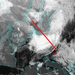
The maximum of wind speed is at 300 hPa, behind the frontal zone, in the left exit region of the jet streak. High pixel values on the satellite image again is associeted with intensification of the frontal cloudiness.
Vorticity Advection
The PVA maximum at the left exit region of the jet streak is an indication for further intensification and further development of the frontal system.
Omega
There is upward motion in a wide area, exhibiting two maxima; one ahead of the front at 850 hPa and the other along the front from 900 to 550 hPa and also at 400 hPa. Moreover, the upward motion extends through a thick layer, especially at the position of the convergence, where upward motion is seen reaching up to 300 hPa.
Potential Vorticity
The potential vorticity shows an anomaly (values between one and two units) along the rear cloud edge of the cold front. The anomaly, which separates the tropospheric from the stratospheric air shows the intrusion of the cold and dry air to the approximate 700 hPa which can be seen also in the WV images.
Temperature Advection
Still simillar distribution of temperature advection like at inital stage, however the warm advection is weaker.