The Training Bulletin

Joint newsletter related to new activities and resources
in European meteorological training

// issue XX - December 2020

Activities & events
//image missing//

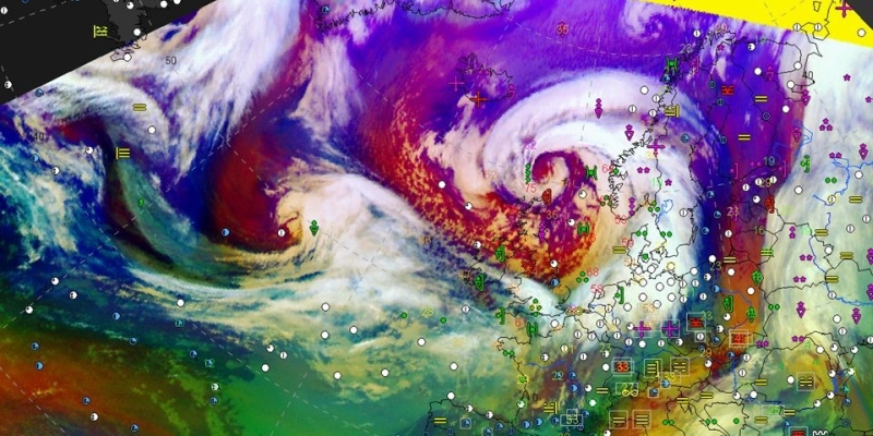
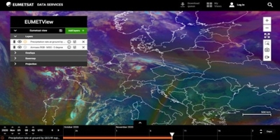
Precipitation Event Week
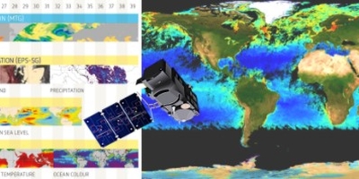
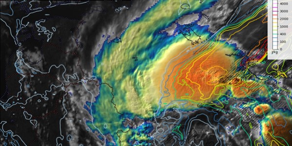
14 to 18 December 2020 / Online

This month EUMeTrain, in collaboration with the Support to Operational Hydrology and Water Management SAF (H SAF), is holding an event week on precipitation. Precipitation is the most important variable in Earth's hydrological budget, being the major component of water cycle. For this reason, the better understanding of the spatial and temporal distribution of precipitation, and its quantification, is fundamental for any hydrological and climatological application. Although surface precipitation gauges are considered the standard devices for precipitation measurements, in many areas they are sparse or not available (e.g. ocean and remote regions). This, combined with the temporal and spatial variability of precipitation occurrence, phase, and intensity, makes monitoring and estimation of global precipitation very challenging. Meteorological satellites provide a unique opportunity for global precipitation monitoring, and recent advances in Earth Observation technology allow for accurate precipitation estimates at spatial and temporal scales, which are useful for several applications.

H SAF products and applications fit with the objectives of services, agencies, authorities and other initiatives which need information on water at the ground in order to monitor hazards and natural disasters such as flash floods, landslides and drought conditions, as well as to improve water management.

The agenda and the registrations will be available soon on the EUMeTrain website.

//image missing//

Online course 'Synoptic and mesoscale system analyses'

11 January 2021 to 22 February 2021 / Online

EUMeTrain, in co-operation with EUMETCAL and EUMETSAT, is offering the online course 'Synoptic and mesoscale system analyses'.

This course will focus on improving forecaster skills by using the available satellite data in synoptic and mesoscale analysis. The participants will learn to use the satellite imagery, in combination with other meteorological data sources, in order to interpret mid-latitude cyclones, fronts, frontal sub-structures, mesoscale features in cold air, summer convection, orographic features, and shallow clouds. The course will include self-guided study, in combination with online presentations, quizzes and playground sessions.

The trainers will include Wilfried Jacobs (DWD), Vesa Nietosvaara (EUMETSAT), Rob Groenland (KNMI), Andreas Wirth (ZAMG), Jurgen Buelens (Meteo Wing – BAF) and Peter Schmitt (DWD).

The registration for the course closed in November.

//image missing//

The 2021 series of online short courses by EUMETSAT

starting January 2021 / Online

After a busy autumn of short courses on data discovery for weather, oceanography, air quality and climate we are happy to announce the start of the 2021 series.

The 2021 series will start in January, with a first course on 20 January on Learn to use an R based toolbox to analyse climate time series - Basics with Christine Traeger Chatterjee, Steffen Kothe and Danny Parsons.

The online courses are open to all and address a wide audience, from service providers to scientists and forecasters. The typical format will be a 1-2 hour webinar, including a presentation and demonstration of data discovery and application. You will have the opportunity to interact with experts and ask questions. Some courses will include a follow-up self-paced phase where you are invited to explore the data and get feedback from experts.

All training events will be timely announced in the EUM/VLab Training Calendar and on the EUMETSAT Moodle page. Registration is required.

//image missing//

Find out about the new Eumetcal webinars

Online

EUMETCAL has launched a series of short webinars. Lasting around one hour, these webinars address various environmental topics and are open to all interested participants.

At the first webinar in October, Rob Groenland, a meteorologist at KNMI, presented the plans for an early warning centre at KNMI. Watch the recording

The next webinar will be on 9 December at 09:00 UTC, when Torben Koenigk, climate researcher at SMHI, will talk about 'Future climate change: New results from the EC-earth climate model'. Sign up for the December webinar

A presentation on 'SINFONY - The Seamless INtegrated Forecasting sYstem of DWD' is planned for 26 January at 09:00 UTC. More information to come.

If you would like to be added to the mailing list, sign up using the signup form.

If you have any ideas of future subjects please contact info@eumetcal.eu

All events can also be found in the Training Catalogue.

//image missing//

ESSL Online Course 'Forecasting of Severe Convection'

3 to 7 May 2021 / Online

This course covers the basics of forecasting severe convection using an ingredients-based approach. It is ESSL's standard severe storms forecasting course, being led by Dr Tomáš Púčik, a trainer and a severe storms researcher at ESSL and a forecaster at ESTOFEX.

During morning lectures each of the ingredients for severe storms will be covered, including:

  • The effect of vertical wind shear and its influence on the organisation of convection into single cells, multi-cells, or supercells.
  • The dynamics of these conceptual models related to the potential for severe weather.
  • Synoptic and mesoscale patterns that can support or suppress the risk of severe convection.
  • The occurrence of severe weather hazards such as hail, extreme rainfall, tornadoes and severe wind gusts,, along with their relation to the large-scale conditions and individual storm types.

In the afternoon, exercises will involve forecasting convection either in near-real-time or for past cases across Europe. After the forecast, a discussion will follow with an emphasis on the subject that was studied during the morning.

Find out more about the course and how to register here.

// issue XX - December 2020

Resources & Tools
//image missing//

The new EUMETView map service is now available

Online

The new EUMETView is an Online Map Service allowing map creation and data query of EUMETSAT products, through a modern web user interface (WebUI) and an enhanced set of Open Geospatial Consortium (OGC) standard application programming interfaces (APIs).

Through EUMETView, users can access a wide portfolio of EUMETSAT product visualisations from different platforms, including near-real time visualisations of its core missions. The Web User Interface is highly customisable, allowing users to interact with visualisations in time and space, personalise the data viewing, create maps, and save settings for future use. Available products can be easily displayed as maps, but they can also be queried as point-based information and as time series. Maps can be animated and downloaded, and can be shared with other users.

Through available API Interfaces (WMS, WFS, WCS), users will be able to access EUMETSAT products from their own premises and to integrate EUMETView with their own cloud services. These APIs are going to support batch download and subsetting of the datasets used to create the visualisations, thus limiting the necessary data transfers and processing work performed by the user to extract the region of interest.

Access EUMETView. You can also register for access to additional products.

//image missing//

Improved data access and customisation with the EUMETSAT Data Store and Data Tailor

Online

The EUMETSAT Data Store provides users with a single point of access to a growing catalogue of EUMETSAT's meteorological, climate and ocean data. Users can browse, search and download available data using a web graphical user interface (GUI) or via APIs. Currently, the catalogue includes near real-time and historic data, as well as climate data records, from Meteosat and Metop missions, as well as satellite applications facility products. More products, including those from Copernicus missions, will be added incrementally. The Data Store supports data customisation, passing products to the Data Tailor Web Service (DTWS).

The DTWS exposes the functionality of the Data Tailor product customisation toolbox via a web GUI and REST API. It allows users to subset and aggregate data products in space and time, filter layers, generate quicklooks, re-project onto new coordinate reference systems, and reformat into popular geospatial formats (netCDF, GeoTIFF, etc.). It offers a uniform way to transform both historical and near real-time satellite data provided by EUMETSAT.

Users can use the Data Tailor via the DTWS, or install it on their own machine and access it using the REST API, command-line interface, or Python package.

//image missing//

Did you check out the new interface for the EUM/VLab Training Calendar?

Online

The Training Calendar is a collection of future satellite training events from EUMETSAT, the VLab and partners around the world. You can access it at http://trainingevents.eumetsat.int/.

Following a change to a new application framework, the calendar benefits from a fresh, user-friendly navigation enabling users to search across events, filter events by event type, region and language. After clicking on an event, a full event view provides additional useful information such as how to apply or the training competences covered.

Another highlight of this release is that the event entries in the calendar are now synced with the WMO Learning Calendar, making satellite training events now widely accessible from both platforms.

//image missing//

Quick Guide on Fire Temperature RGB – preparation for MTG Imager

Online

A Quick Guide on Fire Temperature RGB was recently published on the EUMeTrain website.

The Fire Temperature RGB is a candidate to become a standard RGB, to be created using the imager (FCI) on the future Meteosat Third Generation satellites. It uses the 2.25 μm channel, which will be an addition with the FCI instrument. The FCI IR3.8 channel is not new, but has been specifically redesigned to improve fire detection (extended dynamical range and a slight shift). In this Quick Guide, VIIRS images are used as proxy data for the FCI.

This RGB is not only useful for fire detection, but it also provides a qualitative estimation of fire temperature.

During the night, fires are seen against dark backgrounds, while clouds are not seen. During the day, some surface features, water, and ice clouds can be identified.

The new guide contains examples of colour interpretation, guidelines, physical background, benefits and limitations.

//image missing//

Quick Guide on True Colour RGB – preparation for MTG Imager

Online

A Quick Guide on True Colour RGB was recently published on the EUMeTrain website.

The True Colour RGB will be a standard RGB, which will be created from the imagers (FCI) on the future Meteosat Third Generation satellites. In addition to the 0.6 μm channel, it also uses the 0.4 and 0.5 μm channels which will be new on FCI. In this Quick Guide VIIRS and MODIS images are used as proxy data for the future FCI.

The aim of this RGB type is monitoring aerosols; suspended particles and algae bloom in sea water; surface features, and providing true colour images.

The colours are close to those naturally observed. Different surface features can be identified: green/dry vegetated areas, deserts, oceans, snow/ice covered areas. Clouds and snow/ice have similar colours (bright white). Aerosols can be identified and differentiated from clouds. Sometimes the aerosol types (dust, volcanic ash, fire, smoke) can also be recognised. Deep, clean water bodies can be well distinguished against water that is rich in suspended matter or that is shallow, with sediments on the water floor. Algae blooms are also seen.

The new guide contains examples of colour interpretation, guidelines, physical background, benefits and limitations.

// issue XX - December 2020

Stories & Achievements
//image missing//

Recordings from the EUMETSAT short courses now openly accessible

Online

The first series of the short courses by EUMETSAT kicked off in September and offered a variety of topics, with theoretical and practical elements. The courses addressed a wide audience, with different levels of expertise, who benefitted from learning new things in new areas, or simply reinforcing their knowledge on the subject.

Overall, 591 participants from 65 countries around the world attended the first six short courses in the series. The participants assessed these virtual courses to be instructive and very useful, as well as an excellent opportunity to share knowledge.

For more information about the courses and to access all the recorded sessions, please visit the individual course pages on the EUMETSAT, under Past Events.

//image missing//

A great coordination: the WMO/FAO/EUMETSAT Virtual Agrometeorology Training Course

23 Nov to 11 Dec 2020 / Online

A joint training initiative aimed at building the capabilities of experts in south-eastern Europe in using satellite products and agrometeorological applications for drought monitoring, was launched on 23 November. More than 30 participants from more than 16 countries are active in this three-week course. Hosted on the WMO Moodle platform, the course is organised in six independent modules.

The six modules are:

  • EUMETSAT products and database access. Use of remotely-sensed land products.
  • H SAF Rainfall and Soil Moisture. Regional and global products.
  • Land SAF products and access.
  • JRC MARS European Crop Monitoring and Yield Forecasting System – approaches and tools.
  • FAO tools for agricultural drought monitoring (ASIS), climate service for agriculture and the FAO-AquaCrop model.
  • Central Eastern Europe. Drought monitoring with Meteo Romania and DMCSEE.

The organisers of the ambitious training initiative include WMO, the Food and Agriculture Organisation of the United Nations (FAO) and EUMETSAT, with the support of the Romanian National Meteorological Administration (Meteo-Romania) and its evolving Regional Agrometeorological Centre, the Belgian Meteorological Service, the Drought Management Centre for South Eastern Europe (DMCSEE), the Serbian Hydro-Meteorological Institute, and the Technical University of Wien.

//image missing//

Eumetcal Workshop

11 to 13 Nov / Online

Due to real world limitations, this year's EUMETCAL workshop was moved online. The three-day workshop was hosted on the Eumetcal WebEx training platform using an Open Space format - with no set agenda initially, instead the agenda was created during the workshop by the attendees. This enabled everyone to propose topics grounded in work-related needs and to share experiences or ideas.

Forty-eight participants from more than 18 countries participated. It was a new experience for most of the participants - both in terms of Open Space and the online format. The Miro board, a visual collaboration platform, was successfully used for note-keeping, sharing resources, agenda setting, and more.

Multiple discussions were hosted at the same time and participants were able to choose which one to participate in. Discussed topics ranged from satellite image interpretation to ways of making the subject of meteorology more popular among younger people.

Every day ended with a 'harvest' - a whole group meeting to share, summarise, and reflect on every topic and, where appropriate, to agree on an actionable plan ahead.

The group agree that this online setting and format was very valuable and could be a viable solution in the future.

//image missing//

Ocean training at EUMETSAT in 2020

Online

It has been a busy year for the EUMETSAT Ocean Training team and rapidly moving (and adapting) to a fully online training environment has had its challenges.

The "Using the Copernicus Marine Data Stream for Ocean Applications" June course, originally planned to be in Tallinn, Estonia, was successfully rearranged and run online. Subsequently, the later course in October was also successfully run online.

These courses were made up of a self-taught phase followed by a week-long virtual classroom phase hosted over Zoom, consisting of interactive tutorials, live demonstrations, group work, and 1:1 meetings. The highlights of the courses were seeing the varied mini projects which participants worked on during the week and what they had achieved.

In July, we collaborated with the International Oceanographic Data and Information Exchange" (IODE) of the "Intergovernmental Oceanographic Commission" (IOC) of UNESCO, the OceanTeacher Global Academy (OTGA) and the Copernicus Marine Environment Monitoring Service (CMEMS) to run a Train the Trainers course, supporting those involved in teaching marine sciences. This course provided participants with the tools and techniques to incorporate the use of Copernicus marine data from EUMETSAT and CMEMS into their own educational activities. Participants also learned how to use open access resources available through the Copernicus programme, and to develop their own resources.

Alongside these, the ocean training team at EUMETSAT also supported two courses organised by the GMES and Africa consortia, and the EUMETSAT Series of Short Courses, a series of open online courses on data discovery.

//image missing//

Second Joint ESA/EUMETSAT/ECMWF Online Training Course on Atmospheric Composition completed

16 to 20 Nov 2020 / Online

Organised in cooperation with ESA and CAMS, the second edition of the five-day course moved online this year, bringing together 30 participants from Europe and beyond.

The course offered morning lectures, live streamed on YouTube, and afternoon practical activities where attendees worked in groups. In the context of the practical sessions, participants tried out CAMS, aerosol and Sentinel-5P data. They also explored the capabilities of Python code in Jupyter notebooks and the Harp toolbox.

Participants spent three sessions developing, in groups, their own projects, which were presented on the last day of the course.

Morning lectures focused on air pollution and health, the role of satellites in pollution monitoring, and data quality offered by colleagues, among others, from ESA, LATMOS-CNRS, KNMI, FMI, BSC, Luftblick and BIRA-IASB.

Access all lecture recordings and additional resources.

//image missing//

European satellites grab attention in Brazil

4 to 6 September 2020 / Alagoas, Brazil

LAPIS is a laboratory for image analysis and processing (LAPIS) in the Federal University of Alagoas (Brazil). They responded to a strong demand for training on environmental applications, with seminars on soil or weather monitoring, which combine panel discussions with guided processing of imagery.

The last event in Natal, supported by EUMETSAT, focused on anthropogenic disasters in Brazil, as observed by the Sentinel suite of satellites.

These included:

  • The exceptional forest fires in the Amazon basin.
  • An oil spill off the coast of north-eastern Brazil.
  • The possible environmental factors in the spread of Covid-19, in cooperation with Natal federal university.

Among the panel members who discussed the social implication of the training there were representatives of indigenous communities, fisheries, the agricultural sector, the national institute for space research (INPE) and regional universities. The debates motivated the participants to find answers in data analysis and processing and responses to high profile issues covered by the media.

LAPIS has also a strong presence in the media through tutorials and newsletters, which keeps its managers aware of the areas of public interest.

//image missing//

Joint ESSL-EUMETSAT course "Optimal Use of Satellite Data in Forecasting Severe Convection"

16 to 19 November 2020 / Online

In November, for the first time jointly, ESSL and EUMETSAT organised an online course on severe convection, with a focus on optimal use of satellite data in the nowcast process.

The course consisted of morning lectures and afternoon exercises, focusing on four specific topics. The lectures were split into theoretical background and satellite perspective, whereas the exercises dealt with forecasting of the environment leading to convective storms and nowcasting using satellite data. The BlueJeans web conferencing tool was used for lectures and discussion, and in the practical part of the course the ESSL Weather data displayer tool was used for data analysis and forecast creation.

The topics treated in the course were:

  1. Ingredients based methodology - instability and moisture, CAPE, instability indices from satellite data (NWC SAF products, IASI sounder data)
  2. Forecasting likelihood of convective initiation – lift mechanisms, convective initiation in satellite data (moisture boundaries, automatic algorithms detecting initiation)
  3. Types of convective storms in changing vertical wind profile - from single cells to supercells and bow-echoes, identifying convective storm types and their properties using satellite data
  4. Forecasting intensity of convective storms and individual hazards – Cape-shear relations, nowcasting intensity using satellite data - Cold-ring, Cold-U/V, above anvil cirrus plumes, storm top divergence

The course showed that there is a need for training on satellite utility in nowcasting and for more information on satellite data and its accessibility.

//image missing//

MeteoSwiss' semi-annual virtual training event goes multilingual

September / MeteoSwiss (Zürich)

In September, the semi-annual training event called MeteoAtelier took place. Usually, MeteoSwiss forecasters and observers meet physically at their regional centres to learn about relevant topics, get the latest internal news and exchange, but this time was different, as Fabienne Werder explains:

"There was no whispering with the neighbour while the instructor was speaking. But still everyone was in the same room - at least, kind of. By using EUMETCAL's Webex platform and having everyone in one session, we tried to mix things up. Not an easy task, because we do not just have different regional centres, we also speak four different languages! After a morning of lectures about future forecaster-tasks and automated weather information systems, we sent the participants into different breakout sessions. They collaborated in groups speaking Italian, French & German and brought up their interesting ideas. Although the social contact was slightly missed, everyone quickly adapted to the new format of collaboration and profited from the functionalities of WebEx which allowed a broad variety of interactions."

//image missing//

SEEMET 2020 online training course

5 to 16 October 2020 (asynchronous preparatory phase); 19 to 22 October 2020 (synchronous) / Online

The fifth SEEMET (South-East Europe Meteorological Training), an advanced online course on the topic of Extratropical Cyclones, was successfully conducted in October. The course was delivered online due to the pandemic.

The course started with a preparatory phase, held from 5 to 16 October, where learners could review the training material prepared on the Eumetcal Moodle site. The goals of these two weeks were to refresh the learners' knowledge on meteorological concepts about mid-latitude cyclones and allow them time to produce their own case studies for the practical sessions to follow.

The subsequent four-day synchronous part consisted of live presentations, delivered by SEEMET, EUMETSAT, EUMeTrain and ECMWF trainers, and practical sessions, all held online using the EUMETSAT Zoom account. In total, there were eight presentation sessions and four practical sessions, during which ePort, simulator and Padlet tools were used.

In order to receive a certificate of completion learners were invited to complete a final quiz and the evaluation survey. Most of the participants passed the quiz with excellent results. In total, 14 participants successfully finished the course. The course evaluation showed that learners were very satisfied with the training conducted in an online mode, even though they missed the opportunity to engage and socialise in person with fellow learners and facilitators.

//image missing//

Event Week on IASI L2 Profiles

14 - 17 September 2020 / Online

The IASI L2 product contains temperature and humidity profiles which are available 30 minutes after sensing through the EARS-IASI service from EUMETSAT. The aim of this Event Week was to raise awareness of this product, with the understanding that the product usage is still in the early stages. Throughout the week, seven online lectures were given highlighting how these profiles are made, along with the verification of the data. Several presentations focused on the possible applications in convection, sting jets and assimilation of the data in NWP.

Although many of the applications are still under development, the participants got a good overview of the product and how it might be used in the future, especially in the view of MTG IRS.

The free event had 53 participants, with, on average, 27 attendees per session. All presentation recordings are published on the EUMeTrain website.

// issue XX - December 2020

Job Vacancies

Subscribe to the Job Vacancies tab by clicking on the button below and receive job advertisments when new training jobs are open.

//image missing//

Weather Applications and User Training Expert

Application deadline: 11 April 2021

Working for EUMETSAT, you can be a part of something that makes a positive impact on society.

EUMETSAT operates a fleet of satellites delivering weather and climate-related satellite data to our users worldwide; helping protect life, property and the various weather sensitive sectors of the economy from adverse weather impacts. The EUMETSAT training team is responsible for user training outreach activities in support of national services' exploitation of the EUMETSAT data to get the societal benefits outlined in our strategy.

EUMETSAT's team of training officers works across several application domains. This new 'Weather Applications and User Training Expert' post focusses on user training and outreach activities in support of applications across operational meteorology and hydrology. The target audiences will be operational staff, application developers and scientists. We welcome applications from Trainers experienced in the design, delivery and evaluation of training interventions and who have an understanding of meteorological services (specifically operational meteorology and hydrology) and the processes at work in generating forecasts. For additional information on the role and the application process please follow the link below.

Application URL: https://eumetsat.jobbase.io/job/6lovc2k4