The Training Bulletin Special Edition

Special edition: Online learning & training support in times of COVID-19

// issue 18 - Special Edition - April 2020


In the context of the COVID-19 pandemic outbreak, we find ourselves confronted with rapid changes in our daily lives which affect, among other things, also the way we are delivering training to our communities. Since we believe that continuous learning and access to training resources is important for both our professional and personal lives, we would like to dedicate this edition to online learning material, training tools and resources available for support to our wide community of users during this challenging time for us all.


We will continue to update the collection below to provide you with a variety of free and self-paced resources and tools that we have used in our training activities at EUMETSAT and EUMeTrain.

//image missing//

Training module on Cyclogenesis

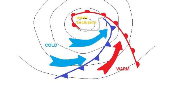
Frontal analyses of extra-tropical cyclones almost always follow the classical Norwegian scheme showing cold- and warm fronts and occlusions. Not infrequently, these analyses do not reflect the real situation as many of the cyclones being born over the Atlantic are of a different type. These cyclones often show a rapid development (a.k.a. Rapid Cyclogenesis) and do not occlude in the classical sense where a cold front caches-up a warm front. They show many differences compared to the Norwegian cyclones that are highlighted in this training module.

By showing development stages and real cases side by side, you will learn to identify both cyclone types from a combination of satellite images and numerical parameters. A basic knowledge on fronts and cyclogenesis is required. Frontal analysis will lead you through the development stages of both cyclone types. Finally, a quick look at "sting jets" closes the training module.

//image missing//

Massive Open Online Courses from Copernicus

A series of lessons (mostly video) about the ocean and atmosphere, with a focus on how to monitor them and what information can be obtained. The courses are structured in chapters, but you can just step in at any point.

Who are they for? Anyone who needs a broad understanding of the applications satellite data can be used for, and the main principles behind them.

Access them at:

//image missing//

Podcasts

A series of 45 minutes discussion around a hot topic with worldwide experts.

Who are they for? General audience.

Access them at: https://audioboom.com/posts/7530082-a-year-of-fires-2019-with-mark-parrington

//image missing//

YouTube videos

Various videos explaining EUMETSAT programmes, the satellites we operate and their instruments, and examples of how satellite data is used and what it can tell us.

Who are they for? General audience.

Access them at https://www.youtube.com/user/EUMETSAT1.

//image missing//

COMET Modules

Online asynchronous modules on different topics related to geosciences with a focus on meteorology, atmospheric sciences and climate provided by MetEd. MetEd is populated and maintained by the COMET® Program, which is part of the University Corporation for Atmospheric Research's (UCAR's) Community Programs (UCP). EUMETSAT contributed to a number of them, dealing with subject around meteorological satellites.

Who are they for? COMET modules are available for different skill levels.

Access them at https://www.meted.ucar.edu/index.php. The modules are available at no costs upon registration with COMET.

//image missing//

EUMeTrain Resources

Many resources on different topics of satellite meteorology can be found on the EUMeTrain website.

Who are they for? The resources are primarily made for forecasters, but also other meteorologists can benefit from them.

Find here the guide through EUMeTrain resources here or access them directly by going to: http://eumetrain.org/resources.html

//image missing//

EUMeTrain Resources on Eumetcal's Catalogue

Many of the EUMeTrain's training resources have been added to the Eumetcal's Training Catalogue. This includes courses, product tutorials, training modules and event weeks.

All of EUMeTrain's resources listed in Training Catalogue can be found here. Most of them do not require account to be accessed.

//image missing//

Content from past EUMETSAT training courses

A Moodle-based learning platform used to coordinate online and blended courses at http://training.eumetsat.int.

Who are they for? Courses are typically thematic, and/or associated to specific satellite data streams. Online material includes material for reading, links to the videos above, guides for installing software, short activities, and discussion forums.

How to get access? If you would like to review and/or use some of the material on our Moodle platform, please contact copernicus.training@eumetsat.int and training@eumetsat.int to reach the appropriate teams.

//image missing//

Code repository of Jupyter notebooks and Python code

A git repository of code (in Jupyter notebooks and plain text Python scripts) supporting common user workflows (downloading, working with netcdf, batch processing, visualisation) and tutorials about Copernicus data (understanding what the data means, how algorithms work, applying flags etc.).

Who is it for? Those wanting to get hands on with data in a programming environment and begin to build their own code-based workflows and applications.

Access it at https://gitlab.eumetsat.int/eumetlab/atmosphere/atmosphere. Since the repositories are not publicly available please contact training@eumetsat.int first.

//image missing//

Data download web pages

//image missing//

YouTube Tutorials

A series of videos showing:

  • How to access satellite data from EUMETSAT and the missions it operates as part of the Copernicus programme.
  • Basics of working with different types of data, including ocean colour, SST and altimetry.

Who are they for? Anyone wishing to learn how to download and work with various satellite data and tools available from EUMETSAT.

Access the playlist here.

//image missing//

Data visualisation tools

  • McIDAS-V - can visualise scatter-plots, histograms, 3D sounder data (cross-sections, volume rendering), can be unstable with high volumes of data.
  • SIFT - newer visualisation tool, can digest many different data types, fast and snappy with highest resolution data, under development.
  • Panoply - netCDF, HDF and GRIB Data Viewer.
  • SNAP - ESA tool developed to visualise Sentinel data (part of Sentinel toolbox).
  • Extended list of various S/W for Manipulating or Displaying NetCDF Data.
//image missing//

Imagery viewers

Online platforms with of-the-shelf imagery from various satellite missions.

  • Worldview - quick overview of high-res imagery from polar orbiting satellites (e.g. MODIS, VIIRS, …) and satellite positions.
  • Eumetrain ePort - quick overview of satellite data/products + NWP overlays, with archive. See ePort Pro (more detailed) and the Javascript version (perfect for quick overview).
  • CIRA Slider - geostationary imagery from Meteosat, GOES and Himawari satellites - quick access, not always stable, nice for sharing imagery by creating links to selected domain and time span.
  • EO Browser | Sentinel Hub – visualisation of data form SLSTR and OLCI and Sentinel 1 and 2 missions.
  • GOES Image Viewer - gives a good idea of the sizes of single channels and some RGBs, in full resolution, full disc view.
  • RealEarth – many different products, GOES and Himawari.