Predictability
As mentioned above, the development of the Friederike cyclone was already forecast several days ahead by global numerical models. However, the deterministic forecasts changed from day to day in terms of the structure and intensity of the event (sometimes only a trough of low pressure was forecast). Forecasting of rapidly developing cyclones is still challenging because several factors must be present at the same time and at the right position: strong upper-air flow and an upper-air PV anomaly approaching a surface cyclone (or low-level PV anomaly). This means that the forecasts are highly sensitive to the initial conditions. Even if it develops in several EPS or deterministic runs, it is not always clear how large the impact of the storm will be and how extreme it will be. The ECMWF-EFI (Extreme Forecast Index) was one product that highlighted the extremeness of the 18 January 2018 situation and the region with EFI > 80% (80% probability of an extreme gust with respect to model climatology) nearly coincided with the distribution of the strongest-measured wind gusts and associated damages (Fig. 6.1).
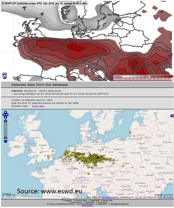
Figure 6.1: Top: ECMWF Extreme Forecast Index (EFI) for wind gusts, showing the percentage of EPS forecasts where the wind gust exceeds the model climatological maximum or minimum for 18 January 2018. The red (grey) shades refer to gusts stronger (weaker) than the maximum (minimum). In parts of the UK, Netherlands and Germany, extreme gusts were predicted by more than 80% of EPS members (48h forecast from 17 January 2018 00 UTC).
Bottom: Reports of severe weather on the European Severe Weather Database (ESWD) webpage relating to 18 January 2018.
We could also compare the fields of earlier runs (from 11 January 2018 at 00 UTC, which forecast the cyclone, and the later 12 January 2018 00 UTC run, which was not successful). In comparing the course of mean sea level pressure (Fig. 6.2), one could see that the two runs considerably differed after 17 January 2018 06 UTC. This was the stage when the upper-air jet started to approach the surface cyclone. However, the reasons for the different evolution of the cyclone between the two runs were rather complicated.
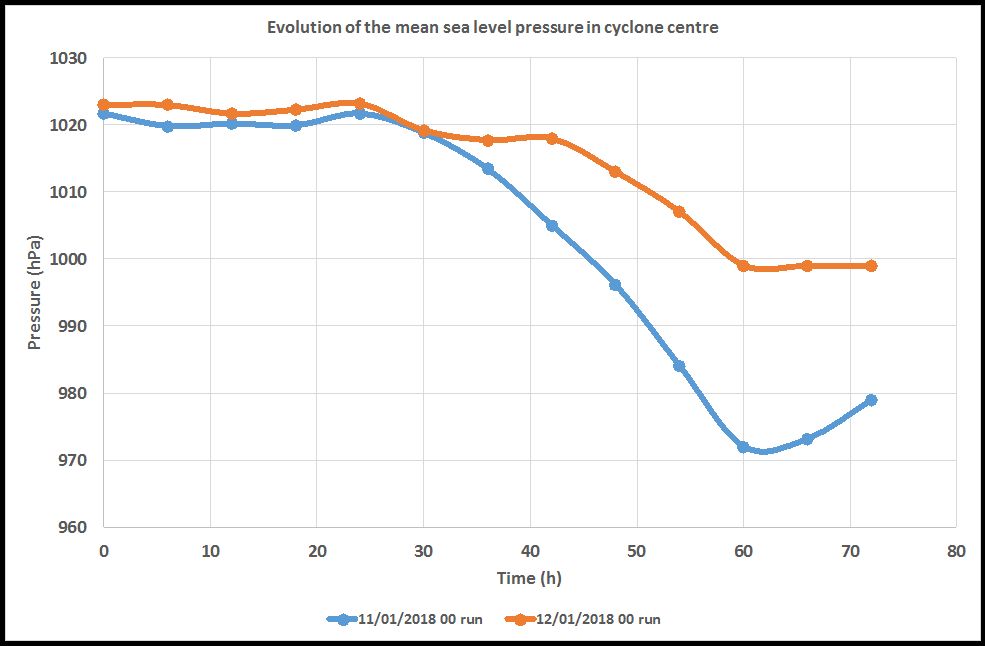
Figure 6.2: Development of mean sea level pressure (hPa) at the centre of the cyclone from 16 January 2018 00 UTC (0 h on the time-axis), for the ECMWF runs starting 11 January 2018 00 UTC (blue curve) and 12 January 2018 00 UTC (orange).
In the earlier (11 January) run, the frontogenetic processes at mid-levels and in the warm-frontal region were stronger (Fig. 6.3) than in the run 24 h later. This was probably due to stronger temperature advection and a larger temperature gradient in the 11 January 00 UTC forecasts (not shown). At the same time, the 850 hPa vorticity was also larger in this model run, just over the cyclone centre, which was probably also important.
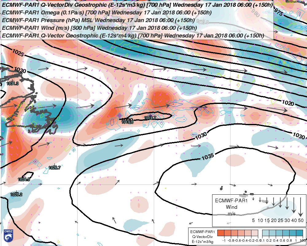
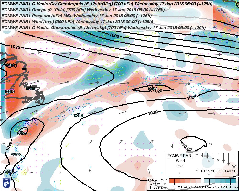
Figure 6.3: a) Left: ECMWF 150 h forecast of mean sea level pressure (hPa, lines), Q-vector divergence at 700 hPa (shades, 10-12 m3s/kg), Q-vector (small magenta vectors), omega velocity (coloured lines, Pa/s) and 700 hPa wind (large vectors, m/s) from the 11 January 2018 00 UTC run.
b) Right: The same but for the 12 January 2018 00 UTC run (valid at the same time)
At this 850 hPa level, a significant wind speed difference occurred between the two runs (Fig. 6.4). One could trace the origin of this difference more than 24 h backward (to 16 January 2018 06 UTC), to the eastern coast of the United States (not shown). From a macrosynoptic point of view, both runs were qualitatively similar until the cyclone started to deepen rapidly. Somewhat stronger low-level vorticity and mid-level vertical velocity created more favourable conditions for rapid deepening of the cyclone in the 11 January run. Such small differences at mid-levels could not be seen on the satellite imagery, which gives, rather, information about the upper-air features. For the 12 January 2018 00 UTC run, a mismatch between the 400 hPa forecast of relative humidity and the 6.2 μm water vapor images could be found, in a dry slot area, west-southwest of the cyclone's centre (not shown). The 11 January 00 UTC forecast (valid for 17 January 00 UTC) seemed to be more accurate. However, it is uncertain whether this inaccuracy also had a significant impact on the later evolution of the cyclone in the model.
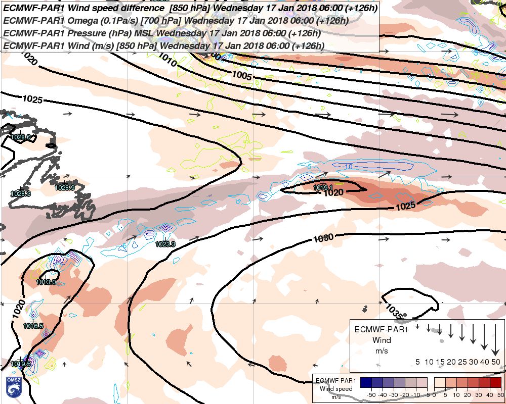
Figure 6.4: Difference in the 850 hPa wind speed (colour shades, m/s) between the 12 January 2018 00 UTC and 11 January 2018 00 UTC runs; mean sea level pressure (hPa, thick lines), omega vertical velocity (coloured lines, Pa/s) and 850 hPa wind (vectors, m/s), for the 126 h forecast of the 12 January 2018 00 UTC run, valid for 17 January 2018 06 UTC.