Short description of the case study
In early August 2016, a series of wildfires raged across Madeira Island, in the North Atlantic Ocean, prompting the evacuation of more than one thousand people, destroying about 105 homes as well as a five-star hotel in Funchal, the main city in Madeira, and causing the death of 4 people. Flights at Madeira airport were disrupted due to the smoke. The fires caused ca. 60 million euros in losses. An area of ca. 3000 hectares was burned.
From 4 to 10 August, Madeira was under the influence of a dry continental air mass from Northwest Africa and a possible foehn event may have locally increased the risk of fire. Fires started at 15:30 UTC on 8 August at S.Roque (fig.1.1) and lasted until 13 August. Madeira Island has a rough and mountainous topography, causing difficulties in fire fighting which in turn increased the impact.
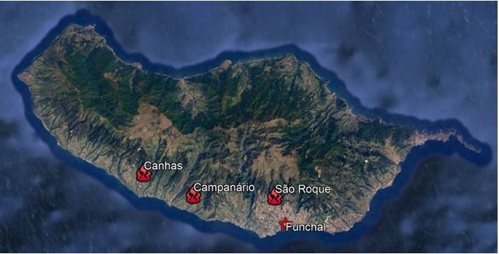
Figure 1.1: On 8 August 2016 a wildfire started at 15:30 UTC at São Roque, an administrative area of the main town of Funchal. On the same day, in Canhas and Campanário, West of Funchal, two more fires were detected (Google Earth).

Figure 1.2: View of Funchal, 9 August 2016. Photo: Gregorio Cunha/Lusa
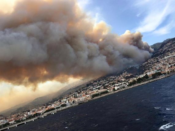
Figure 1.3: View of Funchal, 10 August 2016. Photo: D.R.(VIP Magazine)
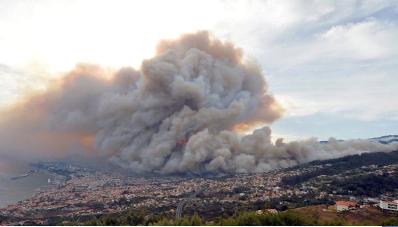
Figure 1.4: View of Funchal 10 August 2016. Photo: Helder Santos AP
Location and orography
The archipelago of Madeira is located 520 km west of the African coast and 1000 km south-west of the Iberian Peninsula (fig. 1.5). The island of Madeira constitutes the top of a massive shield volcano. It is the largest island of the group, with an area of 741 km2, a length of 54 km, while being ca. 23 km at its widest point and having a coastline of ca. 150 km. The coast is steep, especially in the northern part, with very high cliffs. It has a mountain ridge that extends along the centre of the island, reaching 1862 meters at its highest point (Pico Ruivo). The central mountainous area consists of several peaks, all reaching over 1500 m, as shown in figures 1.6 and 1.7.
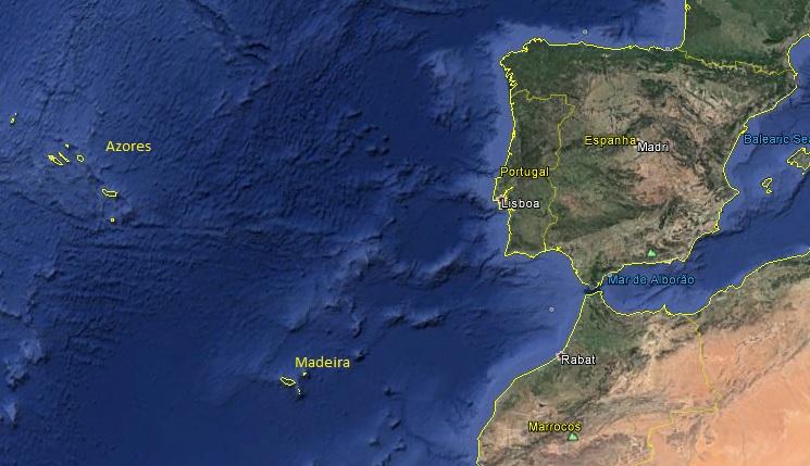
Figure 1.5: Location of Madeira Islands (Google Earth).
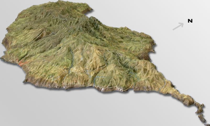
Figure 1.6: The main Island of Madeira Archipelago constitutes the top of a volcano and has a complex orography, with mountain peaks, valleys and ravines making the interior generally inaccessible. Photo by Luis Miguel P. Freitas (http://www.luisfreitas.pt/images/madeira_3d_este_luisfreitas.png)
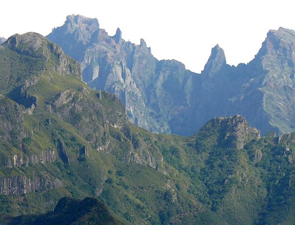
Figure 1.7: View from Bica da Cana (Madeira Island). Photo by Félix Potuit.
Climatology
The climate in Madeira shows a clear influence of both sub-tropical high pressure systems from Azores and from north-west Africa. This is very common from February to April and again from August to October. On these occasions the continental dry air mass from north-west Africa reaches Madeira and the easterly or north-easterly winds can last 3 to 7 days. In some winters though a polar air mass from the mid latitude region can reach further south and when this happens beyond the polar front, it is possible to have some cut-off lows affecting the weather. Madeira's climate is hot and dry in summer but there are differences between north- and south-facing regions as well as among some of the archipelago islands. In general, the windward side of the mountains is relatively moist and cool, while conditions at the lee side are relatively dry and hot. At the highest windward slopes of Madeira Island, rainfall can exceed 1250 mm per year, mostly falling between October and April, not only due to the main influence of both tropical and polar maritime air masses, but also due to orographic precipitation.
Figure 1.8 compares the temperature observations during August 2016 and the August climatological data at Funchal Observatório (automatic weather station located in the main town (fig. 1.9). Both maximum and minimum temperatures were above their normal during the 2016 event, when July was dry, not only in Funchal, but also in other areas, mainly at the lee side (cf. fig. 1.9). During the early days of August there was almost no rain on the island.
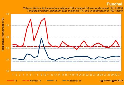
Figure 1.8: Daily maximum temperature (Tx), Daily minimum temperature (Tn) in August 2016 and monthly normal temperature for August at Funchal Observatório. Source: IPMA
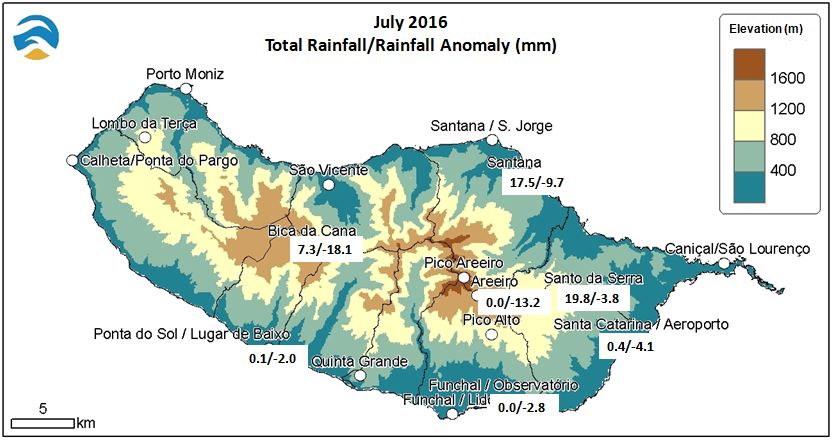
Figure 1.9: Total amount of precipitation and precipitation anomalies for some weather stations for July 2016 (as they are recent, not all weather stations have data on climatology). Source: IPMA
In recent years, drought conditions, coupled with hot and windy weather in summer, have caused numerous wildfires in Madeira. The largest of the fires, in August 2010, burned through 95 percent of the Funchal Ecological Park, a 1000 ha reserve set aside to restore the native vegetation of the island. In July 2012, wildfires broke out on 18 July, with temperatures near 40 °C and high winds. In August 2013, a hospital and some private homes were evacuated as a wildfire approached Funchal.
Weather and vegetation as related to pre-conditions to fire
The potential for the occurrence and development of wildfires depends on the interaction between the state of the vegetation and air temperature, degree of atmospheric dryness and wind speed and also topography. The effects of topography on the spread of fire are complex but, in general, steep slopes cause fire to spread faster.
During the summer of 2016, the amount of rainfall was generally below climatological values on the lee side of the mountains in Madeira Island. These conditions reduced the amount of atmospheric moisture and increased the amount of flammable vegetation. Taking drought effects as a background state, a foehn event thus serves as an episodic source of potential fire disaster.