Authors
Meteorological and Hydrological Service of Croatia - DHMZNatasa Strelec Mahovic
Dunja Drvar
Dunja Placko Vrsnak
Introduction
The Mediterranean Sea is considered to be one of the most cyclogenetic areas in the world. It usually favours the development of weak low-pressure systems. However, occasionally the cyclones formed there are so active and quickly developing that they produce periods of very disturbed weather and can cause the whole series of severe weather events as they advance through the Mediterranean region. The heaviest extra-tropical rainfall events (up to 800 mm in 24 hours) have been recorded in the Mediterranean and rainfall cases of up to 100 or even 200 mm in 24 hours are rather frequent. In addition to that, cyclones in the Mediterranean usually cause very strong winds, especially bora at Croatian Adriatic coast, with speed that can reach 40 or 50 knots and gusts up to 70 knots.In many cases the development begins in or near the Genoa Bay in the mid Mediterranean. Cyclones then move either towards south-east, along the southern coast of Italy and end up in the eastern Meditteranean, or towards north-east, into the Adriatic, where in many cases they get stronger or trigger secondary cyclogenesis.
In this case the development started in the Mid Mediterranean and the cyclone moved north-east, into the Adriatic. The path of the cyclone was a very common one for the developments that start in or near the Genoa Bay. The cyclogenesis presented here was one in a row of cyclonic developments that occurred in south-easterly flow from 22 to 29 February 2004. Some of the cases where characterised by extreme precipitation (up to 300 mm in 24 hours) and by very strong bora wind on the Adriatic coast.
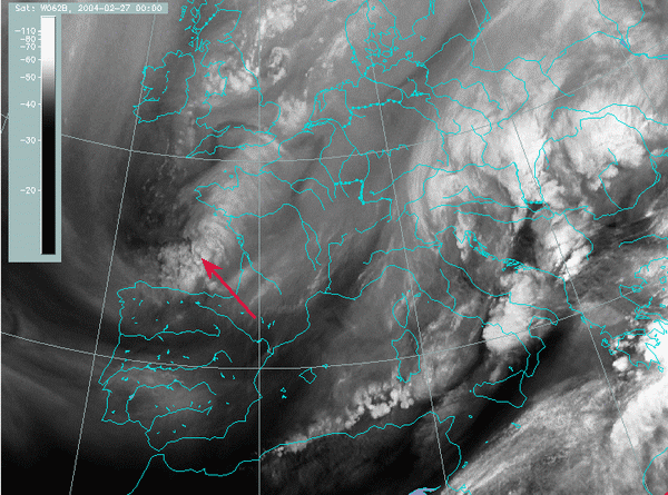
The case selected from this series of cyclones, was the one that started in the evening hours on 26 February. The initial development actually occurred in the Bay of Biscay (marked by an arrow in the image).

27 February 2004, 00 UTC - Meteosat-8; WV 6.2 μm channel
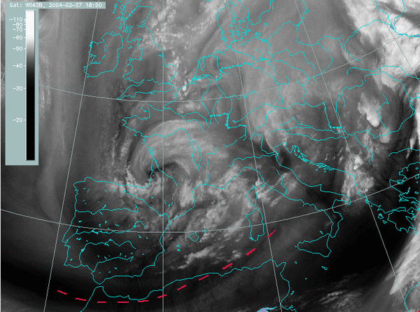
The cyclone then crossed the south France and north Spain and triggered the development in mid Mediterranean in the evening hours of 27 February 2004. Besides the influence of that already existing cyclone, the dark stripe in the WV image (marked by a red dashed line) crossing north Africa and ending in mid Mediterranean, indicates that jet stream also played an important role in this cyclogenesis.

27 February 2004, 18 UTC - Meteosat-8; WV 6.2 μm channel
In the various chapters of this case study one can follow the development as seen from the satellite and study the processes that led to cyclogenesis by looking at the fields of various numerical parameters.