Chapter V: LST From TIR Or Microwave Measurements?
Table of Contents
- Chapter V: LST From TIR Or Microwave Measurements?
- LST from TIR or microwave measurements?
LST from TIR or microwave measurements?
Remote sensing of LST is based on total radiative energy emitted by the ground . The surface's radiometric temperature can be determined from satellite measurements of emission at either infrared or microwave wavelengths. Due to the larger range of variation in surface emissivity uncertainties in microwave retrievals can be large in comparison to thermal infrared (TIR) retrievals of LST; the latter have a stronger correlation between radiance and temperature. However, measurements in the TIR are much more sensitive to cloud contamination than are microwave measurements. Indeed, the need for cloud detection can limit the spatial and temporal sampling of TIR measurements. Table I compares the advantages and drawbacks of these two types of measurements.
| Type of Measurement | Advantages | Caveats |
| TIR | Radiometric stable | Only available for clear sky classified pixels |
| Microwave | All weather situations (Microwave radiation penetrates clouds) | Uncertainties can be high due to the large range of emissivity - Lower accuracy (2-2.5K) Penetration depth of radiation Coarser spatial resolution |
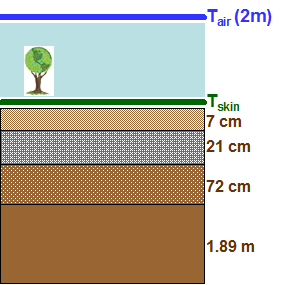
Two temperature measurements with the same spatial extent, performed in the TIR and microwave domains are not directly comparable. This is due to the fact that, whereas TIR LST corresponds to the top thin layer of a few micrometers (up to 50 μm) on the surface, microwave radiation comes from deeper down and depends on soil moisture. For most land surfaces microwave radiation penetration depth is assumed to be around 1 mm (Figure 27).

Fig. 27: Schematic illustration of surface penetration depth for microwave radiation (~1mm) compared to depth of the measured signal in the TIR (~50 μm).
In very dry areas with no vegetation microwave radiation penetrates much deeper in the surface, on the order of cm's (Ulaby et al., 1986). Figure 28 highlights how temperatures measured at distinct soil depths can differ (different curves correspond to soil temperatures measured at various depths (7 cm, 21 cm, 72 cm and 1.89 m)). Moreover, comparing this figure with the modelled diurnal cycles of Tskin and Tair for the same date and location (Figure 29), differences in the amplitudes and phases of these variables are clear: Tskin shows the highest thermal amplitude, followed by Tsoil at the first soil level and Tair.
 |
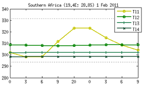 |
Fig. 28: Diurnal cycles of surface temperature measured at several soil layers (7 cm, 21 cm, 72 cm and 1.89 m) for a site at South Africa, February 2011.
|
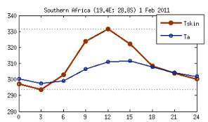 |
Fig. 29: Diurnal cycles of modelled skin temperature (Tskin) and 2 m air temperature (Tair) for a site in South Africa, February 2011.
In conclusion, it is expected that surface temperatures measured in the MIW domain, have a different amplitude and phase since they correspond to a different layer of soil.