Chapter V: Gravity Waves In Satellite Images
Table of Contents
- Chapter V: Gravity Waves In Satellite Images
- Low Level Gravity Waves
- Gravity Waves At Tropopause Level
- Exercise
Gravity Waves In Satellite Images
Gravity waves are a very common phenomenon in the atmosphere. They are generated in a fluid medium or at the interface between two media when the force of gravity or buoyancy tries to restore the hydrostatic equilibrium.

Figure 1: The atmosphere is in hydrostatic equilibrium when the pressure gradient force drawing air upwards from higher pressures near the surface to lower pressures aloft is balanced by the force of gravity pulling air back down to the surface. © The COMET Program
While lee waves are stationary waves related to surface elevations, gravity waves propagate horizontally through the troposphere. They are particularly common over the ocean because of its uniform background. Gravity waves are also found near the tropopause on top of cirrus anvils belonging to large convective systems and tropical cyclones. Gravity waves propagate over hundreds of kilometers under favorable meteorological conditions. They are visible in satellite images only if the air mass in which they propagate is near saturation, so that humidity condenses as soon as the air column is lifted.
Low Level Gravity Waves
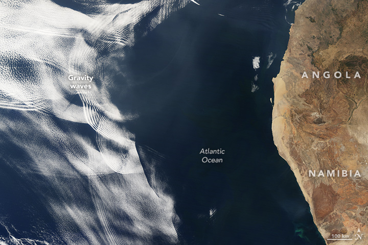
Figure 2: On 26 June, 2016, the Moderate Resolution Imaging Spectroradiometer (MODIS) on NASA's Terra satellite acquired this natural-color image of cloud gravity waves off the coast of Angola and Namibia (click on the image to get the loop).© NASA
Figure 2 shows gravity waves over the Atlantic Ocean. Fast-moving, warm air masses often sweep from east to west across African deserts, sending out surges of dry air over the Atlantic. When this dry air encounters moister and more stable air masses over the water, the clash can yield distinctive and beautiful wave patterns in the clouds which form at the transition of the two air masses. Such gravity waves can interfere with each other producing a distinctive crisscross pattern.
When a warm and dry air mass encounters humid air, it is lifted and will glide up on top of the cold air mass (figure 3). As it glides up, the warm air causes the underlying cold air to oscillate similar to a wind blowing over water. The force acting on the warm air when lifted to higher levels by the underlying cold air is answered by a counter-force (the force of inertia) of the warm air acting on the cold air layer. This counter-force drags the cold air down and away from hydrostatic stability. When the cold and humid air is pushed up again to higher altitudes, it may reach its dew point and the moisture condenses into droplets, forming clouds. When moist air goes up, it cools, and then gravity pushes it down again. As it plummets toward the surface, the air gets warmer than the surrounding air and is pushed up again by buoyancy as a result. Repeated again and again, this process creates gravity waves. Clouds form in areas of upward wave motion and evaporate in phases of downward motion.
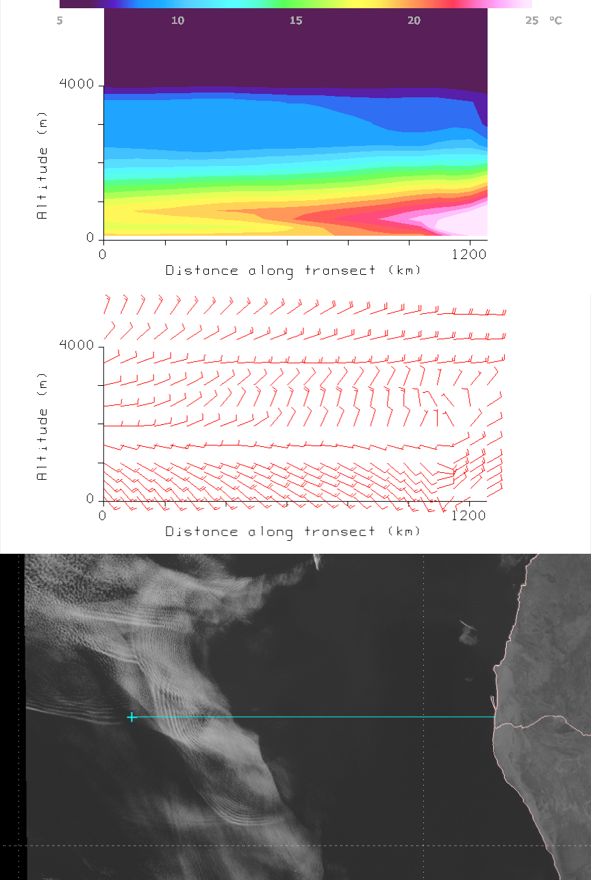
Figure 3: Met-10 HRV and GFS analysis comparison, 26 June 2016, 12:00 UTC
On rare occasions low level gravity waves can move against the background flow. This is the case when an obstacle in the flow causes the stable air to oscillate around its state of equilibrium. If the background flow is not too strong, gravity waves will propagate against the wind. Figure 4 shows thin fog advected over the Baltic Sea. When it reached the Danish Bornholm Island (maximum elevation 162 meters) its movement was partly blocked by the island, and an upstream wave developed due to this blocking. Moderate to dense fog bows formed as a result of the vertical motion of the fog layer.
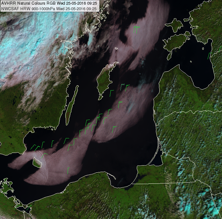
Figure 4: METOP-A AVHRR Natural Colours RGB and AMV wind barbs of the 900-1000 hPa layer retrieved from SEVIRI. © OMSZ
Gravity waves can also appear as a solitary wave and propagate as a disturbance that is characterized by a sudden and relatively permanent change in the height of a horizontal fluid interface. This type of atmospheric disturbance is also known as an undular bore.

Figure 5: On 2 July, 2013, the SEVIRI instrument aboard Meteosat-10 captured this view of an undular bore propagating westward off the coast of western Africa. © NASA
As can be seen in figure 5, the dry air from the African continent pushes up the moist air located over the Atlantic. The undular bore is the result of the clash of the two air masses. Typical undular bore patterns might display one or two rows of clouds; the above example shows more than 10 waves of clouds, which is unusually many. The air to the east of the bore is almost completely cloud-free because dry air would have eroded any clouds in that area.
A classic example of an undular bore is the morning glory phenomenon in Australia triggered by the sea breeze.
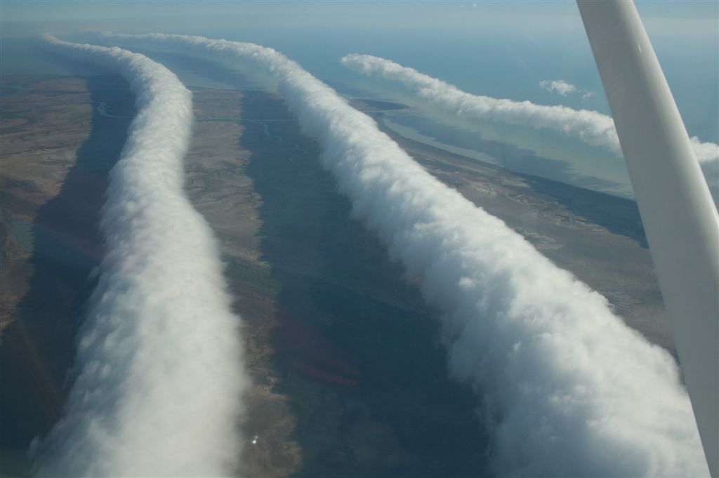
Figure 6: Aerial view of the Morning Glory cloud between Burketown and Normanton (Queensland, AUS). The appearance of several roll clouds is a rare phenomenon. © Mick Petroff, CC BY-SA 3.0
The Morning Glory cloud is a solitary wave propagating at about 60 km/h. It has a length of several hundred km but is only about 2 km wide and tall.
Undular bores can also occur in advance of cold air outflows that form an arc cloud. The example below (figure 7) is produced by the mistral wind flowing south along the Rhone valley and spreading cold polar air over the Gulf of Lion. The arc cloud forms at the transition between the warmer Mediterranean and the colder polar air. The humid air over the sea is lifted by the colder air arriving from the north above cloud condensation level (CCL) and is then pushed back by gravitational forces below CCL. The cloud arc can be interpreted as the mistral outflow boundary, which gradually progresses southwards.
Figure 7: MSG channel 12 (HRV) loop from 16 August, 2007. Rapid scan: 05:20 - 08:40 UTC.
Gravity waves can be generated by cold air outbreaks on a much smaller scale. They are often observed in the vicinity of thunderstorms (also called outflow boundaries or gust fronts). In some cases they are able to generate new convective cells due to the lifting effect in a potentially unstable air mass.
Outflow boundaries create low-level wind shear which can be hazardous during aircraft takeoffs and landings.
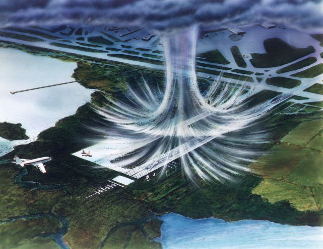
Figure 8: Illustration of a downburst over an airport. ©: NASA
Downbursts are frequently associated with thunderstorms. They are rather localized columns of cold air sinking rapidly due to gravitational forces. When downbursts reach the ground, they propagate horizontally until surface friction stops their spreading. Most of the time downbursts are not related to cloud formation, but when such a cold air downburst runs into moist and warm air it can lead to the development of an undular bore which is visible in satellite imagery.
The next example shows a very intense and wide-area convection episode in Botswana in the early morning. The HRV image loop below (figure 9) shows the outflow of cold air from a well-developed convective system which generates convection at the outflow boundary. The gravity wave propagating westward is clearly visible. Primarily it enhances shallow CBs by lifting the unstable air; in some cases this extra momentum is decisive for generating deep moist convection.
Figure 9: MSG channel 12 (HR-VIS) image loop of 19 January, 2015 from 04:00 - 16:00 UTC.
Gravity Waves At Tropopause Level
Circular wave patterns can often be observed in VIS imagery on top of high reaching convective cells. Gravity waves form around overshooting tops and propagate within the stable layer of the tropopause. In the case of strong upper level winds, gravity waves may develop only on the downwind side of the cirrus anvil.
The ice crystals at tropopause level oscillate due to pulsations of the buoyant air near the overshooting tops. The vertical pulses from the upwelling air propagate horizontally just below the capping inversion of the tropopause. The circular pattern of the waves on top of MCS anvils is similar to the wave pattern generated by a stone falling into a pond. These waves are best seen in HRV imagery at low solar angles (with shadows forming a better contrast).
Figure 10: MSG HR-VIS animation from 10:00 - 15:00 UTC on 29 June, 2006.
Apart from overshooting tops and gravity waves, the above HRV loop also shows radial cirrus. The origins of radial cirrus clouds are unclear, but they might be an indication for strong upper level divergence.
Circular gravity waves and radial cirrus clouds can also occur in tropical cyclones. Typhoon Mepartak (figure 11) had become a category 5 super typhoon with maximum wind speeds of more than 280 km/h on 6 July 2016. The high resolution visible images of Himawari-8 show the gravity waves south and southeast of the typhoon's eye. The reason for the circular gravity waves around the storm's eye are oscillations of the tropopause caused by the rotation and upward moving air in the central region of the storm around the eye.
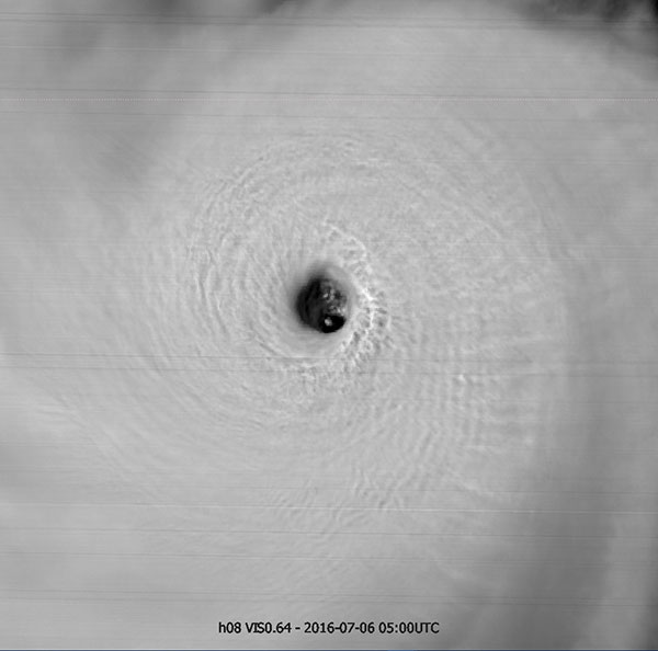
Figure 11: Himawari-8 VIS 0.64 μm image from 6 July, 2016 at 05:00 UTC. The image resolution is 375 meters.
Exercises
True or False
Select the correct sentences
The correct answers are: a), c), e)