Gravity Waves At Tropopause Level
Circular wave patterns can often be observed in VIS imagery on top of high reaching convective cells. Gravity waves form around overshooting tops and propagate within the stable layer of the tropopause. In the case of strong upper level winds, gravity waves may develop only on the downwind side of the cirrus anvil.
The ice crystals at tropopause level oscillate due to pulsations of the buoyant air near the overshooting tops. The vertical pulses from the upwelling air propagate horizontally just below the capping inversion of the tropopause. The circular pattern of the waves on top of MCS anvils is similar to the wave pattern generated by a stone falling into a pond. These waves are best seen in HRV imagery at low solar angles (with shadows forming a better contrast).
Figure 10: MSG HR-VIS animation from 10:00 - 15:00 UTC on 29 June, 2006.
Apart from overshooting tops and gravity waves, the above HRV loop also shows radial cirrus. The origins of radial cirrus clouds are unclear, but they might be an indication for strong upper level divergence.
Circular gravity waves and radial cirrus clouds can also occur in tropical cyclones. Typhoon Mepartak (figure 11) had become a category 5 super typhoon with maximum wind speeds of more than 280 km/h on 6 July 2016. The high resolution visible images of Himawari-8 show the gravity waves south and southeast of the typhoon's eye. The reason for the circular gravity waves around the storm's eye are oscillations of the tropopause caused by the rotation and upward moving air in the central region of the storm around the eye.
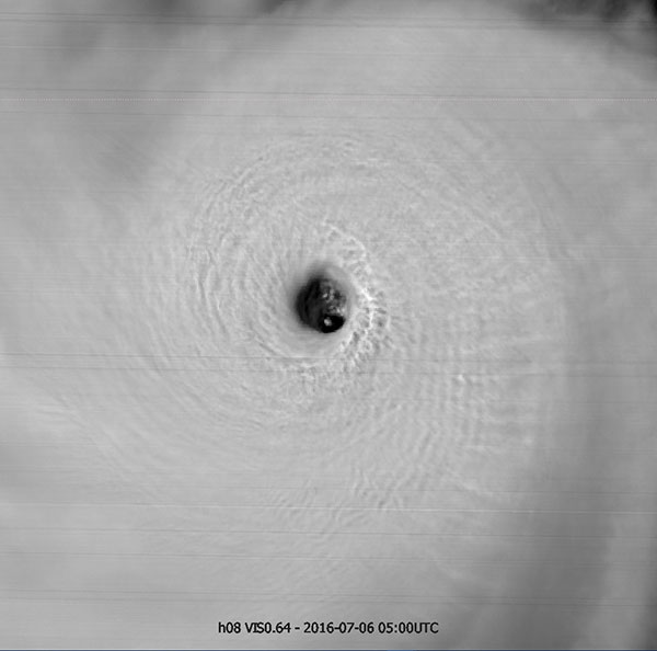
Figure 11: Himawari-8 VIS 0.64 μm image from 6 July, 2016 at 05:00 UTC. The image resolution is 375 meters.