Table of Contents
Introduction
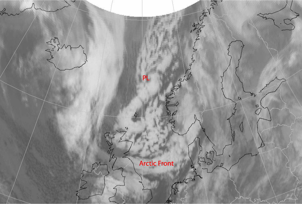
Polar lows are mesoscale depressions which occur in the northern and the southern hemisphere far to the north and south, respectively, of the Polar Front. In the northern hemisphere they normally appear between October and April. They develop in small baroclinic zones, originating from old Occlusions or Arctic Fronts, and particularly in situations where arctic air flows out over relatively warm sea water. Generally, the lifespan of a Polar Low does not extend beyond two days and they appear mainly over sea. There are often problems forecasting them because of the lack of observations from the open sea. After landfall, Polar Lows disappear quite fast. Polar Lows can produce high winds, gusts and heavy snow showers, often in clusters.
In this case a Polar Low affected North-western Europe between the 27th and 29th of January 2004. The Polar Low moved along the Norwegian coast then southwards in a northerly flow and turned over the North Sea in the direction of the German Bight. Eventually the Polar Low made landfall over the border between the northern parts of The Netherlands and Germany.
Theoretical Background
There are three stages of Polar Lows (see CM Polar Low): the developing stage, the mature stage and the decaying stage. In the developing stage
baroclinicy in combination with positive vorticity advection and potential vorticity in the upper levels is important for the development of
such a low. Convection is the driving force in the mature stage.
In most cases a Polar Low develops in a secondary baroclinic zone in polar or arctic air. This baroclinic zone can for instance originate from
the edges of ice fields in the far north of the Atlantic or from the remnants of Occlusions or Arctic Fronts. The cloudiness in this zone is
the result of positive vorticity advection and warm air advection. As it combines with extremely cold air in the upper levels, the atmosphere
becomes potentially unstable. The development of a Polar Low starts with the crossing of an upper level disturbance. This disturbance can be an
upper level trough, a jet-streak or an area of positive vorticity advection. The further development of a Polar Low continues when a low level
disturbance interacts with the upper level disturbance, especially in cases where artic air is flowing out over relatively warm sea water. The
big difference between the sea water temperature and the temperature of the air causes significant instability and temperature fluxes in the
lower layers of the troposphere. When a Polar Low reaches land the energy supply from the sea water is cut off. This, together with the
increased friction, causes the cohesion and structure of the Polar Low to rapidly decay. It sometimes occurs that Polar Lows, which developed
as result of very strong baroclinicy, are not dependant on sensitive and latent heat fluxes and continue to survive over land. This last
category of Polar Lows only disappears as a result of dynamic interactions, such as negative vorticity advection or cold air advection.
Polar lows are sometimes called arctic Hurricanes because they have some similarity to tropical Cyclones (spiral-shaped cloudiness, a cloud free eye). Theories concerning the development of tropical cyclones can also be (partly) applied to Polar Lows. One such theory is CISK. CISK means Conditional Instability of the Second Kind. An initial disturbance causes convergence and rising air, which in a conditionally unstable atmosphere causes the release of latent heat. This latent heat becomes available as a result of condensation of rising air. The air is heated and expands, consequently the surface pressure will start to fall. The pressure gradient increases with increasing convergence. This convergence causes upward motion of humid air, and so the process continues. This process of self-maintenance and strengthening is called positive feedback. The mechanism weakens over land, over colder seawater or when there is too much wind shear. The scale of CISK-forced disturbances is determined by the vertical distribution of diabatic heating during development. The growth rate depends on the amount of available potential energy (CAPE, Convective Available Potential Energy) in the atmosphere. During cold air outbreaks, which are extremely unstable, there is enough CAPE present for the development of Polar Lows. However, the question is whether there is enough CAPE over a longer period of time. The amount of CAPE (C) can be calculated using the following formula:
|
|
|

|
with
| C | maximum kinetic energy per unit mass | (m2s-2) |
| ZLFC | level of free convection | (m) |
| ZLNB | level of neutral buoyancy | (m) |
| g | magnitude of gravity | (ms-2) |
| T'v | temperature of the parcel | (K) |
| Tv | temperature of the environment | (K) |
Important for the convection to become organised is the appearance of an initial disturbance. This initial disturbance is often caused by baroclinic forcing, and sometimes by orographical or barotropic forcing. Moist convection plays a central role in the development of a lot of Polar Lows in contrast to the normal depressions which, in most cases, develop from a Wave in the polar front.
Description of the Synoptic Situation
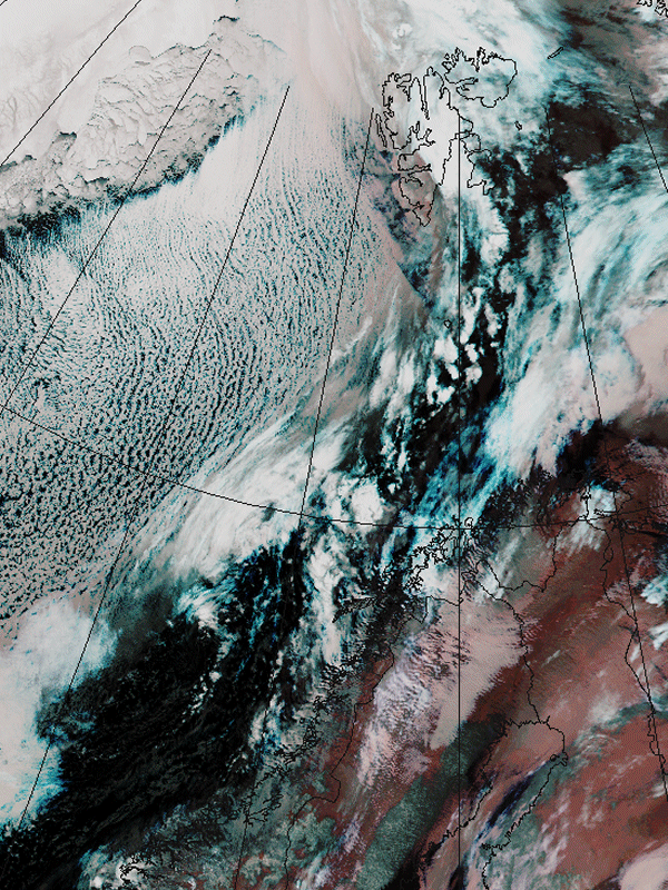
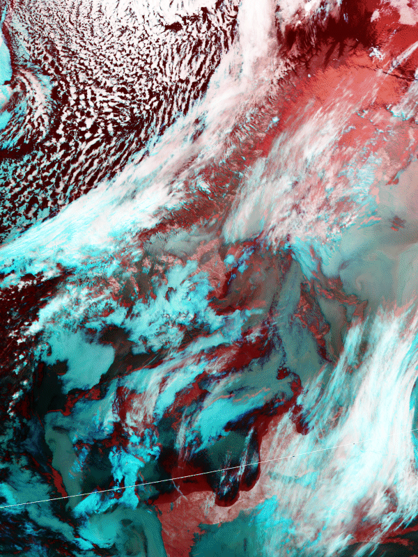
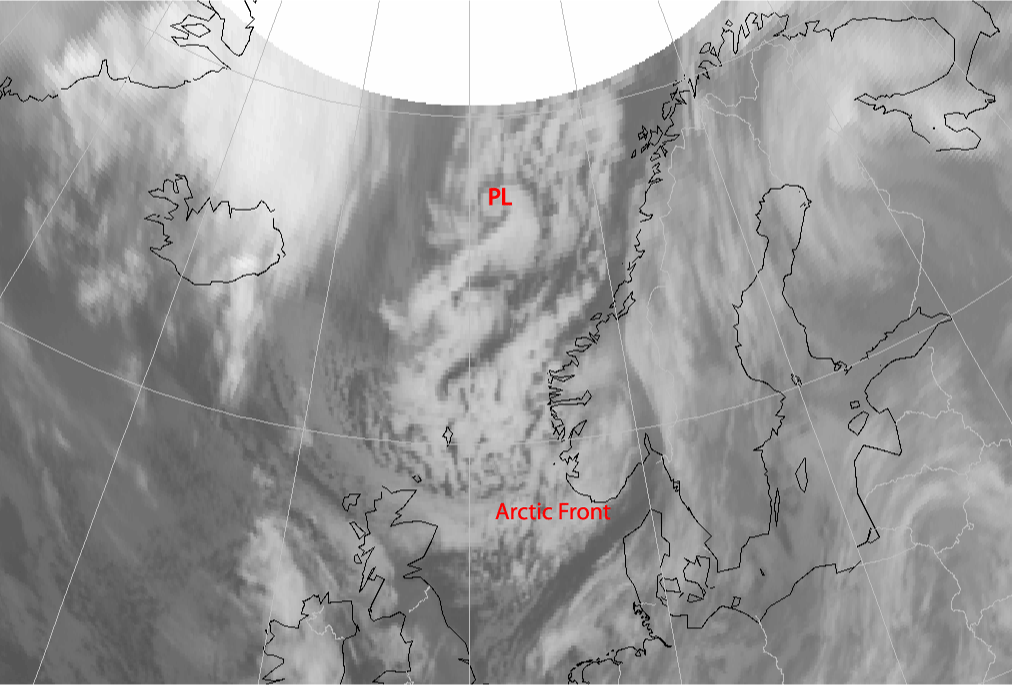
The satellite images of 25 January and 26 January show an extended area of Cloud Streets over the extreme north of the Atlantic, situated in an arctic air flown out from the mainland of Greenland. These images are NOAA high-resolution images, more specifically, a combination of the 3, 4 and 5 channels. Over the sea, in the area southeast of Greenland, the convective Cloud Streets lie in the direction of the outflow. The convective cloud streets are preceded by an Arctic Front. The Polar Low eventually develops in this air mass behind the arctic front.
|
25 January 2004/20.27 UTC - NOAA RGB image (channel 3, 4 and 5)
|
26 January 2004/11.52 UTC - NOAA RGB image (channel 3, 4 and 5)
|
|
|
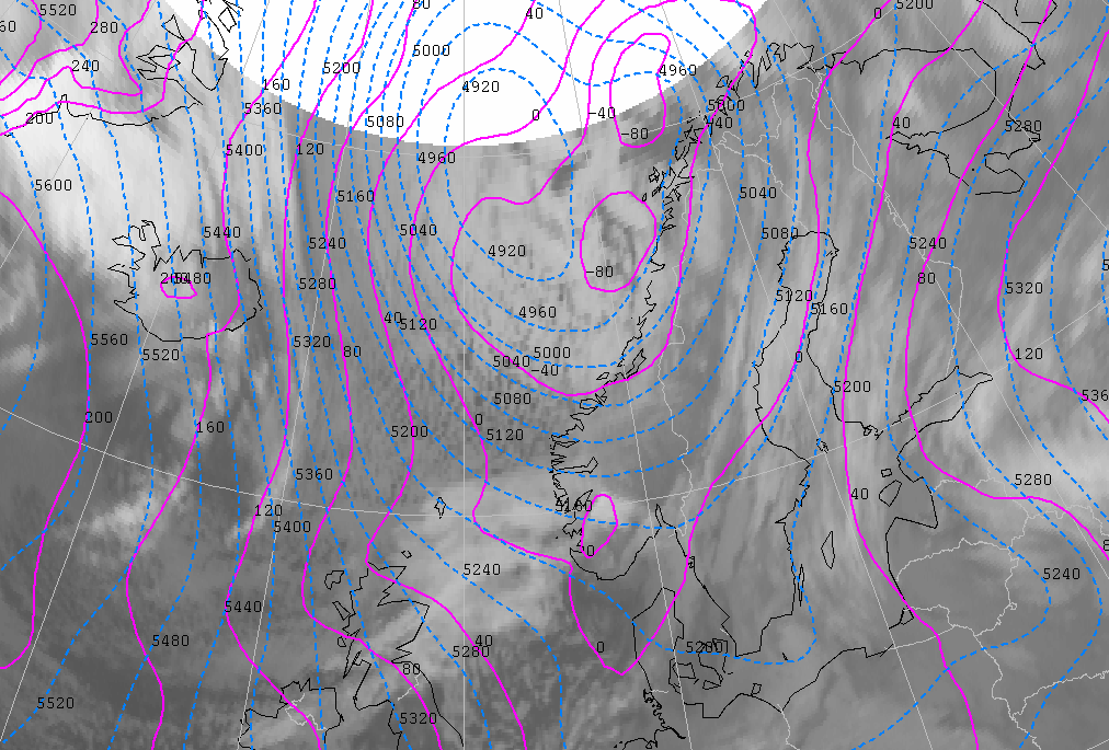
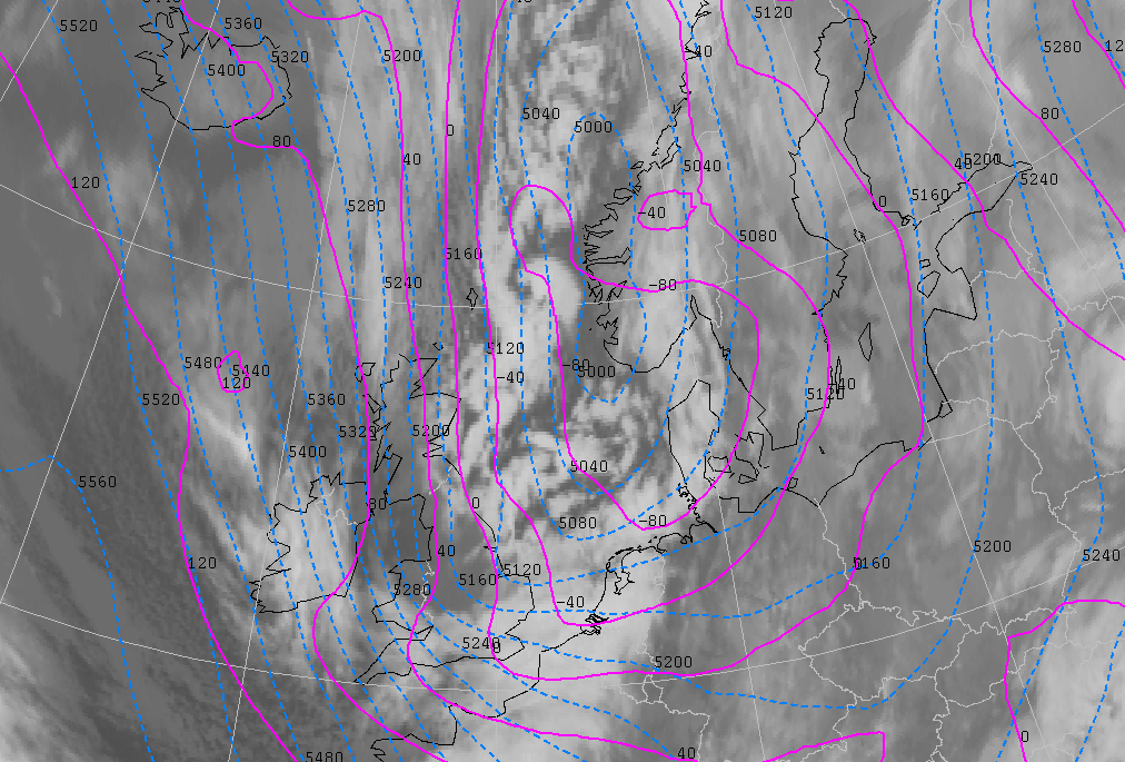
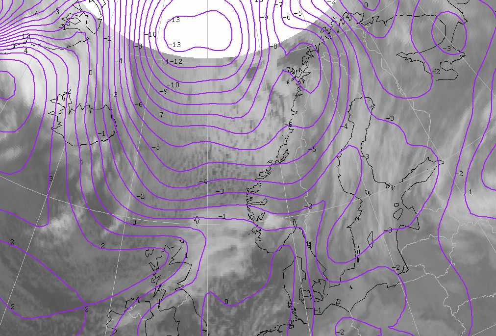
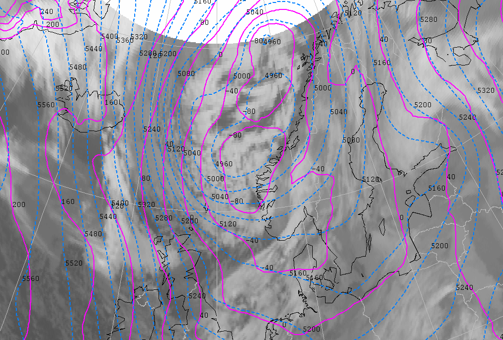
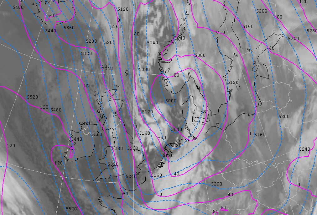
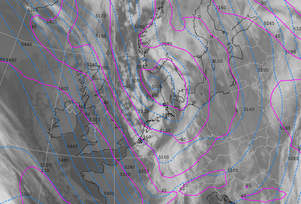
On 27 January 00.00 UTC there is an area of high pressure west of Ireland with a core pressure of 1030 hPa. At 500 hPa there are also high height values at almost the same position. There being a well developed low-pressure area north of Scandinavia, a northerly flow starts between Iceland and Norway, which transports arctic air southwards. On 28 and 29 January the high-pressure area slowly recedes southwards to the Azores, but there is still a strong ridge present in the direction of Greenland. The depression moves from the Norwegian coast to Denmark. The northerly flow persits for three days because of this situation. In the course of 29 January the flow gradually starts backing.
|
27 January 2004/12.00 UTC - Meteosat IR image; cyan: height contours 500 hPa, magenta: height contours 1000 hPa
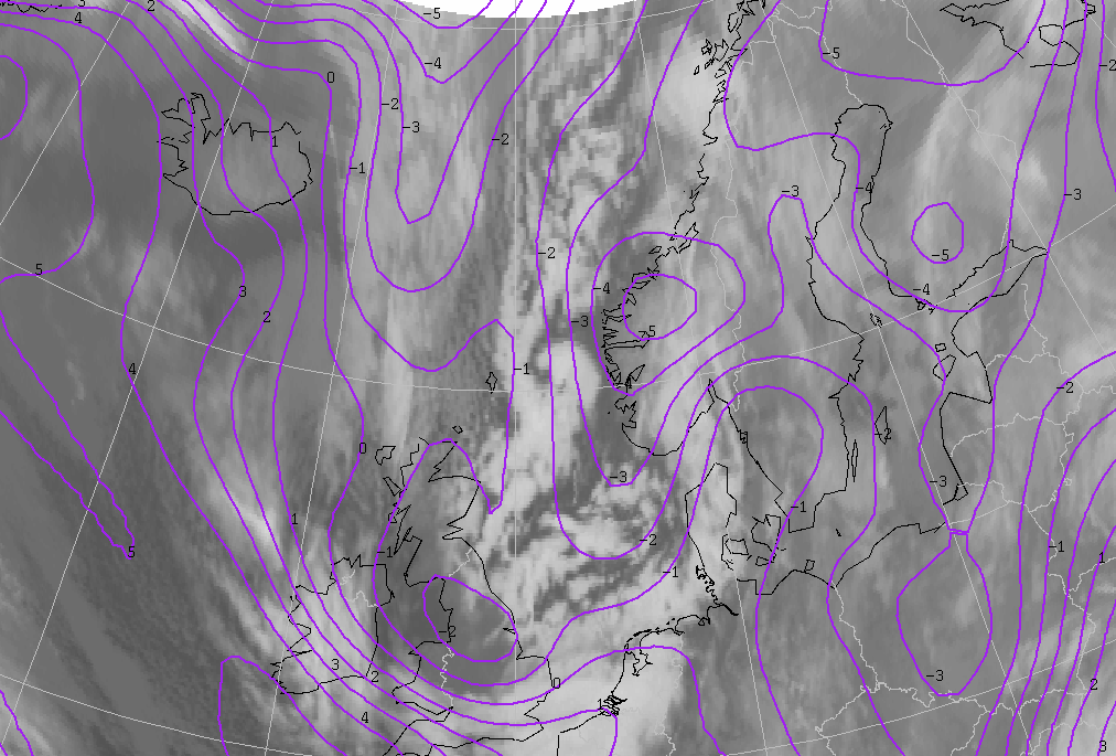
|
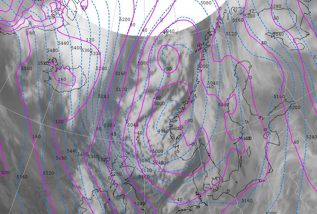
28 January 2004/18.00 UTC - Meteosat IR image; cyan: height contours 500 hPa, magenta: height contours 1000 hPa
|
|
|
Initially, the polar front lies from the Balkans, over Italy, northern Spain and the Atlantic Ocean. Over the next days the northerly flow over western Europe pushed the polar front further south, reaching northern Africa. The extremely cold arctic air coming directly from the North Pole is marked by the arctic front. On 27 January 12.00 UTC the most southern part of this arctic front lies between Iceland and Norway. In the next days the arctic front slowly moves southwards over the North Sea. The sharp temperature gradient at the beginning of this situation (27-1-04 12.00 UTC) weakens steadily as the arctic front moves southwards (28-1-2004 18.00 UTC). Warming of the lower layers occurs due to the warming by the sea.
|
27 January 2004/12.00 UTC - Meteosat IR image; magenta: ThetaW 850 hPa
|
28 January 2004/18.00 UTC - Meteosat IR image; magenta: ThetaW 850 hPa
|
|
|
The infrared satellite pictures of 27 January 02.00 UTC show typical convective cloudiness (many white spots) of an outbreak of cold air, to the northwest of Norway. The convective cloudiness moves southwards and begins to rotate cyclonically.
|
27 January 2004/02.00 UTC - Meteosat IR image
|
|
|
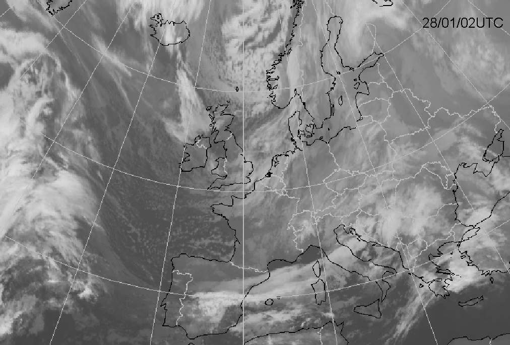
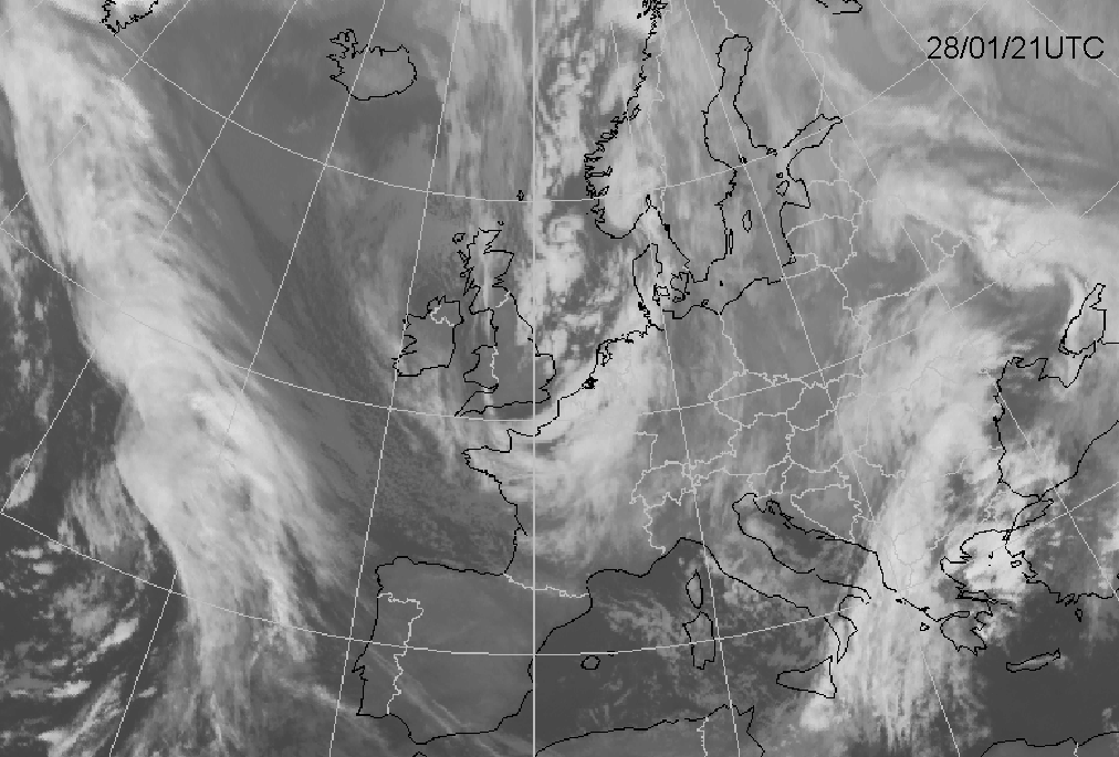
From the outset (27-1-04 00.00 UTC), the white spots grow quickly whiter and larger. This indicates fast growing, convective cloudiness. From 12.00 UTC on, the white spots start to merge together and the cloudiness starts to rotate. During the night of 28 January the arctic front (AF), preceding the arctic air, develop into a more distinct feature on the infrared satellite pictures. In the course of the night several curls can be seen which jointed together like an S-shaped spiral. These are located on the left side of the area of cloudiness and move towards Scotland (28 January 12.00 UTC). Once the first curl arrives there, it disappears. Wind gusts accompanying this curl reach a speed of more than 60 knots.
|
27 January 2004/12.00 UTC - Meteosat IR image; magenta: ThetaW 850 hPa
|
28 January 2004/18.00 UTC - Meteosat IR image; magenta: ThetaW 850 hPa
|
|
|
The Arctic Front (AF) merges with an area of cloudiness above Ireland and England and subsequently moves as one band of cloudiness into Western
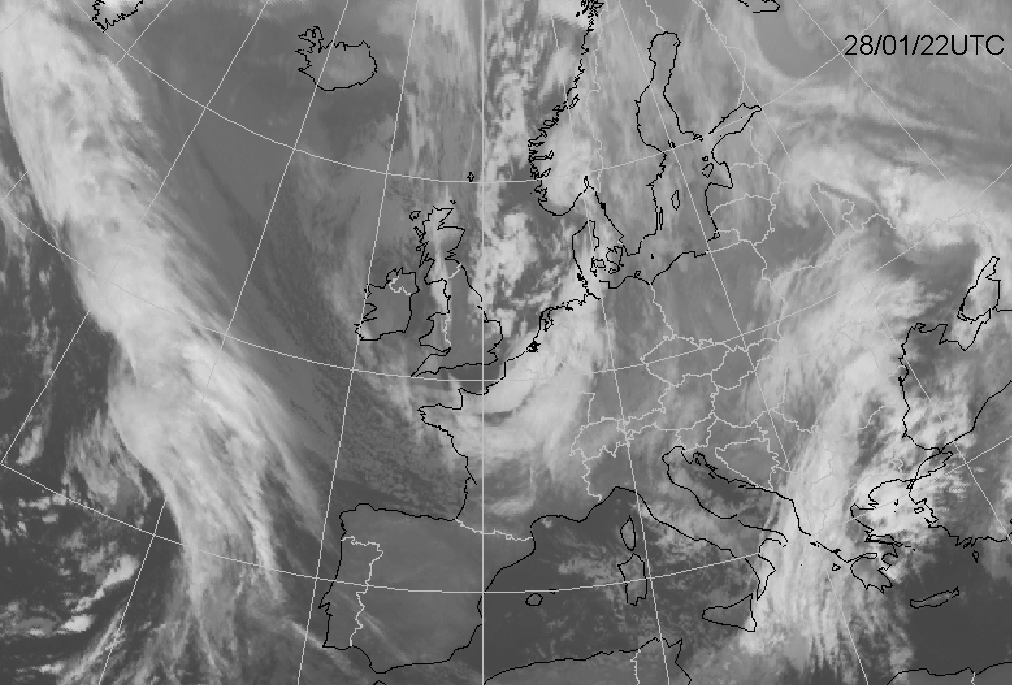
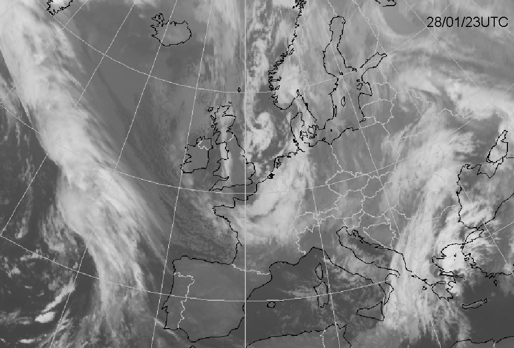
Europe. To the rear of this area, a broad band of clustered convective cloudiness appears, soon followed by the Polar Low (28 January 23.00
UTC).
The Polar Low is clearly seen on the first infrared satellite picture of 28 January 02.00 UTC. The development, however, lies too far north and
outside the view of the satellite. Around 09.00 UTC the spiral structure seems to disappear for a while. At 12.00 UTC the spiral structure
returns and at 23.00 UTC it is well developed lying over the North Sea. The maximum wind gust reported at this time is 61 knots, corresponding
wind force 11 on the Beaufort scale.
|
28 January 2004/02.00 UTC - Meteosat IR image; 28/23.00 - 29/06.00 UTC hourly image Loop
|
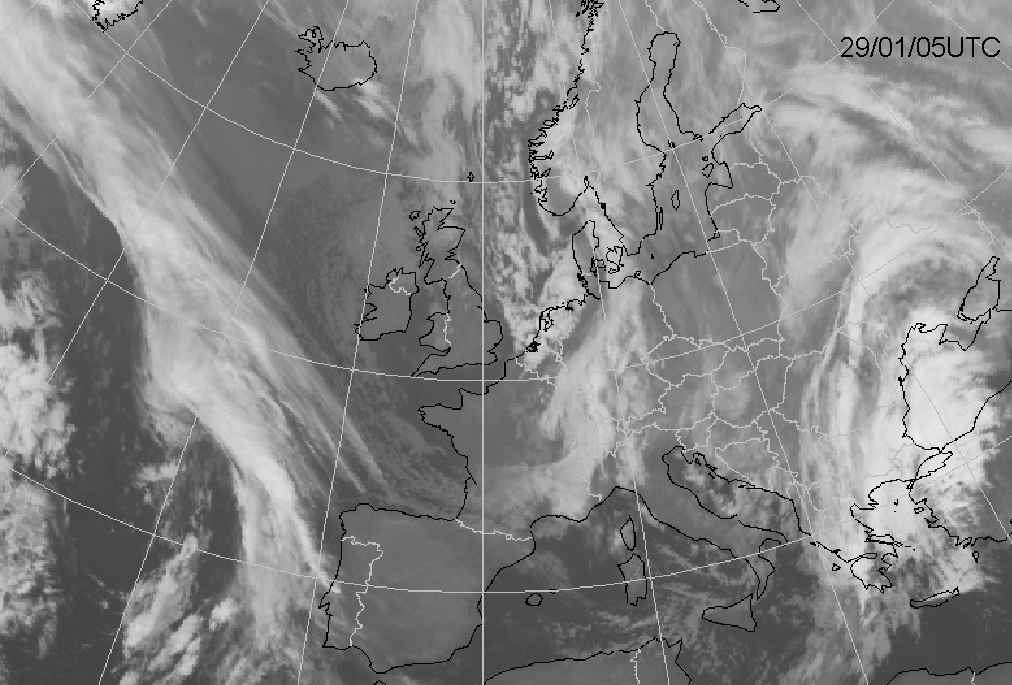
29 January 2004/06.00 UTC - Meteosat IR image
|
|
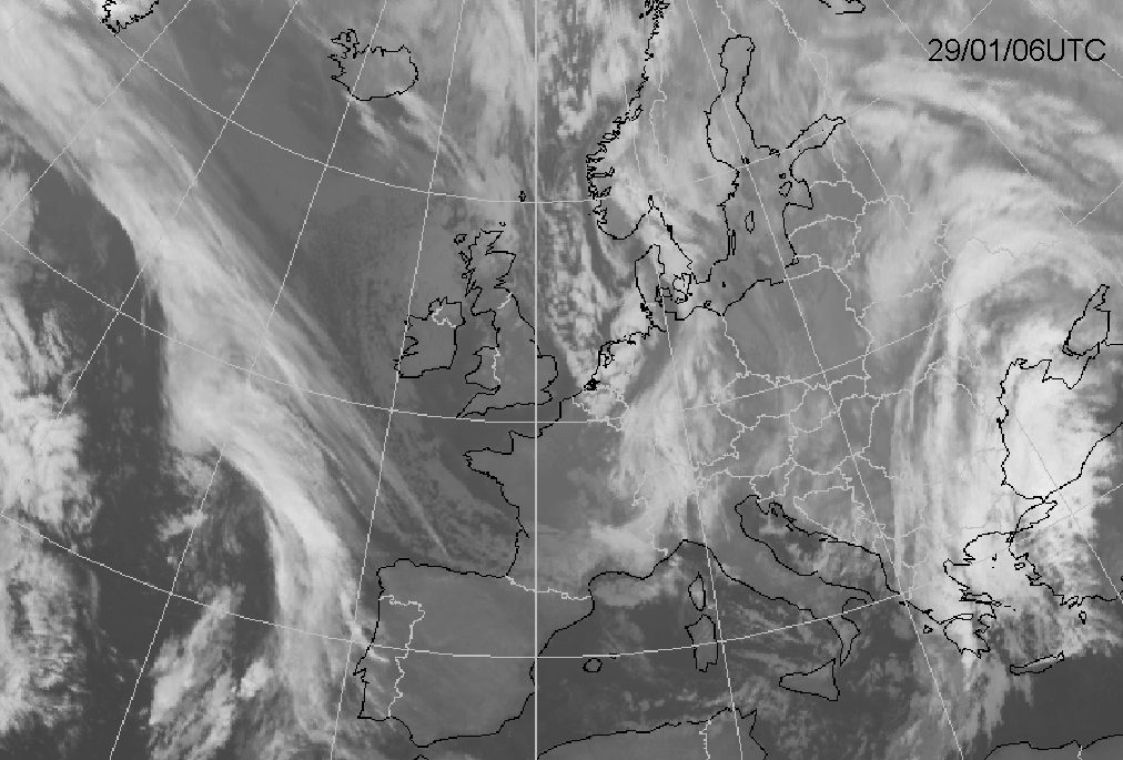
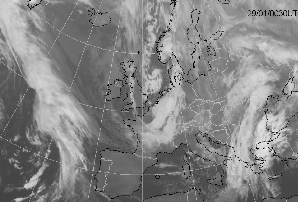
Above the North Sea the Polar Low turns in the direction of German Bight and moves into northern Germany and the northeastern parts of The
Netherlands (29 January 06.00 UTC). The spiral structure disappears quickly and the Polar Low decays.
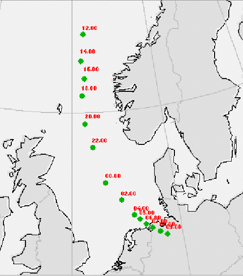
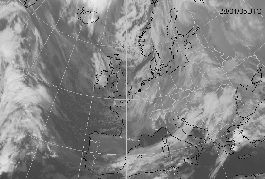
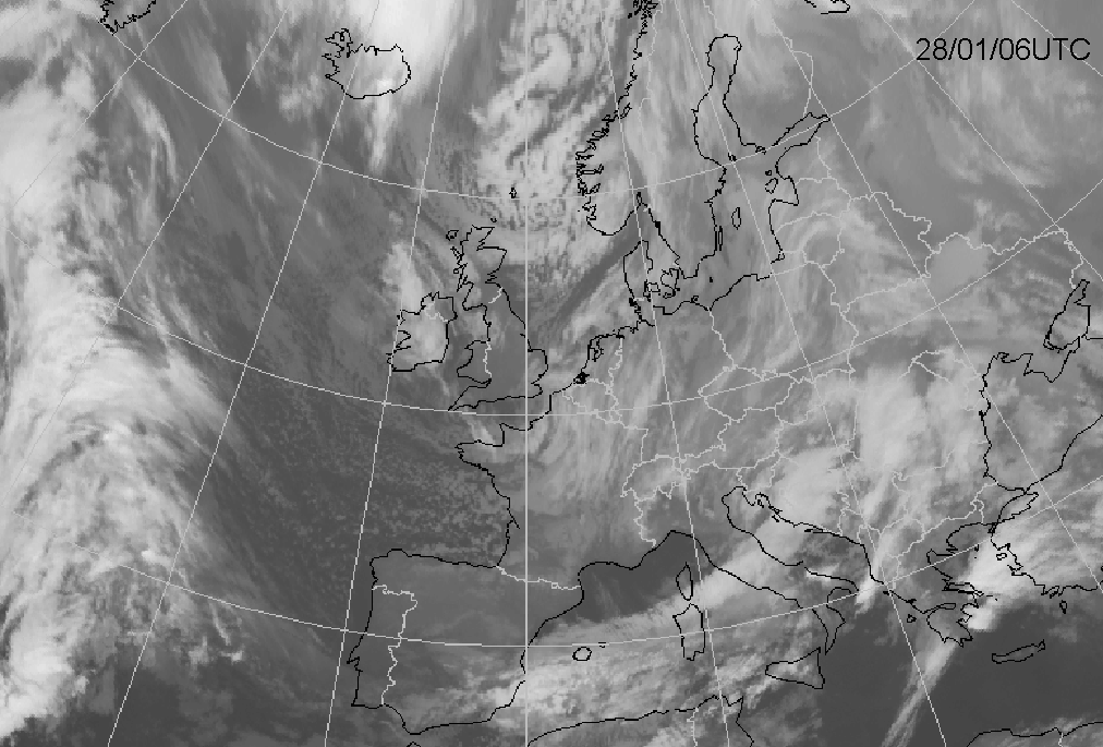
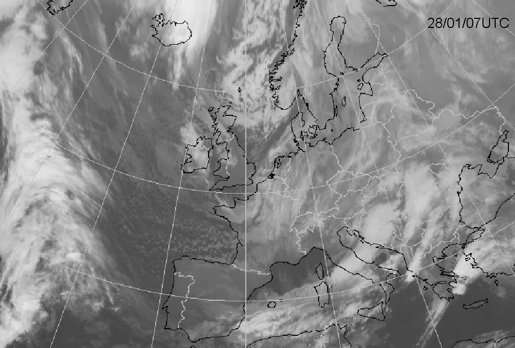
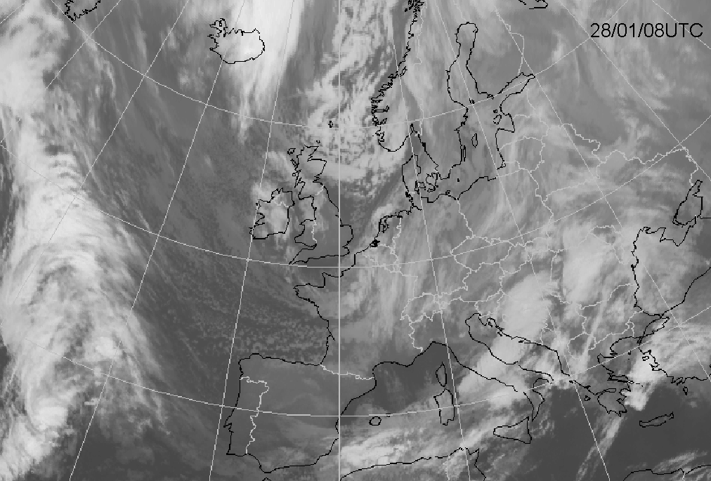
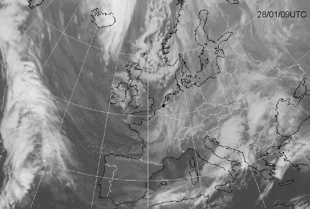
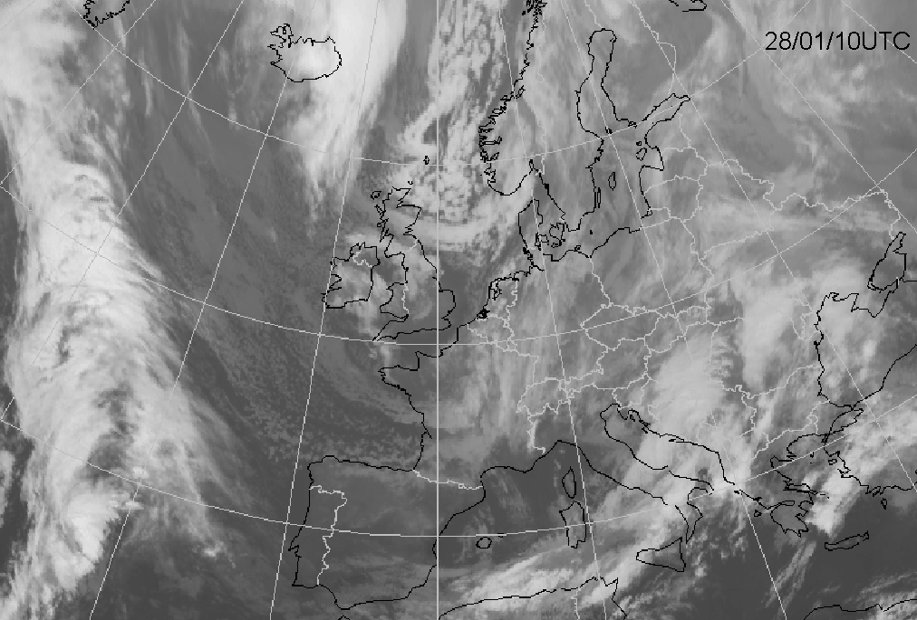
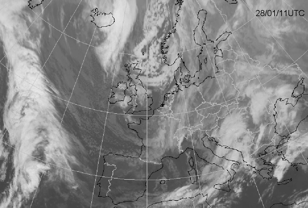
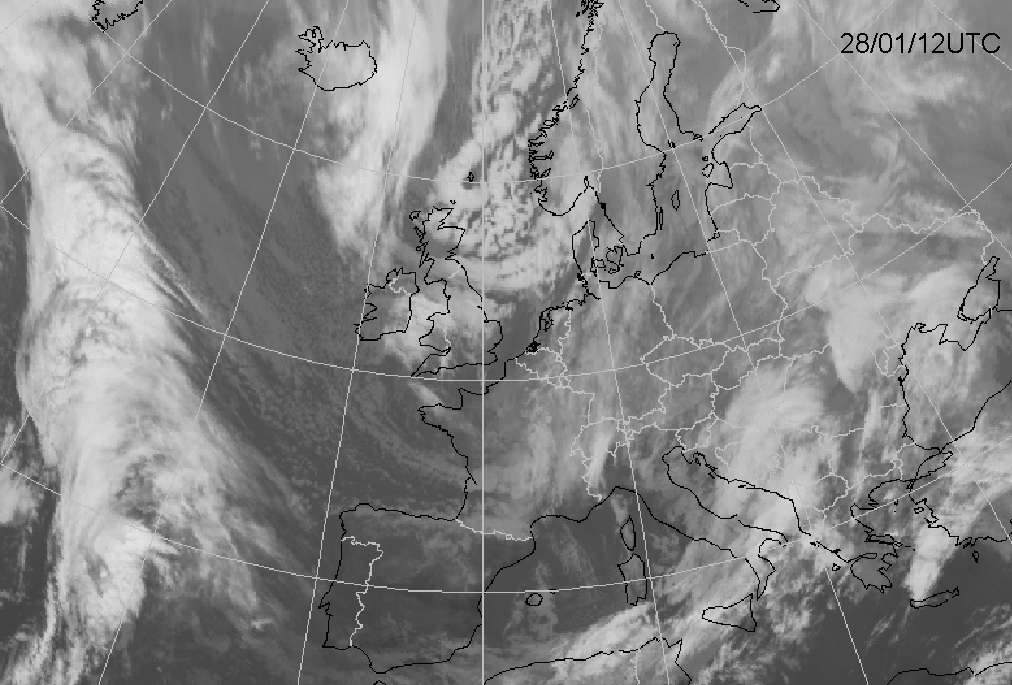
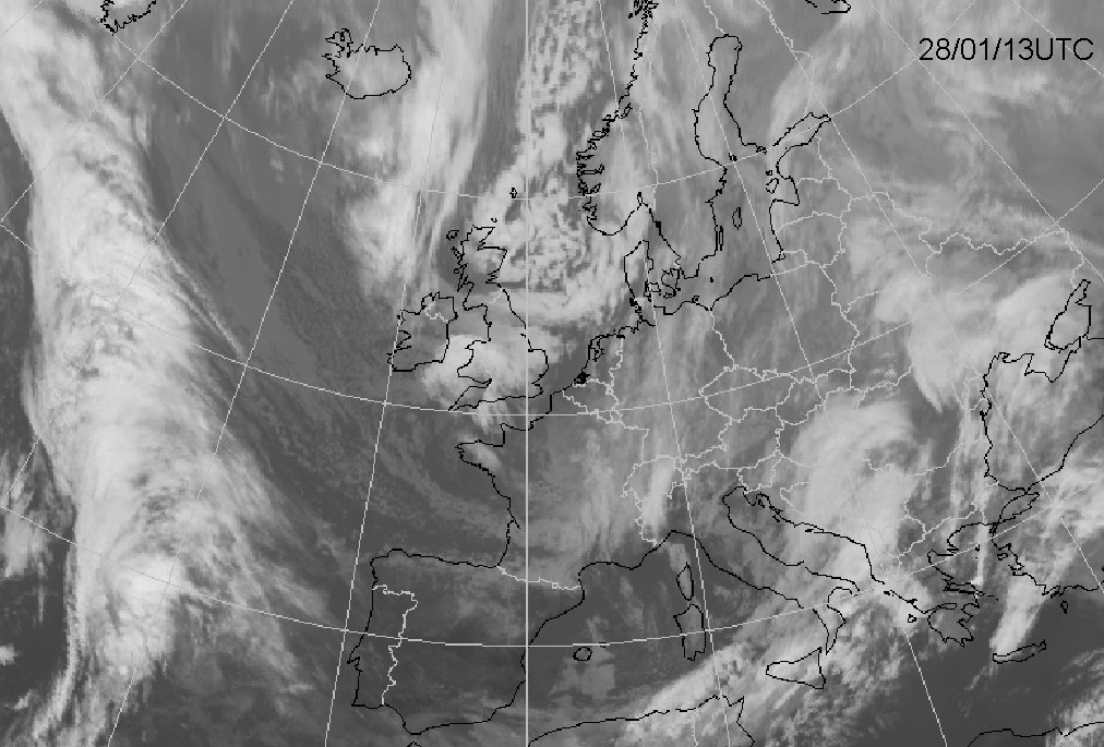
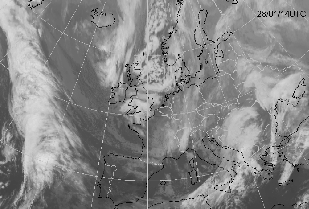
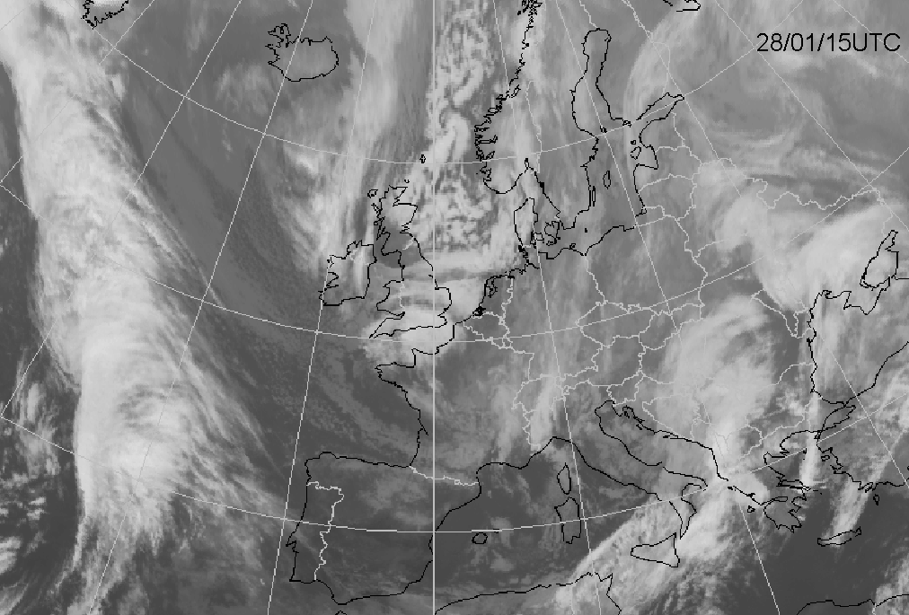
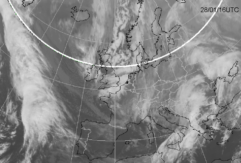
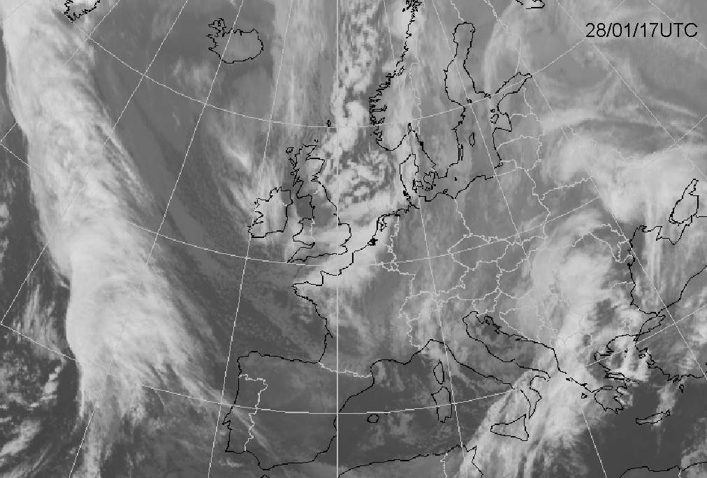
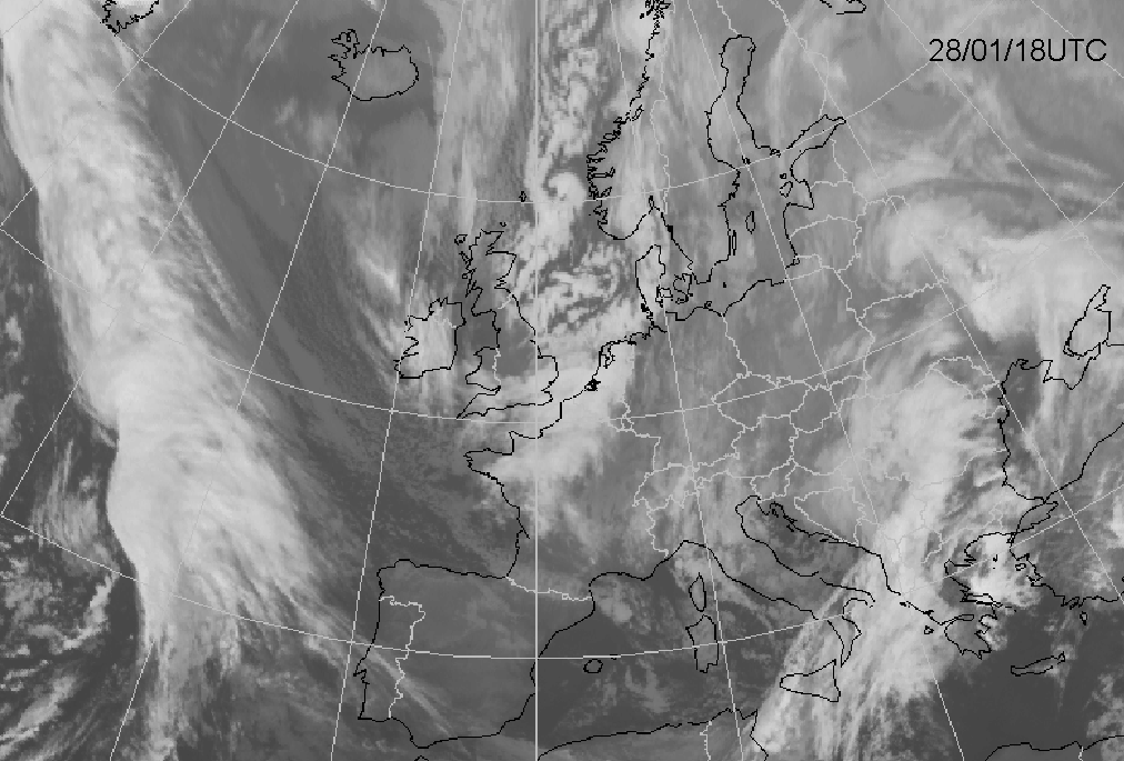
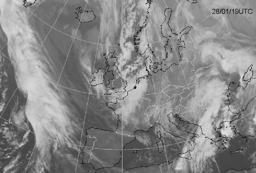
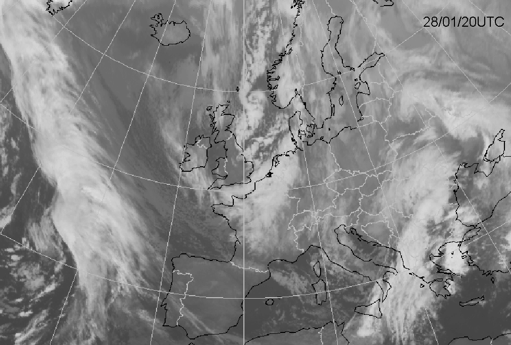
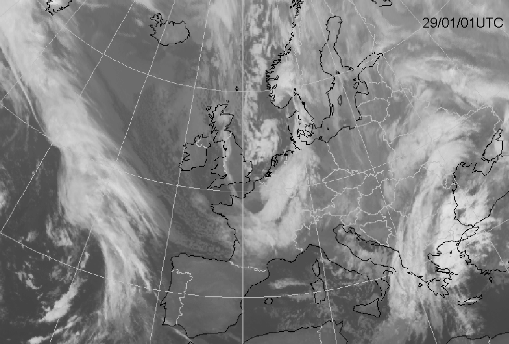
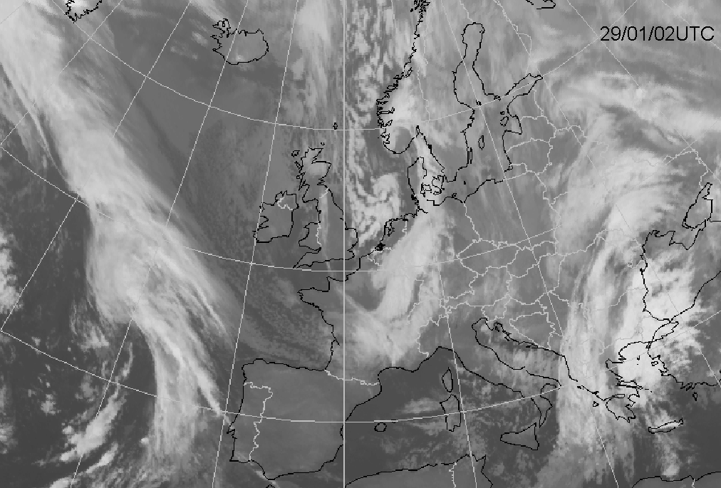
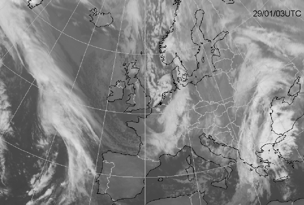
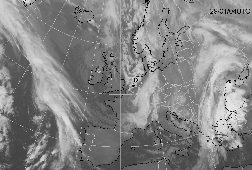
The position of the Polar Low is followed using satellite images, radar pictures and surface observations. The position of the Polar Low over
time is shown in the figures beneath (29 January 12.00 UTC - 30 January 09.00 UTC in steps of two hours, and from 04.00 UTC in steps of one
hour). The Polar Low moves in a straight line southwards and then turns over the North Sea, following the general flow. The Polar Low moves
with a constant speed, from northwest to southeast, over the northeastern parts of The Netherlands. The core of the low makes landfall around
06.00 UTC in northwest Germany and the central pressure drops to 986 hPa. From the moment the Polar Low reaches land, the pressure slowly
starts to rise and the low fills. With the approach of the polar low the wind starts to veer from southwest to northwest and increases in
speed. In the northern coastal areas the northwesterly wind reaches force 8/9. The highest mean hourly wind speed is force 8. Over land the
windspeed is generally force 4 to 6.
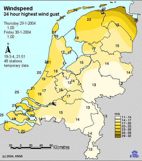
Polar Lows are often accompanied by strong wind gusts. The figure below shows an overview of the highest reported wind gust during a period of
24 hours on 29 January. The highest wind gust was reported in Nieuw-Beerta (eastern part of Groningen): 28 m/s (force 10).
|
Position of the Polar Low from 28 January to 29 January
|
29 January 2004 - 24 hours maximum wind gusts
|
|
|
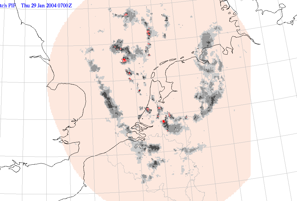
Surface isobar analysis shows that a meso scale low-pressure area has developed. Because there is a lack of observations northward of the polar low it cannot be stated with full 100% certainty. The lowest measured pressure in the centre is 986 hPa. The output of the Hirlam model at 06.00 UTC does not show a separate low-pressure area at the surface, but a sharp trough. The model pressure at the position of the Polar Low is overestimated by approximately 6 hPa. The consequence of this overestimation has a significant impact on the wind forecast. The lack of such a strong pressure drop over a short period of time and at a small horizontal scale causes a significant underestimation of the wind. Wind speed and wind gusts turned out to be much higher than forecasted by the model.
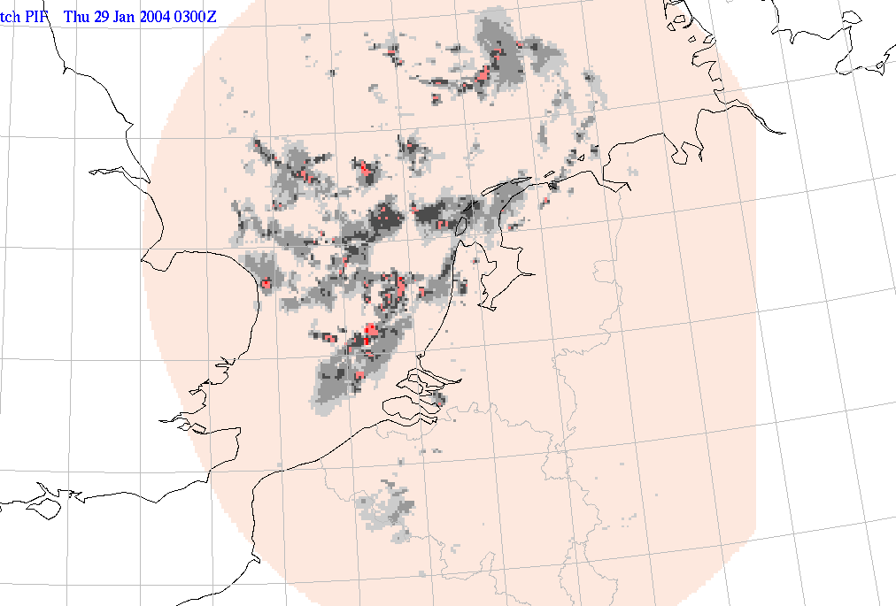
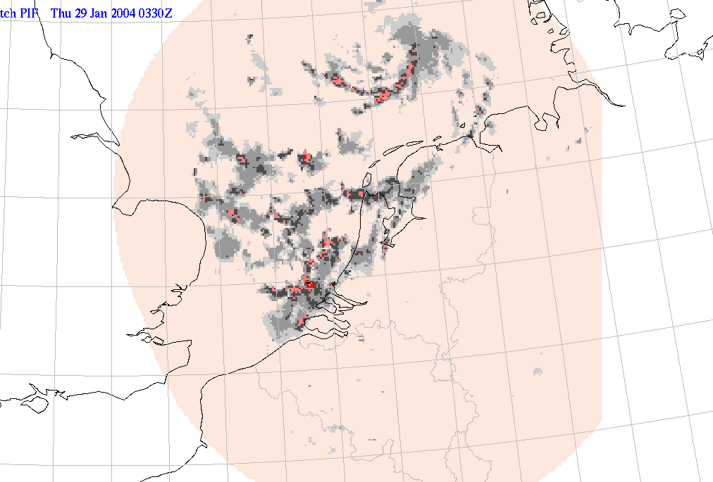
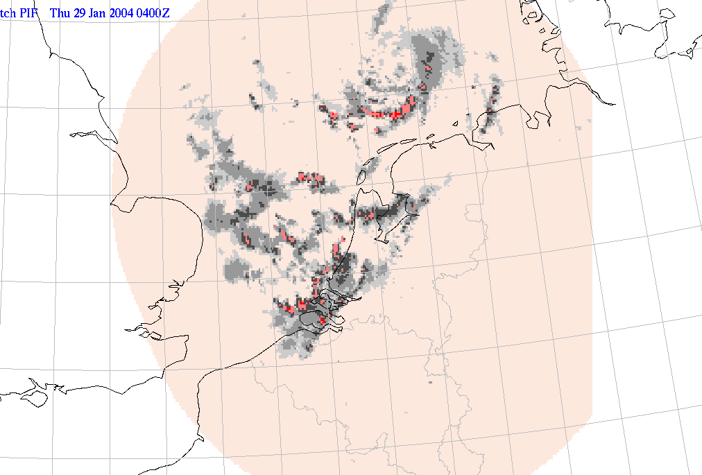
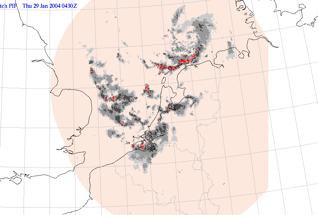
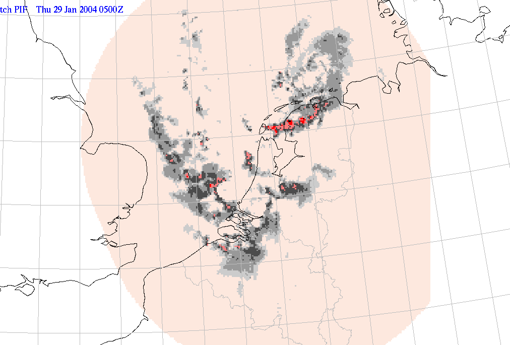
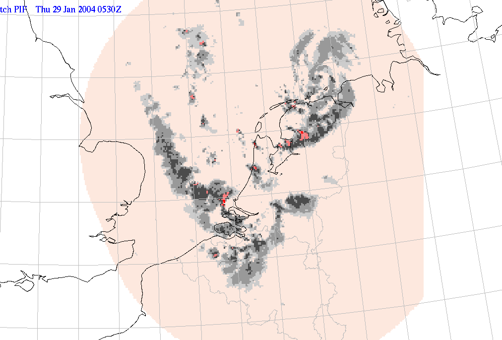
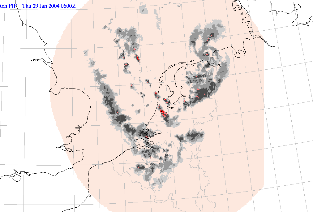
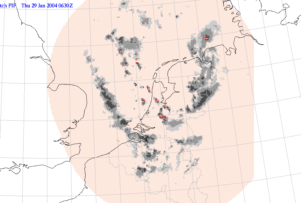
The vortex can also be detected clearly on radar pictures. The intensity of the low decreases rapidly and the structure disappears after landfall (see pictures below). Showers are observed throughout the rest of the day from the North Sea area, but the number and intensity of the showers gradually declines.
|
29 January 2004/03.00 UTC - Radar image; 29/03.00 - 29/07.00 UTC half-hourly image Loop
|
29 January 2004/07.00 UTC - Radar image
|
|
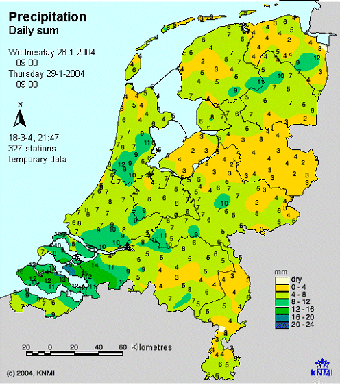
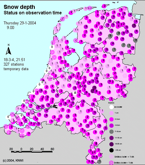
The northern part of The Netherlands is, to a large extent, free of snow on 28 January 09.00. There is only some snow in coastal areas, but the snow depth doesnt exceed one centimetre. On Wednesday 28 January, during late afternoon and early evening (from about 17.00), an extensive area of precipitation moves eastwards over northern Netherlands. The precipitation starts to fall as rain, but quickly turns to snow. The temperatures which is +1 degree Celsius at the end of the afternoon, falls to -1 degree by the beginning of the evening. The wind veers from southwest to northwest. From 22.00 on it is dry and, for the greater part, cloud free. The temperature reaches its minimum of -5° Celsius at 02.00hr. From this moment on the temperature slowly increases, due to the veering of the wind in a direction from which the air is brought down over sea. The freezing point isotherm reaches the coastal areas at 04.00, but then slowly pulls back in a southeastwards direction. At 09.00hr the temperature in the eastern parts of the northeastern provinces of Groningen and Drenthe is still around freezing level. At 05.00 the first snow showers of the Polar Low move into the northern parts of the Netherlands. The heaviest showers are located south of the low where especially in the northern province of Friesland, there is heavy showers and thunderstorms. The northwestern parts of Germany also report thunderstorms. By landfall the precipitation intensity is decreasing. The last snow showers leave the Netherlands around 08.00hr. The snowfall caused by the Polar Low reached the province of Overijssel, south of Drenthe. Most stations in northern Netherlands report 4 to 7 millimetre of precipitation (ending on 29 January at 09.00). High 24 hours precipitation amounts can be found from southeast-Friesland towards Drenthe and southeast-Groningen (see left figure below). The figure below on the right shows the snow depth at 29 January 09.00. It clearly shows that the coastal zones of Friesland and Overijssel have less snow than Drenthe and Groningen. Higher temperatures is the cause of this, with melting snow, but also the direction of movement and the decreasing intensity of the showers. The largest part of southeast-Friesland, Drenthe and southeast-Groningen report a snow depth of at least 5 cm. Winschoten (east-Groningen) has the highest snow depth: 11 cm. As mentioned before the Polar Low is not the only cause of this snow, but it also came from the Arctic Front that passed over the region the previous evening.
|
29 January 2004/09.00 UTC - Observed sum of 24 hours precipitation
|
29 January 2004/09.00 UTC - Observed snow depths
|
|
|
Analysis for 27 January 2004
27 January 2004 06.00 UTC
|
27 January 2004/06.00 UTC - Meteosat IR image; cyan: height contours 500 hPa, magenta: height contours 1000 hPa
|
|
|
The outbreak of arctic air becomes visible between a low-pressure area located to the west of the Norwegian west coast and a high-pressure area west of Iceland.
|
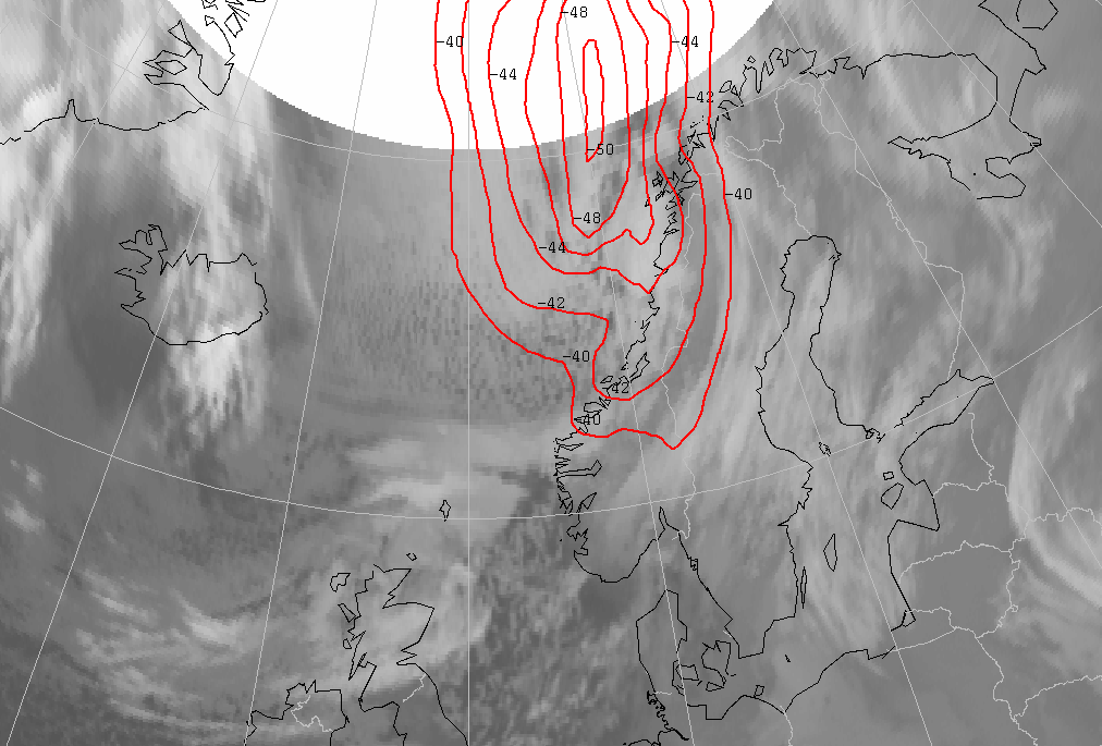
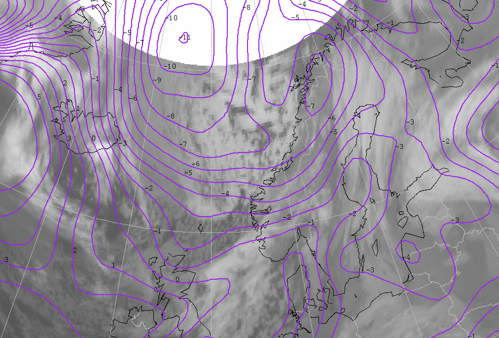
27 January 2004/06.00 UTC - Meteosat IR image; red: temperature 500 hPa
|
|
|
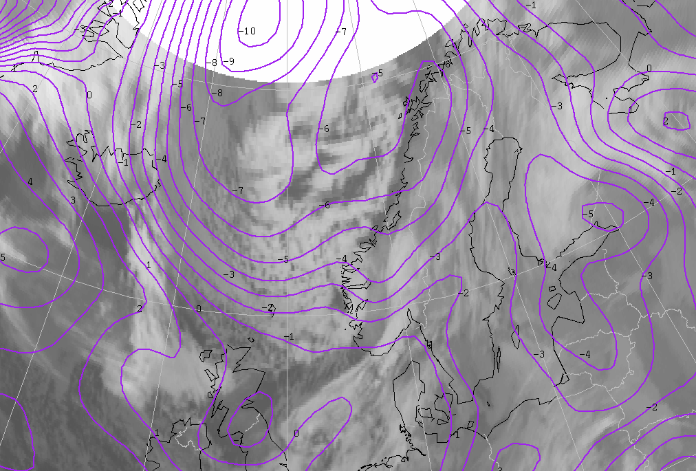
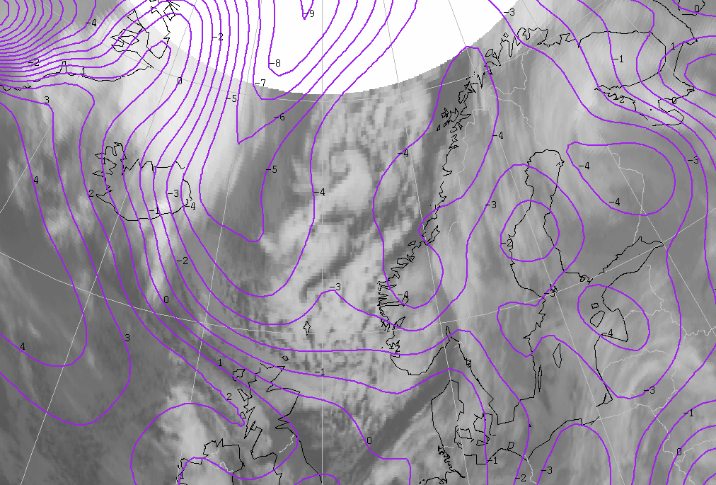
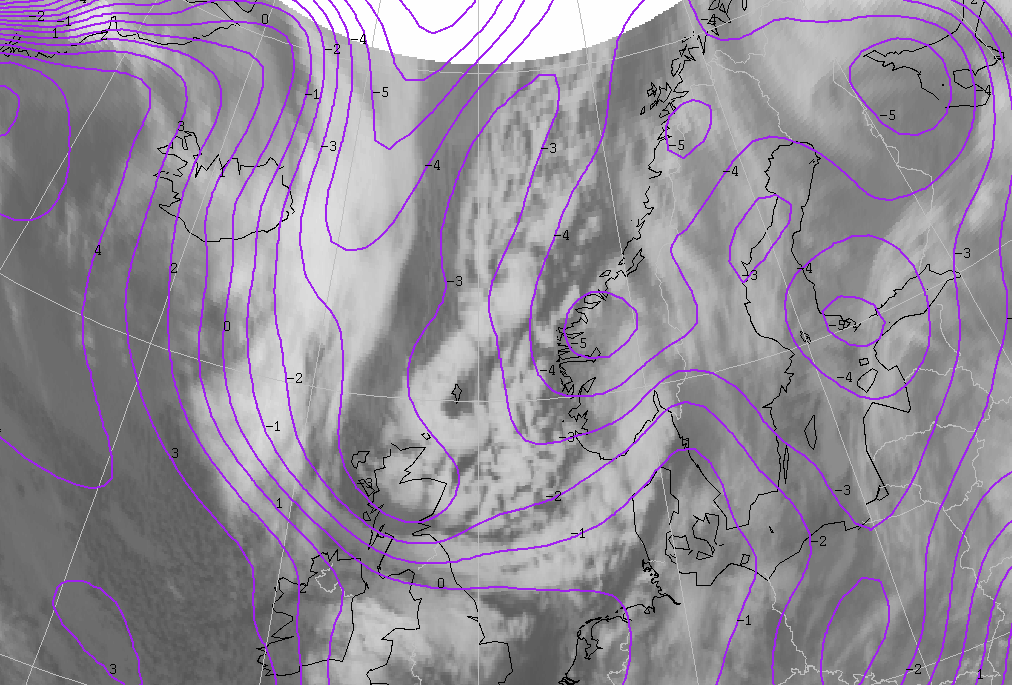
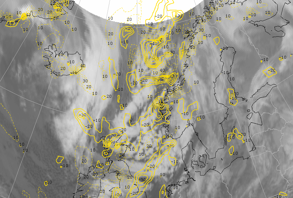
A key parameter for a Polar Low is the temperature at 500 hPa. This temperature has to be -40° Celsius or lower. This condition is fulfilled over a large area in which the lowest temperature is even -50° Celsius.
27 January 2004 18.00 UTC
|
27 January 2004/18.00 UTC - Meteosat IR image; cyan: height contours 500 hPa, magenta: height contours 1000 hPa
|
|
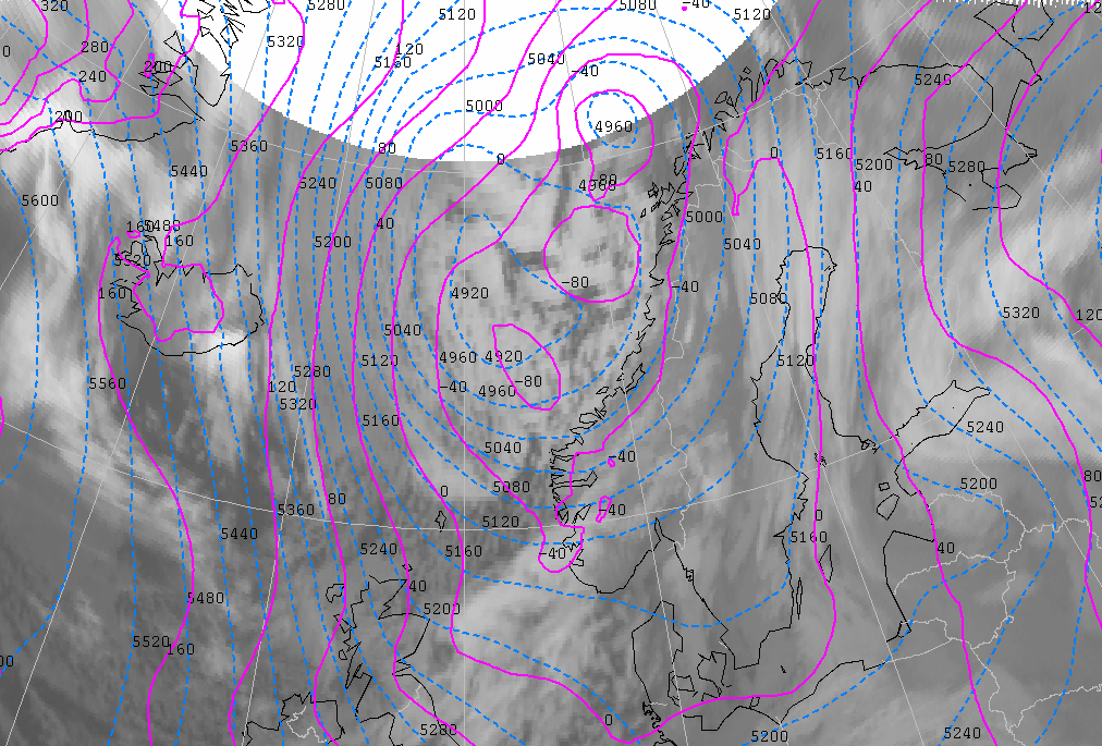
|
At this time, the low-pressure area west of the Norwegian coast has two separate cores with a central pressure around 990 hPa. The most northern low-level trough is situated ahead of a trough at 500 hPa. The first clouds begin to merge at this time and the tops are becoming brighter, which means they are becoming colder. This is all a result of strong upward motion. The first trough is situated from Northern Ireland towards southern Norway; again an upper level trough at 500 hPa follows this low level trough. This upper trough is preceded by thin, high cloudiness.
|
27 January 2004/18.00 UTC - Meteosat IR image; cyan: height contours 500 hPa, green: PVA 500 hPa
|
|
|
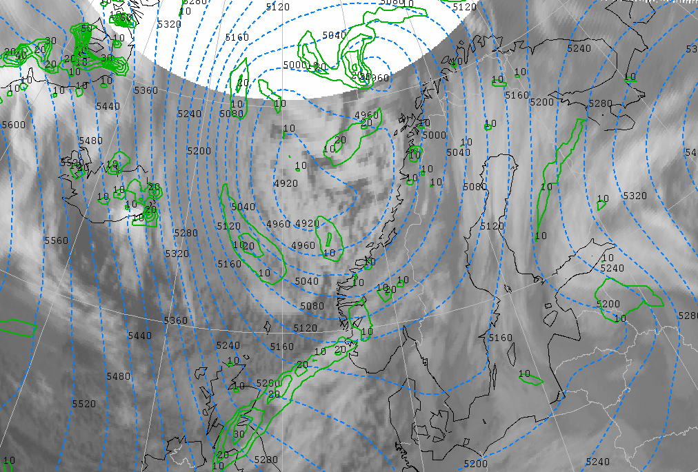
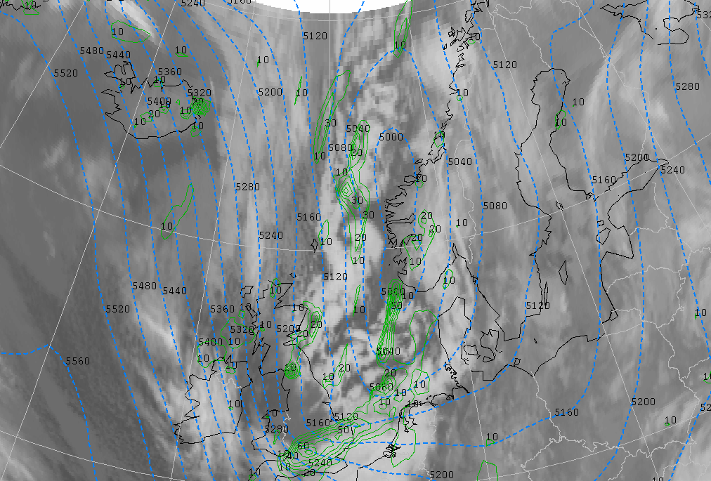
There are different areas of significant positive vorticity advection (PVA) above the clustered cloudiness west of the Norwegian coast. An important maximum of PVA is out of the range of the satellite, as it is too far north. An area of PVA coincides with the rear of a patch of cloudiness on the trough at the northern part of the North Sea. This area of PVA precedes an upper level trough at 500 hPa.
|
27 January 2004/18.00 UTC - Meteosat IR image; purple: ThetaW 850 hPa
|
|
|
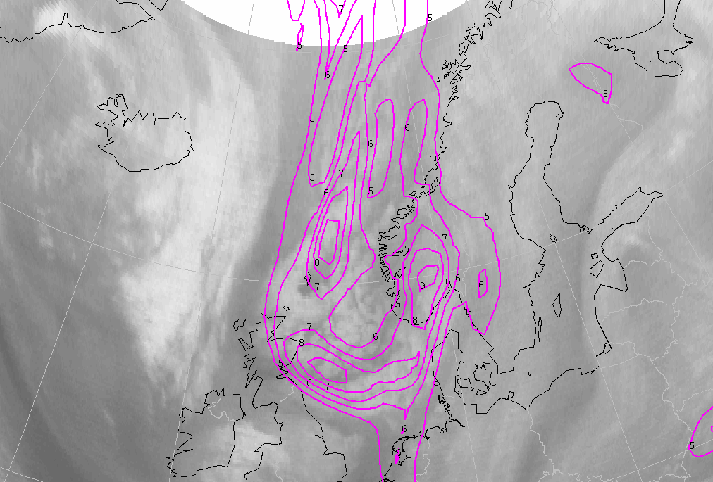
There is also a baroclinic zone, recognizable through a strong ThetaW gradient from north to south. Polar Lows often develop in a baroclinic zone such as this, and is probably the reason for the development and clustering of heavy showers in this area.
|
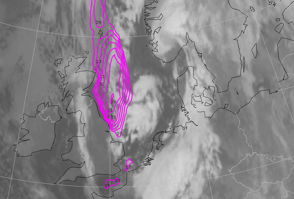
27 January 2004/18.00 UTC - Meteosat IR image; magenta: surface isotachs in kts
|
|
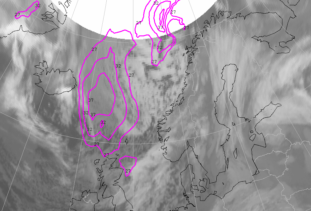
|
Another characteristic parameter of Polar Lows is the wind speed. Polar lows are often accompanied by strong winds. At least 27 knots or 14 m/s is the required condition for identifying a Polar Low. The areas east of Iceland and northwest of Norway fulfil this condition. A small vortex will develop later for a short time at the position of the wind maximum east of Scotland. This vortex does not fulfill all the key parameter conditions for Polar Lows, but the wind speed, development in a low level trough followed by an upper level trough, are required conditions. Temperature at 500 hPa is about -35° Celsius and that is too warm for Polar Lows. This vortex does not evolve spectacularly over time.
Analysis for 28 January 2004
28 January 2004 00.00 UTC
|
28 January 2004/00.00 UTC - Meteosat IR image; cyan: height contours 500 hPa, magenta: height contours 1000 hPa
|
|
|
There are now three separate low-pressure centres. The lowest pressure is about 987 hPa. On the left side of the cloudiness we see several small vortices that subsequently grow further into two polar lows. The low-level trough is difficult to recognize on the picture above, but it lies ahead of a clearly visible upper-level trough at 500 hPa. The small vortex that developed in the band of cloudiness associated with the trough from Norway to England is now visible above the North Sea. The trough is followed by a sharp-bordered stroke of spells.
|
28 January 2004/00.00 UTC - Meteosat IR image; purple: ThetaW 850 hPa
|
|
|
The position of the arctic front is clearly visible on the picture above. The strong gradient in ΘW at 850 hPa lies near the front of the cloudiness.
|
28 January 2004/00.00 UTC - Meteosat WV image; magenta: potential vorticity 303K
|
|
|
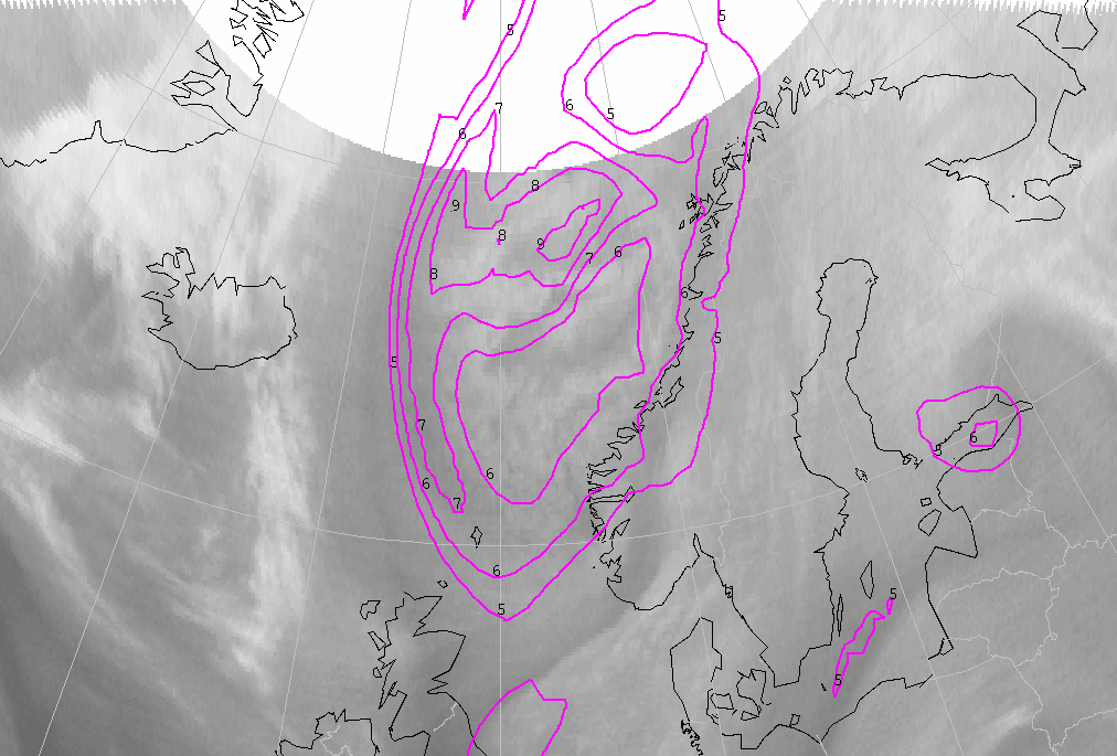
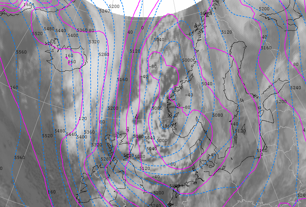
In the developing phase of a Polar Low a maximum in potential vorticity (PV) is often found upstream of the low. In this case there is a very large area of PV (higher than 5 units) in the upper part of the troposphere (at 303K) at a position corresponding to the area of cloudiness. A maximum of 8 PVU is found northwards of the most northern vortex.
28 January 2004 06.00 UTC
|
28 January 2004/06.00 UTC - Meteosat IR image; cyan: height contours 500 hPa, magenta: height contours 1000 hPa
|
|
|
The steering low-pressure area has moved further southwards, and the low-pressure area did not deepen further. The small vortex above the North Sea has moved southeastwards and lies near the Dutch coast. It can just be seen on the infrared satellite pictures. The accompanying band of cloudiness where the vortex developed, dissolves quickly and eventually largely disappears.
|
28 January 2004/06.00 UTC - Meteosat IR image; magenta: ThetaW 850 hPa
|
|
|
The strong gradient in the ΘW at 850 hPa decreases as the Arctic Front moves further south.
A Polar Low is situated north of the Shetland Islands (62N/02W) and a second Polar Low vortex can be seen at 67N/02E, between Iceland and
Norway.
28 January 2004 12.00 UTC
|
28 January 2004/12.00 UTC - Meteosat IR image; cyan: height contours 500 hPa, magenta: height contours 1000 hPa
|
|
|
In the meantime, the clouds of the Arctic Front have moved southwards into the North Sea and the centre of the main depression is situated over southern Norway. The arctic front coincides with the low-level trough and is followed by an upper-level trough at 500 hPa. The Arctic Front, which lies from Norway, the British Islands towards Iceland, is clearly visible through its cloudiness, except for the part above the British Isles (see also image of ΘW at 850 hPa below).
|
28 January 2004/12.00 UTC - Meteosat IR image magenta: ThetaW 850 hPa
|
|
|
The first Polar Low has passed the Shetlands and is heading for Scotland. It seems that the second Polar Low further north disappears between 08.00 and 11.00 UTC. But from 12.00 UTC, the vortex clearly exists once again.
|
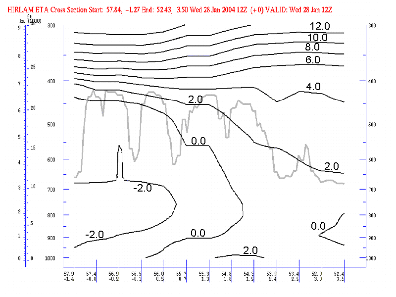
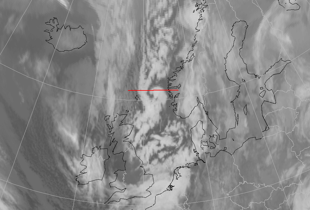
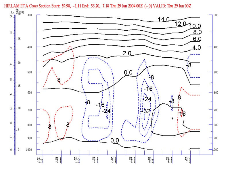
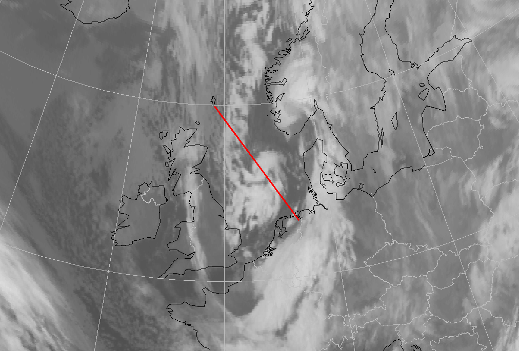
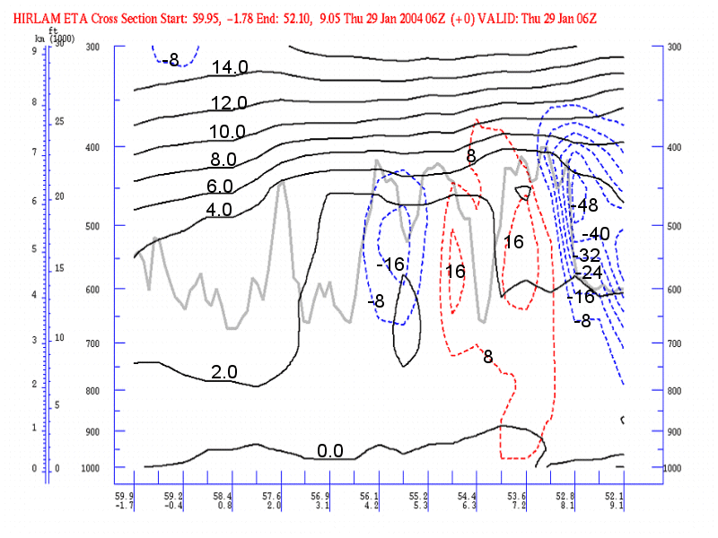
28 January 2004/12.00 UTC - Vertical cross section; black: isentropes (ThetaW), grey: satellite signal
|
|
|
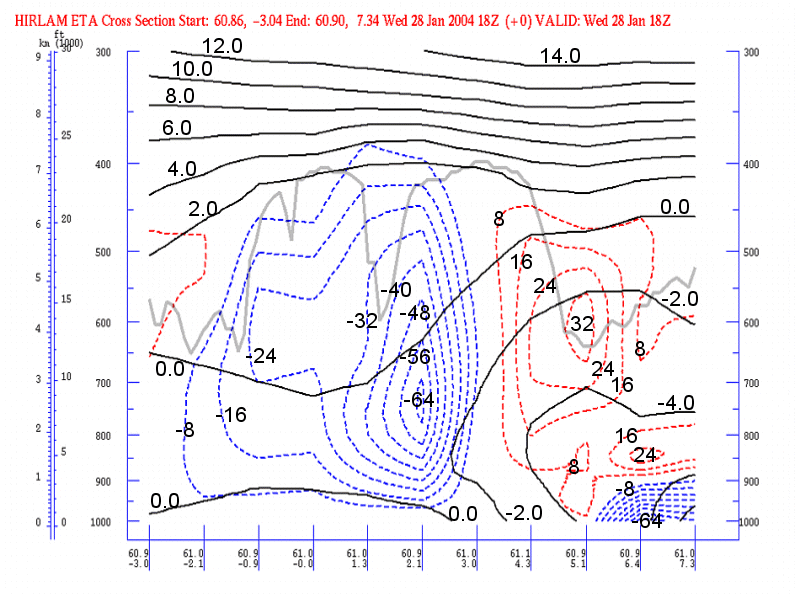
This vertical cross section is made perpendicular to the arctic front, from northwest to southeast. The arctic front is easily recognized in the bending of the isentropes. The corresponding satellite signal clearly reveals the position of the clouds. Higher values of satellite signal result from a whiter colour and higher cloud tops. The Arctic Front is visible up to about 450 hPa.
|
28 January 2004/12.00 UTC - Meteosat IR image; yellow: vertical motion (omega) 850 hPa
|
|
|
Negative omega values (ascending air) lie over the cloud areas of the two Polar Lows. The Polar Low close to Scotland is surrounded by positive values of omega. The second Polar Low has the strongest negative values and therefore the strongest upward motion.
|
28 January 2004/12.00 UTC - Meteosat WV image; magenta: potential vorticity 303K
|
|
|
The area with PV-values exceeding 5 units at the level of 303 Kelvin covers approximately the whole area west of the Norwegian coast and the North Sea. A maximum of 9 units (or PVU) can be found between the two Polar Lows. This value decreases until 18.00 UTC on 29 January 2004, but at the position of the northern Polar Low it remains above 5 PVU.
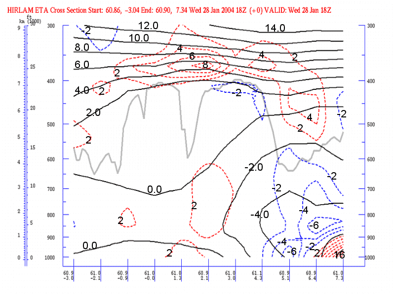
28 January 2004 18.00 UTC
|
28 January 2004/18.00 UTC - Meteosat IR image; cyan: height contours 500 hPa, green: positive vorticity advection (PVA) 500 hPa
|
|
|
The centre of the steering depression has moved a bit southwards and the surface pressure at the centre is unchanged. The Polar Low near Scotland has moved towards the North Sea but has lost its identity, while the second, now between Norway and the Shetland Isles has developed into a pronounced vortex and is moving further southwards. This vortex lies in front of a shallow upper trough with an extended are of PVA. Areas with positive vorticity values up to 30 units can be found over the North Sea near the cloud clusters of the former Polar Low.
|
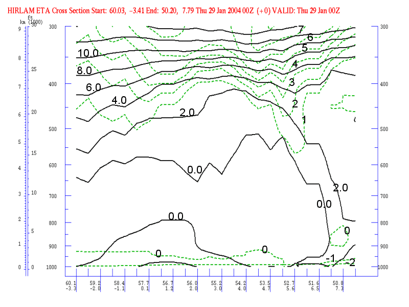
28 January 2004/18.00 UTC - Vertical cross section; black: isentropes (ThetaW), red: vertical motion (omega) - downward motion, blue:
vertical motion (omega) - upward motion, grey: satellite signal
|
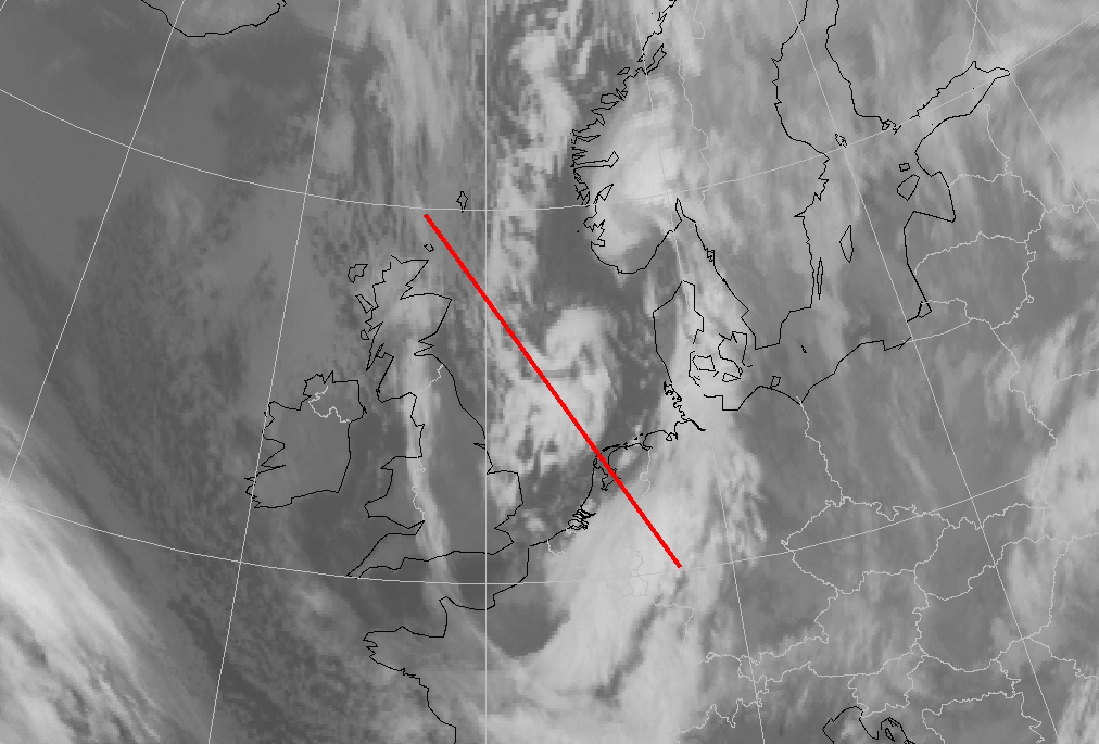
28 January 2004/18.00 UTC - Meteosat IR image; position of vertical cross section indicated
|
|
|
The centre of the Polar Low can be found at approximately 61N/2E in this vertical cross section from west (61N/3W) to east (61N/7E). The vertical cross section shows omega, ΘW and the satellite signal. The satellite signal clearly reveals the nearly cloudless area west of the polar low (low satellite signal value), then a band of cloudiness (high value), followed by miscellaneous clouds round the core of the Polar Low and, finally, the cloudless area west of the Norwegian coast. Strong ascent characterizes the area of the centre (negative values of omega).
|
28 January 2004/18.00 UTC - Vertical cross section; black: isentropes (ThetaW), blue: temperature advection - CA, red: temperature
advection - WA, grey: satellite signal
|
|
|
The vertical cross section above shows the advection of temperature, ΘW and the satellite signal. At the position of the Polar Low (61N/2E) warm air advection is found in the lower levels (up to 600 hPa) and cold advection above that level. This combination will lead to a stronger temperature contrast and destabilisation of the air mass, with a possible, subsequent intensification of the Polar Low.
Analysis for 29 January 2004
29 January 2004 00.00 UTC
|
29 January 2004/00.00 UTC - Meteosat IR image; cyan: height contours 500 hPa, magenta: height contours 1000 hPa
|
|
|
According to the model, the centre of the main depression lies in the Skagerak area and the air flow over the North Sea slowly starts to back to a more northwesterly direction. This causes the Polar Low vortex to turn towards the northeastern parts of the German Bight. The vortex still lies ahead of a shallow upper trough and very close to a surface trough in the model fields.
|
29 January 2004/00.00 UTC - Meteosat IR image; magenta: surface isotachs in knots
|
|
|
Maximum wind speed at this time is 40 knots. This maximum can be found along the west side of the Polar Low, the area where the gradient of isobars is situated. Stations along the east coast of Britain report wind gusts up to 48 knots.
|
29 January 2004/00.00 UTC - Vertical cross section; black: isentropes (ThetaW), red: vertical motion (omega) - downward motion, blue:
vertical motion (omega) - upward motion, grey: satellite signal
|
29 January 2004/00.00 UTC - Meteosat IR image; position of vertical cross section indicated
|
|
|
The vertical cross section above shows isolines of ΘW and omega. The vertical cross section has been made in the direction of movement of the Polar Low, and the centre of the vortex lies over the North Sea at approximately 57N/03E. Strong values of negative omega (ascending air) can be found at the centre of the Polar Low. At 700 hPa there is a small area with slightly positive values of omega (not visible in vertical cross section) between the two maxima, that can be explained by the descending air in the centre of a fully grown Polar Low.
|
29 January 2004/00.00 UTC - Vertical cross section;black: isentropes (ThetaW), blue: temperature advection - CA, red: temperature advection - WA, grey: satellite signal
|
29 January 2004/00.00 UTC - Meteosat IR image; position of vertical cross section indicated
|
|
|
This vertical cross section shows the isentropes of ΘW and the potential vorticity. Two anomalies can be found in the potential vorticity. The one to the left side of the cross section is situated to the rear of the Polar Low (position of the centre: 57N/3E) and the one to the right of the cross section is located at the northern side of the Arctic Front.
29 January 2004 06.00 UTC
|
29 January 2004/06.00 UTC - Meteosat IR image; cyan: height contours 500 hPa, magenta: height contours 1000 hPa
|
|
|
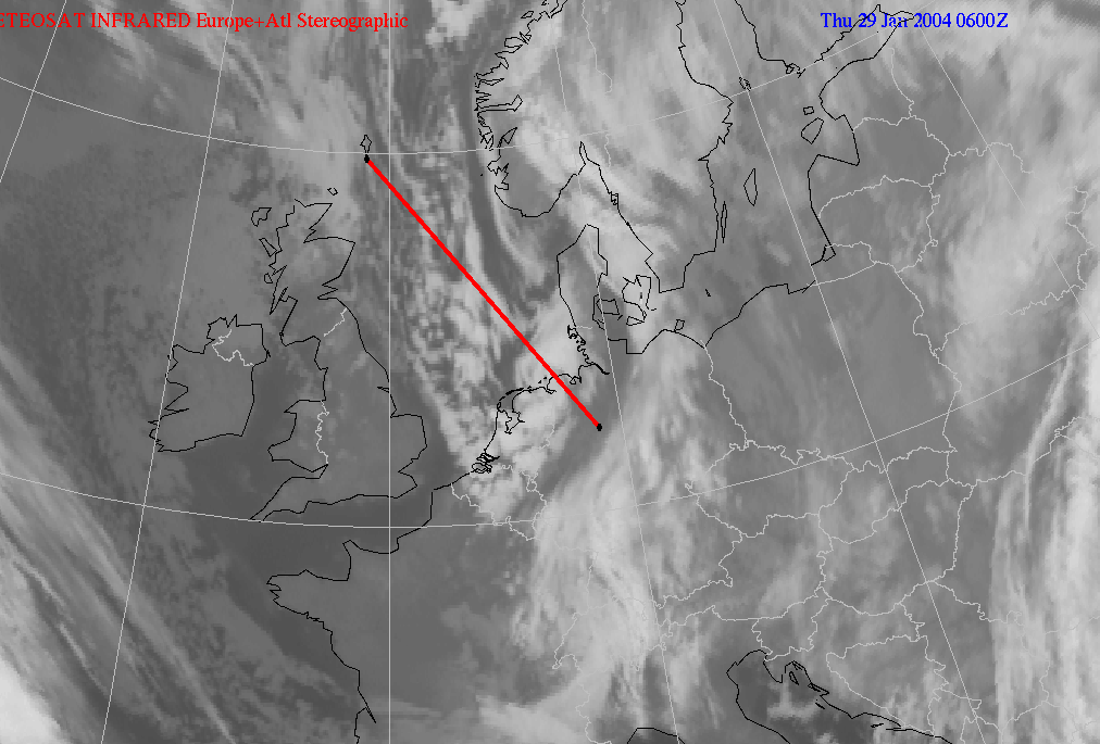
The centre of the main depression has reached Denmark. The Polar Low made landfall just before 06.00 UTC and the vortex as such is not visible anymore in the infrared image. The Upper- and surface trough are (compared to the 00.00 UTC analysis) in the same relative position with the Polar Low. Clustered snow showers with strong wind gusts are moving towards the northeast coast of the Netherlands and the northwest coast of Germany. The showers get less intensive as they move over land. The radar pictures (see chapter "description of the synoptic situation") still show the vortex structure of the low. The disappearance of the structure, and the decreasing intensity of the Polar Low starts almost directly after landfall.
|
29 January 2004/06.00 UTC - Vertical cross section; black: isentropes (ThetaW), red: vorticity advection - NVA, blue: vorticity advection - PVA, grey: satellite signal
|
29 January 2004/06.00 UTC - Meteosat IR image; position of vertical cross section indicated
|
|
|
Vertical cross section showing vorticity advection, isentropes and the satellite signal, in the direction of movement of the polar low (54N/07E). A maximum of positive vorticity advection lies at the position of the polar low. This maximum is more pronounced than at 6 and 12 hours earlier.
Hazards for the Public
The combination of the Polar Low, and the Arctic Front the evening before, caused many traffic problems. Not only did the northern parts of The Netherlands experience a lot of problems caused by snow and wind, so did other parts. The result was many traffic jams, delays at airports and accidents (and of course the usual snow fun!).
"One of the worst morning rush hours
29-1-04|NOS-News
The traffic stagnated on many roads this early morning. The cause of this chaos was the snowfall. There were reported 17 accidents on the motorways before 8.30, all without serious injuries. Except one, it was the worst morning rush ever with in total 68 tailbacks, which had a total length of 571 kilometres.
|
|
|

|
According to the KLP everybody adjusted quite well considering the bad circumstances. On the A24 close to the Schipholtunnel there was a traffic jam of 24 kilometres. Beside the snowfall, heavy wind gusts also caused problems in the coastal areas and the Wadden Islands. Number one in the traffic jam top 10 remains the 8th of February 1999. Snow and slipperiness caused traffic jam of in total 975 kilometres. Second was the 8th of February 1999 with 567 kilometres, but in less than 15 minutes the traffic jam of today conquered the second place.
Schiphol
The wind also harmed the air traffic. Flights at Schiphol generally had 30 minutes delay. The airport had around seven oclock in the morning two runways in use, one each for incoming and leaving airplanes. Normally Schiphol has two runways for incoming airplanes. During the night the weather was better than expected and caused therefore less trouble. The amount of accidents was the same as in a normal night. Yesterday the Royal Dutch Meteorological Institute (KNMI) warned with a so-called weather alert for huge problems during the night due to the snowfall. Especially the evening rush hour would endure a lot, but the showers arrived later than expected. In the meantime the KNMI has withdrawn the weather alert, because the circumstances have improved that well, according to a spokesman of the KNMI."
"Snow in the North: 130 accidents
30-1-04|Newspaper of the North
ASSEN/GRONINGEN - The heavy snowfall has led to over 90 accidents in the Province of Groningen and forty in the Province of Drenthe. The
majority took place on Thursday morning. Four people were taken to the hospital in Groningen. Thursday evening a cyclist in Drenthe sustained a
bone fracture.
The traffic in the north of Groningen suffered the most. Heavy wind gusts blew on Thursday morning a school bus off the road between Groningen
and Delfzijl. The bus slipped into a ditch. None of the children was injured and they could leave the bus through a broken window. The vehicle
was towed away.
Another five accidents happened at the same road. Lorries and cars slipped off the road after new heavy snowfall set in during noon. The
traffic was diverted for some time.
Between Groningen and Ten Boer drove a delivery van into the Damsterdiep. At the A7 aroused a traffic jam during the morning rush hour. The
police counted on this road sic accidents.
Near De Wijk got a car off the road A28 and landed in a ditch on Thursday evening. The driver was unharmed. Breakdown lorries were very busy
helping people who got off the road. Poort from Hoogkerk turned out twenty times, his colleague Dikkema from Garmerwolde also. 'We are always
busy with snowfall, but this time it was exceptional. Especially the slipped lorries gave us a lot of work.' Transport company Arriva
experienced little trouble of the snowfall. Busses were held up during the morning rush hour, but they could all drive their normal way."
"Wounded and stoppages due to snow
29-1-04|Leeuwarder Courant
LEEUWARDEN - The snowfall led this morning to long tailbacks during the morning rush hour. Especially drivers on the Waldwei were held up as a result of accidents and slipperiness. This morning there was only locally slipperiness on the roads. This led to long tailbacks. Traffic was hindered until after 9 oclock due to the bad weather conditions. On the A7 near exit Bolsward slipped a lorry into the verge. Two other trucks got stuck at the same place. Traffic to Bolsward was blocked for a time as a result."
"Winter merriment for Emmer Elephants
30-1-04|Newspaper of the North
EMMEN - Not only the children were happy with the snow on Thursday. The elephants in the Noorder Dierenpark enjoyed themselves also with the white powder, in spite of a slight fall."
|
|
|

|
Conclusions
Although this case was a very straightforward and clear example of a Polar Low which caused snow and wind problems over the North Sea and the
adjacent coastal areas, it can hardly be placed in the category of catastrophic cases. Therefore, the number of casualties and damage costs
were (luckily) low. The main reason being that Polar Lows are most active over sea and landfall of this low was during the very early morning,
over a relatively sparsely populated area. Moreover, it decayed rapidly in the following hours.
Detecting the initial stage of a Polar Low is rather difficult because of its tendency to develop above Arctic waters in an observation sparse
area. This is also the area where Meteosat images are of low quality due to the very low spatial resolution at that latitude. Polar satellite
images are more appropriate for this region.
In this case some early developments had taken place at very high latitudes and were, therefore, impossible to detect with Meteosat. The
required presence of characteristic meteorological parameters for development of such a phenomena was fulfilled over a large area in this case.
The investigated Polar Low, according to the Hirlam model, had not developed into a closed-isobar-low-pressure centre during the time period in
question, but surface observations contradict that. It has to be concluded that the model provided a very clear and useful signal but was not
able to completely describe these mesoscale phenomena.
In the initial stage the Polar Low was situated ahead of an isolated low-pressure area. In its later stages, the Hirlam model showed an upper
trough with a surface trough ahead of it, and the Polar Low vortex near to the surface trough. The combination of widespread convection, the
CISK mechanism (see introduction chapter) and PV as well as PVA were responsible for rapid fall in surface pressure and the development of a
vortex. The Hirlam model calculated the surface pressure in the centre of the Polar Low 6 hPa too high, at the time it made landfall.
Therefore, the forecast pressure gradient was also lower, which resulted in an underestimation of the wind speed by 3 to 6 m/s and, most
important, by an underestimation of the wind gusts by 8 to 15 m/s.
The amount of precipitation and its exact location were also not well shown in model output.