Table of Contents
- I. Initial state 14 June 1998/06.00 UTC: SatRep diagnosis
- Overview of satellite features and conceptual models
- 14 June/06.00 UTC: Frontal Diagnosis
- II.14 June 1998/06.00 UTC - 15 June 1998/06.00 UTC: The development of the front and detailed frontal diagnosis
- VSRF: 14 June 06.00 - 18.00 UTC
- 14 June/18.00 UTC: Frontal diagnosis
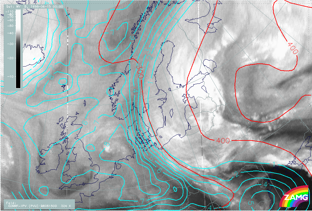
- 15 June/00.00 UTC: Frontal diagnosis
- 15 June/06.00 UTC: Frontal diagnosis
- VSRF: 15 June 06.00 - 18.00 UTC
- III. 15 June 1998/12.00 - 18.30 UTC: Unstable situation MCS
- Overview of satellite features at the synoptic scale during the observation period
- The observational part of MCS diagnosis - IR image sequence
- The synoptic environment part of MCS diagnosis - 15 June/12.00 and 18.00 UTC
- IV. Conclusions
Overview of satellite features and conceptual models
Introduction
This case study describes a weather episode, which is typical for eastern and northeastern Europe in summer.
The most common track for the low pressures reaching the Scandinavian and Baltic countries is from the Atlantic, from southwest or west. Yet these countries regularly experience cyclone passages either
- From the northwest (the Norwegian and the Arctic Sea). This area is a typical source for wintertime cyclones bringing snowstorms and heavy winds. (For example, see Case Study 29 - 30 January 1998 ).
- Or from south-southeast (the Balkan region and the Black Sea region). Cyclones generated over this area have characteristic features that are dealt within this case study. Among the meteorological community a common term "Black Sea low" (henceforth referred to as "BS lows" is used) even if the origins of the low pressure might not necessarily be exactly over the the Black Sea, but more generally over the southeastern Europe.
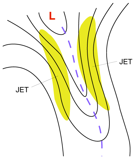
BS lows develop, when the upper trough over Central Europe has an extension to Black Sea and Anatolia peninsula, meanwhile a stationary surface anticyclone strengthens over Northern Russia and Fennoscandia. These cyclones have very meridional trajectories and in some cases are even bend westward in the Baltic region. A meridional jet stream can be found on both edges of the amplified upper level trough. The eastern jet stream is found on the upper troposphere.
|
Schematic image showing an extensive upper level trough and the jet streams on its both sides
|
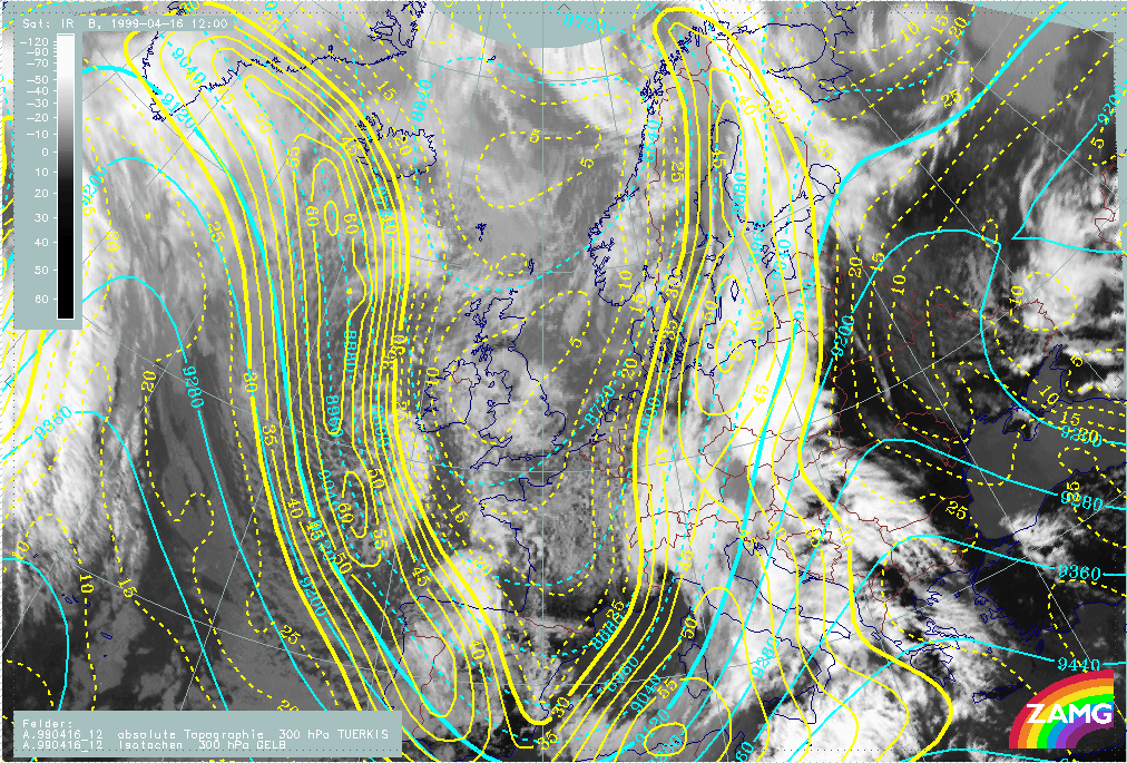
16 April 1998/12.00 UTC - Meteosat IR image; cyan: height contours 300 hPa, yellow: isotachs
|
|
|
BS lows can develop in two ways:
- They can be re-generated low pressures which travel from the Mediterranean countries northeastwards, possibly beginning already to fill up, but then starting to deepen again, taking a turn towards north or northeast. This type of development takes place most often in late summer and early autumn.
- Alternatively the low pressure can be formed along the (stationary) front which extends from southeast Europe towards north or northwest. This stationary front is located on the leading (eastern) side of a extensive upper level low, which may be either at its tear-off or cut-off stage. Sometimes this stationary front can be non-developing for days, with weak waves travelling along the front not deepening.
It has to be kept in mind, however, that the waves being "weak" does not mean that the accompanying weather would be weak. The stationary or semi-stationary front represents a distinct air-mass boundary with very distinct changes in temperature and wind and along which the accumulated precipitation amount due to prolonged rainfall can be very high.
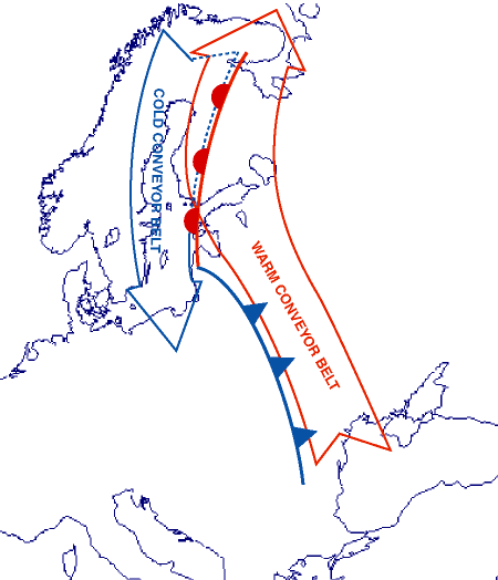
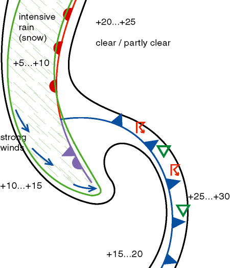
A typical configuration of main conveyor belts, surface fronts and accompanying weather is shown on the images below.
|
|
|
|
|
In Scandinavian area the forecasting of the weather pattern of the BS lows generally is more tricky than of the Atlantic low pressures. This can easily be understood by considering the orientation of Cold and Warm Conveyor Belts within a BS low. Typically the conveyor belts associated with a BS low are oriented according to the schematic image above left. It can easily be seen that due to the direction of the conveyor belts (cold conveyor belt stretching southwards from the arctic areas and Warm Conveyor Belt extending northwards from warm south-eastern Europe) the air-masses can have extremely pronounced temperature contrasts. Typically the temperature differences are of the order of tens of degrees. In late spring, when the cold conveyor belt still can bring very cold air from the Arctic areas, the Warm Front precipitation can fall as snow even on relatively low latitudes (Northern Germany, Poland).
It is also evident that even small errors in forecasting the low pressure tracks may lead to significant errors in the actual weather forecast. As the precipitation areas on BS lows are elongated and narrow and they approach the forecast area with their "nose" in front, one forecast point can receive little or no precipitation while the adjacent point gets heavy and prolonged precipitation. This fact makes the correct forecasting of these systems challenging.
The case described below is very similar to the classic situation shown above.
Initial state satellite features and conceptual models
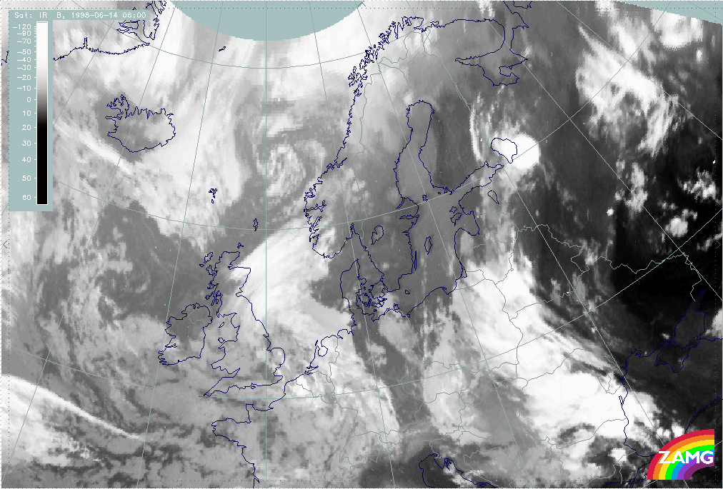
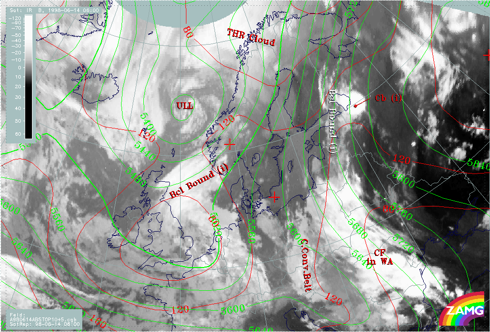
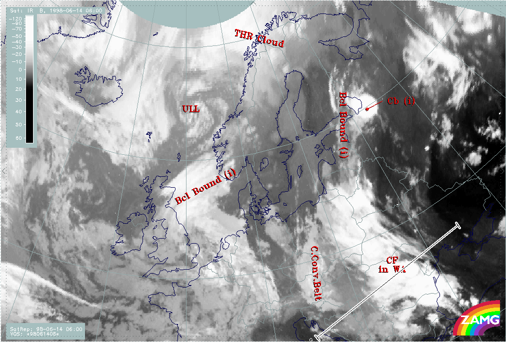
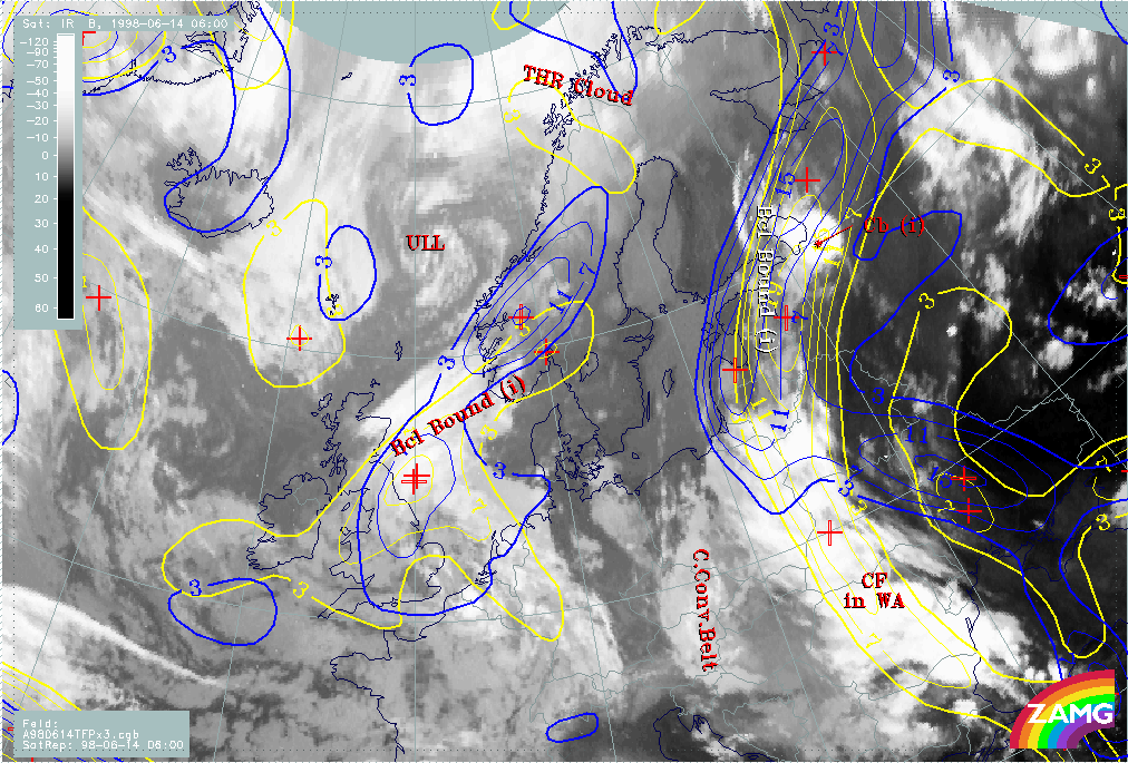
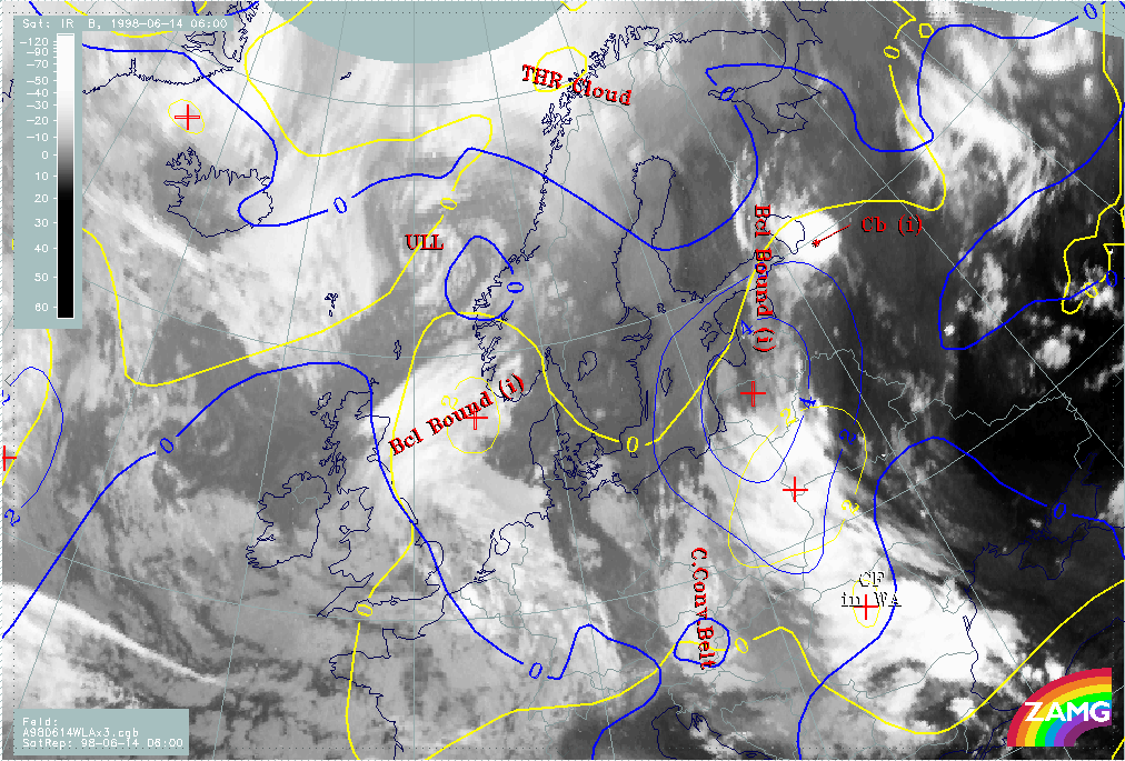
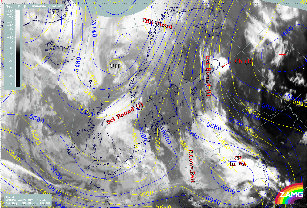
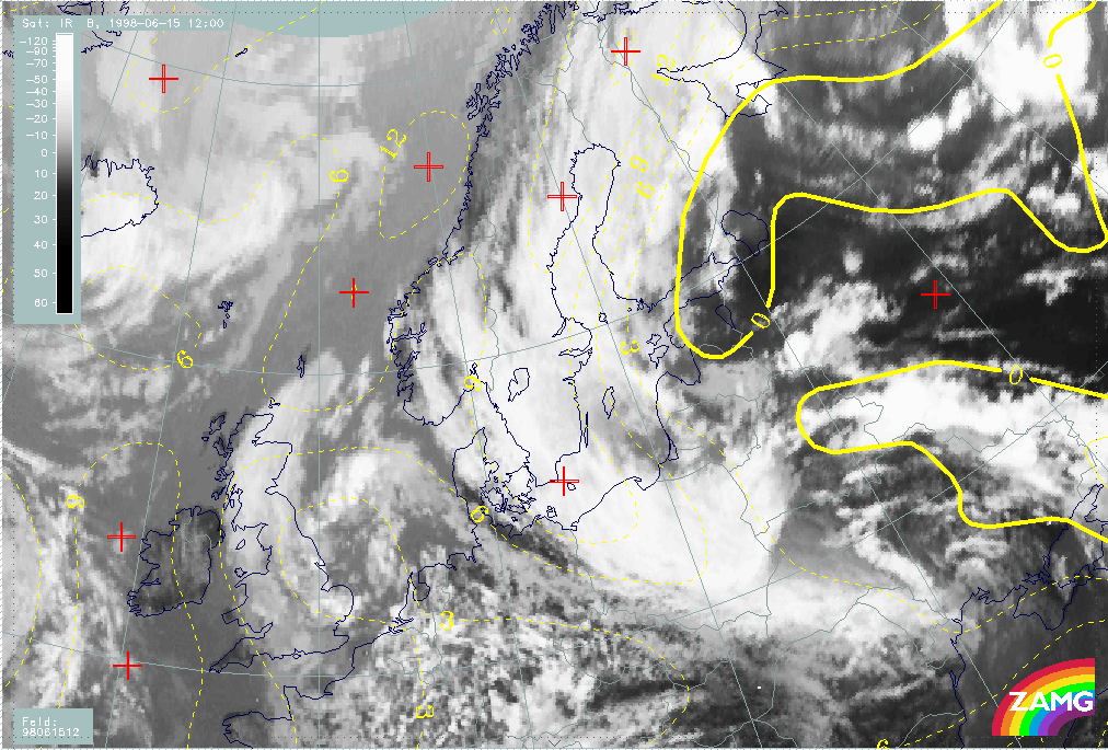
The IR, VIS and WV satellite images of the 14th June 06.00 UTC show the initial state of this case study, with warm air moving from the Black Sea to Finland.
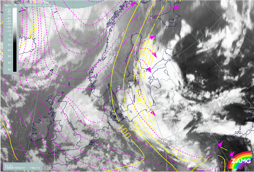
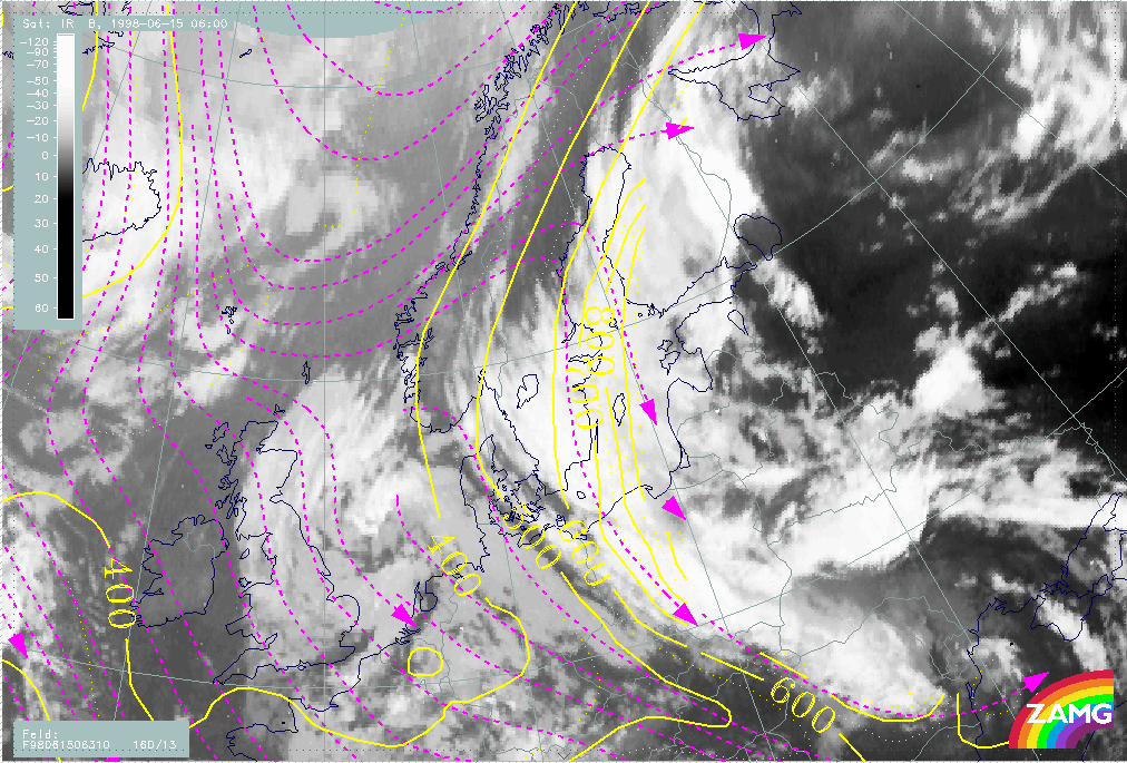
From the IR image (H00) it can be seen that between the warm airmass over Russia and eastern parts of the Ukraine, White-Russia and the colder airmass over Scandinavia and central Europe there is a long structured band of clouds. Over Romania and Poland it looks like a frontal cloud band with cold cloud tops and embedded convective cells. Further to the north (Baltic states and Eastern Finland) the cloud looks more like an anticyclonically curved cloud band. It has lower cloud tops than the frontal clouds, but it is connected with a huge circular MCS around 60N/33E. Over the Czech Republic and Austria the cloud bands resemble an Occlusion of the Cold Conveyor Belt type.
Furthermore there seems to be a cyclonic eddy structure over the Norwegian Sea centered at 65N/03E with extended cyclonically curved cloud bands along the boundaries. These features are indicative of an Upper Level Low (ULL). A distinct cloud band over the North Sea from England to Norway has the structure of a Baroclinic Boundary and might be associated with the ULL. However, in this case study we only concentrate on the clouds over eastern Europe.
|
14 June 1998/06.00 UTC - Meteosat IR image
|
|
|
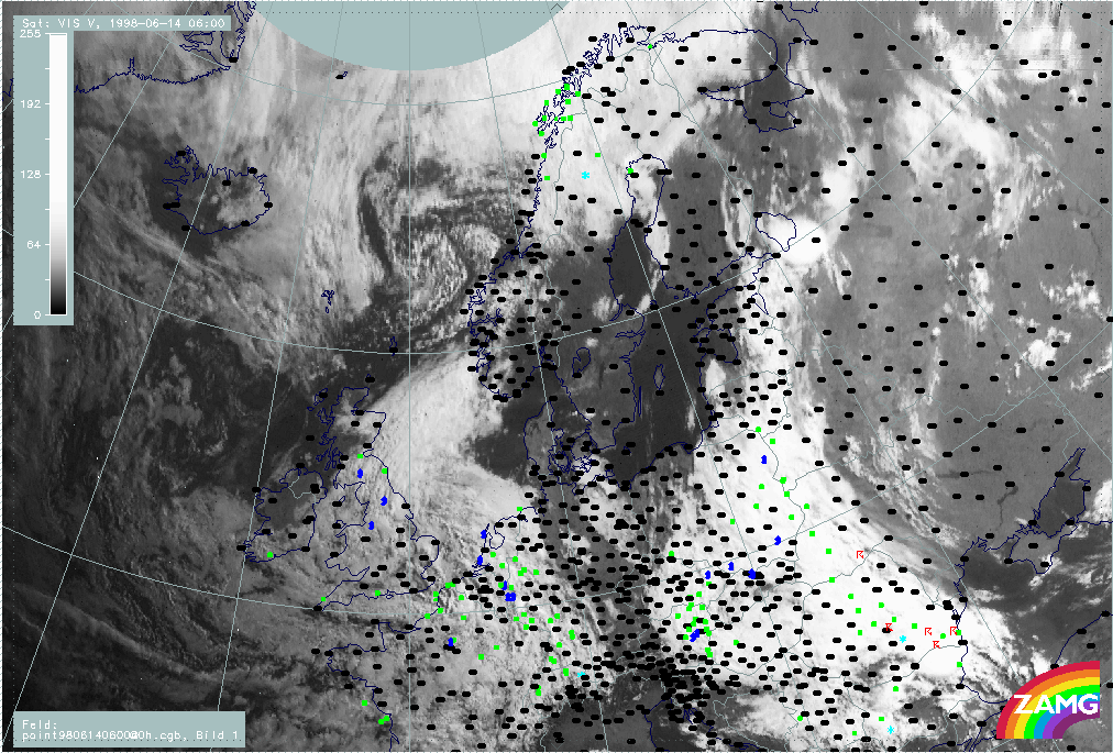
All the IR features are recognizable in the VIS image (H01) as well. The grey shade difference on the area of the Occlusion (typical for the CCB type) is not as distinct as in the IR image. The small scale cloud band over Western Finland can be seen better. There was a lot of precipitation within the frontal cloud band (Romania - Baltic States) and thunderstorms within the eastern edge, in southern parts, were observed. The cloud band from the Baltic States to Finland produced no precipitation at this stage. A lot of precipitation is also observed in the southernmost (thickest) part of the cloud over Eastern Austria.
|
14 June 1998/06.00 UTC - Meteosat VIS image; weather events (green: rain and showers, blue: drizzle, cyan: snow, red: thunderstorm with
precipitation, purple: freezing rain, orange: hail, black: no actual precipitation or thunderstorm with precipitation)
|
|
|
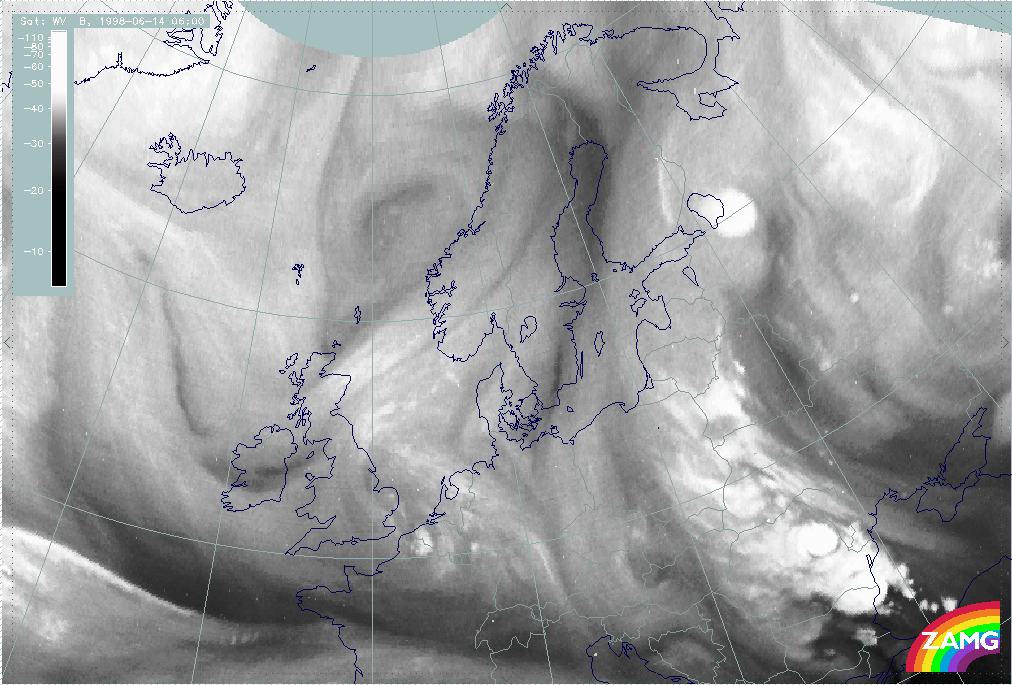
The Water Vapor image (H02) clearly shows the thick cellular convective areas of the cloud band from Romania to the Baltic States. The cloud bands extending from the Baltic States to Finland are much broader than the IR bands in this area. There is a distinct boundary between wet and dry air along the west coast of Finland.The CCB Occlusion appears to be well developed and detached from the front in WV. A Comma - like feature in the WV image over Northern Finland cannot be identified in IR or VIS images.
|
14 June 1998/06.00 UTC - Meteosat WV image
|
|
|
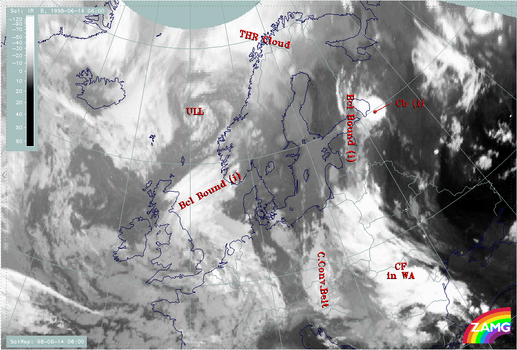
As a summary of the initial state we can look at the IR image with the names of conceptual models superimposed based on satellite features and relevant NWP output (H03). With this additional information (not derivable from satellite imagery alone) the frontal cloud band from Romania to Bulgaria can be identified as a Cold Front in Warm Advection. Not superimposed on the picture is the fact, that from Bulgaria northward the frontal clouds can be identified as a Warm Front Band.
|
14 June 1998/06.00 UTC - Meteosat IR image; SatRep overlay: names of conceptual models
|
|
|
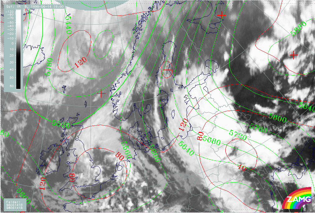
14 June/06.00 UTC: Frontal Diagnosis
Frontal analysis
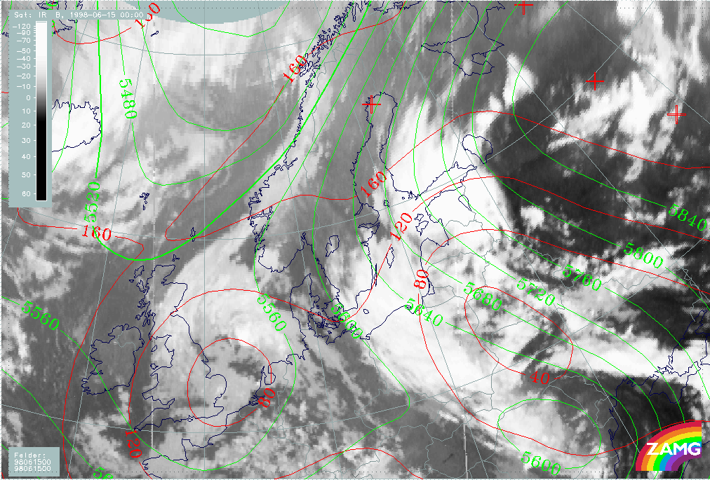
We concentrate on the area of frontal cloud bands stretching from Romania to Finland (H04).
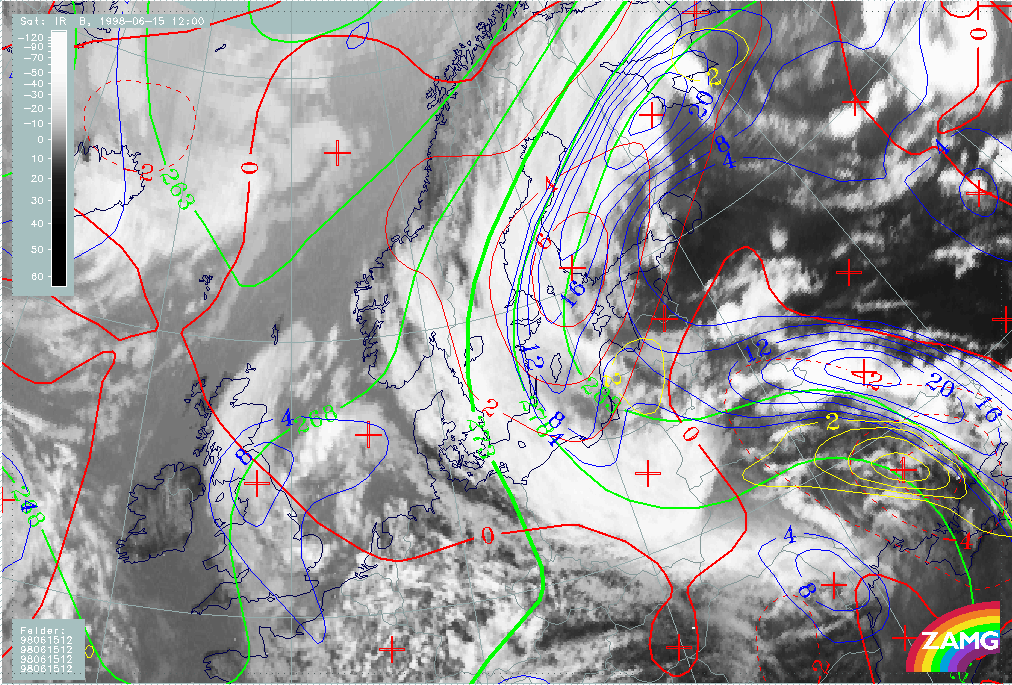
The surface (1000 hPa height contour) shows a flat indistinct low over the Balkan Peninsula and the Black Sea and a secondary weak minimum over
the Baltic States. From the synoptic analysis of surface observations (not shown), one centre of the Balkan Peninsula low lies just within the
area of the CF in WA, but over the Baltic States no center can be found. The 500 hPa height contours show a very pronounced upper level trough
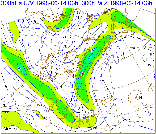
in the area of the CCB Occlusion. The many parallel contours reaching from Poland to Finland indicate a broad upper level flow from south to
north or northeast. The 300 hPa isotach field (Fig. H04B) shows this even clearer; a moderate jet stretching from the western Black Sea over
Finland then all the way up to the Barents Sea.
|
14 June 1998/06.00 UTC - Meteosat IR image; red: height contours 1000 hPa, green: height contours 500 hPa
|
14 June 1998/06.00 UTC - black: height contours 300 hPa, blue: isotachs
|
|
|
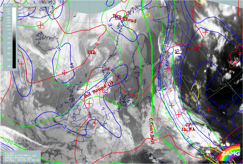
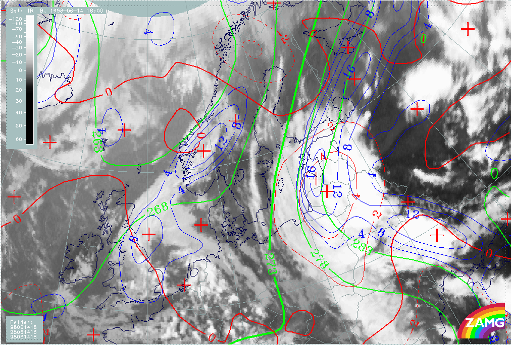
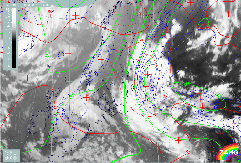
Image H05 shows that the cloud bands extending from Romania to Finland are located within frontal conditions. A distinct zone of high thickness gradient from the Balkan Peninsula (CF in WA) extends northward to Finland. The thermal front parameter TFP is located very close to the warm side of this zone - especially on the leading edge of the Baroclinic Boundary cloudiness - but is located more to the rear in the region of the CF in WA. The absence of TFP curvature and TFP around the CCB Occlusion indicates the Occlusion to be a leftover of a previous frontal system and to have only a minor relationship to the frontal band in this study. The maximum of warm advection lies over Poland and White Russia. Only one synoptically important positive vorticity advection (PVA) maximum is located in the south-eastern part of the CF. But noteworthy are the TFP values and the small PVA - area within the warm airmass over Russia, because they are located just at the location of MCS development the following day.
|
14 June 1998/06.00 UTC - Meteosat IR image; green: height contours 500 hPa , red: temperatures advection - WA 500 hPa, yellow: positive
vorticity advection (PVA) 500 hPa
|
|
|
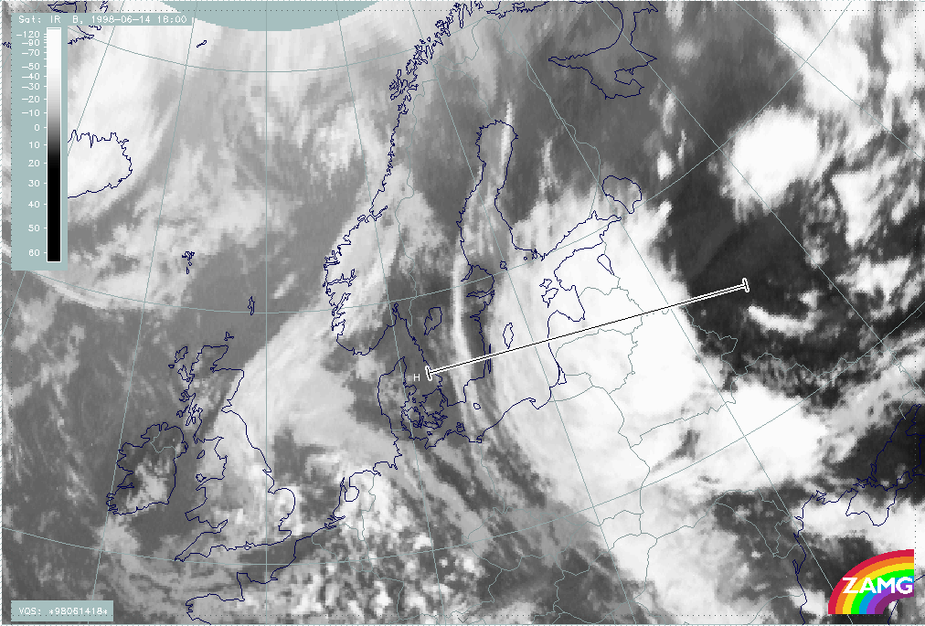
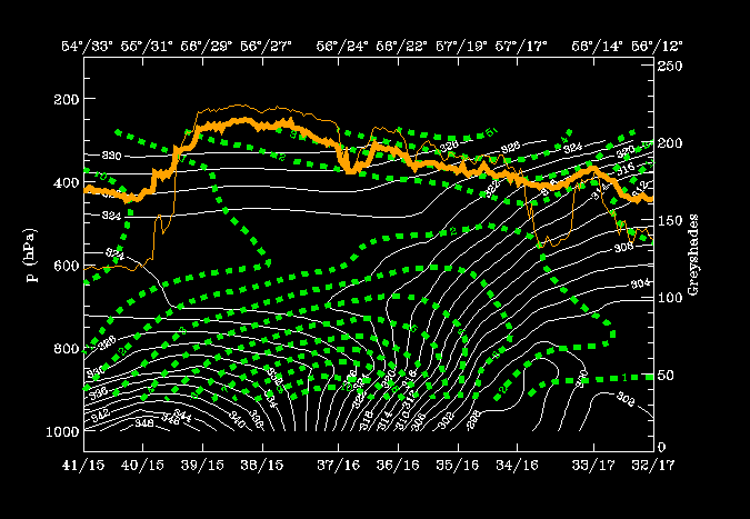
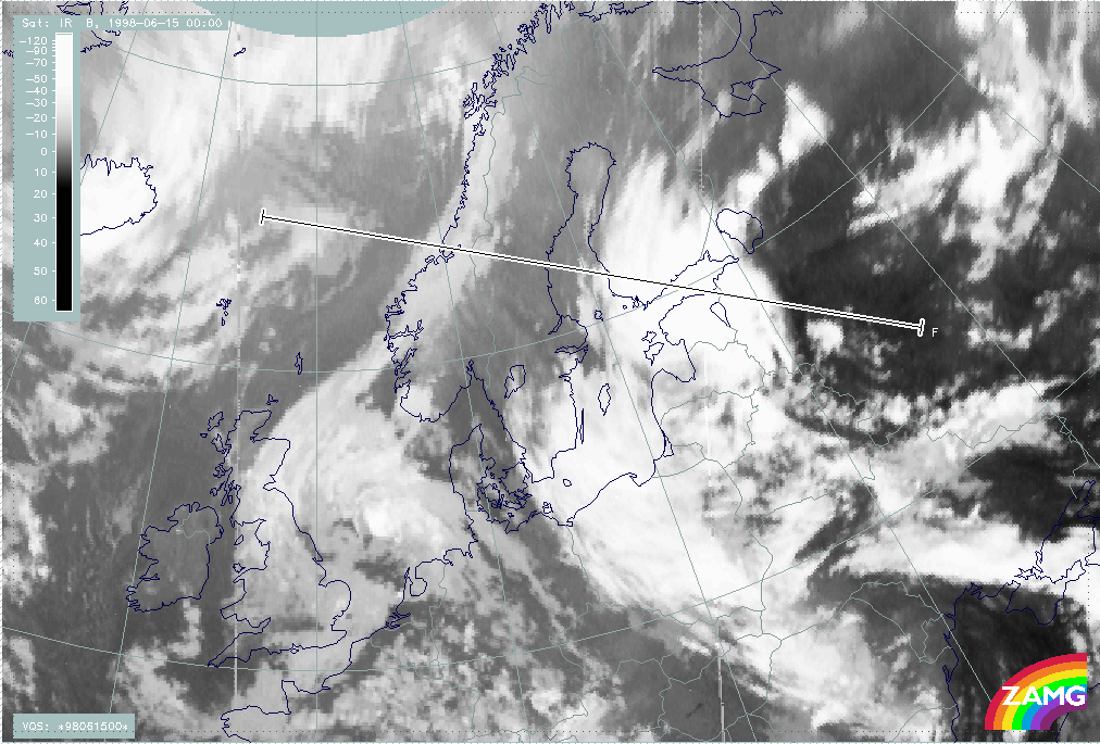
Vertical Cross Sections
The vertical cross-section line lies perpendicular to the CF in WA with orientation from the cold to the warm side (SW-NE), as shown in image H08.
|
14 June 1998/06.00 UTC - Meteosat IR image; SatRep overlay: names of conceptual models; position of vertical cross section indicated
|
|
|
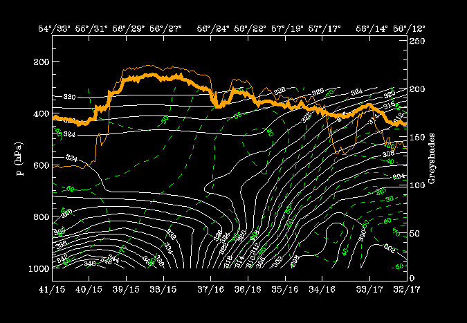
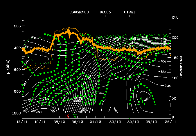
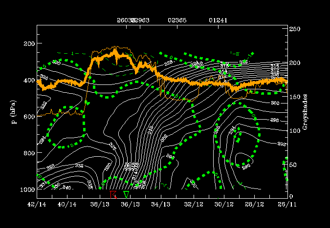
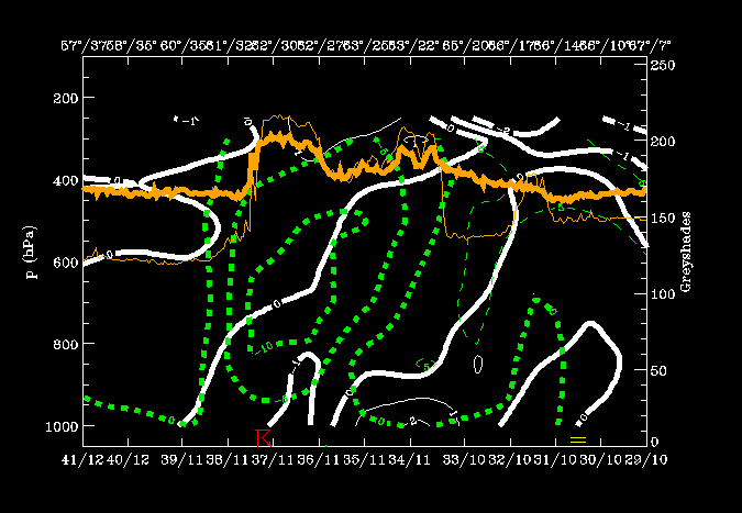
Isentropes and satellite pixel values:
In fig. H09 there is a high gradient of isentropes (~ 310-316K) from 400 hPa at 44N/14E down to the surface at 46N/24E, which indicates a frontal zone. Very unstable air is situated immediately ahead of the frontal zone from the surface up to 650 hPa. The cloudiness is represented by a broad peak of grey shades (45N/22E - 46N/26E) in front of the frontal zone and in the unstable area. Some rainshowers were reported along the front.
Temperature advection:
WA can be found within and ahead of the frontal zone but only up to 650 hPa. Upper-air cold advection is overrunning the frontal zone, which clearly increases the instability. This is the more unusual type of CF in WA, because usually the WA is situated above the CA which weakens the front, however, in this case, the front is intensifying.
|
14 June 1998/06.00 UTC - Vertical cross section; white: isentropes (ThetaE), green thin: temperature advection - CA, green thick:
temperature advection - WA, orange thin: IR pixel values, orange thick: WV pixel values
|
|
|
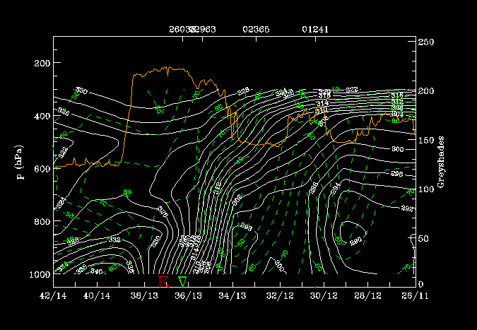
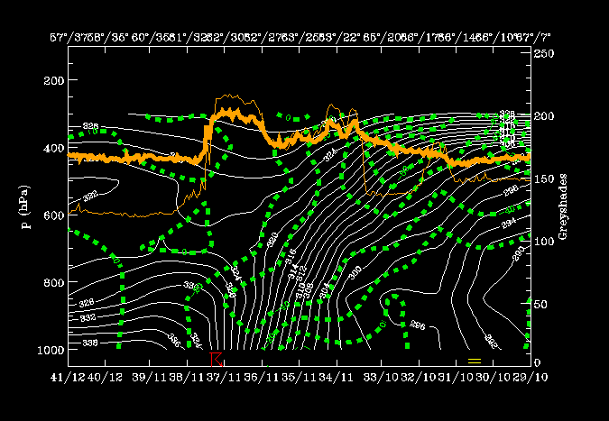
In Fig. H12 a zone of convergence is associated with the frontal zone. This is very typical for well developed fronts and contributes to the frontal circulation. Intensive upward motion is located ahead and on top of the frontal zone coincident with frontal and pre-frontal cloudiness. This is a typical configuration of a frontal circulation cell. Convergence within the frontal surface results in upward motion immediately above. The structure of the isentropes in the frontal area would suggest a Kata type Cold Front.
|
14 June 1998/06.00 UTC - Vertical cross section; white thin: divergence, white thick: convergence, green thick: vertical motion (omega)
- upward motion, green thin: vertical motion (omega) - downward motion, orange thin: IR pixel values, orange thick: WV pixel values
|
|
|
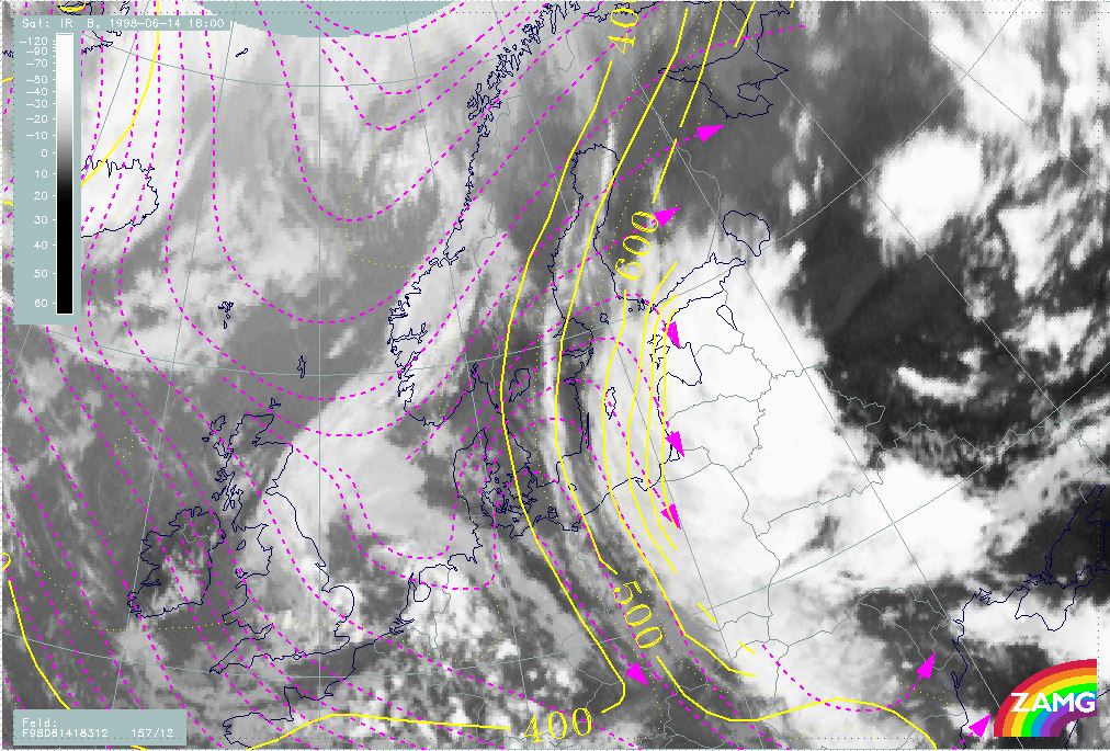
VSRF: 14 June 06.00 - 18.00 UTC
Focusing on the development of the baroclinic boundary from 06.00 to 18.00 UTC on 14 June, we see a general northward movement in TFP in Fig. H30. Over Finland the boundary moves slightly to the west. The TFP reaches eastern Finland by 18.00 UTC. The CF part moves very fast northeastward.
|
14 June 1998/06.00 UTC - Meteosat IR image; yellow: thermal front parameter 500/850 hPa 06.00 UTC, blue: thermal front parameter
500/850 hPa 18.00 UTC
|
|
|
The temperature advection (H31) shows the same characteristics as TFP. There is northward movement of the WA maximum over Poland - White Russia at 06.00 UTC to the Baltic States at 18.00 UTC. At the same time the WA maximum is intensifying.
|
14 June 1998/06.00 UTC - Meteosat IR image; yellow: temperature advection - WA 06.00 UTC, blue: temperature advection - WA 18.00 UTC
|
|
|
Looking at the 500 hPa height contours (H32), there is an eastward shift and intensification of the upper level trough over the Balkan peninsula and even the formation of an Upper Level Low. The continuous broad upper level flow from the south to Finland stays strong and even strengthens over the Ukraine.
|
14 June 1998/06.00 UTC - Meteosat IR image; yellow: height contours 500 hPa 06.00 UTC, blue: height contours 500 hPa 18.00 UTC
|
|
|
Tying these NWP observations to the 18 UTC satellite image we have a verification for the predicted development. The northward movement of the baroclinic boundary can also be seen in the cloudiness ahead and within the TFP areas over the Baltic Sea, the Baltic States and Southern Finland (H33). The cloudiness appearing within the warm sector in western Russia indicates unstable developments.
|
14 June 1998/18.00 UTC - Meteosat IR image; yellow: thermal front parameter 500/850 hPa 06.00 UTC, blue: thermal front parameter
500/850 hPa 18.00 UTC
|
|
|
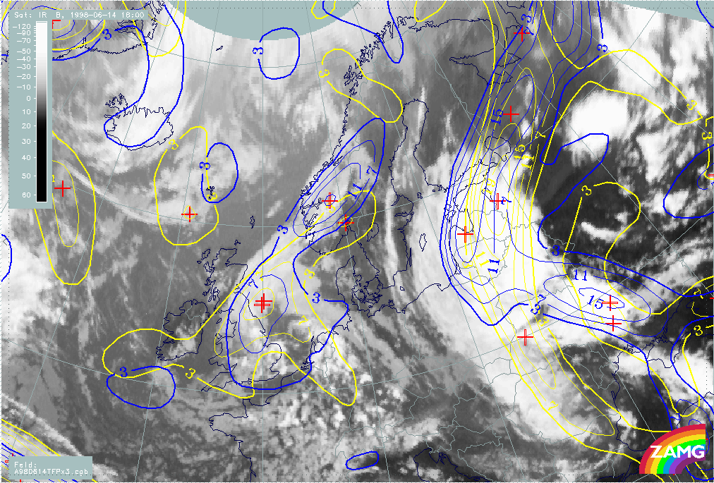
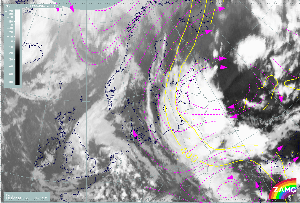
14 June/18.00 UTC: Frontal diagnosis
Satellite Overview
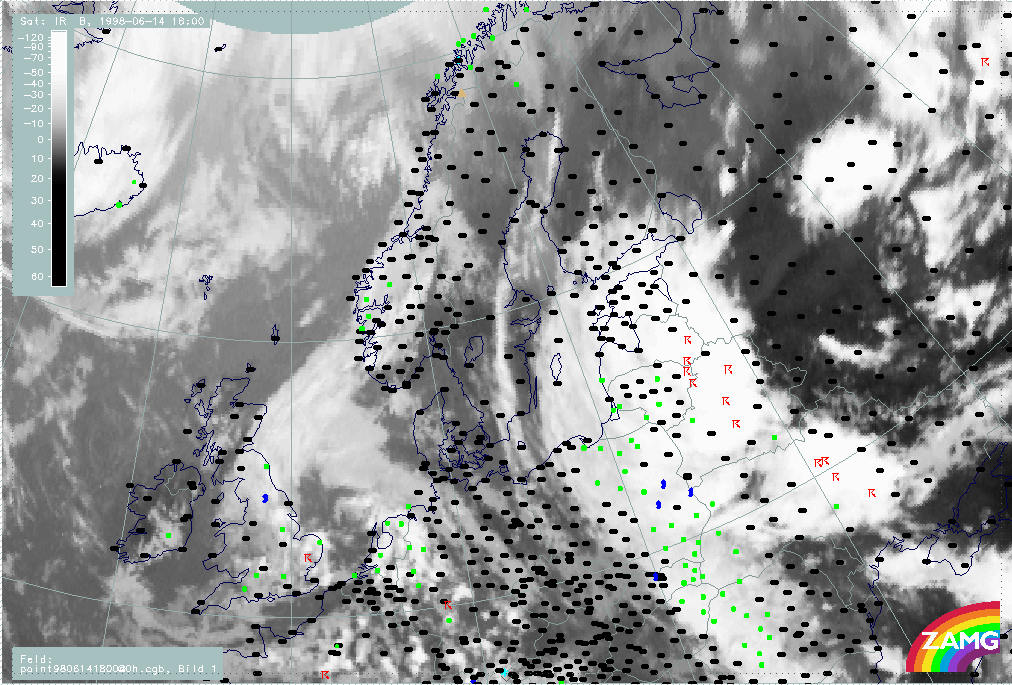
We continue with a more thorough analysis of the frontal cloud bands from 14 June 06.00 UTC. By 18.00 UTC a Warm Front cloud band is stretching from Poland over White Russia to the Baltic States and Finland (H33a). Precipitation is observed within the southern part of the Warm Front and many thunderstorms were reported along the eastern parts of the Warm Front.
|
14 June 1998/18.00 UTC - Meteosat IR image; weather events (green: rain and showers, blue: drizzle, cyan: snow, red: thunderstorm with
precipitation, purple: freezing rain, orange: hail, black: no actual precipitation or thunderstorm with precipitation)
|
|
|
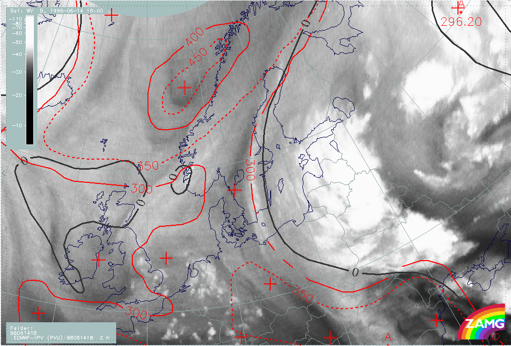
Parameters on isobaric surfaces
In Fig. H34 there is a distinct WV band over Finland with a sharp edge to a darker stripe over Sweden. The zero line of shear vorticity lies close to this westward boundary but approximately 1 - 2 degrees more to the east. The transition between tropospheric and stratospheric air at 300 hPa is very close to the sharp WV boundary. The eastward displacement of the zero line of shear vorticity when compared to the dry stripe in WV does not match the classical ideas, and could be interpreted as a model error.
|
14 June 1998/18.00 UTC - Meteosat WV image; red: height of PV=2 units, black: shear vorticity 300 hPa
|
|
|
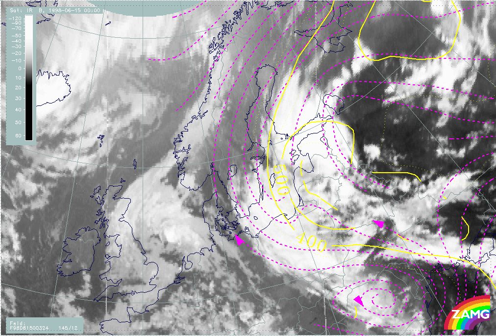
In 12 hours the surface low at 50N/28W has intensified and there is a strong upper level southerly flow above (H35). The cloudiness over Poland, Baltic States and Finland clearly shows the Warm Frontal character. The Cold Front cloudiness over Romania and the Black Sea is very disorganized. The upper level trough over Romania has been cut off to form an Upper Level Low, which is an untypical development for a Cold Front. The cloudiness within the Baroclinic Boundary and the upper level trough existed before the surface low developed. It is more a reformation of cloud structures rather than a new development.
|
14 June 1998/18.00 UTC - Meteosat IR image; red: height contours 1000 hPa, green: height contours 500 hPa
|
|
|
In Fig. H36 a zone of high thickness gradient to the rear of the CF area, but within the WF cloudiness, is noticeable. The TFP lies at leading edge of the thickness gradient. The TFP is located within WF cloudiness, however, the more eastern higher cloud patches are associated with the unstable development, not with a frontal system. An intensive WA maximum over the WF cloud band extends into the unstable areas behind the front. The zero line of warm advection crosses the centre of the surface low (see H35), which is very typical at this stage of development.
|
14 June 1998/18.00 UTC - Meteosat IR image; blue: thermal front parameter (TFP) 500/850 hPa, green: equivalent thickness 500/850 hPa,
red: temperature advection - CA 1000 hPa
|
|
|
Vertical Cross Sections
The vertical cross-section line lies perpendicular to the Warm Front cloud band and its unstable areas. The orientation lies close to east to west (H37).
|
14 June 1998/18.00 UTC - Meteosat IR image; position of vertical cross section indicated
|
|
|
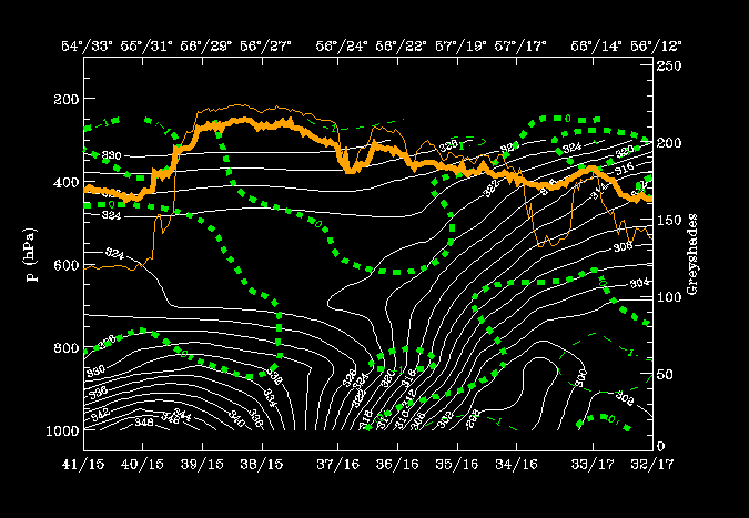
Isentropes and satellite pixel values:
There are two interesting areas in the isentropes (Fig. H38):
- An extremely unstable air mass from the surface up to 650 hPa east of the WF and
- A distinct WF zone with high gradients from the surface, at approximately 56N/23E, up to 300 hPa over 56N/12E.
A broad peak of highest IR and WV values lies over the unstable area and somewhat lower values on top of the WF. A separate peak at 56N/15E belongs to the cloud fibre at the western boundary of the WV band.
Relative humidity:
A zone of high humidity values (90 %) is situated over the Warm Fronts zone (H38). The lowest values (20 - 30%) appear below the frontal zone (below 304K at 56N/14E). This is to be expected in a Warm Front of band type.
|
14 June 1998/18.00 UTC - Vertical cross section; white: isentropes (ThetaE), green: relative humidity, orange thin: IR pixel values,
orange thick: WV pixel values
|
|
|
Warm advection:
In Fig. H39 warm advection dominates the vertical cross section with highest values within the WF zone. There are high values also in the area of the unstable air, but only up to 700 hPa. Not a typical distribution of warm advection in a Warm Front.
|
14 June 1998/18.00 UTC - Vertical cross section; white: isentropes (ThetaE), green thin: temperature advection - CA, green thick:
temperature advection - WA, orange thin: IR pixel values, orange thick: WV pixel values
|
|
|
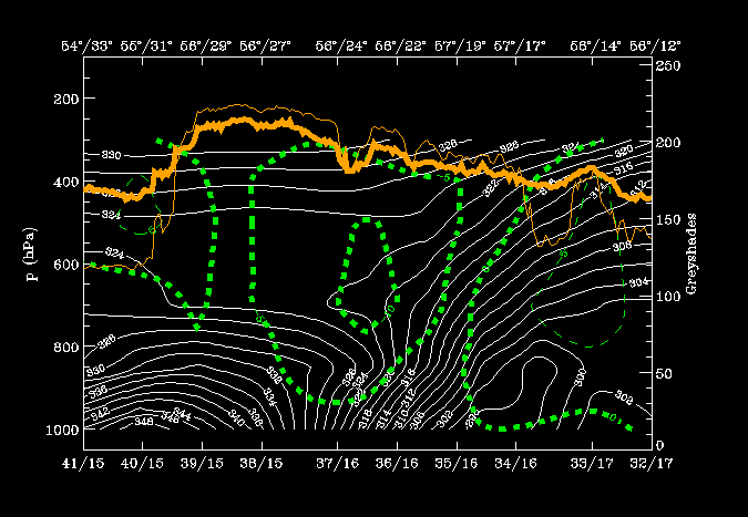
Convergence:
The convergence field in Fig. H40 is not pronounced. The only region indicating a frontal convergence zone is the lowest layer of the WF at 850 hPa around 56N/22E, but even there it is quite weak. Even so it also has some of the qualities of a Warm Front cloud band.
|
14 June 1998/18.00 UTC - Vertical cross section; white: isentropes (ThetaE), green thin: divergence, green thick: convergence, orange
thin: IR pixel values, orange thick: WV pixel values
|
|
|
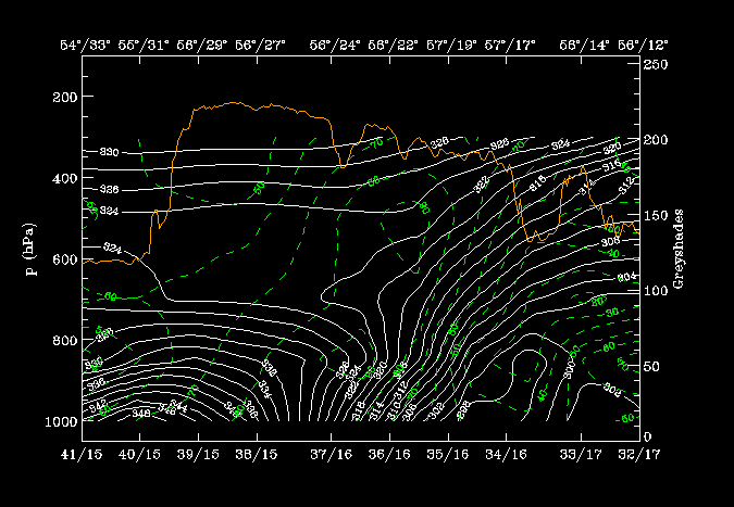
Vertical motion:
An extensive zone of upward motion is located on the WF as well as to the rear, above the unstable area (H41). A distinct area of descending air lies between these zones. As before the upward motion is typical for a Warm Front cloud band.
|
14 June 1998/18.00 UTC - Vertical cross section; white: isentropes (ThetaE), green thick: vertical motion (omega) - upward motion,
green thin: vertical motion (omega) - downward motion, orange thin: IR pixel values, orange thick: WV pixel values
|
|
|
With help of parameters on isentropic surfaces: Air mass separation
Selection of relevant isentropic surfaces (Fig. H42):
- 312K: to see what happens within the WF surface in the middle and low part of the zone.
- 322K: to observe the situation partly directly on top and partly further above the WF surface. (Relative streams on 322K can only be evaluated from the eastward boundary westwards to 56N/24E because of intenive instability below.)
|
14 June 1998/18.00 UTC - Vertical cross section; white: isentropes (ThetaE), green: relative humidity, orange thin: IR pixel values,
orange thick: WV pixel values
|
|
|
Within the frontal zone, the isentropes are inclined downward from 400 to 900 hPa and the relative streams are strongly descending, which is very typical for the lower part of the frontal surface (H43).
|
14 June 1998/18.00 UTC - Meteosat IR image; magenta: relative streams 312K, yellow: isobars
|
|
|
In the image below (H44), there is completely different situation above the front: a heavily rising Warm Conveyor Belt over the Baltic States with streamlines turning and sinking again over Finland where the cloudiness ends. Furthermore a relative stream to the south over Romania is connected with the old CCB Occlusion and clearly indicates a different air mass.
|
14 June 1998/18.00 UTC - Meteosat IR image; magenta: relative streams 322K, yellow: isobars
|
|
|
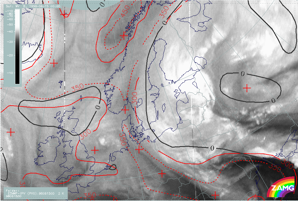
15 June/00.00 UTC: Frontal diagnosis
Satellite Overview
On 15 June a northward penetration of cloudiness takes place over Finland (Fig. H47). A double structure has developed at the Warm Front system; one part over Poland, Baltic Sea and Sweden, the other over the Baltic States and Finland. The old CCB Occlusion is still well developed. The connection from the Warm Front to the Cold Front is rather unorganized as seen in the cloud structures over the Baltic States and White Russia. The Cold Front becomes more organized over the area from the Ukraine to the Black Sea. There are many thunderstorms observed over Estonia. Notably, there is no precipitation in the downstream parts of the two cloud shields.
|
15 June 1998/00.00 UTC - Meteosat IR image; weather events (green: rain and showers, blue: drizzle, cyan: snow, red: thunderstorm with
precipitation, purple: freezing rain, orange: hail, black: no actual precipitation or thunderstorm with precipitation)
|
|
|
Parameters on isobaric surfaces
Compared to earlier water vapour images, there has been westward movement of the dark WV band in Fig. H48. A sharp boundary between tropospheric and stratospheric air is evident over Sweden. The eastward shift of zero line of shear vorticity at 300 hPa could again be a model error.
|
15 June 1998/00.00 UTC - Meteosat WV image; red: height of PV=2 units, black: shear vorticity 300 hPa
|
|
|
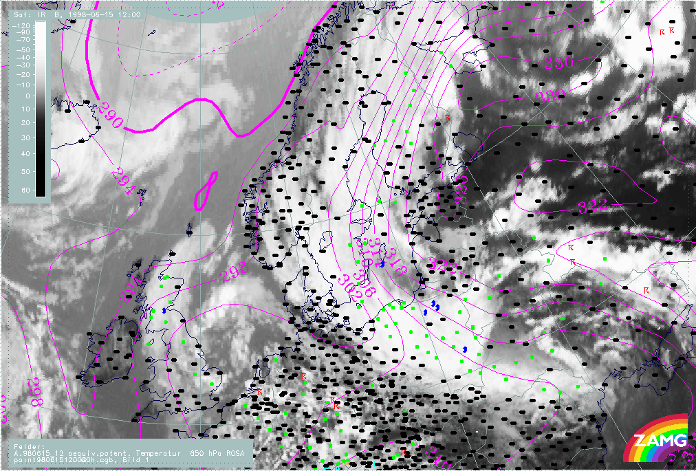
In Fig. H49 the surface low is still associated with the rather chaotic cloud structures of the Cold and Warm Front bands. The double structure of the Warm Front Band results from two different parts of the upper level stream, caused by the Upper Level Low over Romania.
|
15 June 1998/00.00 UTC - Meteosat IR image; red: height contours 1000 hPa, green: height contours 500 hPa
|
|
|
The Warm Front Band stretching from the Baltic States to Finland shows distinct frontal character in every aspect: thickness gradient, TFP and WA (Fig. H50). The cloud structures from Poland to Sweden belong more to the upper level stream and are without a distinct front character.
|
15 June 1998/00.00 UTC - Meteosat IR image; blue: thermal front parameter (TFP) 500/850 hPa, green: equivalent thickness 500/850 hPa,
red: temperature advection - CA 1000 hPa
|
|
|
Vertical Cross Sections
The vertical cross section line is perpendicular to the Warm Front over Finland and the Baroclinic Boundary over Norway. The orientation crosses the Warm Front from east to west (Fig. H51).
|
15 June 1998/00.00 UTC - Meteosat IR image; position of vertical cross section indicated
|
|
|
Isentropes and satellite pixel values:
Very distinct Warm Front Band with very unstable air within and in the rear can be seen in Fig. H52. Broad IR and WV pixel value peaks are associated with both systems. The second IR peak is situated around station 01241 in front of the very steep zone of high gradient of isentropes. It corresponds to the Norwegian Baroclinic Boundary.
Temperature advection:
There is distinct WA within the WF zone from the surface up to 300 hPa (Fig. H52). There is also WA in the unstable area in front of it up to 650 hPa with CA above - a typical distribution for instability. There is only very weak WA over Norway associated with the Baroclinic Boundary.
|
15 June 1998/00.00 UTC - Vertical cross section; white: isentropes (ThetaE), green thin: temperature advection - CA, green thick:
temperature advection - WA, orange thin: IR pixel values, orange thick: WV pixel values
|
|
|
Convergence:
In fig. H53 no distinct convergence associated with the WF can be seen, but there is some convergence in the region of the Baroclinic Boundary over Norway between approx. 900 - 600 hPa. The Warm Front Band characteristics are still clear to see.
|
15 June 1998/00.00 UTC - Vertical cross section; white: isentropes (ThetaE), green thin: divergence, green thick: convergence, orange
thin: IR pixel values, orange thick: WV pixel values
|
|
|
With help of parameters on isentropic surfaces: Air mass separation
Selection of characteristic isentropic surfaces (Fig. H54):
- 312K: is within the Warm Front zone
- 324K: is partly directly on top of the Warm Front zone and partly further above, thus only relevant west of the unstable air mass.
|
15 June 1998/00.00 UTC - Vertical cross section; white: isentropes (ThetaE), green: relative humidity, orange thin: IR pixel values,
orange thick: WV pixel values
|
|
|
The 312K image shows a downward inclination of isobars from 400 to 800 hPa and a strong sinking of the relative streams from the west (Fig. H55).
|
15 June 1998/00.00 UTC - Meteosat IR image; magenta: relative streams 312K, yellow: isobars
|
|
|
The 324K image shows a rising Warm Conveyor Belt in the relative streams from the Baltic States over Finland (Fig. H56).
|
15 June 1998/00.00 UTC - Meteosat IR image; magenta: relative streams 324K, yellow: isobars
|
|
|
Looking at the potential vorticity (Fig. H57) the moist tropospheric air in the the WV band lies below 300 hPa. The distinct gradient in the area of the Dark Stripe forms the boundary with stratospheric air above 300 hPa. As was the case 6 hours earlier, stratospheric air has descended below 300 hPa in the area of the Upper Level Low and to the rear of the Cold Front over the Black Sea.
|
15 June 1998/00.00 UTC - Meteosat WV image; cyan: height of PV=2 units 324K, red: isobars 324K
|
|
|
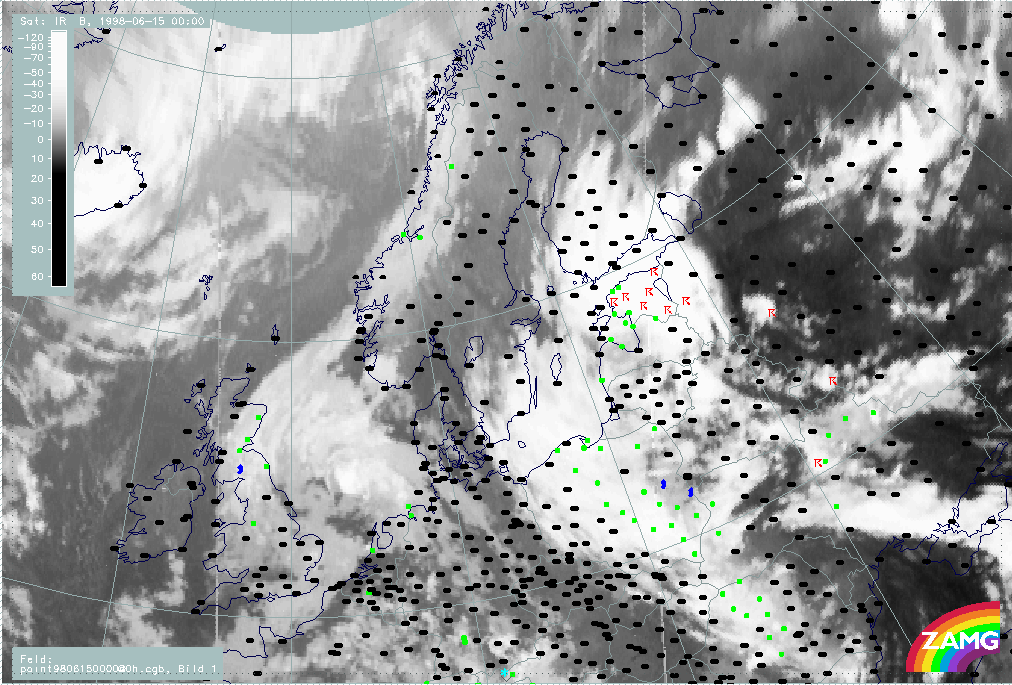
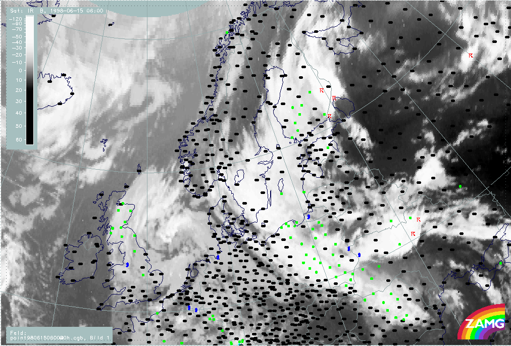
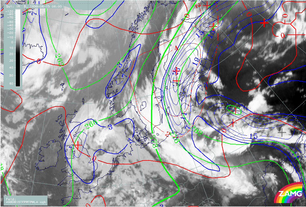
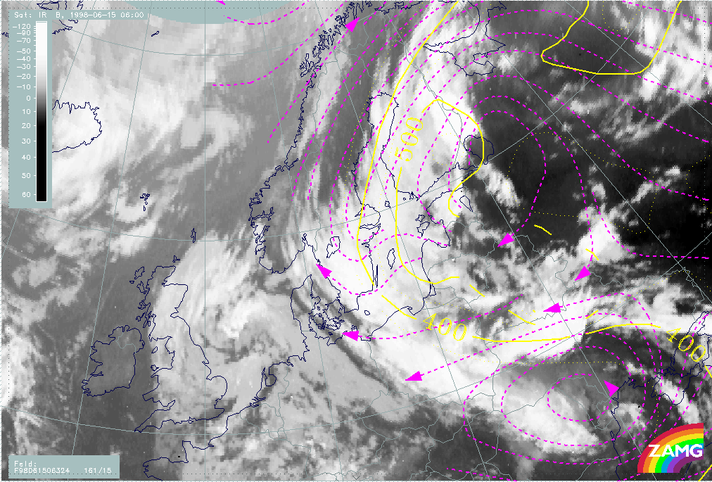
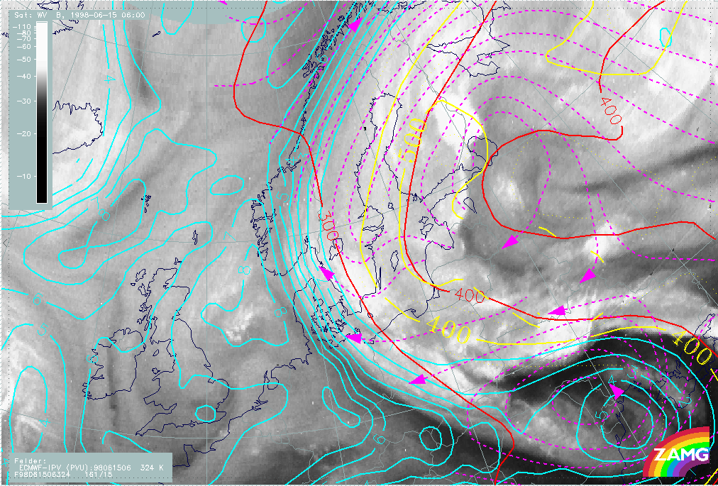
15 June/06.00 UTC: Frontal diagnosis
Satellite Overview
The distinct Warm Front Band over Finland is accompanied by precipitation (Fig. H59). The MCSs over Eastern Finland are accompanied by thunderstorms. The second part of the Warm Front structure from Poland to Sweden is also producing widespread precipitation. The chaotic cloud structures over the Baltic States have no connection with the Cold Front band structure over the Ukraine. The chaotic clouds could be partly explained by the Warm Conveyor Belt. The former CCB Occlusion still shows some remnants over Romania.
|
15 June 1998/06.00 UTC - Meteosat IR image; weather events (green: rain and showers, blue: drizzle, cyan: snow, red: thunderstorm with
precipitation, purple: freezing rain, orange: hail, black: no actual precipitation or thunderstorm with precipitation)
|
|
|
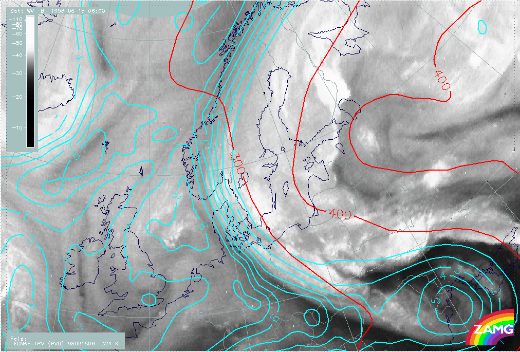
Parameters on isobaric surfaces
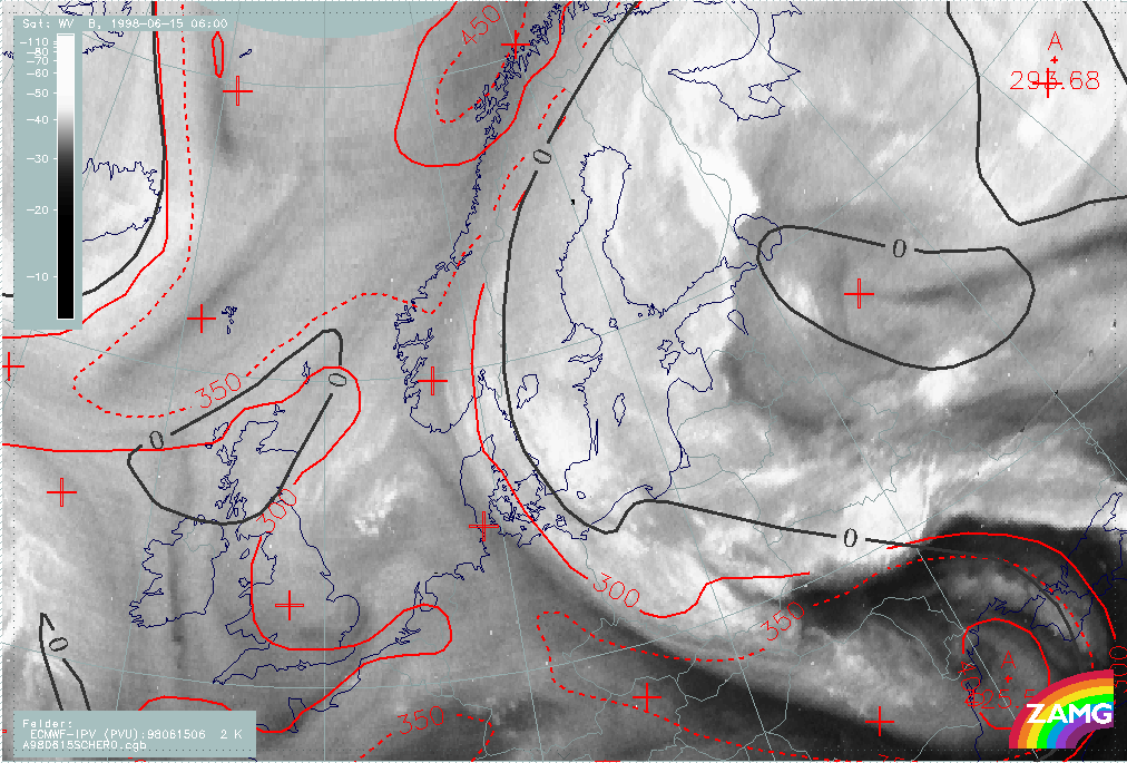
In the WV image (H60), an appearance similar to that of 18.00 and 00.00 UTC can be seen; the broad WV band has moved westward across Sweden to Norway. The separation of tropospheric and stratospheric air at the western edge of the WV band is above 300 hPa. Again there is a displacement between the zero line of shear vorticity and the Dark Stripe in the WV image. Stratospheric air has descended down to 450 hPa in the ULL as well as behind the CF over the Black Sea.
|
15 June 1998/06.00 UTC - Meteosat WV image; red: height of PV=2 units, black: shear vorticity 300 hPa
|
|
|
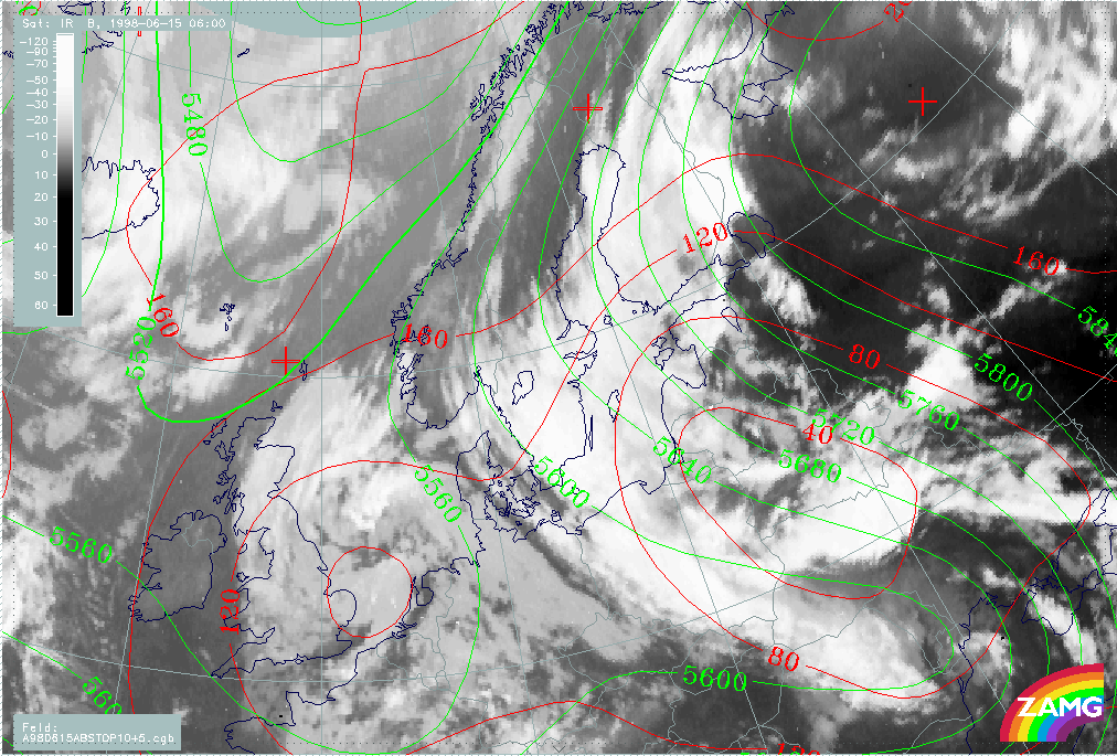
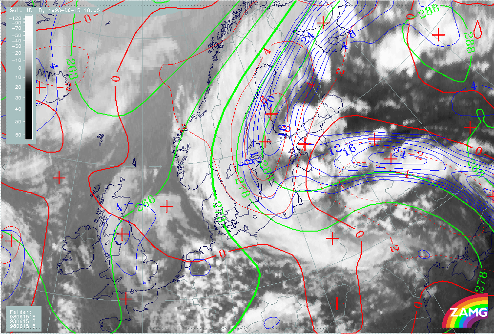
The situation is again very similar (H61). The area of the surface low is filled with very unstructured clouds. The Warm Front and Cold Front bands are generally coincident with surface troughs, and with the Swedish part of the Warm Front being better aligned with the upper level stream. This is not a typical development: the clouds of the Baroclinic Boundary and the upper level trough already existed before the surface lows developed. They are more a reformation of cloud structures rather than new developments
|
15 June 1998/06.00 UTC - Meteosat IR image; red: height contours 1000 hPa, green: height contours 500 hPa
|
|
|
The Warm Front characteristic is very distinct over the Baltic Sea and Finland, with respect to thickness gradient, TFP and WA maximum (H62). The zero line of temperature advection crosses the centre of the surface low.
|
15 June 1998/06.00 UTC - Meteosat IR image; blue: thermal front parameter (TFP) 500/850 hPa, green: equivalent thickness 500/850 hPa,
red: temperature advection - CA 1000 hPa
|
|
|
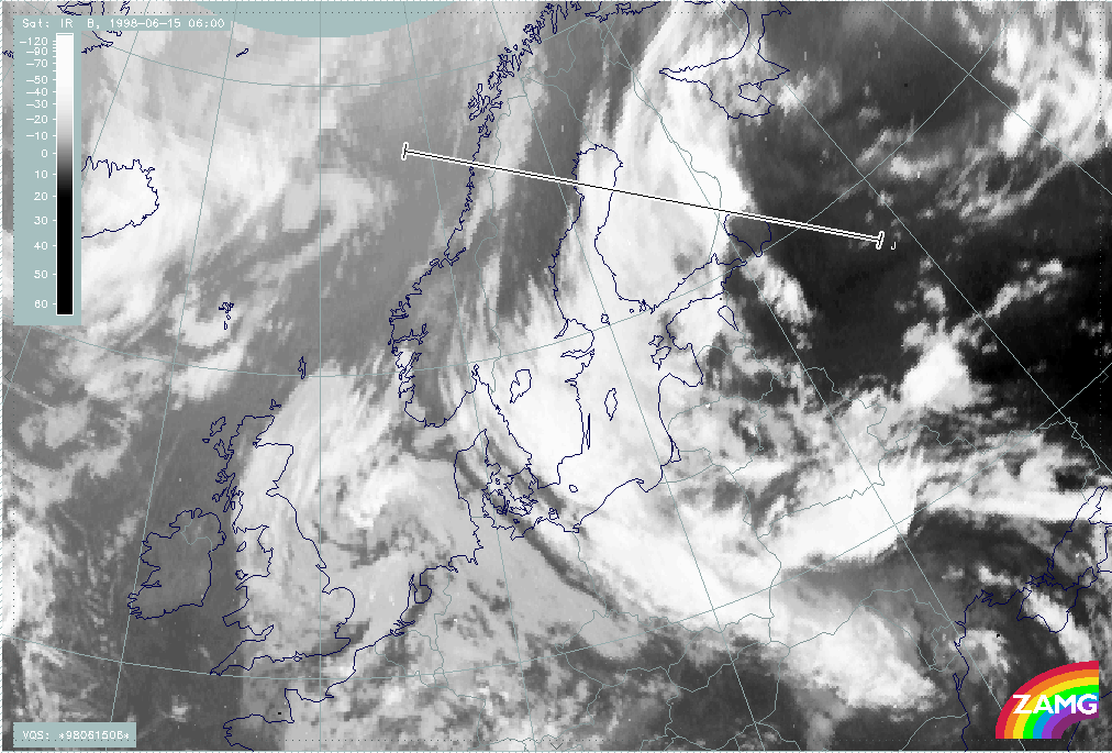
Vertical Cross Sections
The vertical cross section is drawn perpendicularly to the Warm Front Band over Finland and to the rest of the Baroclinic Boundary over Norway and crosses the Warm Front from east to west (H63).
|
15 June 1998/06.00 UTC - Meteosat IR image; position of vertical cross section indicated
|
|
|
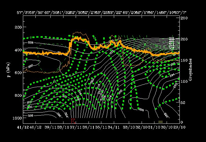
Temperature advection:
The vertical cross section is drawn perpendicularly to the WF band over Finland and to the rest of the Baroclinic Boundary over Norway and crosses the Warm Front from east to west (H63).
|
15 June 1998/06.00 UTC - Vertical cross section; white: isentropes (ThetaE), green thin: temperature advection - CA, green thick:
temperature advection - WA, orange thin: IR pixel values, orange thick: WV pixel values
|
|
|
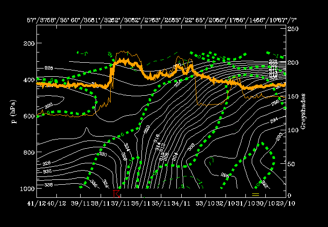
Convergence:
The zone of convergence is now more distinctly associated with the Warm Front zone than before; convergence within, divergence below and above (H65).
|
15 June 1998/06.00 UTC - Vertical cross section; white: isentropes (ThetaE), green thin: divergence, green thick: convergence, orange
thin: IR pixel values, orange thick: WV pixel values
|
|
|
Vertical motion:
A well developed circulation cell with convergence seen within the frontal zone, and with upward motion above it (H66); air is sinking below the frontal zone. There is very distinct agreement between upward motion and highest satellite pixel values.
|
15 June 1998/06.00 UTC - Vertical cross section; white thin: divergence, white thick: convergence, green thick: vertical motion
(omega) - upward motion, green thin: vertical motion (omega) - downward motion, orange thin: IR pixel values, orange thick: WV pixel
values
|
|
|
Frontogenetic forcing:
High values of frontogenesis are associated with the frontal zone (H67).
|
15 June 1998/06.00 UTC - Vertical cross section; white: isentropes (ThetaE), green: Q-Vector (normal component), orange thin: IR pixel
values, orange thick: WV pixel values
|
|
|
With help of parameters on isentropic surfaces: Air mass separation
Very typical distribution of humidity can be found: humid zone above the frontal zone, very dry zone below the frontal zone (H68). Selection of characteristic isentropic surfaces (Fig. H54):
- 310K: mainly within the frontal zone but more in the lower part;
- 324K lies above the frontal and unstable zones.
|
15 June 1998/06.00 UTC - Vertical cross section; white: isentropes (ThetaE), green: relative humidity, orange thin: IR pixel values,
orange thick: WV pixel values
|
|
|
Downward inclined isentropes (400 to 900 hPa) are dominant in the lower part of the frontal zone, which can be interpreted as sinking dry air (H69).
|
15 June 1998/06.00 UTC - Meteosat IR image; magenta: relative streams 310K, yellow: isobars
|
|
|
At a higher isentropic level (Fig. H70) the rising relative streams (w.c.b) can be found over the Baltic Sea and S. Finland, while the relative streams are more or less parallel to isobars or only slightly sinking in the northern part. To the rear of the Cold Front, and within the former CCB Occlusion, there exists a completely different relative stream, which shows that the separation of the relative streams between these two systems is now much more distinct than 6 hours earlier.
|
15 June 1998/06.00 UTC - Meteosat IR image; magenta: relative streams 324K, yellow: isobars
|
|
|
The PV field (H71) is similar to that 6 hours earlier. A distinct gradient between tropospheric and stratospheric air can be found at the western boundary of the WV band at a height of 300 hPa. In the troposphere, stratospheric air has penetrated downward behind the Cold Front over the Black Sea.
|
15 June 1998/06.00 UTC - Meteosat WV image; cyan: height of PV=2 units 324K, red: isobars 324K
|
|
|
The Warm Conveyor Belt transports warm moist tropospheric air upward, while the relative stream in the SE part of the image transports dry stratospheric air (H72).
|
15 June 1998/06.00 UTC - Meteosat WV image; cyan: height of PV=2 units 324K dry, red: isobars 324K dry, magenta: height of PV=2 units
324K wet, yellow: isobars 324K wet
|
|
|
VSRF: 15 June 06.00 - 18.00 UTC
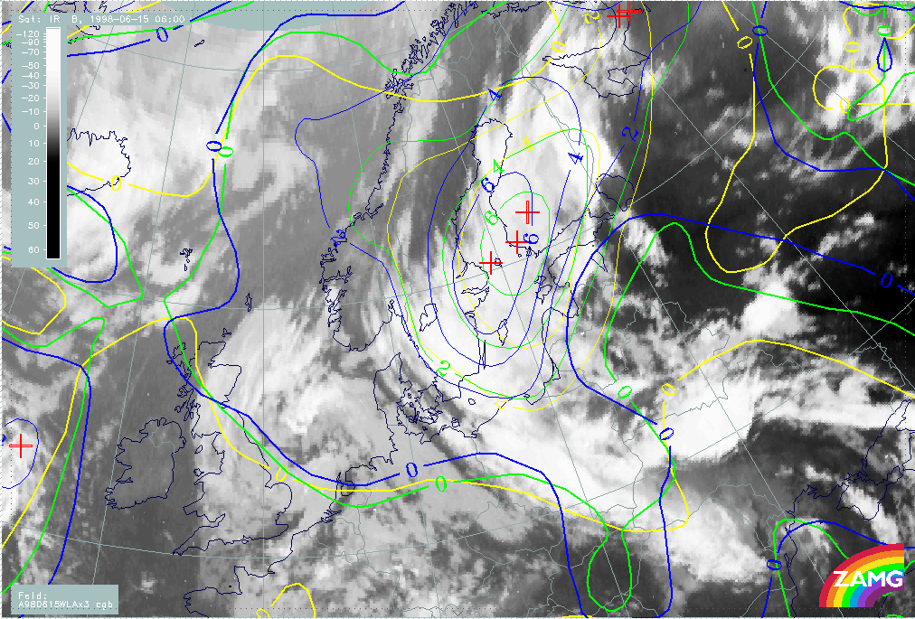
Following the development of the frontal system over Eastern Europe we now look at NWP-fields from 06.00, 12.00 and 18.00 UTC on the 15th of June. In Fig. H73 below, a rather slow west-northwest movement of the warm front TFP-zone can be seen over the next 12 hours, whilst the Cold Frontal TFP-zone moves rapidly northward.
|
15 June 1998/06.00 UTC - Meteosat IR image; yellow: thermal front parameter 500/850 hPa 06.00 UTC, green: thermal front parameter
500/850 hPa 12.00 UTC, blue: thermal front parameter 500/850 hPa 18.00 UTC
|
|
|
The temperature advection (H74) again follows TFP indications. The WA maximum remains very distinct with slow westward movement and slight intensification.
|
15 June 1998/06.00 UTC - Meteosat IR image; yellow: temperature advection - WA 06.00 UTC, green: temperature advection - WA 12.00 UTC,
blue: temperature advection - WA 18.00 UTC
|
|
|
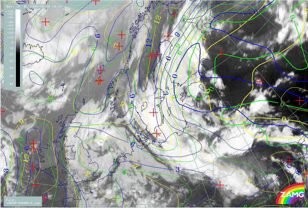
As above the Showalter index (H75) suggests a westward shifting of the Warm Front across Finland.
|
15 June 1998/06.00 UTC - Meteosat IR image; yellow: Showalter index 06.00 UTC, green: Showalter index 12.00 UTC, blue: Showalter index
18.00 UTC
|
|
|
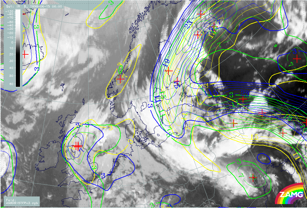
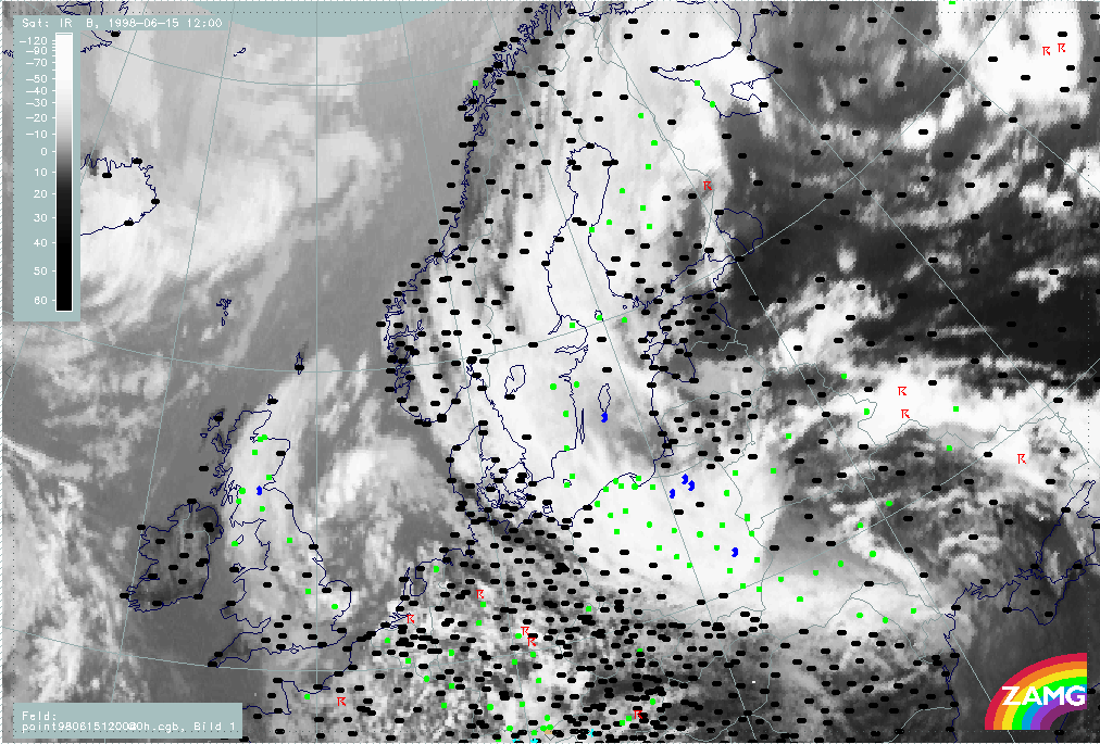
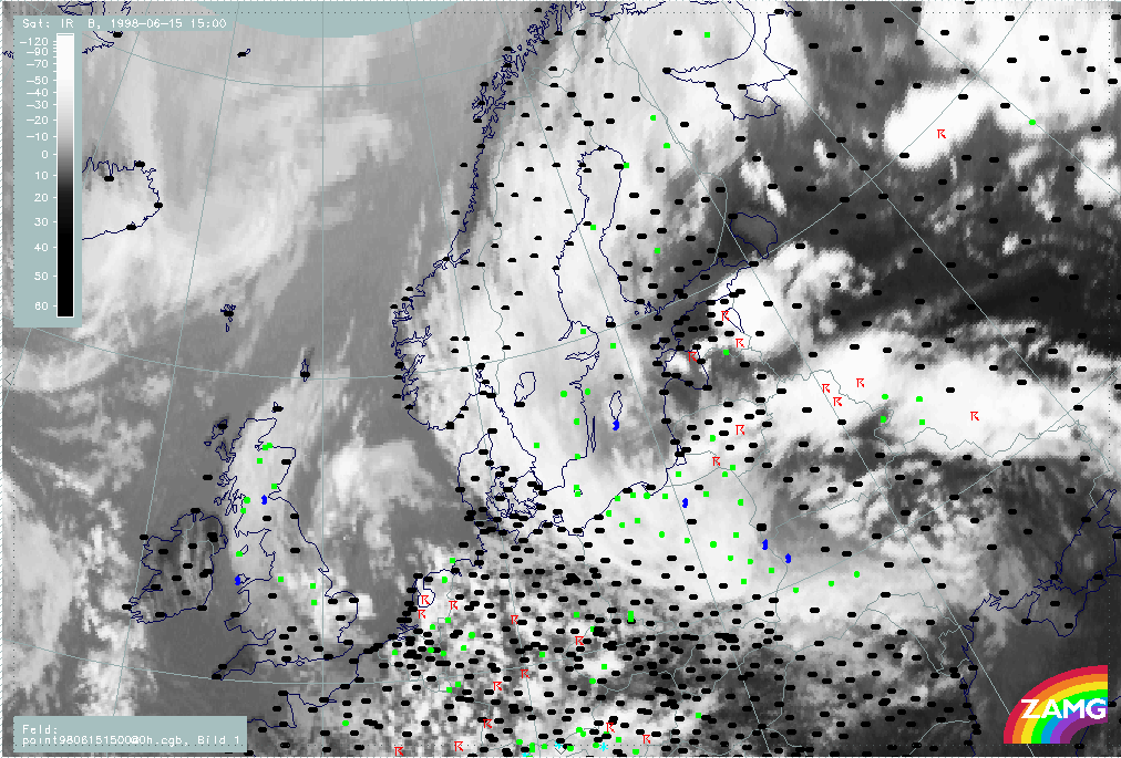
Overview of satellite features at the synoptic scale during the observation period
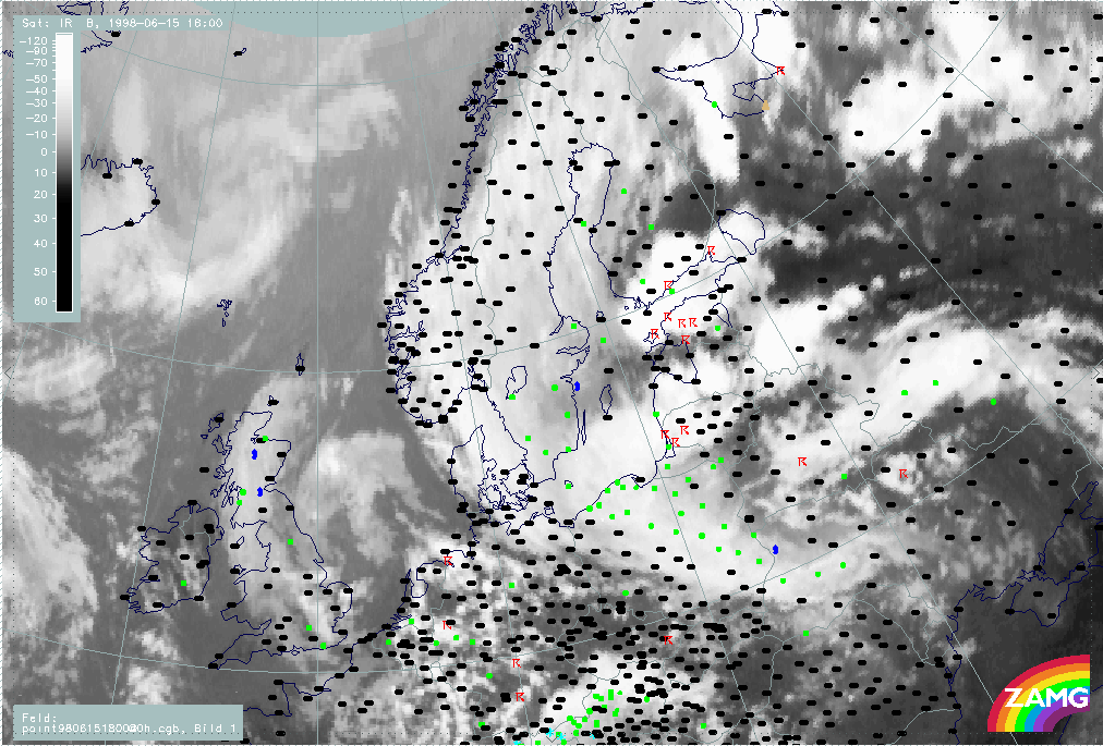
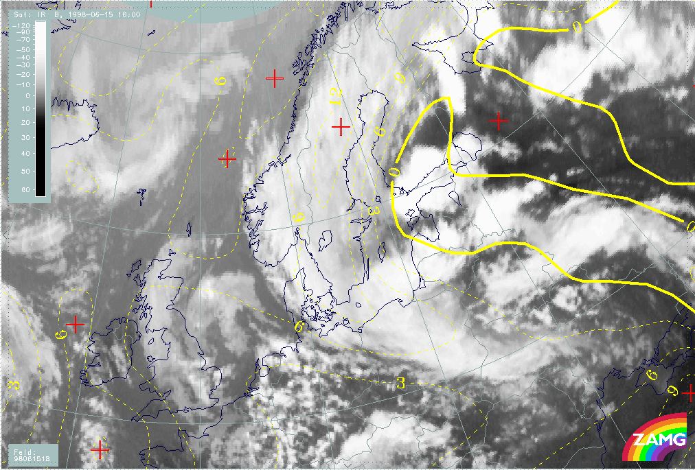
The following images (Fig. I00a-I00c) show the development of intensive MCS's, initially southeast of the Baltic States (56N/30E - 57N/36E) which, later in the evening, move towards Estonia and further over Finland. The large synoptic-scale frontal systems were located as follows:
- A Warm Front cloud band was located over Finland and Sweden, and it was accompanied by precipitation.
- A Cold Front cloud band was located over White Russia - Ukraine - Russia, and it was accompanied by rain and thunderstorms.
- A CCB Occlusion was located over Romania - Ukraine, and it was accompanied by precipitation.
The development of MCS's within the warm air-mass was rapid resulting in huge multiple MCS in southern Finland, Estonia and White Russia. Many thunderstorms were observed within these MCS's.
|
15 June 1998/12.00 UTC - Meteosat IR image; weather events (green: rain and showers, blue: drizzle, cyan: snow, red: thunderstorm with
precipitation, purple: freezing rain, orange: hail, black: no actual precipitation or thunderstorm with precipitation)
|
15 June 1998/15.00 UTC - Meteosat IR image; weather events (green: rain and showers, blue: drizzle, cyan: snow, red: thunderstorm with
precipitation, purple: freezing rain, orange: hail, black: no actual precipitation or thunderstorm with precipitation)
|
|
|
|
|
|
15 June 1998/18.00 UTC - Meteosat IR image; weather events (green: rain and showers, blue: drizzle, cyan: snow, red: thunderstorm with
precipitation, purple: freezing rain, orange: hail, black: no actual precipitation or thunderstorm with precipitation)
|
|
The observational part of MCS diagnosis - IR image sequence
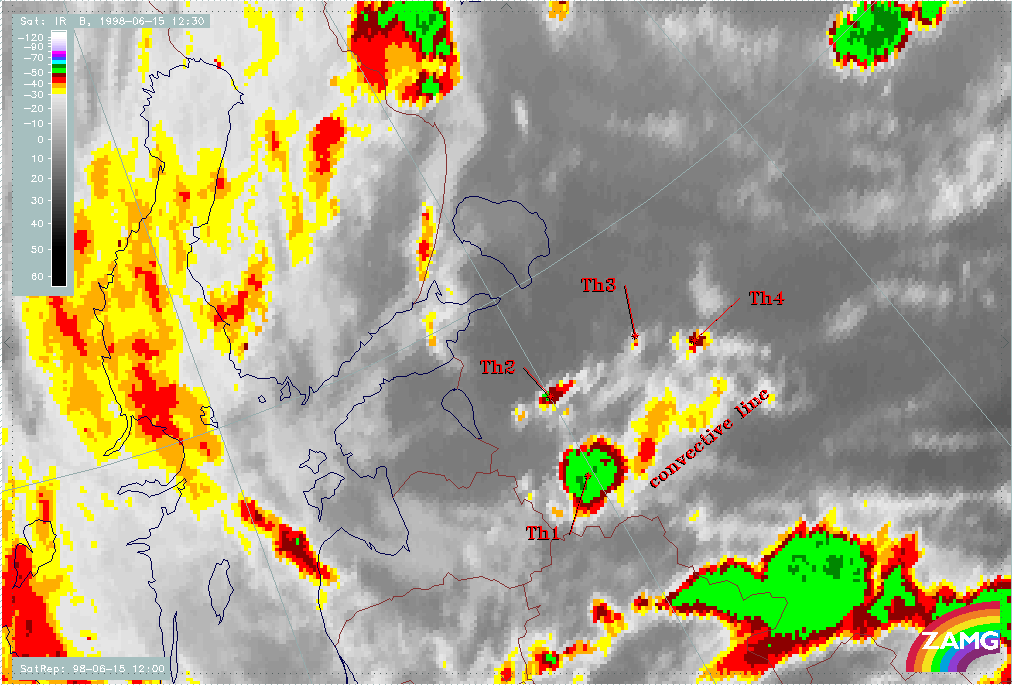
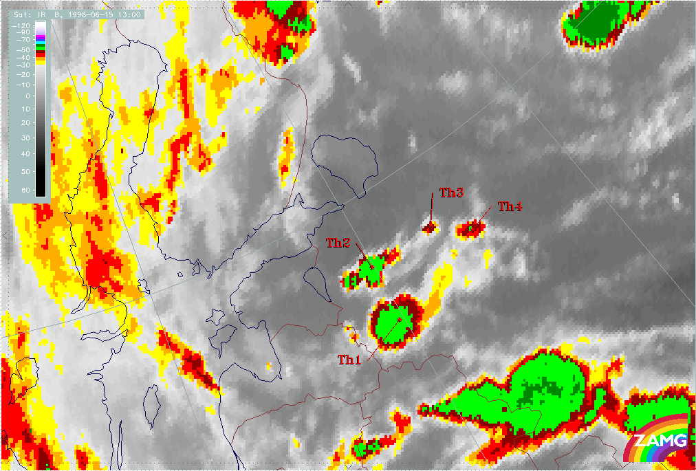
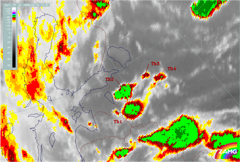
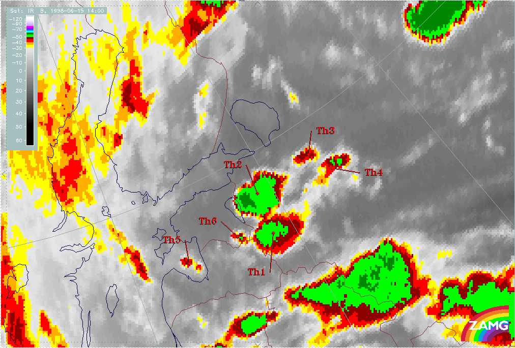
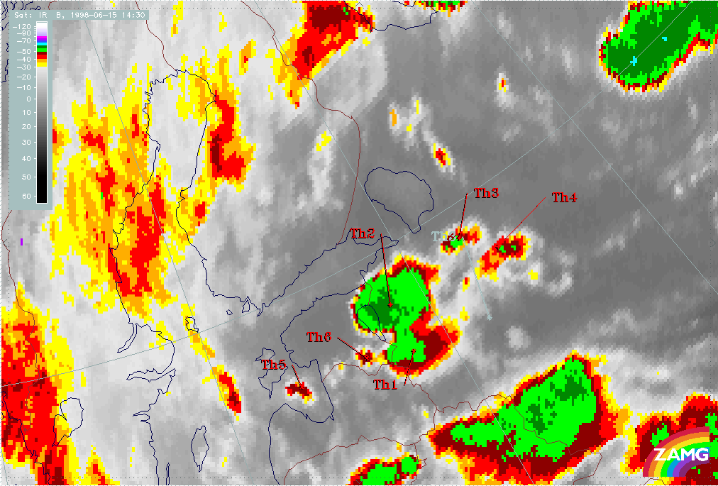
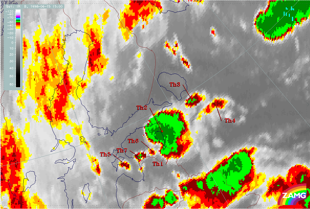
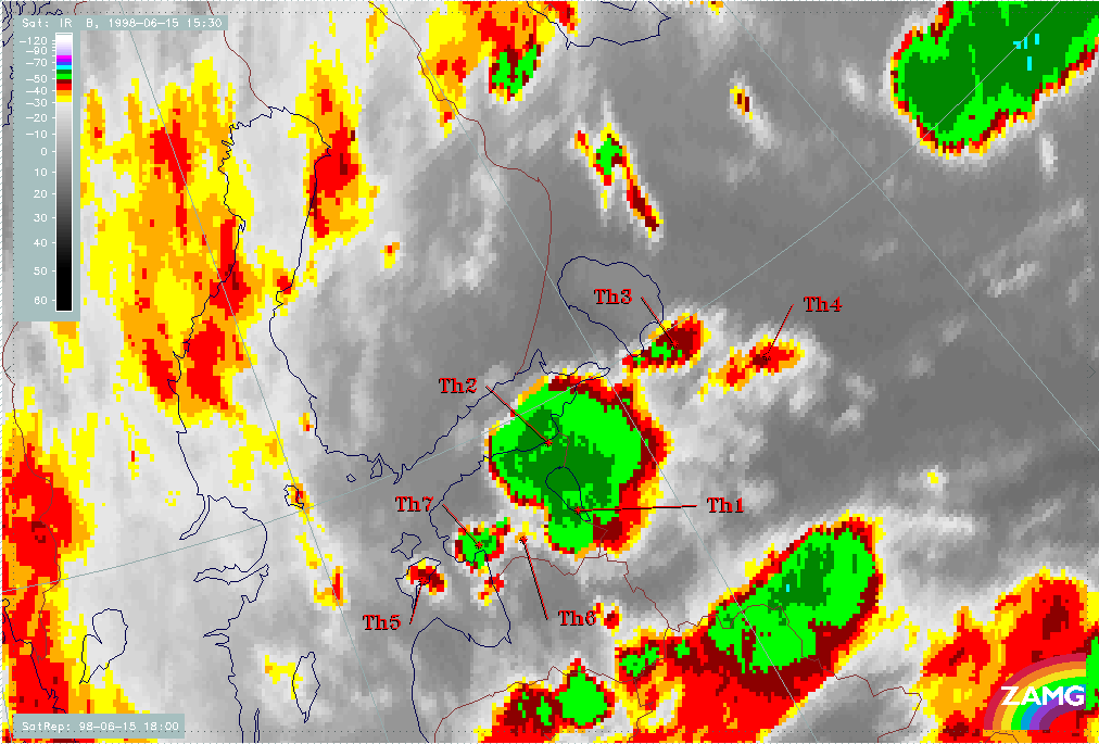
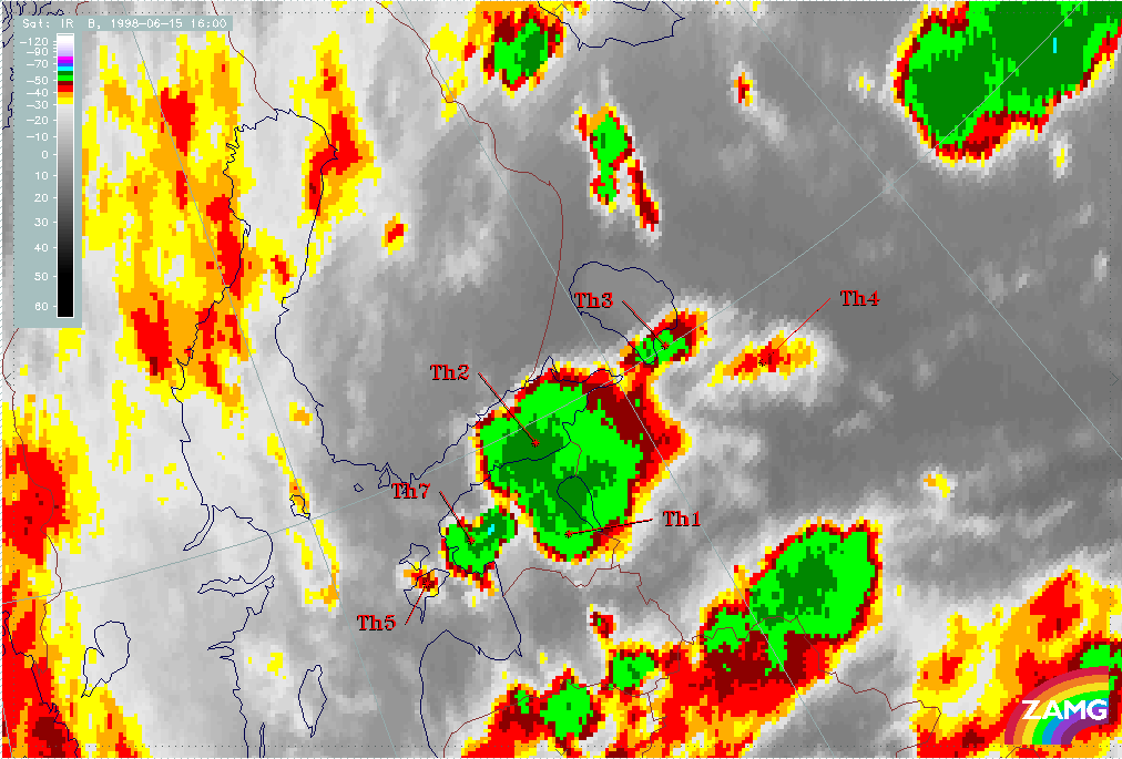
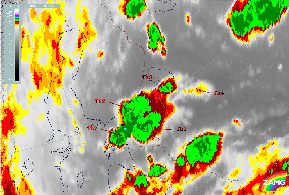
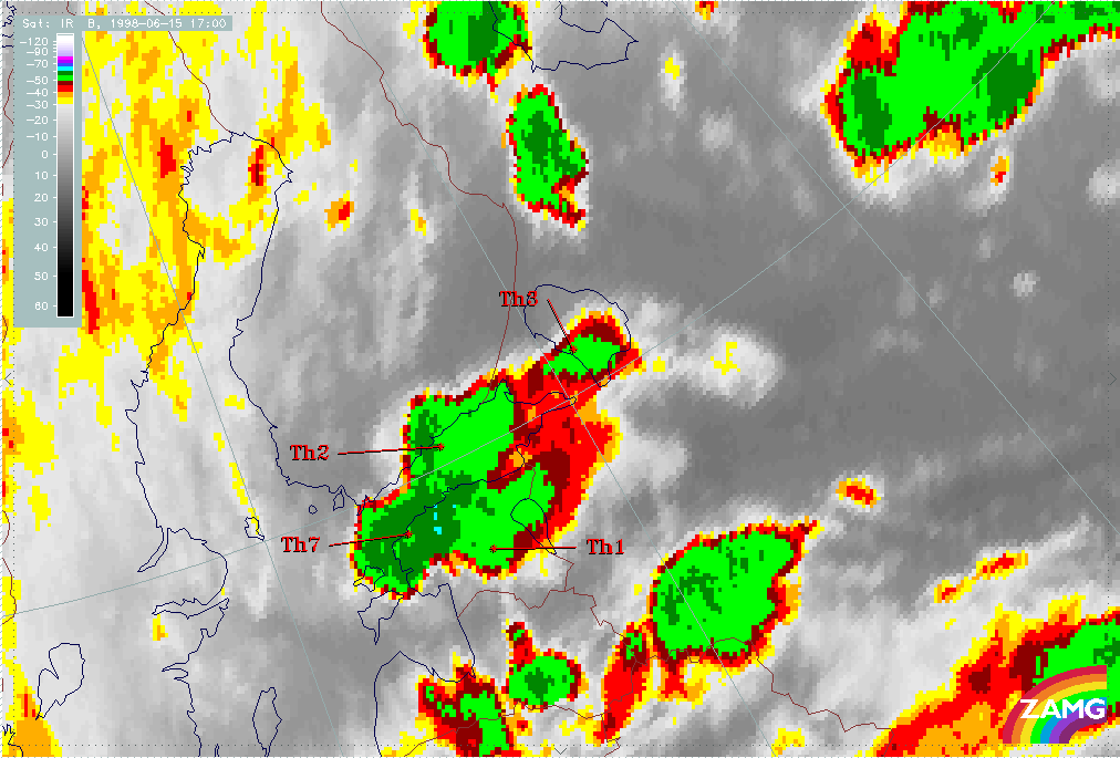
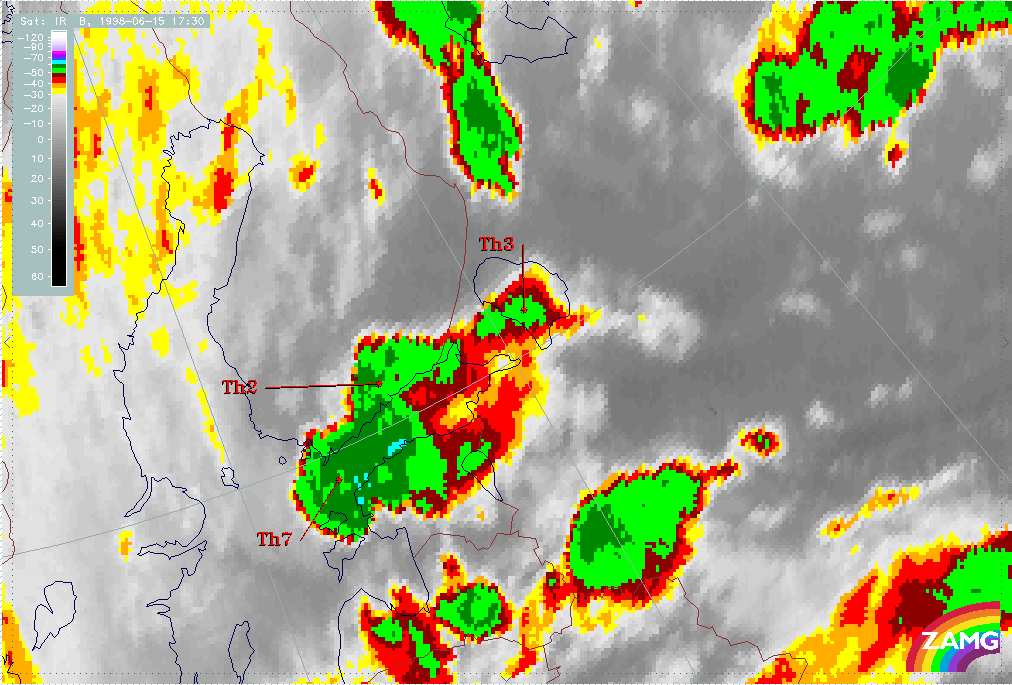
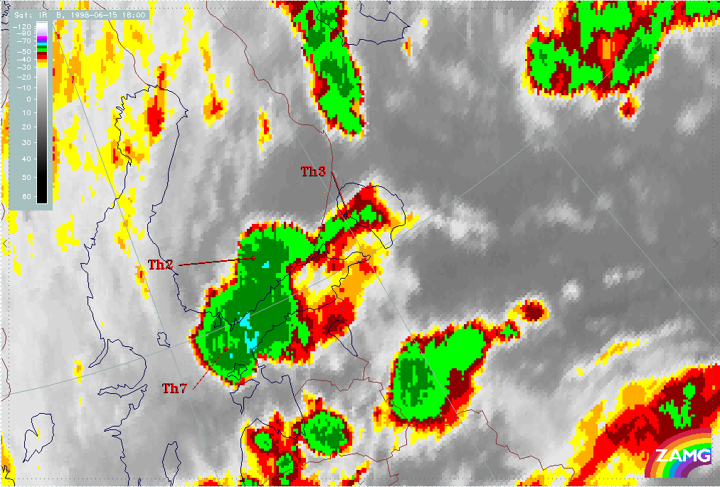
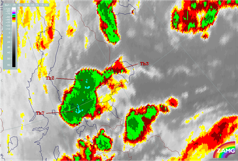
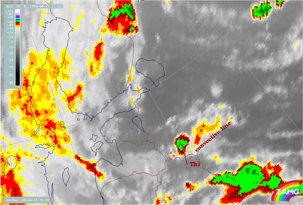
The following image sequence shows the rapid development of convective cells in half-hourly steps.
At 12.00 UTC the convective center (marked with Th1) is located along a west-east oriented convective line, which seemingly decays by 12.30
UTC. Meanwhile a new development can be seen ahead of the line (possibly within the gust front initiated by Th1). The new colder tops are
marked as Th2, Th3, Th4.
During the next few hours Th1 does not develop any further, whilst Th2 develops very quickly. The merging of Th1 and Th2 takes place around
14.30 UTC. Th1 remains, however, still recognizable for couple of hours as a part of the huge, merged Th1-Th2 MCS cloud over Estonia and Gulf
of Finland.
By 15.00 UTC new Cb cells have developed, and now seven distinct convective centers can be detected, although most of them are only small in
size.
The spreading of the cirrus anvils of the individual cells results in merging of upper-level clouds, which can be seen very clearly in the
images for 18.00 or 18.30 UTC. At that time there is practically only one huge and intensive MCS cell over southern Finland.
|
15 June 1998/12.00 UTC - Meteosat IR enhanced image; 12.00 - 18.30 UTC half-hourly image Loop
|
15 June 1998/12.30 UTC - Meteosat IR enhanced image
|
|
|
|
|
|
15 June 1998/13.00 UTC - Meteosat IR enhanced image
|
15 June 1998/13.30 UTC - Meteosat IR enhanced image
|
|
15 June 1998/14.00 UTC - Meteosat IR enhanced image
|
15 June 1998/14.30 UTC - Meteosat IR enhanced image
|
|
|
|
|
|
15 June 1998/15.00 UTC - Meteosat IR enhanced image
|
15 June 1998/15.30 UTC - Meteosat IR enhanced image
|
|
15 June 1998/16.00 UTC - Meteosat IR enhanced image
|
15 June 1998/16.30 UTC - Meteosat IR enhanced image
|
|
|
|
|
|
15 June 1998/17.00 UTC - Meteosat IR enhanced image
|
15 June 1998/17.30 UTC - Meteosat IR enhanced image
|
|
15 June 1998/18.00 UTC - Meteosat IR enhanced image
|
15 June 1998/18.30 UTC - Meteosat IR enhanced image
|
|
|
The synoptic environment part of MCS diagnosis - 15 June/12.00 and 18.00 UTC
A brief description of the synoptic environments associated with the MCS is given below.
Showalter index
Fig. MC01 shows that the area under consideration at 12.00 UTC is under the influence of Showalter index <3 units. However, this was not the case in the area where the MCS's initially developed. By 18.00 UTC (MC02) low (below 0) the Showalter index extends along the Cold Front and fits much better with the observed convectively active areas.
|
15 June 1998/12.00 UTC - Meteosat IR image; yellow: Showalter index
|
15 June 1998/18.00 UTC - Meteosat IR image; yellow: Showalter index
|
|
|
ThetaE 850 hPa
An analysis of ThetaE at 850 hPa provides better correlation with the location of initial MCS development.
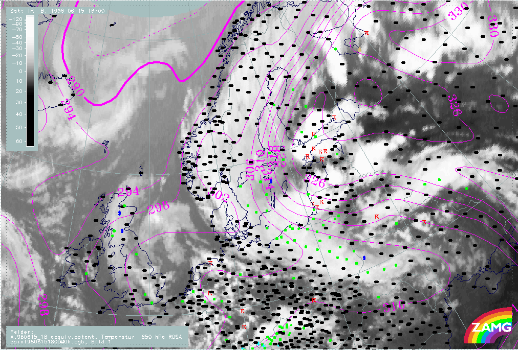
At 12.00 UTC (Fig. MC03) the area of development appears to be very close to the area of maximum ThetaE values (322K); a tongue of high ThetaE
values are advected from the southeast towards the northeast. At 18.00 UTC (Fig. MC04) this tongue of high ThetaE values is even more evident,
very high values extending up into central Finland. The isoline of ThetaE of 326K coincides remarkably well with the northern boundary of the
MCS.
|
15 June 1998/12.00 UTC - Meteosat IR image; ThetaE 850 hPa, weather events (green: rain and showers, blue: drizzle, cyan: snow, red:
thunderstorm with precipitation, purple: freezing rain, orange: hail, black: no actual precipitation or thunderstorm with precipitation)
|
15 June 1998/18.00 UTC - Meteosat IR image; ThetaE 850 hPa, weather events (green: rain and showers, blue: drizzle, cyan: snow, red:
thunderstorm with precipitation, purple: freezing rain, orange: hail, black: no actual precipitation or thunderstorm with precipitation)
|
|
|
Frontal parameters and temperature advection
TFP and warm advection chart (Fig. MC05) shows the location of MCS's in respect to the approaching cold front from the south. The MCS are ideally located - just before the actual Cold Front, but clearly as separate cloud. At 12.00 UTC the young MCS seems to be located within zero temperature advection, but later in the evening they move towards an area of advection and catch up with the the Warm Front cloud band.
|
15 June 1998/12.00 UTC - Meteosat IR image; blue: thermal front parameter (TFP) 500/850 hPa, green: equivalent thickness 500/850 hPa,
red: temperature advection - WA
|
15 June 1998/18.00 UTC - Meteosat IR image; blue: thermal front parameter (TFP) 500/850 hPa, green: equivalent thickness 500/850 hPa,
red: temperature advection - WA
|
|
|
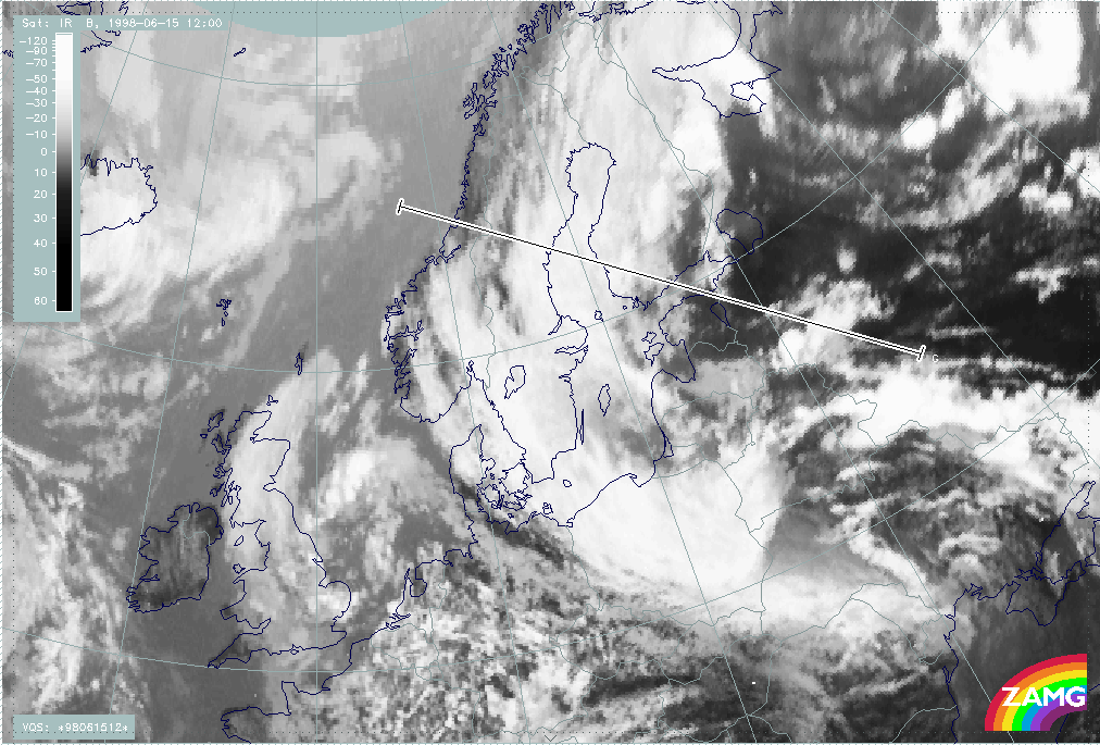
Vertical Cross sections
The vertical cross sections shown below are oriented from east to west. The exact location of the cross section is shown in Fig. MC07. Only 12.00 UTC cross sections are shown; cross sections at 18.00 UTC are very similar.
|
15 June 1998/12.00 UTC - Meteosat IR image; position of vertical cross section indicated
|
|
|
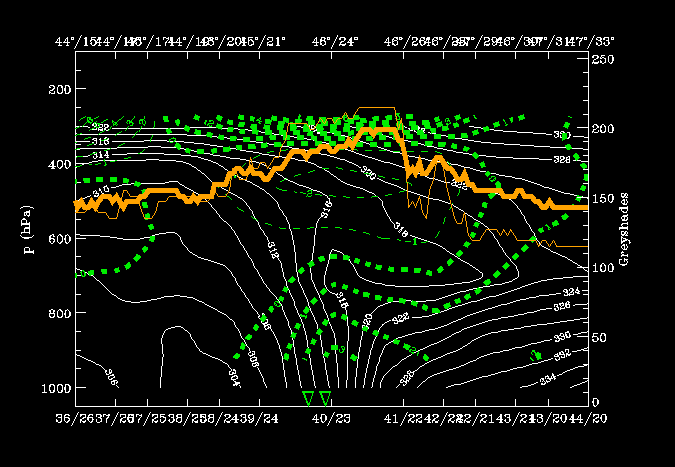
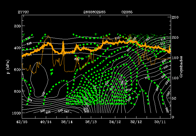
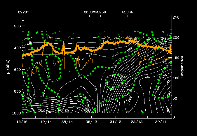
Easternmost (leftmost) peak in IR pixel counts corresponds to convective clouds associated with developing MCS; the air mass appears to be
potentially unstable throughout a deep layer above the ground (up to 500 hPa). MCS's are in an area of weak warm advection (MC08). The cross
section shows the typical characteristics of a Warm Front Band with only weak temperature advection within.
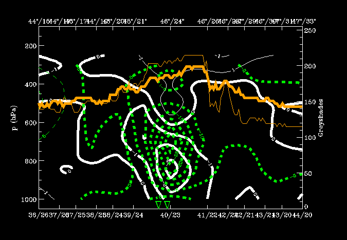
The distribution of convergence (Fig. MC09) is less typical, because convergence is found only in middle layers, not in lower layers.
PVA (Fig. MC10) appears to have no impact on the development of MCS.
|
15 June 1998/12.00 UTC - Vertical cross section; white: isentropes (ThetaE), green thin: temperature advection - CA, green thick:
temperature advection - WA, orange thin: IR pixel values, orange thick: WV pixel values
|
15 June 1998/12.00 UTC - Vertical cross section; white: isentropes (ThetaE), green thin: divergence, green thick: convergence, orange
thin: IR pixel values, orange thick: WV pixel values
|
|
|
|
|
|
15 June 1998/12.00 UTC - Vertical cross section; white: isentropes (ThetaE), green thick: vorticity advection - PVA, green thin:
vorticity advection - NVA, orange thin: IR pixel values, orange thick: WV pixel values
|
|
Conclusions
The case study describes a typical summertime development, the western part of Europe may be under an extensive Upper Level Low or trough with unstable and cool weather, while an extensive area of high pressure is centered over Russia giving very warm and dry weather for eastern Europe. A baroclinic zone with considerable temperature gradient and instability may develop between these two air-masses.
In this case study the baroclinic zone extended from the Black Sea up to eastern parts of Scandinavia. A wave disturbance formed within the baroclinic zone. An asssociated low pressure centre moved northwards from the Black Sea. Warm and Cold Fronts brought precipitation, which was more continuous on the western (cooler) side of the Wave, and more convective on the eastern (warmer and more unstable) side of the Wave.
Warm Front cloudiness had a distinct band character, as the air in the warm sector was originally relatively dry. An appreciable amount of potential instability was released as a result of afternoon heating over western Russia, which resulted in very quick development of Cb cells and MCS's over an extensive area. The location of MCS's matched the location of maximum ThetaE at 850 hPa very closely. The mature MCS brought intense thunderstorms, gusty winds and rain to the Baltic States and to southern Finland later in the evening.