Table of Contents
- I. 15 March 06.00 UTC
- 06.00 UTC - Overview of satellite imagery
- 06.00 UTC - Key parameters on isobaric surfaces
- 06.00 UTC - Frontal Diagnosis - Use of vertical cross sections
- 06.00 UTC - Frontal Diagnosis - Relative streams and conveyor belts
- Very Short Range Forecast 06.00 - 18.00 UTC
- II. 15 March 09.00 - 12.00 UTC
- 09.00 - 12.00 UTC - Overview of satellite imagery
- 09.00 - 12.00 UTC - Key parameters on isobaric surfaces
- 09.00 - 12.00 UTC - Frontal Diagnosis - Use of vertical cross sections
- 09.00 - 12.00 UTC - Frontal Diagnosis - Relative streams and conveyor belts
- III. 15 March 15.00 - 18.00 UTC
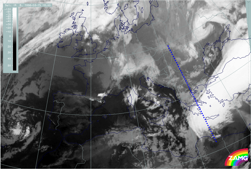
- 15.00 - 18.00 UTC - Overview of satellite imagery
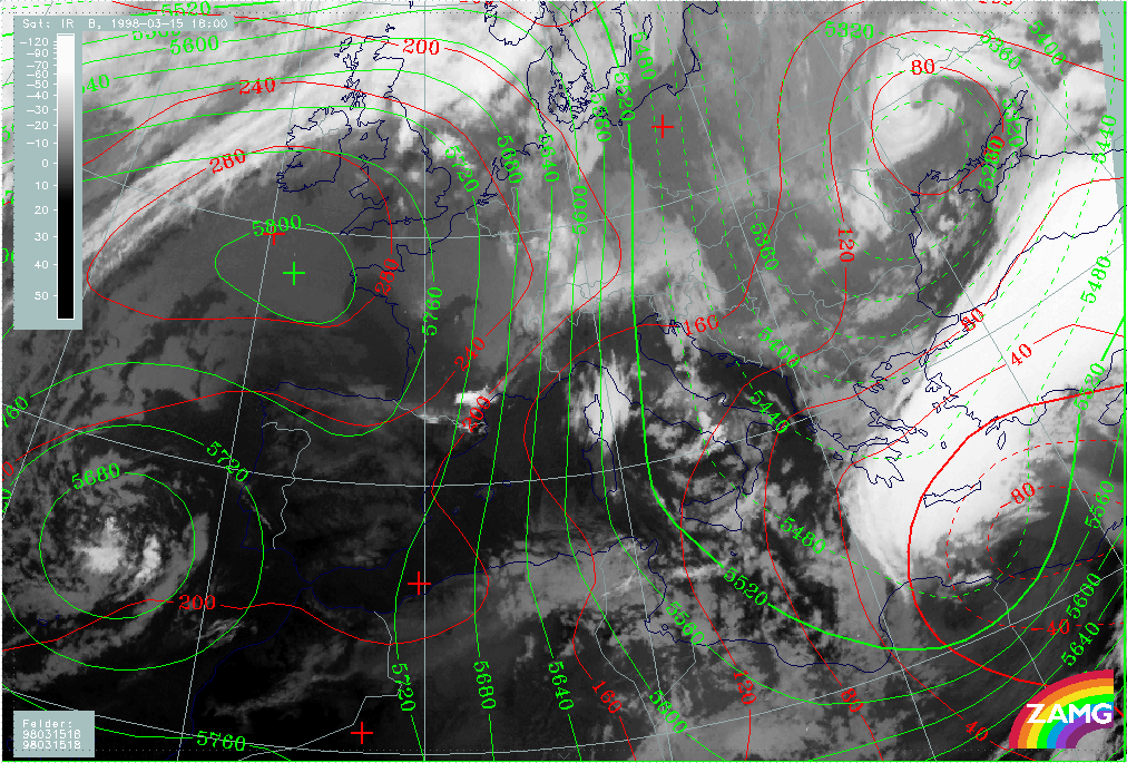
- 15.00 - 18.00 UTC - Key parameters on isobaric surfaces
- 15.00 - 18.00 UTC - Frontal Diagnosis - Use of vertical cross sections
- 15.00 - 18.00 UTC - Frontal Diagnosis - Relative streams and conveyor belts
- IV. 15 March 21.00 UTC - 16 March 00.00 UTC
- 15/21.00 - 16/00.00 UTC - Overview of satellite imagery
- 15/21.00 - 16/00.00 UTC - Key parameters on isobaric surfaces
- 15/21.00 - 16/00.00 UTC - Frontal Diagnosis - Use of vertical cross sections
- 15/21.00 - 16/00.00 UTC - Frontal Diagnosis - Relative streams and conveyor belts
- V. 16 March 03.00 - 06.00 UTC
- 03.00 - 06.00 UTC - Overview of satellite imagery
- 03.00 - 06.00 UTC - Comma Diagnosis - Key parameters on isobaric surfaces
- 03.00 - 06.00 UTC - Comma Diagnosis - Use of vertical cross sections
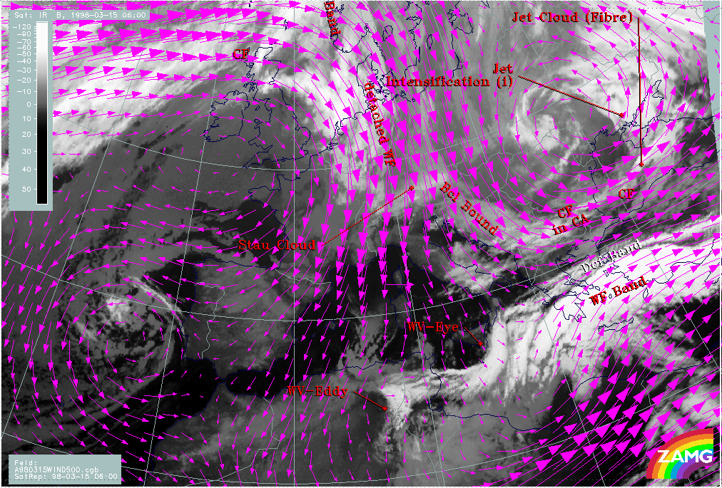
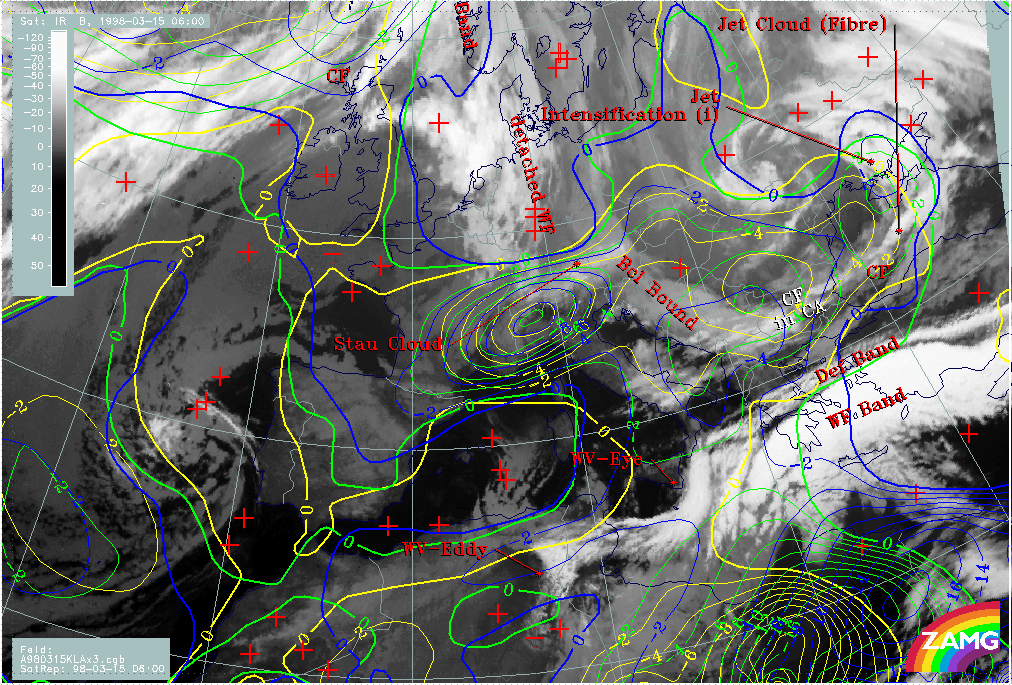
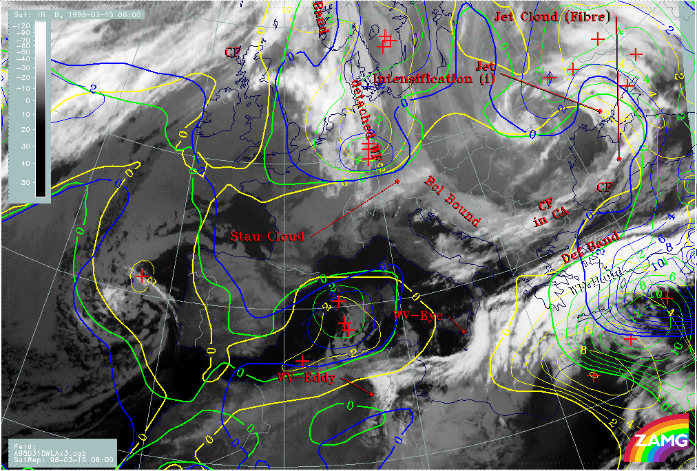
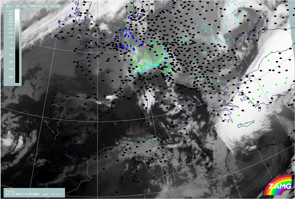
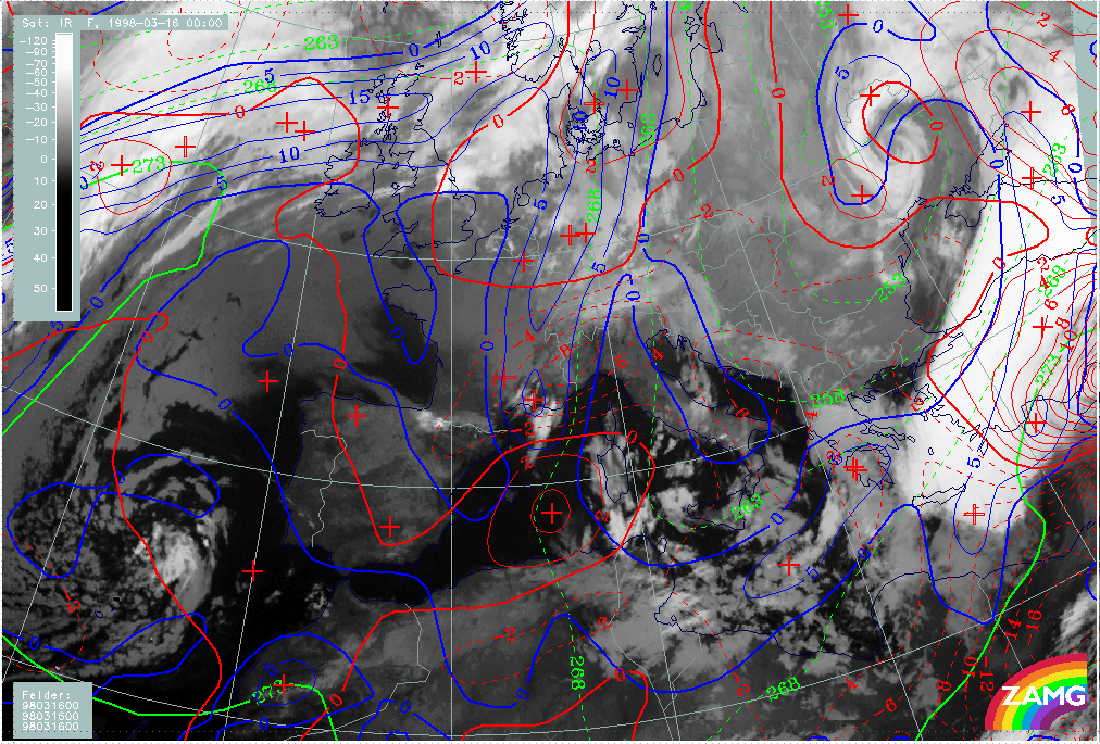
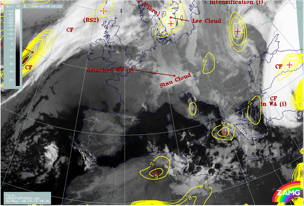
06.00 UTC - Overview of satellite imagery
|
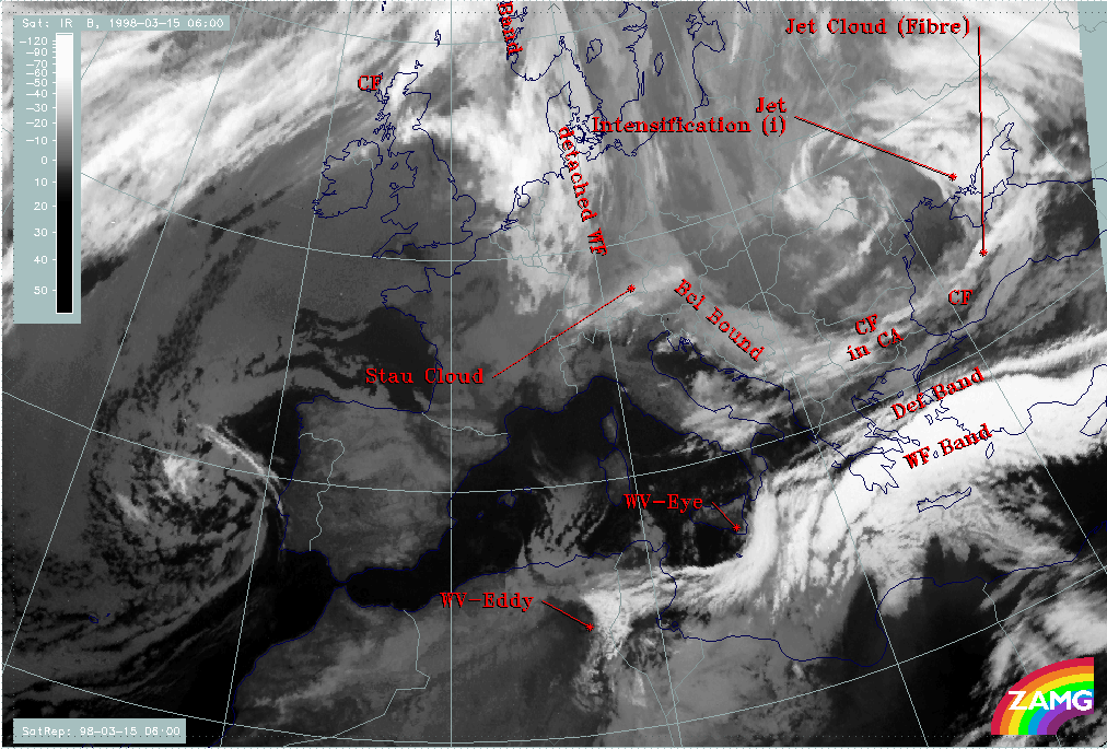
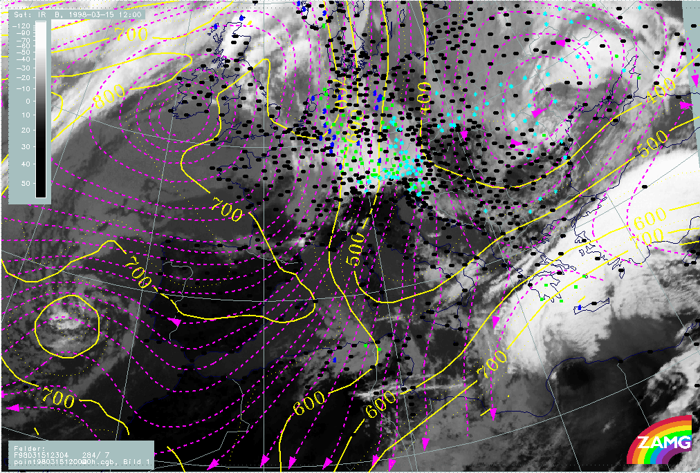
15 March 1998/06.00 UTC - Meteosat IR image; SatRep overlay: names of conceptual models
|
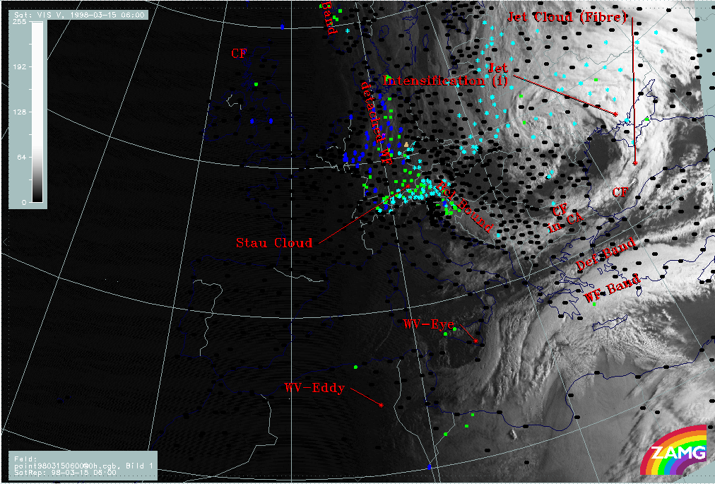
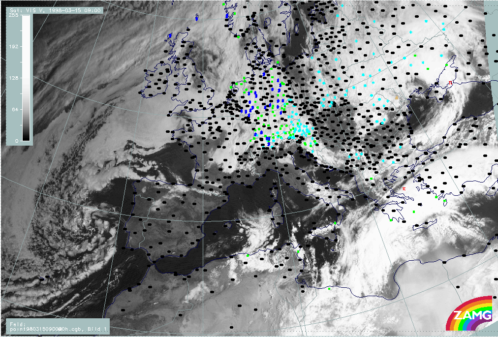
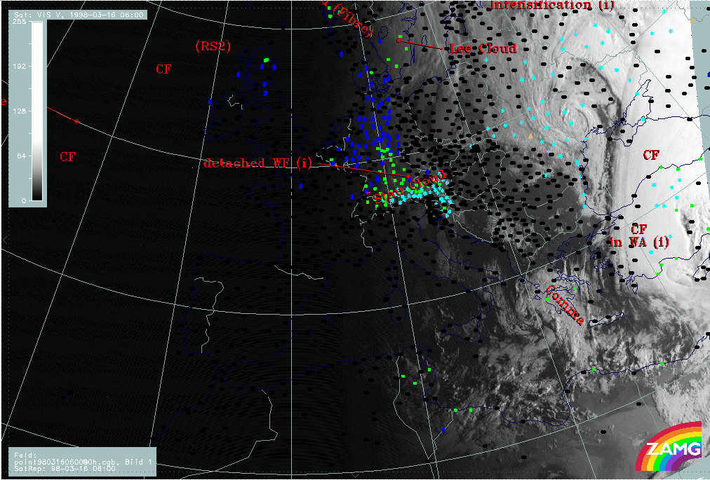
15 March 1998/06.00 UTC - Meteosat VIS image; weather events (green: rain and showers, blue: drizzle, cyan: snow, red: thunderstorm
with precipitation, purple: freezing rain, orange: hail, black: no actual precipitation or thunderstorm with precipitation), SatRep
overlay: names of conceptual models
|
|
|
|
|
|
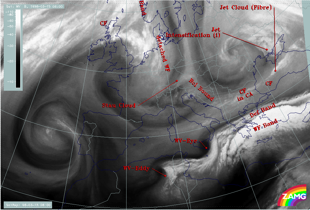
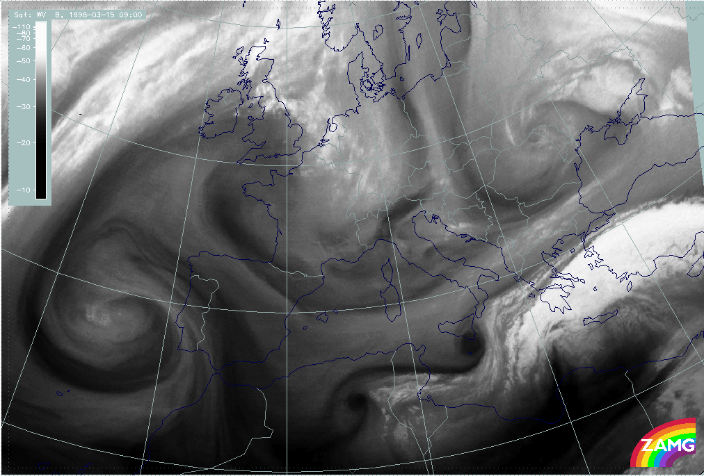
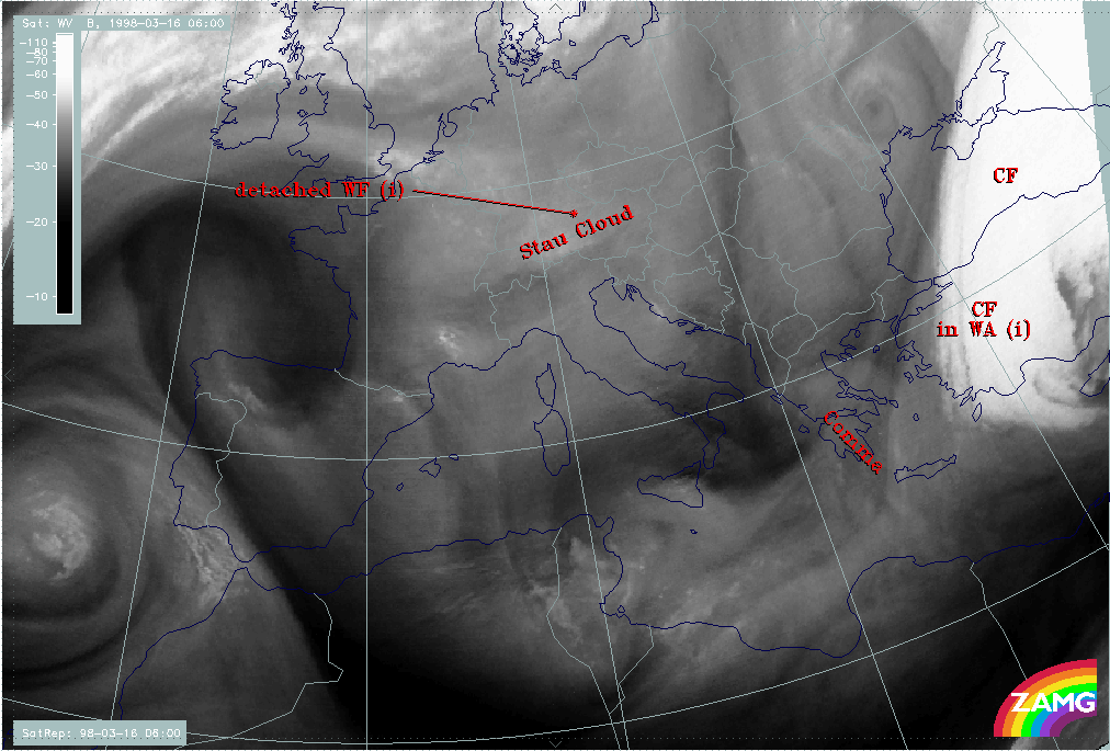
15 March 1998/06.00 UTC - Meteosat WV image; SatRep overlay: names of conceptual models
|
|
The names of conceptual models superimposed on the cloud systems in the satellite images in all three channels demonstrate the synoptic situation. According to the topic of this case study the main area of interest is the Balkan Peninsula and the eastern Mediterranean with special respect to Greece, the Aegean Sea and Turkey. The most important conceptual models involved are:
- A cloud band extending from Bulgaria across the Black Sea to the Ukraine; it accompanies a Cold Front (CF) which is to a big extent under the influence of cold advection (CA) (compare Conceptual Models: Cold Front );
- There is an area where the frontal cloudiness is intensified (Jet Intensification) by the crossing of a jet streak; this intensification happens in the left exit region of the jet streak (compare Conceptual Models: Front Intensification by Jet Crossing );
- A bright cloud band in the Mediterranean accompanying a Warm Front Band (WF band); there is some precipitation connected with the Warm Front Band in the Aegean Sea; no distinct cloud features of a Cold Front related to the Warm Front can be extracted (compare Conceptual Models: Warm Front Band );
- A narrow fibrous band named Deformation Band (DEF Band); extends parallel to the northern boundary of the Warm Front (compare Conceptual Models: Deformation Band );
- Two structures best seen in the WV image are named Water Vapour Eye (WV - Eye) and Water Vapour Eddy (WV - Eddy); they are represented by black, very dry circular features (compare Conceptual Models: Water Vapour Vortices ).
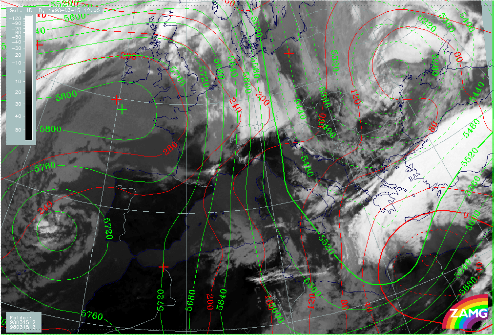
06.00 UTC - Key parameters on isobaric surfaces
|
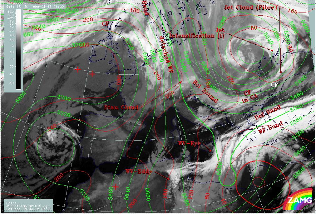
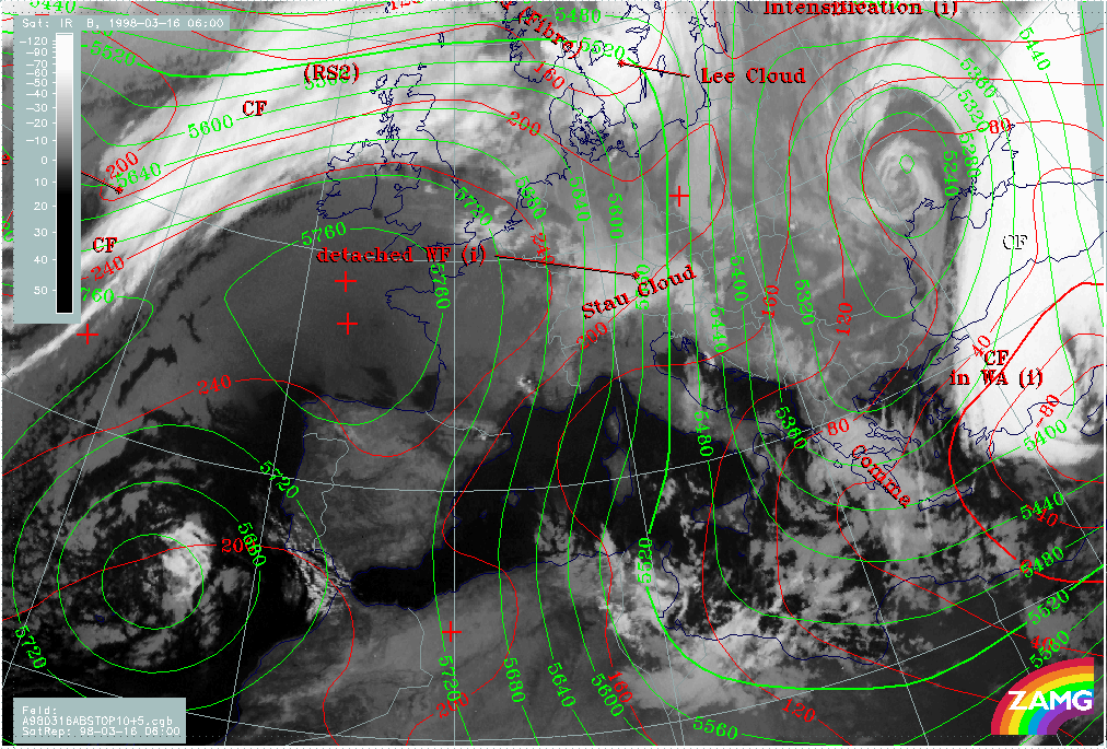
15 March 1998/06.00 UTC - Meteosat IR image; red: height contours 1000 hPa, green: height contours 500 hPa, SatRep overlay: names of
conceptual models
|
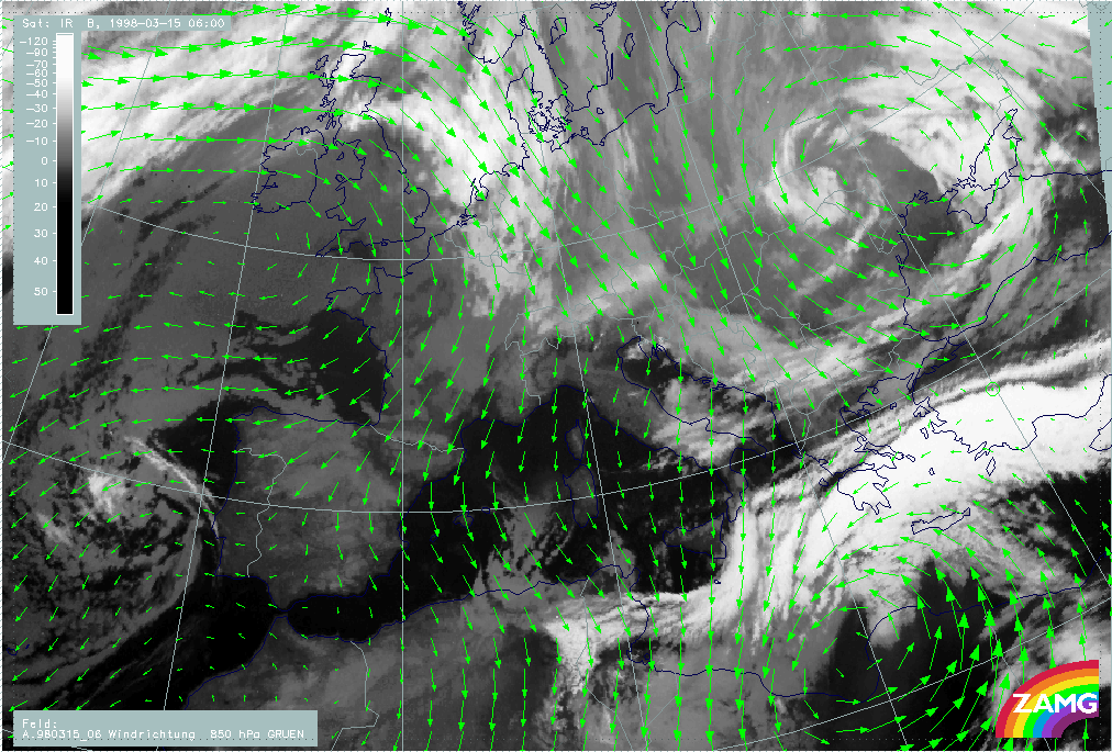
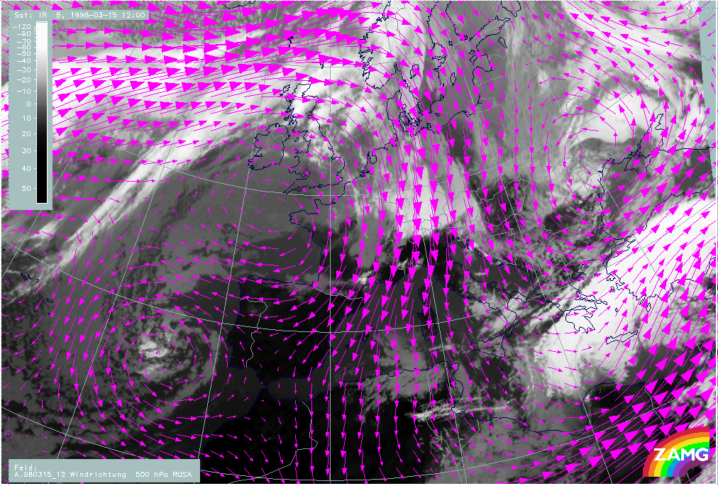
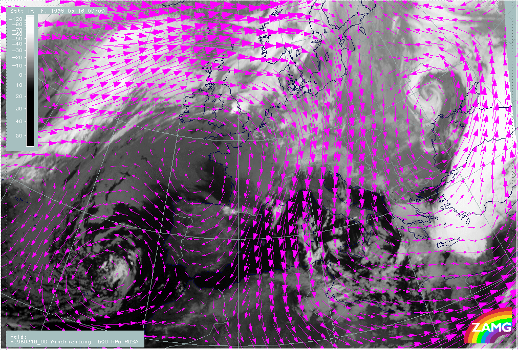
15 March 1998/06.00 UTC - Meteosat IR image; magenta: wind vectors 500 hPa, SatRep overlay: names of conceptual models
|
|
|
|
|
|
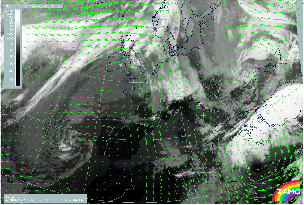
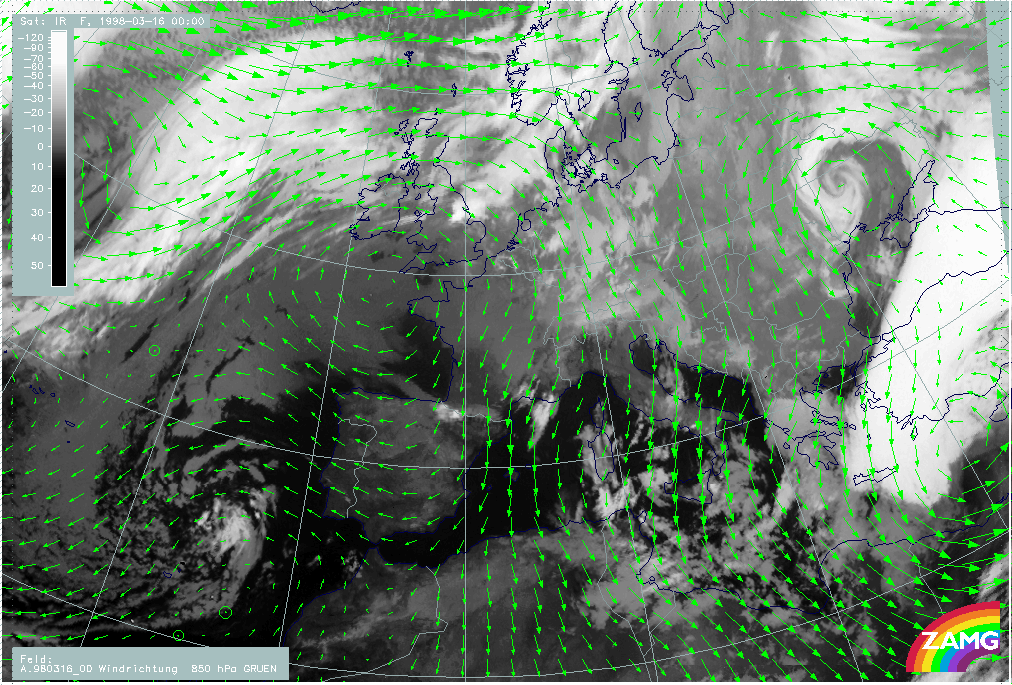
15 March 1998/06.00 UTC - Meteosat WV image; green: wind vectors 850 hPa
|
|
The first image (left image top) represents surface and upper level height, the second image (right image top) and the third image (left image bottom) the wind vectors at 500 and 850 hPa. The main feature in the Mediterranean is a distinct surface low over north Africa with a well-developed upper level trough to the west of it. There are extended areas in the warm Front cloud band where the wind directions in low levels and those in high levels are opposite (south-eastward - south-westward components). Especially over the Aegean Sea there is a confluence zone at both levels but with completely different wind directions. This is exactly the area of the fibrous deformation cloud band which is elongated, especially in eastern directions.
The second area with an intensive cyclone is Romania and the Ukraine with a low centre developed throughout the whole troposphere and with a nearly vertical axis.
|
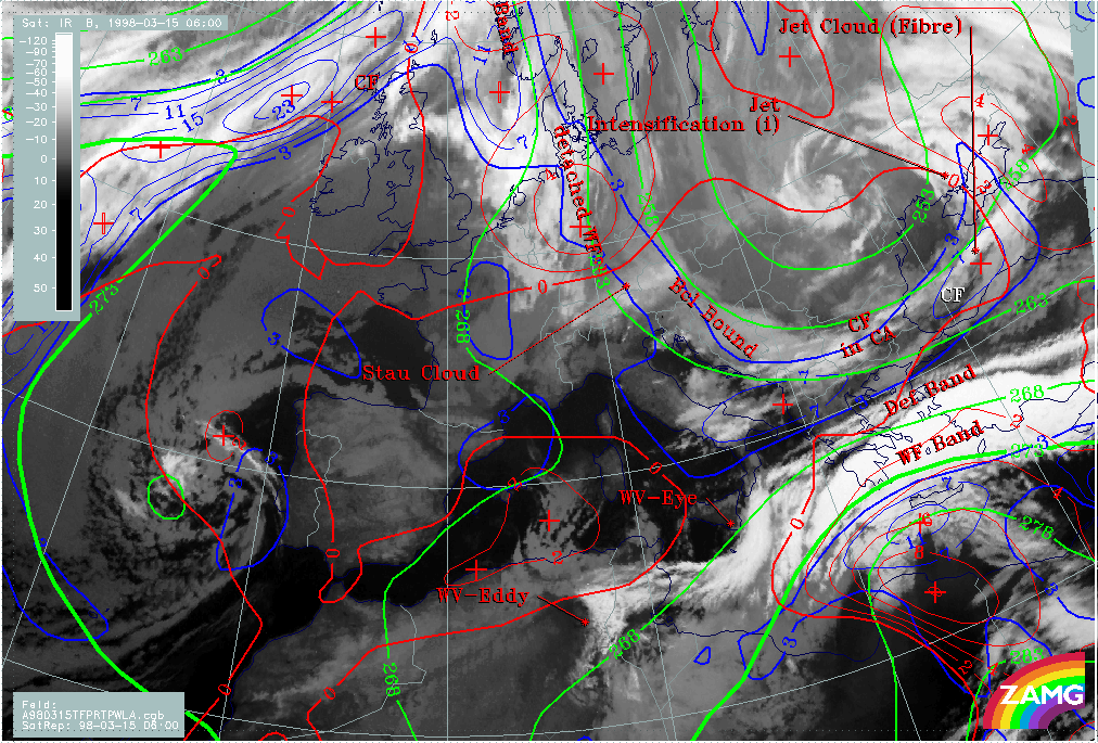
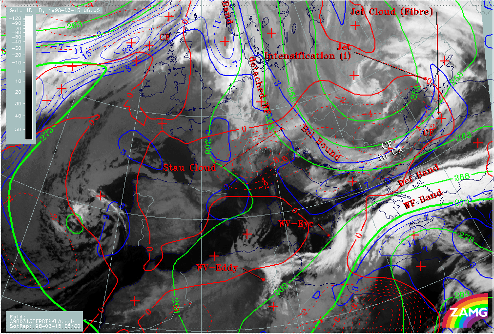
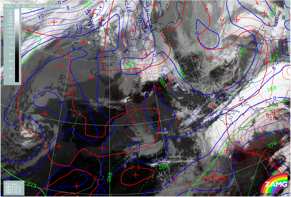
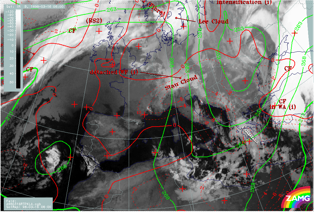
15 March 1998/06.00 UTC - Meteosat IR image; blue: thermal front parameter (TFP) 500/850 hPa, green: equivalent thickness 500/850 hPa,
red: temperature advection - WA 1000 hPa, SatRep overlay: names of conceptual models
|
15 March 1998/06.00 UTC - Meteosat IR image; blue: thermal front parameter (TFP) 500/850 hPa, green: equivalent thickness 500/850 hPa,
red: temperature advection - CA 1000 hPa, SatRep overlay: names of conceptual models
|
|
|
The frontal conditions are represented by three typical key parameters: thermal front parameter, equivalent thickness and temperature advection. There are two zones of high thickness gradients accompanying the frontal cloud bands: one in the Warm Front Band and a second within and north of the Cold Front across the Balkan Peninsula. The thermal front parameter TFP is in each of the two locations on the warm side of this thickness zones and at the leading edges of the cloud bands. Both frontal systems are well-developed, but the Cold Front in the north is under strong cold air advection (CA) (right image) with its minimum at the rear over Romania and Bulgaria, while the warm front in the south is in the boundary area of warm advection (WA) (left image).
The latter fact concerning the WA is rather untypical for Warm Fronts and confirms that this Mediterranean system is rather difficult to diagnose. This is especially true for a Cold Front diagnosis over the Mediterranean and north Africa. From the numerical parameters (compare also height levels) a Cold Front can be diagnosed over Africa crossing for instance 30N/22E with intensive WA at the leading side. But there is no reflection of such a frontal situation in the satellite imagery; on the contrary, this is a cloud-free area with very dry air in upper levels as can be seen in the WV image (image below). The cloud fields extending from the east of Crete south-eastward are situated on the warm boundary of the thickness ridge and do not represent a Cold Front there.
|
15 March 1998/06.00 UTC - Meteosat WV image; SatRep overlay: names of conceptual models
|
|
|
|
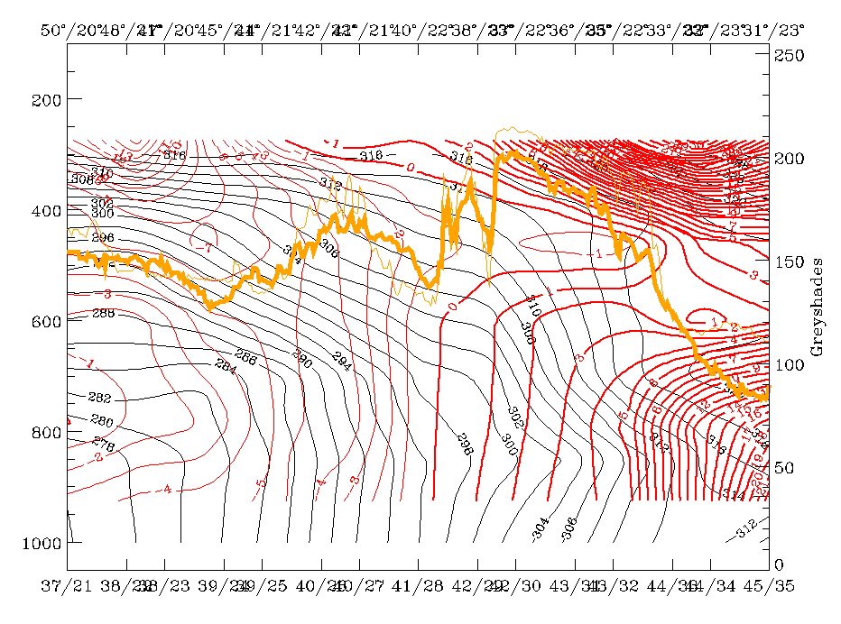
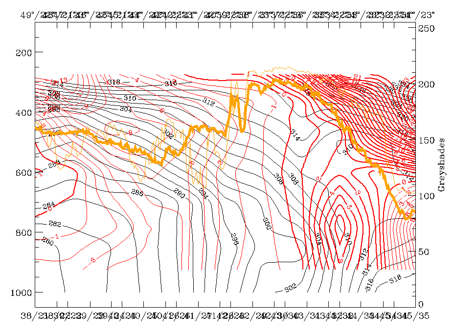
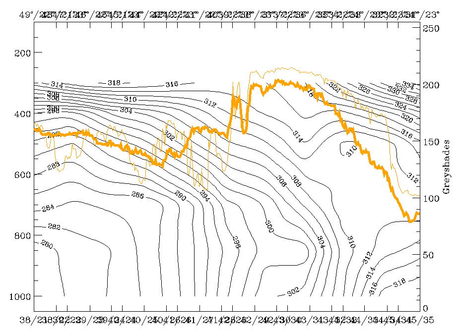
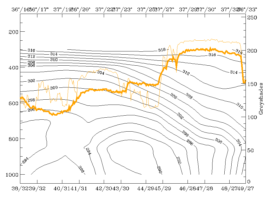
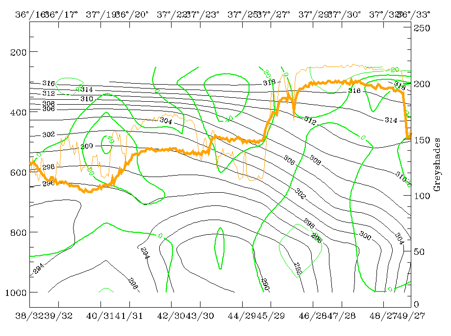
06.00 UTC - Frontal Diagnosis - Use of vertical cross sections
|
15 March 1998/06.00 UTC - Meteosat IR image; position of vertical cross section indicated
|
15 March 1998/06.00 UTC - Vertical cross section; black: isentropes (ThetaE), orange thin: IR pixel values, orange thick: WV pixel values
|

|

|
Vertical cross sections are a very useful tool for identifying and diagnosing synoptic systems such as fronts in respect to their quality and intensity. In the right image isentropes and satellite pixel values are used to characterize the synoptic situation for both frontal zones. The peak around 42N/22E corresponds to the Cold Front in Cold Advection, the small peak at 39N/21E to the deformation band and the broad peak between 39N/21E and 36N/23E to the Warm Front cloud band. Two frontal zones can be identified in the isentropes by downward inclined crowding zones, both of which reach the surface: the northern one at 42N/22E, the southern one at 33N/22E. The southern frontal zone shows superadiabatic behaviour from the surface up to 850 hPa.
|
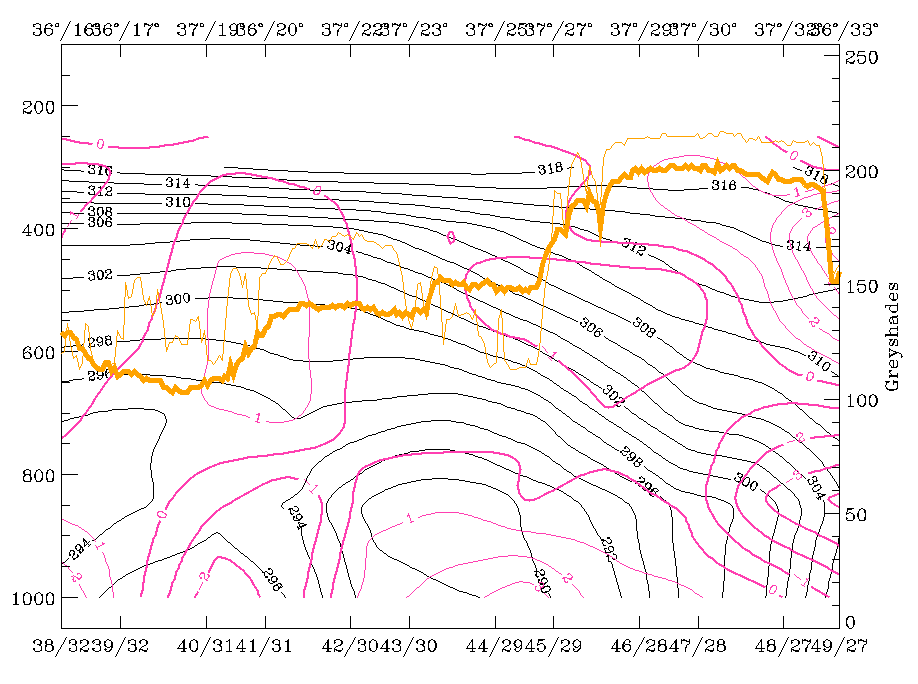
15 March 1998/06.00 UTC - Vertical cross section; black: isentropes (ThetaE), red thin: temperature advection - CA, red thick:
temperature advection - WA, orange thin: IR pixel values, orange thick: WV pixel values
|
|
|
Additionally, temperature advection is superimposed in the image above. Confirming what has already been diagnosed with help of the TA on isobaric surfaces, the vertical cross section shows that the northern zone is completely under the influence of CA with the strongest values below the isentropic crowding zone. The southern zone is under the influence of WA up to 500 hPa with WA within and in front of the frontal zone; this represents the upgliding warm air.
|
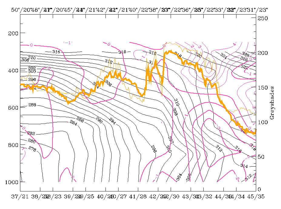
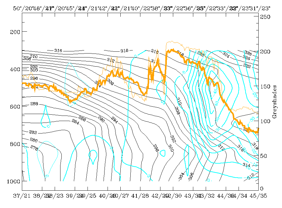
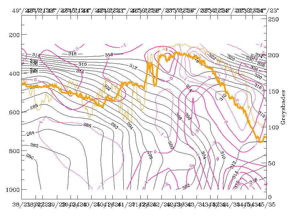
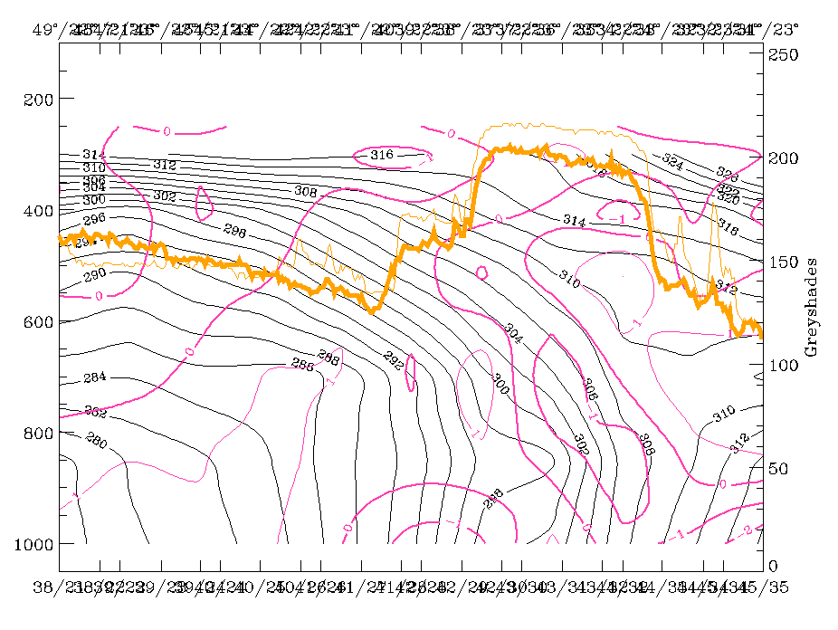
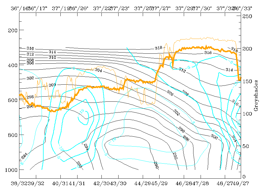
15 March 1998/06.00 UTC - Vertical cross section; black: isentropes (ThetaE), magenta thin: divergence, magenta thick: convergence,
orange thin: IR pixel values, orange thick: WV pixel values
|
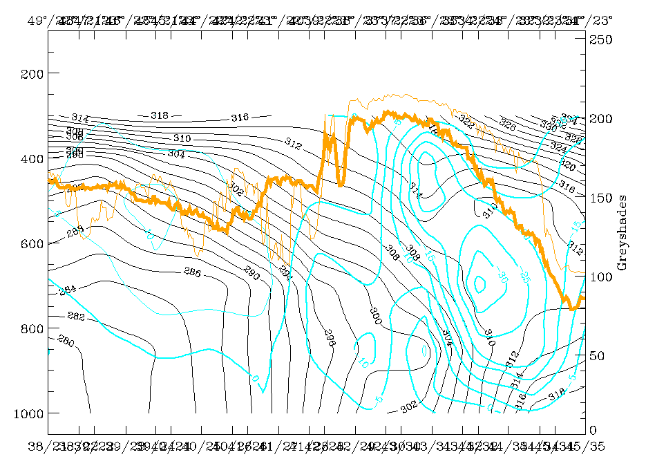
15 March 1998/06.00 UTC - Vertical cross section; black: isentropes (ThetaE), cyan thick: vertical motion (omega) - upward motion, cyan
thin: vertical motion (omega) - downward motion, orange thin: IR pixel values, orange thick: WV pixel values
|
|
|
Divergence (left image) and vertical motion (right image) in the vertical cross section reveal that the southern frontal zone is very well developed with a distinct zone of convergence within and divergence aloft, leading to pronounced upward motion on top of the frontal zone. Thus there is a pronounced frontal circulation cell connected with the warm front in the Aegean Sea. However, the Cold Front in Cold Advection is not at all accompanied by these features. There is divergence and only very weak upward motion in a low layer, and sinking above. This is a typical feature for some of the Cold Fronts in Cold Advection (CF in CA).
06.00 UTC - Frontal Diagnosis - Relative streams and conveyor belts
|
15 March 1998/06.00 UTC - Meteosat IR image; position of vertical cross section indicated
|
15 March 1998/06.00 UTC - Vertical cross section; black: isentropes (ThetaE), orange thin: IR pixel values, orange thick: WV pixel values
|
|
|
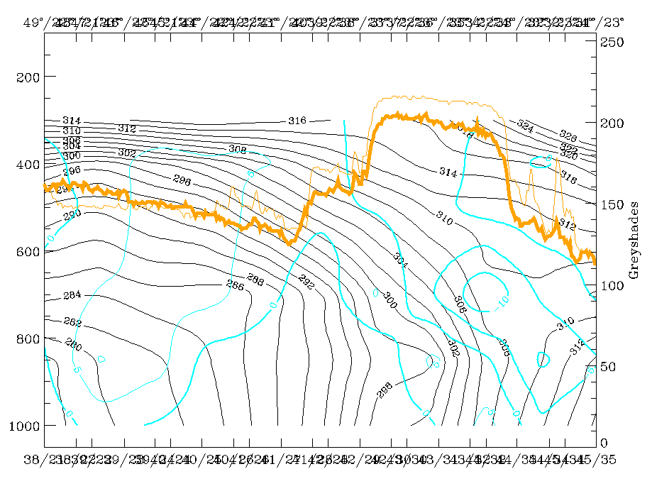
Relative streams give an additional, different insight into the frontal processes as they reveal the different air masses involved and the associated sinking and rising. Two isentropic surfaces are selected which are representative of the two frontal zones (right image): 294K, a surface on top of the northern Cold Front zone and 308K, a surface within the southern Warm Front zone.
|
15 March 1998/06.00 UTC - Meteosat IR image; magenta: relative streams 294K - system velocity 273° 7 m/s, yellow: isobars, SatRep
overlay: names of conceptual models
|
|
|
The low isentropic surface of 294K is inclined downward from about 400 hPa to the surface in the area of the Cold Front. There is a relative stream from northern directions, very similar to a dry intrusion which crosses a large part of the Cold Front band under sinking motion; only in the area of the Black Sea and north of it is there rising again, which is in conformity with the conceptual model of Front Intensification by Jet Crossing (compare Conceptual Models: Front Intensification by Jewt Crossing ). That part of the cloud band which consists mainly of low cloud tops is in accordance with the sinking part of the dry intrusion.
|
15 March 1998/06.00 UTC - Meteosat IR image; weather events (green: rain and showers, blue: drizzle, cyan: snow, red: thunderstorm with
precipitation, purple: freezing rain, orange: hail, black: no actual precipitation or thunderstorm with precipitation), magenta:
relative streams 308K - system velocity 273° 7 m/s, yellow: isobars, SatRep overlay: names of conceptual models
|
|
|
A completely different situation is found on the higher isentropic surface. It is inclined from 400 hPa down to about 750 hPa. The main characteristic is a heavily rising relative stream from the south-east which is very similar to a Warm Conveyor Belt and splits into an eastern and western branch. This splitting is caused by the site of the low. There are already precipitation reports in the area of most intensive rising over the Aegean Sea. North of the warm front band the sinking dry stream can be recognized, which turns and runs parallel to the rising Warm Conveyor Belt in the area of the Deformation Band forming a limiting streamline there.
So there is a very distinct synoptic situation with a sinking dry stream from the north on lower isentropes and a strongly rising Warm Conveyor Belt on isentropic surfaces above.
Very Short Range Forecast 06.00 - 18.00 UTC
|
15 March 1998/06.00 UTC - Meteosat IR image; yellow: thermal front parameter 500/850 hPa 06.00 UTC, green: thermal front parameter
500/850 hPa 12.00 UTC, blue: thermal front parameter 500/850 hPa 18.00 UTC, SatRep overlay: names of conceptual models
|
15 March 1998/06.00 UTC - Meteosat IR image; yellow: temperature advection - CA 06.00 UTC, green: temperature advection - CA 12.00 UTC,
blue: temperature advection - CA 18.00 UTC, SatRep overlay: names of conceptual models
|
|
|
|
|
|
15 March 1998/06.00 UTC - Meteosat IR image; yellow: temperature advection - WA 06.00 UTC, green: temperature advection - WA 12.00 UTC,
blue: temperature advection - WA 18.00 UTC, SatRep overlay: names of conceptual models
|
|
The most important parameters for a VSRF in this case are the TFP (left image top), cold advection (right image top) and warm advection (left image bottom). The TFP shows a southward propagation of the westward part of the Cold Front in Cold Advection from Bulgaria to the north Peloponnesus as well as a north-north-eastward propagation of the southern TFP branch. There is a mergence of both systems over the Aegean Sea and Turkey.
Two CA maxima are influencing Greece and the eastern Mediterranean Sea: one is approaching from the north on the rear side of the Cold Front in Cold Advection and propagating southward, and another one is approaching from the south on the rear side of the surface low propagating north-eastward (right image top). Till 18.00 UTC the zeroline of TA has moved eastward into the Aegean Sea and crosses Crete just in the middle. Thus, at 18.00 UTC VSRF says that colder air has overflown Greece and part of the Island while much warmer air is just overflowing Turkey.
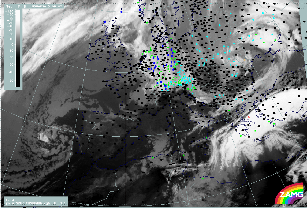
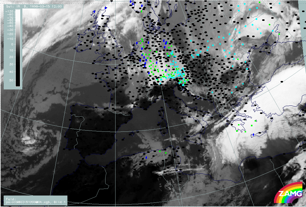
09.00 - 12.00 UTC - Overview of satellite imagery
|
15 March 1998/09.00 UTC - Meteosat IR image; weather events (green: rain and showers, blue: drizzle, cyan: snow, red: thunderstorm with
precipitation, purple: freezing rain, orange: hail, black: no actual precipitation or thunderstorm with precipitation)
|
15 March 1998/12.00 UTC - Meteosat IR image; weather events (green: rain and showers, blue: drizzle, cyan: snow, red: thunderstorm with
precipitation, purple: freezing rain, orange: hail, black: no actual precipitation or thunderstorm with precipitation)
|
|
|
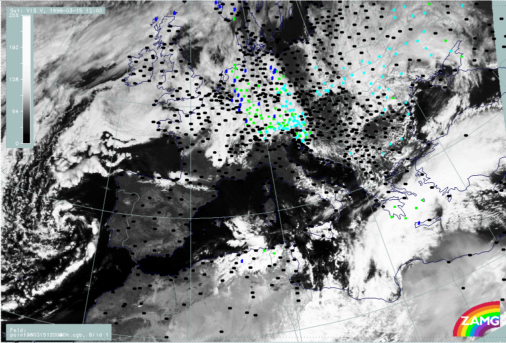
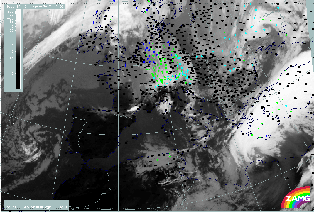
In the IR images the same two frontal cloud bands can be identified as before. They are already much closer to each other at 09.00 UTC (left image) and finally have merged at 12.00 UTC (right image). The Warm Front cloud band is still very bright and accompanied by thunderstorms and rain in the Aegean Sea and on the Peloponnesus. The cloud band of the Cold Front in Cold Advection consists only of lower cloud tops and its weather intensity is decreasing. At 12.00 UTC it extends from the Black Sea across north Greece westward.
|
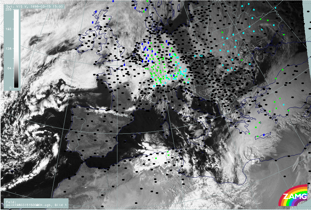
15 March 1998/09.00 UTC - Meteosat VIS image; weather events (green: rain and showers, blue: drizzle, cyan: snow, red: thunderstorm
with precipitation, purple: freezing rain, orange: hail, black: no actual precipitation or thunderstorm with precipitation)
|
15 March 1998/12.00 UTC - Meteosat VIS image; weather events (green: rain and showers, blue: drizzle, cyan: snow, red: thunderstorm
with precipitation, purple: freezing rain, orange: hail, black: no actual precipitation or thunderstorm with precipitation)
|
|
|
VIS images confirm that the warm front is accompanied by a thick cloud band with a rather smooth texture, while the northern Cold Front cloud band consists only of single cloud patches around 42N/31E, 41N/25E and 40N/21E and very small scale cold air cells with snow at their rear over Bulgaria.
|
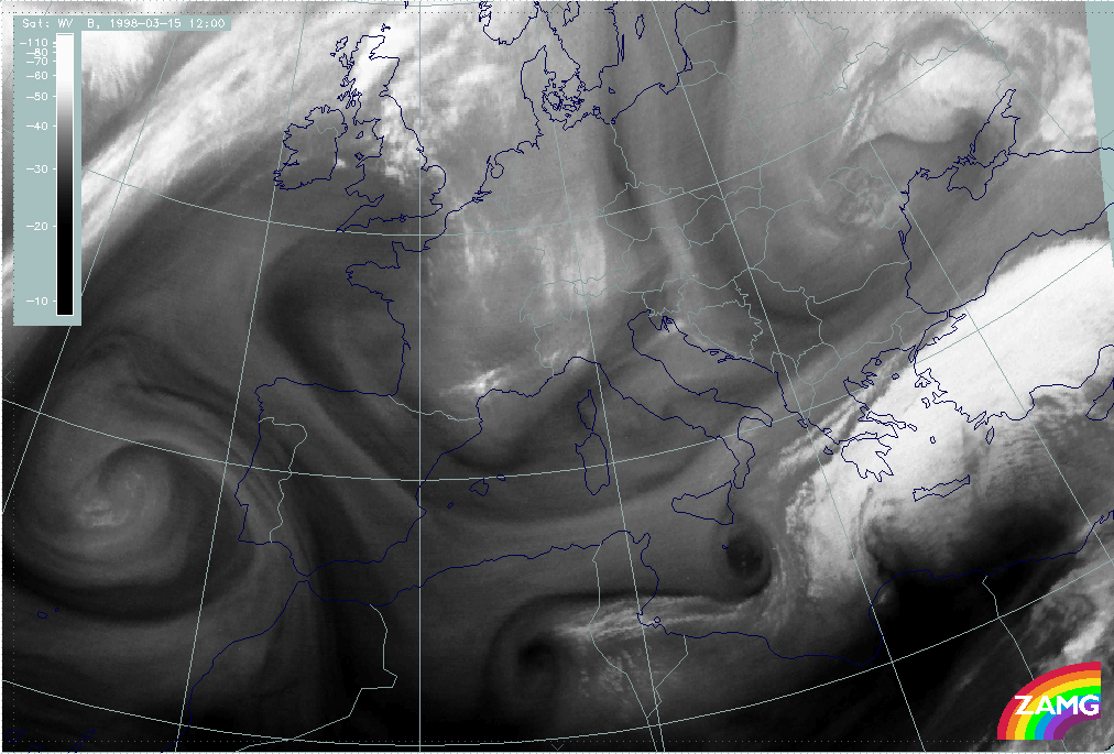
15 March 1998/09.00 UTC - Meteosat WV image
|
15 March 1998/12.00 UTC - Meteosat WV image
|
|
|
The WV images showing a grey warm front band add the information that there is a rather humid troposphere above the Cold Front in Cold Advection. But the most striking feature in the WV imagery is the black WV eye (compare Conceptual Models: Water Vapour Vortices ) in the Mediterranean south of Sicily, representing very dry sinking air. It is, however, not discussed in detail in this case study.
09.00 - 12.00 UTC - Key parameters on isobaric surfaces
|
15 March 1998/12.00 UTC - Meteosat IR image; red: height contours 1000 hPa, green: height contours 500 hPa
|
15 March 1998/12.00 UTC - Meteosat IR image; blue: thermal front parameter (TFP) 500/850 hPa, green: equivalent thickness 500/850 hPa,
red: temperature advection 1000 hPa
|
|
|
The images present surface (1000 hPa) and upper level height (left image), as well as parameters characterizing the frontal situation such as thickness, TFP and TA (right image).
Apart from advection there are no dramatic changes in the height fields (left image) compared to the situation six hours before: surface low and upper level trough in the Mediterranean have moved eastward. Consequently a huge upper level trough extending from Romania across Greece to north Africa has developed.
The two frontal zones characterised by the TFP (right image) are very close together; the northern one is situated over north Greece, the southern one crosses Crete and has approached the Turkish south coast. During these movements the CA fields influence Greece, partly from the north connected with the Cold Front in Cold Advection, partly from the west behind the low system in the Mediterranean.
|
15 March 1998/12.00 UTC - Meteosat IR image; green: wind vectors 850 hPa
|
15 March 1998/12.00 UTC - Meteosat IR image; magenta: wind vectors 500 hPa
|
|
|
The wind fields for 12.00 UTC even enhance the situation described for 06.00 UTC: there is at low levels a distinct confluence zone in the Aegean Sea and over the Peloponnesus with easterly wind directions but a south-west stream at high levels. In these high levels a confluence zone can be determined, too, but it is close to north Turkey.
09.00 - 12.00 UTC - Frontal Diagnosis - Use of vertical cross sections
|
15 March 1998/12.00 UTC - Meteosat IR image; position of vertical cross section indicated
|
15 March 1998/12.00 UTC - Vertical cross section; black: isentropes (ThetaE), orange thin: IR pixel values, orange thick: WV pixel
values
|

|

|
The left image shows the orientation of the vertical cross section line relative to the cloud bands, the right image the relation of isentropic zones and image pixel values in the vertical cross section. The main broad peak of the pixel values between 38N/23E and 36N/23E corresponds to the frontal cloud band in the Mediterranean, while the northern frontal cloud band can be seen only in the single peak around 40N/22E. Isentropes show still two frontal surfaces with surface fronts at 34N/23E and at approximately 39N/23E; both systems show a superadiabatic behaviour of isolines.
|
15 March 1998/12.00 UTC - Vertical cross section; black: isentropes (ThetaE), red thin: temperature advection - CA, red thick:
temperature advection - WA, orange thin: IR pixel values, orange thick: WV pixel values
|
|
|
The superimposed TA reflects the approach of cold air as the WA maximum has moved southward in relation to the southern frontal zone; although there is still WA in front of the southern frontal surface, CA is overrunning the frontal surface already in the middle troposphere (above 600 hPa); the northern system is still completely under the influence of CA.
|
15 March 1998/12.00 UTC - Vertical cross section; black: isentropes (ThetaE), magenta thin: divergence, magenta thick: convergence,
orange thin: IR pixel values, orange thick: WV pixel values
|
15 March 1998/12.00 UTC - Vertical cross section; black: isentropes (ThetaE), cyan thick: vertical motion (omega) - upward motion, cyan
thin: vertical motion (omega) - downward motion, orange thin: IR pixel values, orange thick: WV pixel values
|
|
|
The intensity of the frontal circulation cell is presented in the figures above with help of divergence (left image) and vertical motion (right image). The southern frontal zone is still very active with convergence up to 600 - 500 hPa and intensive upward motion. But a new interesting phenomenon has happened with the northern Cold Front in Cold Advection: the development of convergence in low layers (up to 800 hPa) accompanied by upward motion from the surface to 600 hPa (around 40N/22E). This fact might be a sign that although the frontal zone is not accompanied by extended cloudiness and although it seems to be inactive, there is still some inherent possibility of development.
09.00 - 12.00 UTC - Frontal Diagnosis - Relative streams and conveyor belts
|
15 March 1998/12.00 UTC - Meteosat IR image; position of vertical cross section indicated
|
15 March 1998/12.00 UTC - Vertical cross section; black: isentropes (ThetaE), orange thin: IR pixel values, orange thick: WV pixel
values
|
|
|
Looking again at the right figure, the following isentropic surfaces can be selected which represent the two frontal zones best: 304K is a surface connecting both frontal systems: in low layers it is within the southern frontal zone and in upper layers it is on top of the northern frontal system.
|
15 March 1998/12.00 UTC - Meteosat IR image; weather events (green: rain and showers, blue: drizzle, cyan: snow, red: thunderstorm with
precipitation, purple: freezing rain, orange: hail, black: no actual precipitation or thunderstorm with precipitation), magenta:
relative streams 304K - system velocity 284° 7 m/s, yellow: isobars
|
|
|
Relative streams on 304K show a very classical and very pronounced behaviour. There is a strongly rising and splitting relative stream similar to a Warm Conveyor Belt within the white cloud band of the southern front. It is connected with extended precipitation over the Peloponnesus and the adjacent sea areas. A limiting stream line appears close to the northern edge of the white cloud band separating the Warm Conveyor Belt from a relative stream from the north which is representing a dry intrusion. This relative stream is sinking from 400 hPa down to about 600 - 650 hPa and turning to north-eastern directions over north Greece where it begins to rise again.
So these are rather classical conditions of the conveyor belt theory representing a well-developed and intensive frontal system.
15.00 - 18.00 UTC - Overview of satellite imagery
|
15 March 1998/15.00 UTC - Meteosat IR image; weather events (green: rain and showers, blue: drizzle, cyan: snow, red: thunderstorm with
precipitation, purple: freezing rain, orange: hail, black: no actual precipitation or thunderstorm with precipitation)
|
15 March 1998/15.00 UTC - Meteosat VIS image; weather events (green: rain and showers, blue: drizzle, cyan: snow, red: thunderstorm
with precipitation, purple: freezing rain, orange: hail, black: no actual precipitation or thunderstorm with precipitation)
|
|
|
|
|
|
15 March 1998/18.00 UTC - Meteosat IR image; weather events (green: rain and showers, blue: drizzle, cyan: snow, red: thunderstorm with
precipitation, purple: freezing rain, orange: hail, black: no actual precipitation or thunderstorm with precipitation)
|
|
The images show the IR (left images top and bottom) and VIS (right image top) images and weather events from 15.00 and 18.00 UTC. In general, there are the same cloud features as before but the northern low top cloud band vanishes more and more under the bright cloud shield of the southern frontal band. The latter is connected with widespread rain over the Aegean Sea, Crete and south-east Turkey propagating eastward together with the cloud band. A new feature which can be observed during this period is a change in the low cloudiness at the rear side of the bright cloud band over Greece and the northern Aegean Sea; this low cloud patch clearly becomes more dense between 15.00 and 18.00 UTC. As this cloudiness is in connection with the southward moving Cold Front cloud band two explanations might be drawn:
- It is possible that the low frontal cloudiness intensifies, an idea which is supported by the development of a low level circulation cell, as was already seen and described in the vertical cross sections for 12.00 UTC;
- It is also possible that the bright dense Warm Front cloud band moves across the rather stationary low cloudiness of the northern band, which consequently becomes more and more visible.
|
15 March 1998/15.00 UTC - Meteosat WV image
|
15 March 1998/18.00 UTC - Meteosat WV image
|
|
|
The most important additional information from the WV images is that the humid band accompanying the northern frontal zone in the upper levels is now entirely over north Greece with a dry, Black Stripe at its northern boundary. The only conclusion which can be drawn from this observation is that there is enough humidity supply in middle and high levels above the low level cloudiness.
15.00 - 18.00 UTC - Key parameters on isobaric surfaces
|
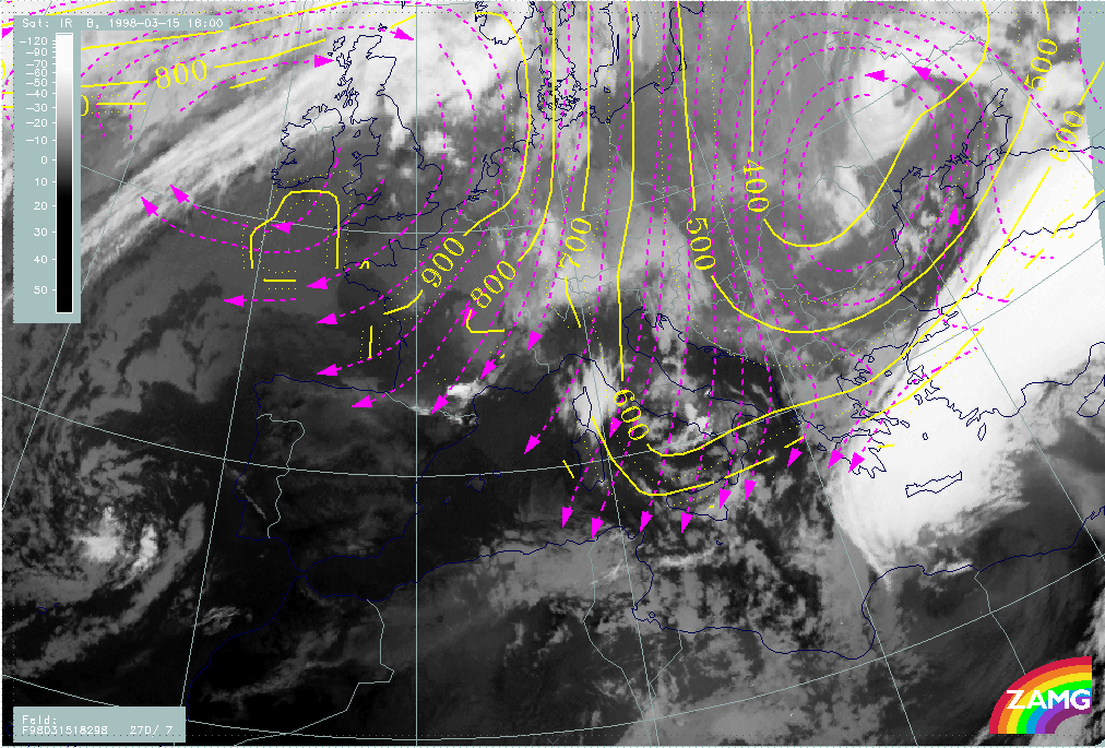
15 March 1998/18.00 UTC - Meteosat IR image; red: height contours 1000 hPa, green: height contours 500 hPa
|
15 March 1998/18.00 UTC - Meteosat IR image; blue: thermal front parameter (TFP) 500/850 hPa, green: equivalent thickness 500/850 hPa,
red: temperature advection 1000 hPa
|
|
|
The images above contain the same basic parameters for 18.00 UTC as before. Both surface low and upper level trough have moved eastward, which means that the upper level trough line has now reached the eastern coast of Greece. The WA area influences now only the eastern part of the Aegean Sea and Turkey while CA dominates over the Balkan Peninsula spreading southward across Greece to Africa.
|
15 March 1998/18.00 UTC - Meteosat IR image; green: wind vectors 850 hPa
|
15 March 1998/18.00 UTC - Meteosat IR image; magenta: wind vectors 500 hPa
|
|
|
This eastward movement is of course also reflected in the wind vector fields at 850 hPa (left image) and at 500 hPa (right image). The distinct confluence zone at the low level with eastern wind directions extends now from south-east Turkey to Crete while the still strong northern flow across Greece has developed a south-eastward component compared to six hours before. Upper level winds still have western components.
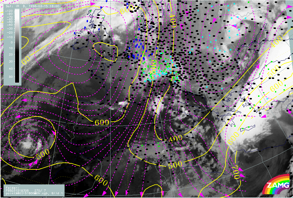
15.00 - 18.00 UTC - Frontal Diagnosis - Use of vertical cross sections
|
15 March 1998/18.00 UTC - Meteosat IR image; position of vertical cross section indicated
|
|

|
The image above shows the relation of the vertical cross section line to the cloud bands. Both the low cloudiness over Greece and the Aegean Sea as well as the bright white cloud band in the Mediterranean are cut perpendicularly.
|
15 March 1998/18.00 UTC - Vertical cross section; black: isentropes (ThetaE), orange thin: IR pixel values, orange thick: WV pixel
values
|
|
|
How the relevant features look in the vertical can be seen in the image above. The broad main peak in IR and WV between 36N/23E and 34N/23E represents of course the bright cloud band in the Mediterranean; the lower peak immediately northward between 40N/22E and 38N/23E represents the low cloudiness connected with the northern frontal zone. The isentropes show still two separated downward inclined frontal surfaces with surface fronts close to 33N/23E as well as 38N/23E. Both frontal surfaces show a superadiabatic inclination in the lowest layer up to about 800 hPa; isentropes between the two frontal surfaces show intensive instability there.
|
15 March 1998/18.00 UTC - Vertical cross section; black: isentropes (ThetaE), red thin: temperature advection - CA, red thick:
temperature advection - WA, orange thin: IR pixel values, orange thick: WV pixel values
|
|
|
In the cross section above temperature advection is superimposed; there is CA within the whole vertical cross section.
|
15 March 1998/06.00 UTC - Vertical cross section; black: isentropes (ThetaE), red thin: temperature advection - CA, red thick:
temperature advection - WA, orange thin: IR pixel values, orange thick: WV pixel values
|
15 March 1998/12.00 UTC - Vertical cross section; black: isentropes (ThetaE), red thin: temperature advection - CA, red thick:
temperature advection - WA, orange thin: IR pixel values, orange thick: WV pixel values
|

|

|
|
|
|
15 March 1998/18.00 UTC - Vertical cross section; black: isentropes (ThetaE), red thin: temperature advection - CA, red thick:
temperature advection - WA, orange thin: IR pixel values, orange thick: WV pixel values
|
|
As the geographical position of the vertical cross section has stayed the same during the last 12 hours, the advection of cold air from the north and from the west can clearly be followed from the sequence of cross sections for 06.00 UTC (left image top), for 12.00 UTC (right image top) and for 18.00 UTC (left image bottom).
|
15 March 1998/18.00 UTC - Vertical cross section; black: isentropes (ThetaE), magenta thin: divergence, magenta thick: convergence,
orange thin: IR pixel values, orange thick: WV pixel values
|
15 March 1998/18.00 UTC - Vertical cross section; black: isentropes (ThetaE), cyan thick: vertical motion (omega) - upward motion, cyan
thin: vertical motion (omega) - downward motion, orange thin: IR pixel values, orange thick: WV pixel values
|
|
|
Also in the divergence field (left image) a continuous development can be observed during the last 12 hours. The southern frontal zone is still accompanied by a typical zone of convergence. In the low layers of the northern frontal zone some convergence has developed already six hours before and still exists there, but at 18.00 UTC a newly developed small upper level convergence area can be localized at 41N/22E at 700 hPa. This supports the idea that there is some potential for development connected with the low cloud system. The relation between convergence and vertical motion (right image) is very classical, revealing a typical frontal circulation at the southern frontal zone but also some upward motion up to 750 hPa.
15.00 - 18.00 UTC - Frontal Diagnosis - Relative streams and conveyor belts
|
15 March 1998/18.00 UTC - Meteosat IR image; position of vertical cross section indicated
|
15 March 1998/18.00 UTC - Vertical cross section; black: isentropes (ThetaE), orange thin: IR pixel values, orange thick: WV pixel
values
|
|

|
From the right image it can be seen that the isentropic surface of 298K is above the lower frontal zone and therefore characteristic of the low cloud area of the northern front, and that 308K is above the southern frontal zone.
|
15 March 1998/18.00 UTC - Meteosat IR image; magenta: relative streams 298K - system velocity 270° 7 m/s, yellow: isobars
|
15 March 1998/18.00 UTC - Meteosat IR image; weather events (green: rain and showers, blue: drizzle, cyan: snow, red: thunderstorm with
precipitation, purple: freezing rain, orange: hail, black: no actual precipitation or thunderstorm with precipitation), magenta:
relative streams 308K - system velocity 284° 7 m/s, yellow: isobars
|
|
|
The situation on both isentropic surfaces at 18 UTC is nearly unchanged from 12.00 UTC (compare 09.00 - 12.00 UTC - Frontal Diagnosis - Relative streams and conveyor belts). There is a sinking dry intrusion from 500 down to 700 hPa over the low cloudiness of the northern frontal zone but intensive rising of a Warm Conveyor Belt over the Aegean Sea and Turkey which is also connected with an extended zone of precipitation. A limiting streamline between the rising warm wet stream from the south (Warm Conveyor Belt) and the sinking cold dry stream from the north (dry intrusion) can be found at the distinct northern and western cloud edges of the bright cloud band.
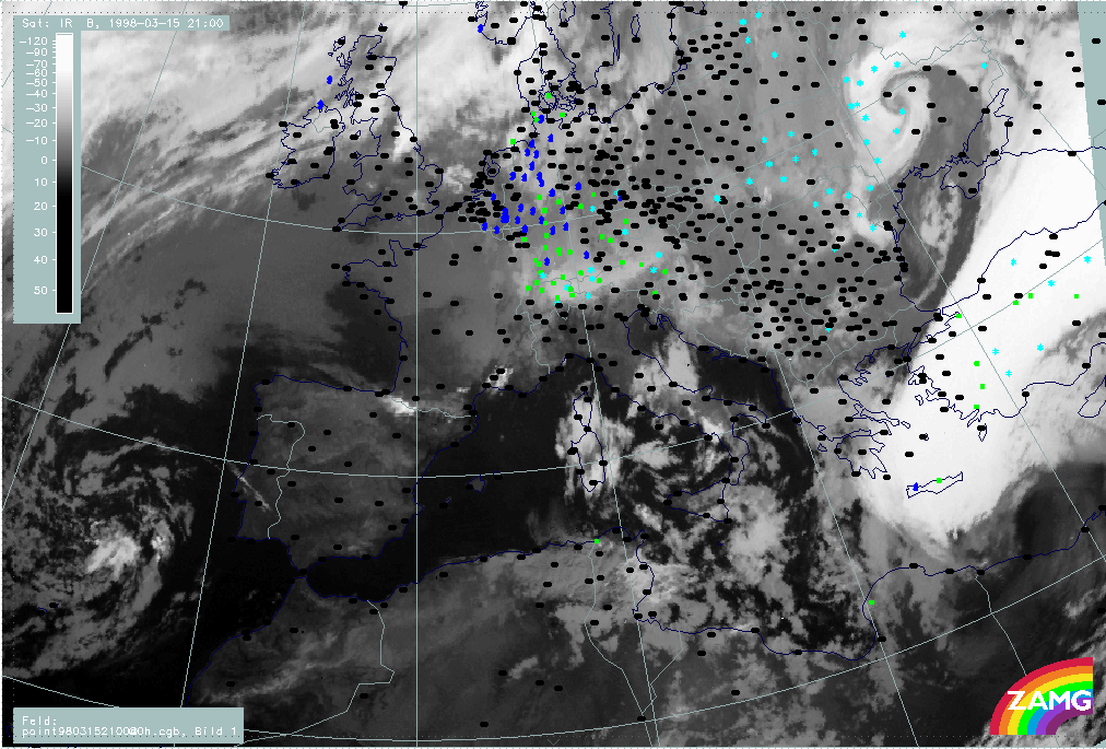
15/21.00 - 16/00.00 UTC - Overview of satellite imagery
|
15 March 1998/21.00 UTC - Meteosat IR image; weather events (green: rain and showers, blue: drizzle, cyan: snow, red: thunderstorm with
precipitation, purple: freezing rain, orange: hail, black: no actual precipitation or thunderstorm with precipitation)
|
16 March 1998/00.00 UTC - Meteosat IR image; weather events (green: rain and showers, blue: drizzle, cyan: snow, red: thunderstorm with
precipitation, purple: freezing rain, orange: hail, black: no actual precipitation or thunderstorm with precipitation)
|
|
|
Although the main cloud features can still be observed, the IR images reveal some changes now. The most important change with the southern frontal zone is its considerable movement; the white cloud band extends now from Crete across Turkey to the Black Sea and is accompanied by intensive precipitation in the central and southern parts of the cloudiness. The most important change with the northern system of the lower clouds is that is has become a dominating feature in an area extending from Greece southward to Africa; also some intensification of the grey shades has taken place compared to six hours before. But there is no band - like, frontal organization of the low cloud fields any longer.
|
15 March 1998/21.00 UTC - Meteosat WV image
|
16 March 1998/00.00 UTC - Meteosat WV image
|
|
|
The WV images add some information about the WV content higher up. The area of the low clouds described in the IR images does not show up as the same or similar configuration in the WV features. Rather, the latter still indicate the former northern Cold Front zone with a long WV band stretching from the Mediterranean west of Greece across Greece to the Black Sea.
15/21.00 - 16/00.00 UTC - Key parameters on isobaric surfaces
|
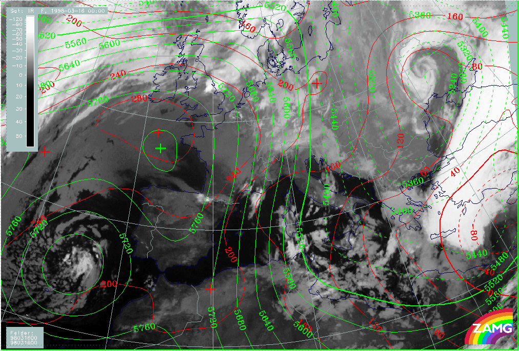
16 March 1998/00.00 UTC - Meteosat IR image; red: height contours 1000 hPa, green: height contours 500 hPa
|
|
|
The height fields show that the Mediterranean surface low and the upper level trough have moved to the easternmost parts of the Mediterranean and to Turkey. The two upper level trough systems are now uncoupled again (as was the case at the start of this case study (compare 06.00 UTC - Key parameters on isobaric surfaces). The reason for this is that the southern trough has moved more quickly than the northern one, which is still located over Greece exactly in the area of the low level cloud system. In the same area a secondary small-scale trough has developed close to the surface (extending from Crete across the west Peloponnesus to south Italy). Such a distribution is a typical feature for cold air cloudiness and therefore has to be kept in mind and observed further.
|
16 March 1998/00.00 UTC - Meteosat IR image; blue: thermal front parameter (TFP) 500/850 hPa, green: equivalent thickness 500/850 hPa,
red: temperature advection 1000 hPa
|
|
|
In the frontal parameters a rather complicated TFP structure can be noticed. From the west coast of Turkey in north-eastward directions there is only one TFP zone (which is also in front of a distinct thickness gradient), but two TFP zones have developed over and south-east of Greece respectively. The thickness fields with a lack of any distinct gradient indicate that these TFP branches do not represent classical frontal zones; the one over Greece is connected with the low cloud area in the surface and upper level trough, the south-eastern one forms the north-eastern boundary of the distinct surface low. The complete area from the Balkan Peninsula across Greece to the coast of Turkey is under the influence of CA, while over Turkey strong WA prevails.
|
15 March 1998/18.00 UTC - Meteosat IR image; green: wind vectors 850 hPa
|
15 March 1998/18.00 UTC - Meteosat IR image; magenta: wind vectors 500 hPa
|
|
|
The wind vector fields for 850 hPa (left image) and for 500 hPa (right image) do not show any overall changes apart from of course advection. At 850 hPa there is a strong and broad north to north-east flow from Russia to Greece and Turkey (except the south and south-east parts of Turkey) and at 500 hPa western directions dominate with north-west and south-west components, depending on the location at the leading respectively or side of the trough.
15/21.00 - 16/00.00 UTC - Frontal Diagnosis - Use of vertical cross sections
|
16 March 1998/00.00 UTC - Meteosat IR image; position of vertical cross section indicated
|
|
|
As can be seen in the image above, the vertical cross section has now a different orientation compared with the cross sections discussed for the 12 hours period before (compare 09.00 - 12.00 UTC - Frontal Diagnosis - Use of vertical cross sections and 15.00 - 18.00 UTC - Frontal Diagnosis - Use of vertical cross sections). It was chosen in such a way as to be perpendicular to both TFP zones and to have a similar relation to the cloud features as before.
|
16 March 1998/00.00 UTC - Vertical cross section; black: isentropes (ThetaE), orange thin: IR pixel values, orange thick: WV pixel
values
|
|

|
The relation between isentropes and satellite pixel values can be seen in the image above. The main broad IR and WV peak between 37N/23E and 34N/27E represents the white cloud band, the smaller IR peak between 39N/18E and 39N/21E represents the low top cloudiness over Greece. For this peak the WV signal is rather small, indicating areas with dry WV values above. For the first time during this case study only one main frontal zone can be detected in the isentropes, but it has to be considered that the orientation of the vertical cross section line differs from that previously. The surface front is in the leading part of the bright cloud band but remnants of the former northern frontal surface might be detectable in the isentropes reaching the surface around 39N/21E.
|
16 March 1998/00.00 UTC - Vertical cross section; black: isentropes (ThetaE), red thin: temperature advection - CA, red thick:
temperature advection - WA, orange thin: IR pixel values, orange thick: WV pixel values
|
|
|
As six hours before, the whole area of the vertical cross section is under intensive CA (compare 15.00 - 18.00 UTC - Frontal Diagnosis - Use of vertical cross sections).
|
16 March 1998/00.00 UTC - Vertical cross section; black: isentropes (ThetaE), magenta thin: divergence, magenta thick: convergence,
orange thin: IR pixel values, orange thick: WV pixel values
|
16 March 1998/00.00 UTC - Vertical cross section; black: isentropes (ThetaE), cyan thick: vertical motion (omega) - upward motion, cyan
thin: vertical motion (omega) - downward motion, orange thin: IR pixel values, orange thick: WV pixel values
|
|
|
The field of divergence (left image) supports the idea of having two different synoptic systems: the main one is a frontal one and shows convergence in middle and upper layers and, for the first time during this case study, divergence in the low layer; a second convergence maximum can be found between 900 and 650 hPa in the area of the low cloud area; the development of convergence in the lowest layer was already mentioned during the last 12 hours where this area was still a frontal zone. This new and intensified convergence area over Greece where the low level cloudiness exists is connected with pronounced vertical motion above (right image). This situation might support the development or maintenance of this cloud field. In contrast to this, the situation at the main front might be interpreted as beginning dissolution.
15/21.00 - 16/00.00 UTC - Frontal Diagnosis - Relative streams and conveyor belts
|
16 March 1998/00.00 UTC - Meteosat IR image; position of vertical cross section indicated
|
16 March 1998/00.00 UTC - Vertical cross section; black: isentropes (ThetaE), orange thin: IR pixel values, orange thick: WV pixel
values
|

|
|
All isentropic surfaces in the area of the low top cloudiness over Greece show sinking in high and middle layers; this will be demonstrated by one example: 300K which is an isentropic surface close to the bottom of the main frontal surface (right image).
|
16 March 1998/00.00 UTC - Meteosat IR image; magenta: relative streams 300K - system velocity 269° 8 m/s, yellow: isobars
|
|
|
In the image above relative streams very similar to the situations before can be observed (compare 15.00 - 18.00 UTC - Frontal Diagnosis - Relative streams and conveyor belts). There is a limiting streamline at the north-western boundary of the white cloud band between warm rising air from the east and sinking dry air from the north. The relative streams in this westernmost part of the white cloud band are turning and sinking, which might be the reason for decay of cloudiness leading to a sharp cloud boundary there. The sinking of dry air in the area of the low level cloudiness over Greece might be the reason for the restriction of the cloud tops there.
03.00 - 06.00 UTC - Overview of satellite imagery
|
16 March 1998/03.00 UTC - Meteosat IR image; weather events (green: rain and showers, blue: drizzle, cyan: snow, red: thunderstorm with
precipitation, purple: freezing rain, orange: hail, black: no actual precipitation or thunderstorm with precipitation)
|
16 March 1998/03.00 UTC - Meteosat IR image; SatRep overlay: names of conceptual models
|
|
|
As can be seen in the IR images above, the white cloud band of the front and the low cloud features over and south of Greece are completely uncoupled now. Some precipitation has developed within this low top cloudiness over Greece; the frontal cloud band is still connected with extended precipitation over Turkey.
|
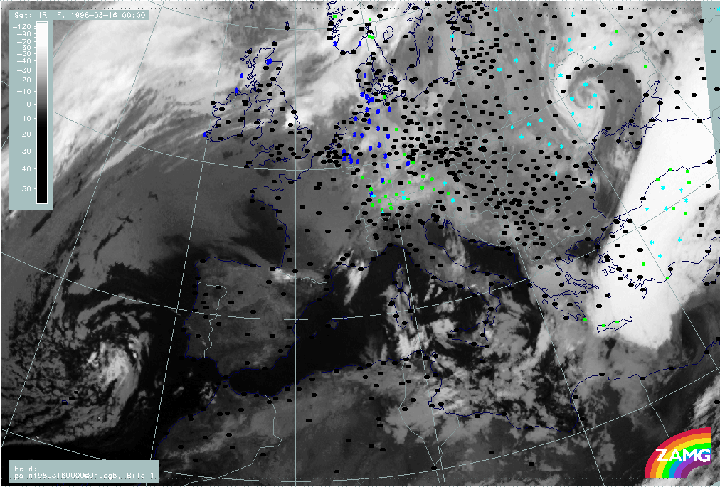
16 March 1998/06.00 UTC - Meteosat IR image; SatRep overlay: names of conceptual models
|
16 March 1998/06.00 UTC - Meteosat VIS image; weather events (green: rain and showers, blue: drizzle, cyan: snow, red: thunderstorm
with precipitation, purple: freezing rain, orange: hail, black: no actual precipitation or thunderstorm with precipitation), SatRep
overlay: names of conceptual models
|
|
|
|
|
|
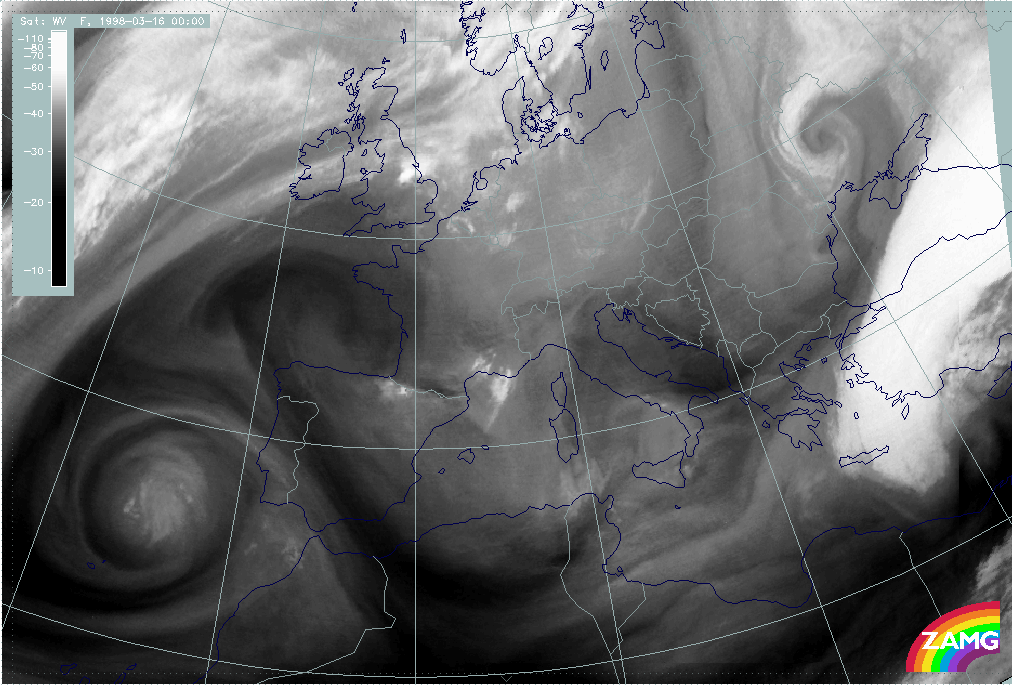
16 March 1998/06.00 UTC - Meteosat WV image
|
|
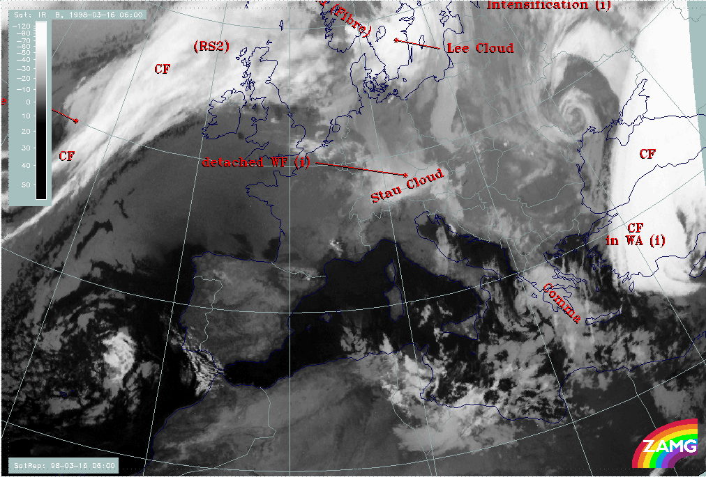
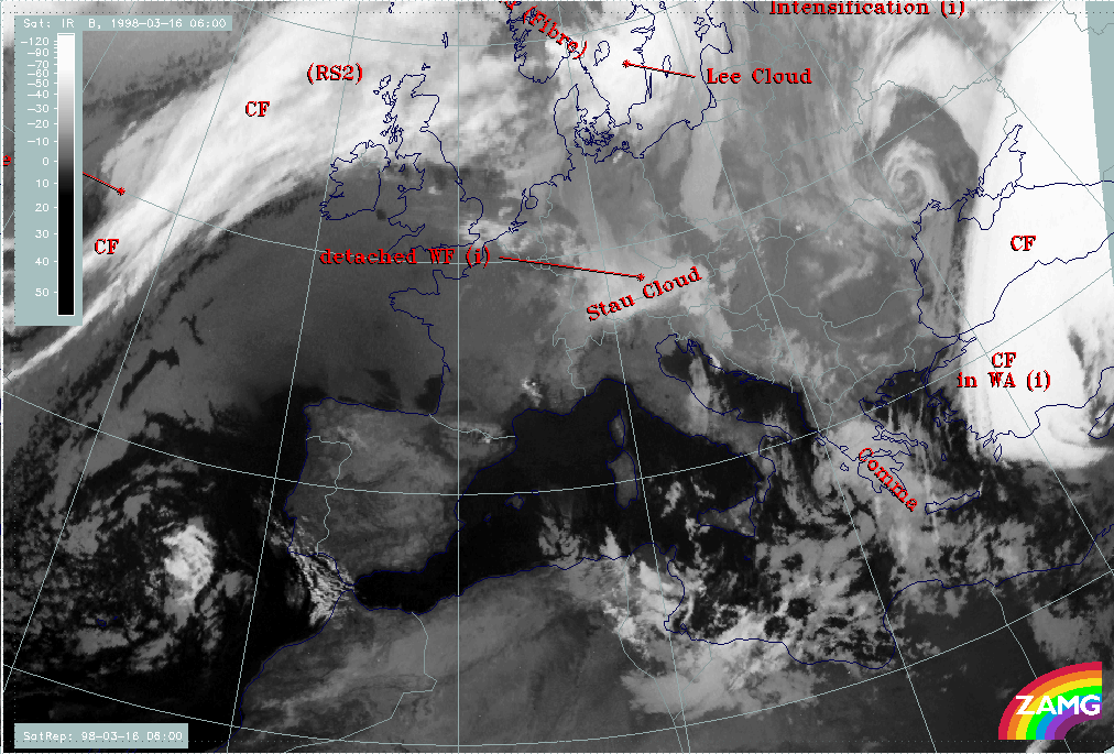
The most interesting cloud feature at 06.00 UTC is the low cloud feature which has been diagnosed in the actual SatRep as a Comma (compare Conceptual Models: Comma ). There is some discrepancy with the ideal description of this conceptual model since a Comma should usually consist of thick cellular cloudiness and not, as in this case, of rather warm and smooth cloud tops; however in the VIS image (right image top) the cyclonic curvature of the Comma system can be detected more easily and the texture shows some cellular features. Besides this there is rain and snow in the Comma area over the Peloponnesus. It is laready known from before that a sinking dry relative stream in upper and middle heights might be a reason for a restriction of cloud growth. A further confirmation of a Comma structure can be found in the WV image (left image bottom) which reveals the Comma structure quite well.
There seems to be (and was already before) some discrepancy in the interpretation of the WV features made so far. On the one hand the grey wet zones accompanying the Cold Front band and its remnants are mentioned and interpreted as a humidity supply from above, on the other hand a lack of vertical growth of cloud tops is explained by sinking dry air. The solution of this contradiction seems to lie in the word sinking. Although the grey WV features reflect the configuration of the frontal band and the Comma, the existing sinking motion in these layers leads to a drying of the troposphere; this additional information is gained from an application of the conveyor belt concept. Another source dealing with this matter is the vertical cross sections which reveal for six hours before, as well as at this time, (compare 03.00 - 06.00 UTC - Comma Diagnosis - Key parameters on isobaric surfaces) that the WV signal is rather low compared to the IR signal and to other synoptic systems.
03.00 - 06.00 UTC - Comma Diagnosis - Key parameters on isobaric surfaces
In addition to the diagnosis of the Comma cloud structure from satellite images just described, some of the key parameters on isobaric surfaces also support such a diagnosis.
|
16 March 1998/06.00 UTC - Meteosat IR image; red: height contours 1000 hPa, green: height contours 500 hPa, SatRep overlay: names of
conceptual models
|
16 March 1998/06.00 UTC - Meteosat IR image; blue: thermal front parameter (TFP) 500/850 hPa, green: equivalent thickness 500/850 hPa,
red: temperature advection - CA 1000 hPa, SatRep overlay: names of conceptual models
|
|
|
|
|
|
16 March 1998/06.00 UTC - Meteosat IR image; yellow: positive vorticity advection (PVA) 500 hPa, SatRep overlay: names of conceptual
models
|
|
The surface and upper level trough (left image top) is a quite typical configuration for a Comma. Such a feature has already been observed six hours before but the surface trough has intensified now (compare 15/21.00 - 16/00.00 UTC - Key parameters on isobaric surfaces). The cloud feature is under CA (right image top) and (although not in ideal agreement) there is a distinct PVA maximum (left image bottom) close to the Comma head, which is another key parameter supporting the diagnosis of this conceptual model.
03.00 - 06.00 UTC - Comma Diagnosis - Use of vertical cross sections
|
16 March 1998/06.00 UTC - Meteosat IR image; position of vertical cross section indicated
|
|
|
Some additional hints can also be derived from the use of vertical cross sections. The vertical cross section line is perpendicular to the Comma and to the rest of the frontal cloud band over Turkey.
|
16 March 1998/00.00 UTC - Vertical cross section; black: isentropes (ThetaE), orange thin: IR pixel values, orange thick: WV pixel
values
|
|
|
As can be seen in the image above, the broad peak of high values between 37N/26E and 37N/32E corresponds to the white frontal cloud band, while the secondary peak between approximately 36N/20E and 37N/22E represents the Comma. The WV signal is low in the Comma area indicating dry air above, although the driest air connected with the Black Stripe can be found at the rear of the Comma.
|
16 March 1998/06.00 UTC - Vertical cross section; black: isentropes (ThetaE), magenta thin: divergence, magenta thick: convergence,
orange thin: IR pixel values, orange thick: WV pixel values
|
16 March 1998/06.00 UTC - Vertical cross section; black: isentropes (ThetaE), green thick: vorticity advection - PVA, green thin:
vorticity advection - NVA, orange thin: IR pixel values, orange thick: WV pixel values
|
|
|
|
|
|
16 March 1998/06.00 UTC - Vertical cross section; black: isentropes (ThetaE), cyan thick: vertical motion (omega) - upward motion, cyan
thin: vertical motion (omega) - downward motion, orange thin: IR pixel values, orange thick: WV pixel values
|
|
Very striking is the increase of upward motion (left image bottom) compared to the time before (compare 15/21.00 - 16/00.00 UTC - Frontal Diagnosis - Use of vertical cross sections). Both convergence in low (left image top) and PVA in upper levels (right image top) work together and lead to a well developed maximum of upward motion. This is the reason that the Comma structure is maintained throughout the day, intensifying and becoming a more distinct spiral structure later on.
Summarizing, one can say that the development of the Comma is rather untypical. It happened in the cold air behind a Cold Front but below the cloud shield of an approaching frontal zone from the south. Only after this frontal system propagated eastward did the Comma cloudiness become visible. But even then a sinking dry relative stream restricted the growth of the Comma clouds. Nevertheless the physical environment for a Comma was fulfilled quite well and hence the cloud feature was rather long-lived and intensifying later on.