Interpretation
Geopotential Height 300 hPa.
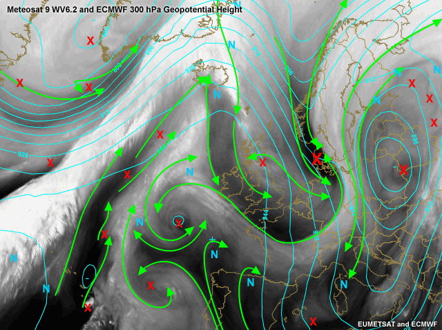
The interpretation by the "expert" shows several (small-scale) vorticity minima and maxima. You probably would not have recognised all of these. A helpful tool for you to start analysing a water vapour image is by identifying the deformation zones (DZ). Most often, the DZ is much more apparent and much more obvious than the circulation of the vorticity centre. The S-shaped DZ's dominate in a ridge. Backward S-shaped DZ's dominate in a trough. Convex DZ's tend to be larger, associated with significant thermal advections and straddle a ridge and trough pair.
The linear axis of maximum winds can be used in the same way as the DZ to infer the type, location and relative intensity of the associated vorticity centres. In straight flows, the vorticity centres are really strung within an elongated vorticity lobe. If the flow is curved, the type of curvature determines which vorticity lobe is enhanced and which is weakened.
Isotachs and PVA 300 hPa.
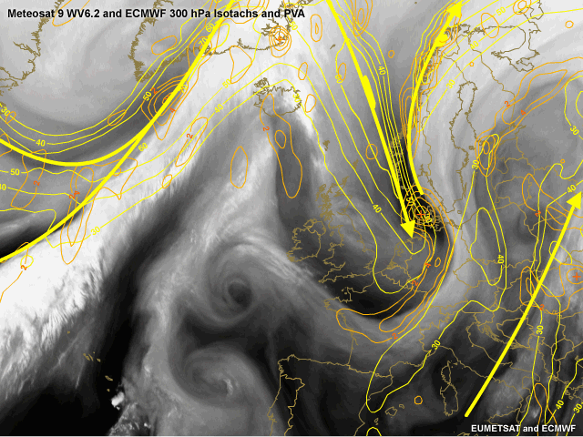
In this image the isotachs (Yellow) and positive vorticity advection (orange), both at 300 hPa. are plotted. The location and orientation of the jet in such a classical anticyclonic circulation is not hard to find. An important feature is the diagnosis of a PVA maximum over Denmark. This maximum is found in the left exit region of the jet. The upper level divergence introduces the birth of a new cyclone that is well seen in the WV image as the dark shade. Left exit region of the jet is classical for cyclogenesis and should be carefully considered when doing your forecast.
Isentropic Potential Vorticity 315K
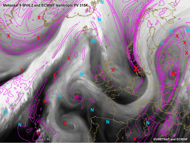
In magenta, the potential vorticity at the isentropic level of 315K is plotted. Maximum values should be found where the expert has placed an X. The model forecast (+18 hour) is in good accordance with reality with only the vorticity maximum over Scotland and the maximum between Portugal and Madeira being missed.
Relative Vorticity 500 hPa.
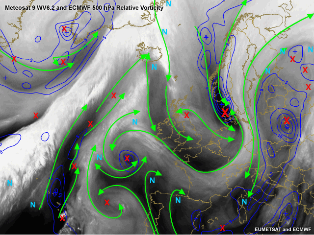
In blue the relative vorticity with 0.5° resolution of ECMWF is plotted. Large vorticity maxima are assoicated with the frontal system over the Atlantic with its depression west of Greenland. A further maximum is associated with the left exit region of the jet and is found in Denmark. A third large scale maximum is associated with a depression over Poland and Ukraine. This cyclone causes polar air to be transported from north to south bringing winterly conditions in Central Europe. Again two vorticity maxima are not picked up by the model. First a smaller maximum over Scotland. That the model did not pick this up could be due to the model resolution of 0.5°. A more pronounced maximum is found west of Portugal. The cyclonic structure is clear in the WV6.2 set of images but ECMWF does not diagnose it in the +18 hour model run. The impact that this latter maximum could have on your forecast is questionable but still you need to be aware of the potential this could have when dealing with different conceptual models such as Upper level lows, Cold air outbreaks or Rapid cyclogenesis!