Authors
| ZAMG | DHMZ | DWD |
| Jarno Schipper | Dunja Plaèko | Wilfried Jacobs |
Introduction
The 21, 22nd and 23rd June 2007 turned out to be three weather active days. Most of Central Europe was plagued by severe convection which included heavy thunderstorms. Hail and wind bursts killed several people and caused damage in millions of Euros. In this case study we will start with the presentation of the weather on the synoptic scale during the three days to give you some background information. We will then zoom in both spatial and temporal to give some additional information on each of the three dates. This will include a series of presentations from different products derived from various sources.
|
|
|
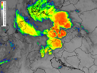
Meteosat 9 Enhanced IR10.8 21th June 2007: 1415UTC |
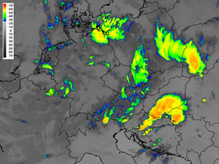
Meteosat 9 Enhanced IR10.8 23rd June 2007: 0045UTC |
The left picture shows the convectivity on 21st June when large areas of Germany, Austria and Czech Republic where affected by thunderstorms. The enhanced IR10.8 image we see here shows several cells different in size. A better look even reveals some donut shaped storms with overshooting tops. The image to the right shows the convective situation over Croatia that started late afternoon on the 22nd June. Triggered by the Dinaric Alps convection grew rapidly under unstable conditions.
Beside the presentation of MSG images this chapter also includes an extra chapter on the METOP satellite. Several products relevant for the21st June are presented and described.
The aim of this case study is to:
- Study plain MSG satellite images as well as artificial coloured RGB combinations
- Study satellite images and products derived from the polar orbiting satellite METOP
- Study on how to relate satellite imagery with NWP
To be able to follow the case study from the beginning it is preferable to study the chapters dealing with convection from the "Manual of Satellite Meteorology", and the PowerPoint's dealing with hazardous small scale weather from the "MSG Interpretation Guide" .