Authors
LCRSThomas Lotz
André Obregón
DWD
Wilfried Jacobs
Introduction
On 27 July 2006 such short-living-convective cells developed over Germany. These convective events marked the end of a long lasting heat period which characterized July 2006. Reports about thunderstorms and heavy local rainfalls were issued. Heavy rainfall flooded streets and cellars, lightning damaged houses and trees were uprooted by heavy gusts. A huge crane was blown over and crashed into the Neckar river.
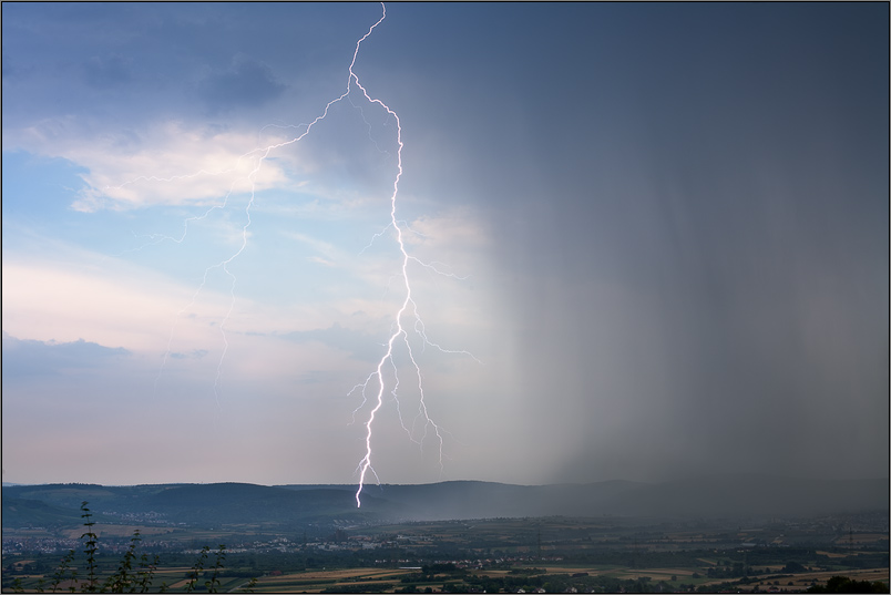
Beginning of thunderstorm near Stuttgart on 27 July 2006
(Photo by Moritz von Hacht: www.wetter-foto.de)
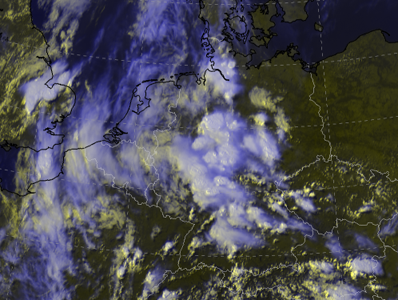
The RGB and IR images below show the severe convection over Germany. The colours in the IR 10.8 Enhanced give the cloud top temperatures. Blue and violet colours indicate very low temperatures (up to -64°C).
 |
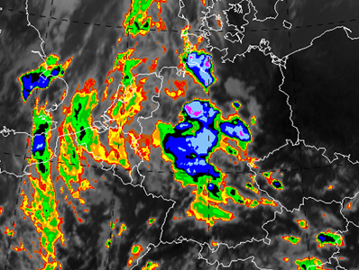 |
| Meteosat-8 RGB HRV/HRV/IR10.8: 27 July 2006: 15 UTC. | Meteosat-8 IR10.8 Enhanced: 27 July 2006: 15 UTC. |
This case study deals with different parameters describing the preconditions and development stages of convective processes. There are some typical phenomena in association with summer convection occurring during this day:
- Development of multi and super cells
- Cell splitting or "severe right moving"
- Development of a squall line
- Surface pressure with a dipole structure connected to severe convection
Parameters used in this case study:
- Satellite imagery:
- IR10.8 Enhanced
- WV6.2
- RGB Composites:
- Convective Storms RGB
- Airmass RGB
- High Resolution Visible RGB
- Basic Synoptic Parameters:
- Weather charts
- Surface pressure tendencies
- Geopotential height 300 hPa
- Pseudopotential temperature and wind
- Maximum wind speeds during the last hour
- Surface observations
- Lightning observations during the last half hour
- Radar:
- DWD PI (international composite)
- NWP Parameters:
- IPV 310 K
- Vertical Motion 500 hPa
- Thermal Front Parameter + Relative Topography
- Temperature Advection 700 hPa
- Soundings (field distribution):
- Nakamura Gusts
- Precipitable Water
- KO-Index
- Station Bergen (northern Germany):
- Detailed Investigations
- Nowcasting-SAF-product "Lifted index":
- Interpretation
- Limitations
- Potential instability
- Upward motion
- Diabatic heating through insolation (free convection).
- Warm air advection in lower levels and cold air advection in upper levels yielding increased vertical temperature gradient
- Orographic induced upward motion (forced convection)
- Upward motion due to synoptic forcings (e.g., leading edge of a trough, convergence near surface).
- Squall line (cloud patterns, surface pressure tendencies, position of radar reflectivity and lightning detections in relation to cloud tops)
- Convective cloud features at the leading edge of frontal cloud bands (see Manual of Synoptic Satellite Meteorology)
- Enhancement of convection by PV (in relation to dark stripes) (see Manual of Synoptic Satellite Meteorology)
Preconditions likely for thunderstorms:
Initiating mechanisms for convection:
The preconditions for convection are discussed and investigated by several basic meteorological parameters and derived model parameters in relation to Meteosat-8 images. Radar data and lightning detection are used additionally due to their importance for summer convection diagnostics.
Following conceptual models are considered:
LCRS - Laboratory for Climatology and Remote Sensing
Faculty of Geography, University of Marburg
Germany