Authors
ZAMGJarno Schipper
Veronika Zwatz-Meise
Introduction
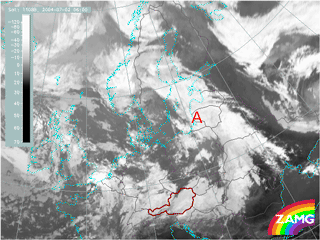
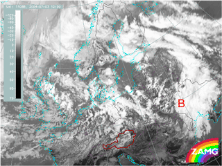
This case study will be about the development of two waves within a frontal system over Central and East Europe. In the pictures below they are indicated by A and B.

|

|
| Meteosat 8 IR: 2nd July 2004: 06 UTC | Meteosat 8 IR: 3rd July 2004: 12 UTC |
The aim of this case study is to:
- Follow the different development stages in satellite imagery with the help of basic and combined satellite channels
- Investigate the physical background by using relevant numerical parameters and relate the actual case to conceptual models of typical wave developments
- Find out the differences between the two cases in order to get help in the decision making processes of forecasters
To be able to follow the case study from the beginning it is preferable to study the chapters "Wave", "Upper Wave" and "Front Intensification by Jet Crossing" from the “Manual of Synoptic Satellite Meteorology”.
A wave is a substructure of a cold front which indicates the initial stage of (secondary) cyclogenesis. It has a typical appearance in satellite images showing a bulge of cloudiness at the rear edge of a frontal cloud band. If the forecaster combines the typical appearance in satellite images with the configuration of three basic parameters, namely: temperature advection (in this study at 700 hPa), surface pressure (in this study geopotential height at 1000 hPa) and Positive Vorticity Advection (PVA) at 500 hPa a wave can be recognised already in an early stage. In addition to these basic parameters also upper air parameters like jetstreaks and PVA at jet level as well as Potential Vorticity (PV) are important deciding criteria in the development process of a wave.
In this case study it will be seen that the two wave developments have similarities and differences. In satellite images the two waves show a similar appearance but they differ much in the rate of development. With the use of basic and derived numerical parameters these differences will be worked out.