Authors
ZAMGJarno Schipper
Veronika Zwatz-Meise
Introduction
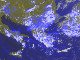
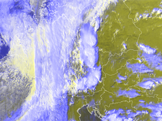
This case study will be about the severe convective development in Central and Southeastern Europe. In the pictures below both of these convective areas are pictured.
|
|
|
Meteosat 8 RGB (HRVIS; HRVIS; IR10.8) 29th May 2005: 1200UTC |
Meteosat 8 RGB (HRVIS; HRVIS; IR10.8) 30th May 2005: 1500UTC |
The left picture shows the convective area which is addressed in the first part of this case study. Numerous cells are covering the coastal regions of Greece, Turkey, Albania, Italy and Bulgaria. Reports of thunderstorms, rain in association with hail were observed on this day. In the right picture three seperated mesoscalic cloud systems (MCS) are seen covering Austria, Czech Republic and the Southwestern part of Poland. The shadow of these cells on the earth surface can clearly be recognised. At a later stage these seperate cells merge and supercell storms are observed. Numerous reports of hail were reported associated to this event.
The aim of this case study is to:
- Follow the different convective development stages in satellite imagery with the help of basic and combined satellite channels
- Investigate the physical background by using relevant numerical parameters and relate the actual case to conceptual models of convection at the leading edge of a front and convection in fair weather.
- Using Nowcasting and other derived MSG products to nowcast convective development
- Find out the differences between the two convective situations in order to get help in the decision making processes of forecasters
To be able to follow the case study from the beginning it is preferable to study the chapters dealing with convection from the "Manual of Satellite Meteorology", and the powerpoints dealing with hazardous small scale weather from the "MSG Interpretation Guide" .
In the case study two types of convective development are observed and addressed. At the 30th of May a broad N-S oriented frontal zone is covering Western Europe. On the leading side of this front several convective cells emerge. It is at this position that in WV imagery a dry intrusion is observed. Also in Greece and Turkey several cells emerge on the boundary of low and high pixelvalues of the WV imagery. The convective development in Greece and Turkey can be characterised as fair weather convection. This boundary represents the transition between relatively humid and dry air at levels above 600 hPa.
In this case study it will be seen that the convective developments have similarities and differences. With use of several Meteosat 8 satellite images and composites and with the use of basic and derived numerical parameters these differences and similarities will be worked out.