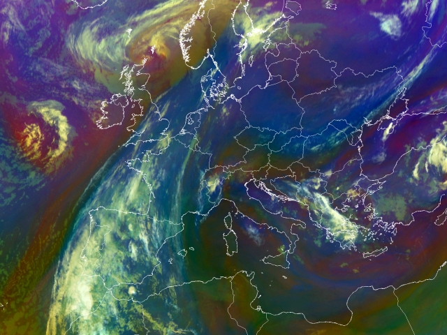
29th May 2005: 00UTC
In this first airmass image the frontal system over Western Europe is easily picked up. The overrunning jet in the Occlusion part of the front causes these clouds to be identified as mid-level clouds (ochre). More interesting to this case however, is the belt of low pressure systems (seesurface analysis 29th May. Low pressure is denoted by the capital �T�) found over Central and Eastern Europe. This belt can also be seen in the airmass images as the very dark blue coloured band over Egypt, Tunis, Italy, Austria, Slovenia and Romania, indicating the cold polar airmasses with low tropopause. The cyclonic side of the belt is pictured in purple which gives a good indication on the deepening of stratospheric air at these places. Over Turkey, Greece and Bulgaria more deepening is observed, hence the red and purple colours. The deepening makes the atmosphere conditionally unstable and it is not a surprise that at later stage these will be the areas where most convective development is taking place.
Note. You can always click on the to bring up the RGB-key.
29th May 2005: 01UTC
South of the Alps over Romania and the northside of the Black Sea a purple stripe can be observed. On the boundary of the relatively humid and dry air at levels above 600 hPa some CBs have developed (Krim Peninsula).
29th May 2005: 02UTC
Over the Egean Sea between Greece and Turkey another region of deepening is observed. A purple area is flanked by convective cells on both sides (white bright spots).
29th May 2005: 03UTC
Especially over Southereast Europe the cyclonic rotation is well visible. Further the convective development continues.
29th May 2005: 04UTC
The development continues.
29th May 2005: 05UTC
The development continues.
29th May 2005: 06UTC
The development continues.
29th May 2005: 0645UTC
The development continues.
29th May 2005: 08UTC
At this phase the increasing level of convectivity over the Balkan region is more interesting to observe. Several convective cells seem to merge as they develop on the boundary of WV red stripes.
29th May 2005: 09UTC
The development continues.
29th May 2005: 10UTC
Immediately noticeable is the increase of convective cells over southern coastal region of Turkey.
29th May 2005: 11UTC
The development continues.
29th May 2005: 12UTC
The development continues.
29th May 2005: 13UTC
The development continues.
29th May 2005: 14UTC
The development continues.
29th May 2005: 15UTC
The development continues.
29th May 2005: 16UTC
Over the Swiss and the Austrian Alps now also convection is seen. Due to orographic lifting some isolated convective cells can be resognised. In Eastern Turkey the convection becomes less. The bright white colours have changed into blue/grey over the past hours. In Bulgaria and Greece some cells have "merged" into one big cell.
29th May 2005: 17UTC
Over the Alps in Austria the convection seen previous has increased a little as a larger cell is recognised. At the leading edge of the frontal system now some new convective cells can also be recognised (Northern France).
29th May 2005: 18UTC
The development continues.
29th May 2005: 19UTC
The development continues.
29th May 2005: 20UTC
Explosive development of convection over northern France, Belgium and Luxemburg. The mesoscalic covective system is situated on a WV boundary. Further south over Northern Spain, Andalusia and Gibralta more MCS are embedded into the system. The convection over the Balkan region is now more concentrated to Albania where a large MCS is observed.
29th May 2005: 21UTC
The development continues.
29th May 2005: 22UTC
The development continues.
29th May 2005: 23UTC
Further development seen in the frontal band as a whole line of convective cells forms. Affected are Northern France, the Benelux countries and Germany. More to the east a new cell is about to develop on a WV boundary (Hannover).
Further south over Northern Spain, Andalusia and Gibralta more MCS are embedded into the system. The convection over the Balkan region is now more concentrated over Albania. Over Poland some remnant CB clusters are still observed.
30th May 2005: 00UTC
The development continues.
30th May 2005: 01UTC
The explosive growth of convection within the frontal band continues. Three extreme large MCS are recognised in this image. Most depicable is the first one over the Netherlands and Western Germany. Further south over Southern France and Southern Spain two large MCSs are seen.
30th May 2005: 02UTC
The development continues.
30th May 2005: 03UTC
The development continues.
30th May 2005: 04UTC
Three extreme large MCS are recognised in this image. A first one over Germany. Over Western Poland on the boundary of a WV dark stripe a newly developed cell is seen. Further south over France and Spain two more large MCSs are seen.
30th May 2005: 05UTC
The development continues.
30th May 2005: 06UTC
The development continues.
30th May 2005: 07UTC
The development continues.
30th May 2005: 08UTC
The development continues.
30th May 2005: 09UTC
The development continues.
30th May 2005: 10UTC
Immediately noticeable is the increase of convection over Turkey and Greece. Most of these cells develop on the boundaries of red stripes.
30th May 2005: 11UTC
The development continues.
30th May 2005: 12UTC
The development continues.
30th May 2005: 13UTC
The development continues.
30th May 2005: 14UTC
Over Rumania orographic lifting induced convection along the Carpathian Mountains (which contours can easily be witnessed).
The MCS system over Czech Republic and Austria are merging forming a big MCS on the leading side of a front. Over Italy and Croatia several thunderstorms are observed. Also in Greece (especially along the coast) several isolated convective cells are seen. These cells will be studied using radar at a later stage of this case study.
30th May 2005: 15UTC
One huge MCS system now formed covering parts of Austria, the Czech Republic and parts of Poland. The MCS formed over the past few hours on the leading side of the N-S front over western Europe. The physical background to this will be discussed at a later stage.
Parts of Croatia, Albania, Greece, Bulgaria are also still covered by numerous convective cells.
Interesting is also the chain of convective cells which has formed over the border of White-Russia and the Ukrain and Russia. These probably developed as a cause of shear between the two dominant flows.
30th May 2005: 16UTC
A very unusual feature can be seen over this supercell over Poland whereby a plume of cloud appears to emanate from the dome and streams away in a northerly direction.
30th May 2005: 17UTC
As day almost ends in Turkey the level of convection of Turkey dies out as it appears more blue/grey in the satellite image. Over the Balkan region and Central Europe several convective cells can still be observed. Most important in the image still remains the Supercell system over Austria, Czech Republic and Poland.
30th May 2005: 18UTC
The development continues.
30th May 2005: 19UTC
On the leading edge of a front a supercell is covering Austria, the Czech Republic and Poland. The second area of interest in this case study also still shows some convection. Isolated cells are covering the coastal region of Greece. More inland on the border with Bulgaria a larger CB is observed.
30th May 2005: 20UTC
The development continues.
30th May 2005: 21UTC
The MCS previously discussed over Central Europe is now decreasing in size. On the eastflank on the WV boundary still some isolated cells are seen.
30th May 2005: 22UTC
The development continues.
30th May 2005: 23UTC
The development continues.
31st May 2005: 00UTC
An Occlusion has formed in the frontal band over Spain over the past 6 hours. A red stripe can be seen over Germany, Switzerland, Southern France, Galicia and then cyclonically over the Atlantic, Morocco back again into Spain. Most convection seen in the image is on the tip of this red stripe. Over Greece and Turkey the remnant of some CBs are seen. Embedded into the front over White Russia also some convection is seen on a WV boundary.